
단층 연구를 중심으로 본 국내 구조지질학의 발전과 활성단층 연구 동향

초록
구조지질학은 암석과 지층에 기록된 변형구조를 해석하여 지체구조 운동, 자원 형성, 지진 발생 및 지질재해의 특성을 이해하는 지질학의 핵심 분야 중 하나이다. 본 논평에서는 국내 구조지질학의 발전 과정을 단층 연구를 중심으로 살펴보고, 단층 및 단층대에 대한 개념과 연구방법의 발전이 자원탐사, 유체유동, 활성단층 및 지진재해 연구로 확장되어 온 흐름을 검토하였다. 국내 구조지질학은 1970년대 이후 야외지질조사와 기재적 구조해석을 기반으로 정착한 이후 미구조 분석, 고응력 해석, 지구물리탐사, 원격탐사 및 지질연대학과 결합하면서 정량적·다학제적 연구 분야로 발전하였다. 특히 단층은 단순한 불연속면이 아니라 단층핵, 단층손상대, 분절 및 연결부를 포함하는 복합적인 3차원 지질구조로 이해되고 있으며, 이를 바탕으로 단층진화, 단열망과 유체유동, 지진동시성 단층파열에 관한 연구가 활발히 수행되고 있다. 국내 활성단층 연구는 원자력발전소 등 국가 주요시설의 안정성 평가를 계기로 본격화되었고, 2016년 경주지진 이후 국가 차원의 활성단층 조사와 지도 제작 사업을 통해 크게 확대되었다. 그러나 한반도와 같은 느린 지구조운동 환경에서는 중대형 지진의 재발주기가 길고 고지진 기록의 보존이 제한적이므로, 활성단층의 위치, 분절구조, 변위율, 3차원 기하를 규명하기 위한 다학제적 융합 연구가 요구된다. 향후에는 단층의 3차원 구조와 진화, 분절 및 변위 특성에 대한 정량적 이해를 높이고, 이를 신뢰도 높은 단층지진원 모델과 지표파열을 포함한 지진재해평가로 연계할 필요가 있다.
Abstract
Structural geology is a fundamental field of geoscience that interprets deformation structures preserved in rocks and strata to understand tectonic processes, resource formation, earthquake generation, and geological hazards. This commentary reviews the development of structural geology in Korea with a particular focus on fault research and examines how advances in the concepts and methodologies of fault and fault-zone studies have expanded into resource exploration, fluid flow, active fault, and seismic hazard research. Since the 1970s, structural geology in Korea has developed from field-based geological surveys and descriptive structural analyses into a quantitative and multidisciplinary research field through integration with microstructural analysis, paleostress reconstruction, geophysical survey, remote sensing, and geochronology. In particular, faults are now understood not as simple discontinuities but as complex three-dimensional geological structures comprising fault cores, damage zones, segments, and linkage zones. This perspective has provided a basis for extensive research on fault evolution, fracture networks and fluid flow, and coseismic fault rupture. Active fault research in Korea was initially stimulated by geological safety assessments of critical infrastructure, including nuclear power plants, and has expanded substantially since the 2016 Gyeongju earthquake through national-scale active fault investigation and mapping projects. However, in a slow-deforming region such as the Korean Peninsula, recurrence intervals of moderate-to-large earthquakes are long and paleoseismic records are often incompletely preserved, requiring multidisciplinary and convergent approaches to constrain the locations, segmentation, slip rates, and three-dimensional geometries of active faults. Future research should further improve the quantitative understanding of fault three-dimensional structure and evolution, segmentation, and displacement characteristics, and integrate these results into reliable fault-source models and seismic hazard assessments that incorporate surface rupture.
Keywords:
fault, fault evolution, fluid flow, active fault, earthquake surface rupture키워드:
단층, 단층진화, 유체이동, 활성단층, 지진지표파열1. 서 론
구조지질학은 암석과 지층에 기록된 단층, 습곡, 전단대, 절리 등 변형구조를 분석하여 지체구조 운동의 원인과 기작을 해석하는 지질학의 핵심 분야이다. 전통적으로 구조지질학은 주로 지층의 분포와 지질구조의 기하학적·운동학적 특성을 바탕으로 변형 특성을 해석하는 데 초점을 두어 왔으며, 변형의 원인은 대체로 국지적인 응력 조건과 관련지어 설명되었다. 그러나 대륙이동설(Wegener, 1912, 1915) 이후 축적된 지질학적·지구물리학적 증거를 바탕으로 1960~1970년대에 판구조론이 정립되면서, 지질구조의 형성과 진화는 개별 지역의 국지적 변형을 넘어 광역적인 판 운동 및 지체구조 운동의 산물로 이해되기 시작하였다. 이러한 패러다임 전환은 구조지질학의 연구 방식에도 큰 변화를 불러왔으며, 이후 조산운동과 지진활동의 원인이 되는 단층운동에 관한 심층적인 연구가 본격화되었다. 예를 들어, 인도판과 유라시아판의 충돌로 히말라야산맥이 형성되고, 동아시아 주변에 대규모 주향이동단층들이 발달한다는 모델(e.g., Molnar and Tapponnier, 1975; Tapponnier et al., 1982; 그림 1)은 이러한 연구 흐름을 잘 보여준다. 또한 지질구조 해석이 지역적 분석에서 광역적 지체구조 운동의 해석으로 확장되면서, 구조지질학의 방법론도 기재적·정성적 분석에서 역학적·정량적 분석으로 발전하였다. Ramsay는 이러한 변화를 이끌며 구조지질학의 학문적 수준을 한 단계 끌어올린 대표적인 학자였다(Ramsay, 1967; Ramsay and Huber, 1983, 1987).
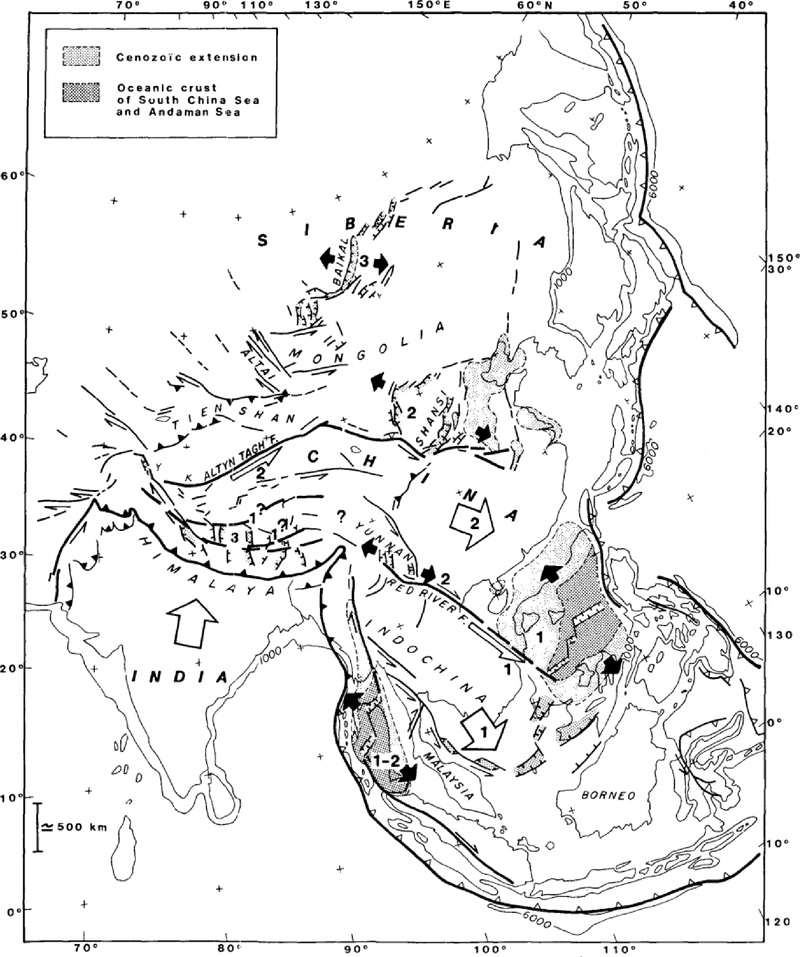
Tectonic model of East Asia associated with the India-Eurasia collision (Tapponnier et al., 1982).
구조지질학에서 다루는 지질구조는 대개 오랜 시간에 걸쳐 반복된 지체구조 운동의 결과로 형성된 최종 산물이며, 과거 여러 지질시대에 일어난 조산운동, 단층운동, 화산활동 등의 흔적을 보존하고 있다. 따라서 특정 지역의 지질구조를 해석하는 일은 단순히 변형구조의 형태를 기재하는 데 그치지 않고, 그 지역이 경험한 지질학적 사건과 지체구조 발달사를 시간적·공간적으로 복원하는 과정이라 할 수 있다. 이러한 해석은 광물자원, 석유, 천연가스, 지열에너지 등 지질자원의 형성과 분포를 이해하는 데에도 중요하다. 많은 지질자원은 암종뿐 아니라 단층, 습곡, 단열대와 같은 지질구조에 의해 배태, 이동, 집적 또는 보존되는 양상이 제어되기 때문이다. 이처럼 구조지질학은 지체구조 진화의 해석과 자원탐사라는 전통적 역할을 수행해 왔으며, 그 과정에서 단층은 변형사의 기록자이자 지하 유체 및 자원 분포를 제어하는 핵심 구조로 주목받아 왔다.
지진은 여전히 예측이 어려운 대표적인 지질현상으로, 현대사회에서도 중요한 과학적 난제 중 하나이다. 그러나 장기적인 지진의 발생기작, 단층운동, 지진재해의 특성에 대한 이해는 현대 과학기술의 발전과 함께 점차 확대되고 있다. 구조지질학은 과거의 지질현상을 해석하는 데 그치지 않고, 미래에 발생 가능한 지질재해를 평가하고 예측하는 데에도 중요한 역할을 한다. 특히 댐, 터널, 원자력발전소와 같이 높은 수준의 안전이 요구되는 사회기반시설의 부지 평가에서 구조지질학적 관점의 조사와 해석은 필수적이다. 또한 조사기술의 발전과 사회적 요구의 증대에 따라 구조지질학은 자원지질학, 지질공학, 지진지질학, 지구동역학 등 실용적 분야로 확장되고 있다. 이러한 발전의 중심에는 단층이 있으며, 특히 단층이 시간에 따라 어떻게 성장하고 변화하는지를 다루는 단층진화 연구의 중요성이 점차 증대되고 있다.
이 논평에서는 국내 구조지질학의 발전 과정을 단층 연구를 중심으로 살펴보고, 단층 및 단층대에 대한 개념과 연구방법의 발전이 활성단층과 지진재해 연구로 어떻게 확장되어 왔는지를 논의하고자 한다. 이를 위해 국내 구조지질학의 발전 과정에서 단층 연구와 밀접하게 관련된 주요 연구 흐름을 개괄하고, 단층진화, 단층손상대, 유체유동, 지진동시성 단층파열 등 최근 단층 연구의 주요 주제를 살펴본다. 또한 2016년 경주지진 이후 크게 확대된 국내 활성단층 연구의 발전과 주요 연구동향을 검토하고, 향후 단층지진원 모델 및 지표변형 재해 평가와 연계된 연구 방향을 논의한다.
2. 국내 구조지질학의 발전과 단층 연구의 전개
국내 구조지질학은 조산운동, 전단대, 분지 진화, 미구조 및 고응력 해석 등 다양한 연구 주제를 중심으로 발전해 왔다. 이들 연구 전반은 한반도의 지체구조 진화와 지질구조 발달사를 이해하는 데 중요하게 기여해 왔으나, 이를 모두 포괄적으로 다루는 것은 본 논평의 범위를 벗어난다. 따라서 여기서는 국내 구조지질학의 발전 과정 가운데 단층 연구가 주요 연구 주제로 자리 잡고, 이후 활성단층과 지진재해 연구로 확장되어 온 흐름을 중심으로 살펴보고자 한다.
우리나라에 근대적인 구조지질학이 본격적으로 도입된 것은 1970년대로 볼 수 있다. 당시 영국의 지질학자들이 당시 국립지질조사소(현 한국지질자원연구원)에 파견되면서 야외지질조사와 구조해석을 기반으로 한 구조지질학의 기틀이 마련되었다. 특히 A.J. Reedman과 C.J.N. Fletcher 등을 통해 국내 지질학자들이 당시 국제적인 구조지질학 연구의 흐름과 방법론을 접할 수 있었고, 이 분야에 대한 학문적 동기부여와 함께 연구 기회를 얻게 되었다. 이후 구조지질학을 전공한 연구자들이 국내 대학과 연구기관에 임용되기 시작하면서 학문적 기반이 점차 확대되었고, 경북대학교와 고려대학교에 근무했던 박봉순 교수에 의해 1976년 국내 최초의 구조지질학 강의가 개설되었다.
1980년대에는 야외지질조사를 기반으로 단층과 습곡 등의 기하학적·운동학적 특성을 해석하고, 이를 한반도의 지체구조 발달사와 연계하려는 연구가 점차 활발해졌다. 1983년 서울대학교에 임용된 김정환 교수는 삼척탄전을 비롯한 고생대 지층의 지질구조와 함탄층(석탄을 포함한 지층) 분포에 관한 체계적인 연구를 수행하였고(e.g., Kim et al., 1989; Kim and Choi, 1990; Kim, 1996; 그림 2), 이러한 연구는 국내 구조지질학이 자원지질 및 지체구조 운동사(tectonic history) 연구와 연계되어 발전하는 데 중요한 역할을 하였다. 같은 시기 한반도의 퇴적분지 발달과 조산운동 등 광역적인 지체구조 운동사에 대한 관심도 확대되었으며, 야외지질조사를 토대로 지질구조를 기재하고 변형사와 고응력 조건을 해석하는 연구가 본격적으로 수행되었다. 이러한 1970~1980년대 국내 구조지질학의 발전 과정과 주요 연구성과는 Kim (2017)에 비교적 상세히 정리되어 있다.
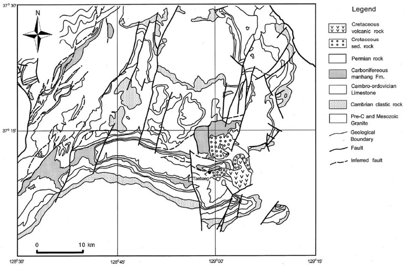
Simplified geological map of the Samcheok Coalfield, compiled based on previous geological and structural studies (e.g., Kim and Choi, 1990; Kim, 2017).
1990년대 이후에는 구조지질학의 연구 대상과 방법론이 더욱 다양해졌다. 석유·천연가스 등 에너지자원 탐사에 대한 관심이 확대되면서 탄성파 탐사와 구조해석을 결합하여 지하 단층과 퇴적분지의 기하를 규명하는 연구가 활성화되었고, 지질연대학, 퇴적학, 지구물리탐사 등과의 융합도 활발해졌다. 또한 암석 및 단층암에 기록된 미세 변형구조를 통해 변형기작과 변형조건을 해석하는 미구조 연구가 본격적으로 도입되었다. 경북대학교 장태우 교수와 고려대학교 이진한 교수 연구팀을 중심으로 관련 연구가 수행되었으며 (e.g., Ree, 1991; Chang and Lee, 1996a, 1996b), 야외지질조사와 미구조 분석을 결합하여 주요 단층대와 전단대의 변형 특성과 운동사를 규명하려는 연구도 이어졌다(e.g., Kim and Kee, 1994). 이와 같은 연구방법의 발전은 단층을 단순한 지질경계나 불연속면이 아니라, 암석의 변형과 지체구조 진화를 기록하는 핵심 구조로 인식하는 데 중요한 기반이 되었다.
한편, 국내에서 단층 연구가 지진 및 지진재해 문제와 직접 연결되기 시작한 것은 양산단층의 활성 가능성에 대한 논의와 밀접한 관련이 있다. Lee and Na (1983)는 미소지진 관측자료를 근거로 양산단층의 활성 가능성을 제기하였으며, 이는 국내에서 활성단층 문제를 과학적 연구 대상으로서 본격적으로 논의하게 된 초기 사례 중 하나로 평가할 수 있다. 이후 1990년대 중후반, 원자력발전 산업의 확대와 함께 원전 부지의 지질학적 안정성 평가가 중요해지면서 단층의 활동성과 지진발생 가능성에 대한 사회적·과학적 관심도 크게 증가하였다. 활성단층 연구 초기에는 조사 경험과 전문인력의 부족으로 해외 전문가의 참여 비중이 높았으나, 이후 원자력발전소 부지조사의 지속적인 수요와 함께 한국지질자원연구원을 중심으로 국내 주도의 조사와 연구가 점차 확대되었다. 이 과정에서 양산단층의 활성 여부, 월성원자력발전소 주변의 수렴단층과 읍천단층 등 주요 단층에 대한 해석 차이와 활성에 대한 논쟁이 치열했으며, 이는 활성단층 연구의 필요성과 중요성을 부각시키는 동시에 단층의 발달사, 최후기 운동시기, 재활동 가능성을 평가하기 위한 조사·해석 기술의 발전을 촉진하였다. 결과적으로 국내 구조지질학은 과거 지층과 지질구조에 기록된 지체구조 발달사를 해석하고 자원탐사에 활용하는 전통적인 연구에서 점차 최근 지질시대의 단층활동과 지진재해를 평가하는 분야로 연구영역을 확장하였으며, 국가 주요 기반시설의 지질학적 안정성을 평가하는 데에도 중요한 역할을 담당하게 되었다.
2000년대 이후에는 우리나라 주요 대단층계의 진화과정과 이들의 구조운동에 따른 백악기 및 신생대 분지 발달에 관한 연구가 활발히 진행되었다(e.g., Choi, 1996; Son et al., 2000, 2013). 또한 우리나라에서 가장 큰 규모의 단층인 양산단층과 울산단층의 발달사와 활동성에 대한 연구도 지속적으로 축적되었다(e.g., Chae and Chang, 1994; Chang, 2002; Choi, 2003; Cheon et al., 2020). 특히 2016년 경주에서 발생한 규모 5.8의 지진은 국내 지진 및 활성단층 연구의 중요성을 크게 부각시키는 계기가 되었다. 이후 정부 주도의 ‘활성단층 지도 제작 사업(2017~2036년)’이 추진되면서 2017년 부경대학교 김영석 교수를 단장으로 하는 ‘국가활성단층연구단’이 출범하였다. 이때부터 구조지질학을 비롯해 지형학, 원격탐사, 지구물리탐사, 지질연대학 등을 연계한 다학제 조사·연구체계가 본격적으로 구축되었다. 이러한 변화는 국내 단층 연구가 지질구조의 형성과 진화를 해석하는 전통적인 영역에서 나아가, 활성단층의 특성을 규명하고 지진재해를 평가하는 실용적 연구 분야로 확장되는 중요한 전환점이 되었다.
3. 단층 연구의 발전과 주요 연구동향
3.1. 단층손상대와 단층진화
일반적으로 단층은 암석이나 지층의 불연속면으로 인식되어 왔으나, 1980년대 이후 주 단층 주변에 발달하는 소규모 단층과 단열 등 2차적인 변형구조의 중요성이 부각되면서 단층을 복합적인 내부구조를 갖는 단층대(fault zone)로 이해하는 관점이 정립되었다(Adams and Sines, 1978; Segall and Pollard, 1983; Scholz, 1990; Martel and Boger, 1998; Kim et al., 2003). 단층대는 변위와 파쇄가 집중되는 단층핵(fault core)과 이를 둘러싸며 다양한 2차 변형구조가 발달하는 단층손상대(fault damage zone)로 구성되며, 단층운동의 영향을 거의 받지 않은 모암(wall rock)과 구분된다(e.g., Caine et al., 1996; Kim et al., 2004). 이러한 개념의 발전은 단층을 단순한 면상 구조가 아닌, 공간적 폭과 복잡한 내부구조를 갖는 3차원 지질구조로 인식하게 한 중요한 전환이었다(그림 3).
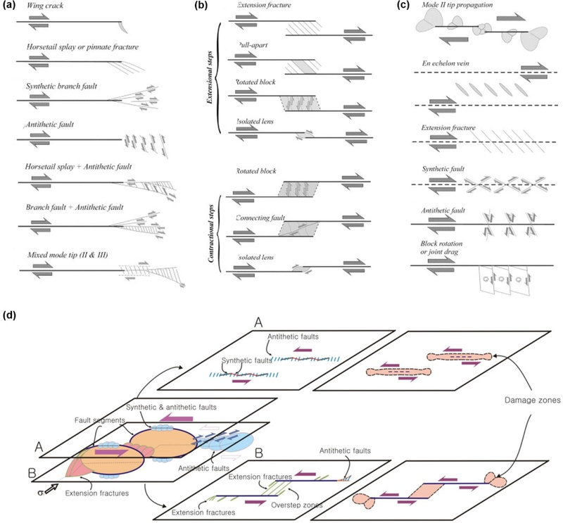
Classification and 3D model of fault damage zones (Kim et al., 2003, 2004). (a) Fault tip damage zone, (b) fault linkage damage zone, and (c) fault wall damage zone. (d) Idealized 3D strike-slip fault model illustrating variations in damage-zone architecture with fault position, including Mode-II structures perpendicular to fault displacement and Mode-III structures parallel to fault displacement.
단층손상대 연구는 단층이 고립된 구조로 성장하기보다 주변 단층들과 상호작용하고 연결되면서 진화한다는 사실을 보여주었다(Peacock, 1991; Peacock and Sanderson, 1991). 특히 이웃한 단층이 서로 연결되는 현상, 즉 ‘단층연결(fault linkage)’은 오늘날 단층이 성장하는 주요 메커니즘 중 하나로 간주되며, 이러한 연결부에서는 다양하고 복잡한 형태의 변형구조가 발달한다(e.g., Cartwright and Mansfield, 1998; Walsh et al., 1999). 또한 단층연구에도 정량적 분석이 시도되면서, 단층이 연결되는 과정에서 단층자취를 따라 관찰되는 ‘변위분포(displacement distribution)’를 분석함으로써 단층이 어떻게 성장해 왔는지를 밝히는 연구들이 수행되었다(그림 4a, 4b). 또한 단층의 전체길이와 누적변위(length-cumulative displacement) 간의 수치적 상관성은 단층 규모와 성장단계를 평가하는 주요 방법으로 자리잡았다(e.g., Cowie and Scholz, 1992; Kim and Sanderson, 2005; 그림 4c). 이러한 연구는 단층을 단순한 면상 구조가 아닌, 복잡한 내부구조와 성장 이력을 갖는 지질구조로 이해하는 과학적 전환점이 되었다.
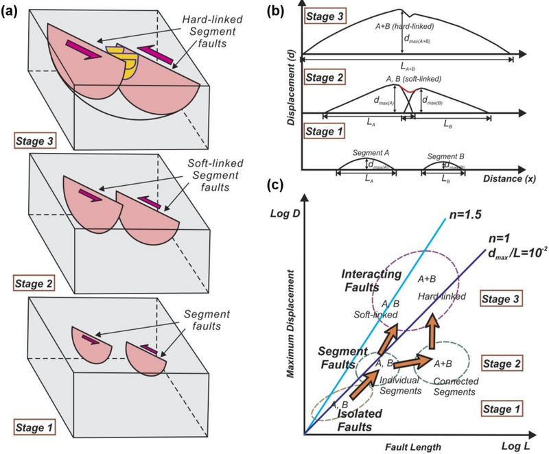
Fault evolution model showing the linkage of two adjacent fault segments (Kim and Sanderson, 2005). The maximum displacement-fault length relationship changes with fault connectivity, and fault length increases rapidly during segment linkage.
특히 Kim et al. (2004)은 단층손상대의 구조와 발달 특성을 3차원적으로 체계화한 모델을 제시함으로써 단층대 연구의 공간적 해석을 확장하였다. 이후 3차원 단층대 개념은 지하수 및 유체유동, 자원탐사, 활성단층과 지진, 지표변형 및 지질재해 평가 등 다양한 분야로 확대 적용되었다. 또한 연구 분야와 관찰 규모에 따라 혼용되던 단층손상대의 용어와 분류체계를 정리하기 위해 Choi et al. (2016)은 3차원 단층손상대를 보다 체계적으로 분류하고 정의하는 개념적 틀을 제안하였다(그림 5). 이러한 연구들은 국내 연구진이 단층손상대의 3차원적 구조와 진화과정을 이해하는 데 기여한 대표적인 사례라 할 수 있다.
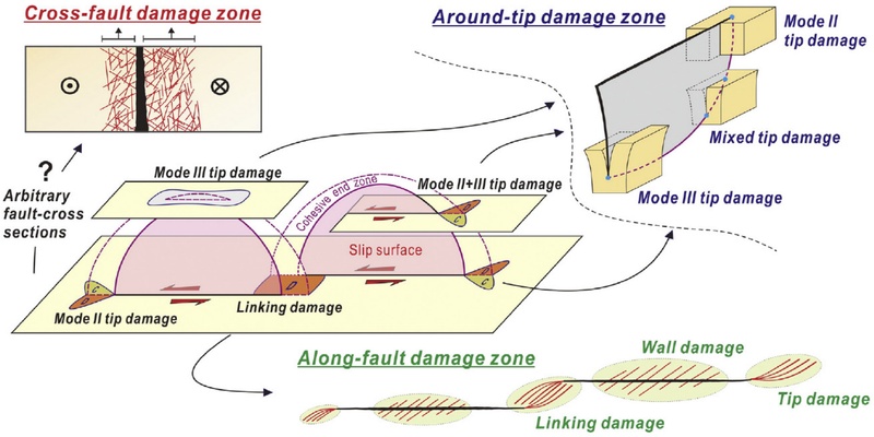
Descriptive classification of damage-zone structures into along-fault, around-tip, and cross-fault damage zones (Choi et al., 2016). C and D denote contractional and dilational domains, respectively.
그러나 단층손상대의 구조는 모암의 암종과 물성, 단층의 규모와 성장단계, 지체구조적 운동사 및 지구조 역전 여부 등에 따라 크게 달라질 수 있어 하나의 일반화된 모델로 설명하기에는 한계가 있다. 특히 지질도 규모의 대단층과 노두 규모의 단층에 비해 수백 m 규모의 중규모 단층에 대한 관찰자료가 상대적으로 부족하여, 단층 규모에 따른 길이-변위 관계의 변화와 소규모 단층이 대규모 단층으로 성장하는 과정을 연속적으로 이해하는 데 제약이 있다. 따라서 향후에는 다양한 암종과 지체구조 환경에서 중규모 단층을 포함한 다중 규모의 단층손상대 자료를 확보하고, 이를 3차원 구조 및 정량적 성장모델과 연계함으로써 단층의 개시, 연결, 성장, 재활성에 이르는 진화 과정을 통합적으로 규명할 필요가 있다.
3.2. 단층과 유체유동
지각 내 유체의 유동은 여러 중요한 지질현상과 관련된다. 예를 들어, 지하수 오염원의 이동경로, 지진발생 메커니즘, 광상(광물자원)의 형성, 석유·가스 및 지열과 같은 에너지자원의 이동과 배태 등을 들 수 있다. 단층과 단열은 암석 내 주요 유체 이동경로로 작용하며, 단층대의 내부구조와 물성에 따라 유체의 통로(conduit) 또는 장벽(barrier)으로 기능할 수 있다. 따라서 단층·단열의 구조적 특성과 유체유동 간의 관계를 규명하는 것은 지각 내 물질이동을 이해하고, 자원탐사와 지하수 관리뿐 아니라 지질환경 및 재해 안전성을 평가하는 데 중요한 구조지질학적 과제이다.
단층·단열망의 연결성과 유체 이동경로의 관계에 대한 연구는 다양한 지질학적 기록을 통해 발전해 왔다. Kim and Sanderson (2010)은 석회동굴 내 단층 연결부에 상대적으로 큰 종유석이 집중되는 양상을 통해 서로 연결된 단층과 단열이 지하수의 우세한 이동경로로 작용할 수 있음을 제시하였다(그림 6a). Kim et al. (2012)은 비다공질 암석에서 단층과 단열을 따라 발달하는 광맥과 세맥의 분포를 이용하여 단열망의 연결성이 열수의 이동과 침전을 제어할 수 있음을 보여주었으며, Yang and Kim (2022)은 기존 단층·단열을 따라 관입한 암맥을 통해 불연속구조의 연결성이 마그마 이동과 관입체의 발달에 중요한 영향을 미칠 수 있음을 제시하였다(그림 6b). 최근에는 단열밀도 중심의 분석에서 나아가 단열망(fracture network)의 연결성을 위상학적(topological) 방법으로 정량화하고 이를 유체유동과 연계하는 연구가 활발히 이루어지고 있다(e.g., Sanderson and Nixon, 2015; 그림 7). Kim et al. (2022)은 이러한 접근을 습곡대에 적용하여 습곡 형성에 수반되는 취성변형과 변형률 분배가 단열망의 연결성과 층간 유체이동을 제어할 수 있음을 제시하였고, Park et al. (2026)은 화산-퇴적층에서 암상과 단열망의 연결성이 투수성의 이방성과 유체유동의 공간적 차이를 결정할 수 있음을 보여주었다.
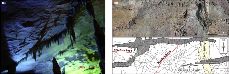
Examples illustrating the relationship between faults and fluid flow. (a) Stalactites developed along faults on the ceiling of Huanglong Cave, China (Kim and Sanderson, 2010). Larger stalactites are concentrated in extensional linkage zones, suggesting preferential fluid flow along these fault zones. (b) Dikes intruded along fractures in a horizontal outcrop at Sinseondae, Geoje Island, Korea (Yang and Kim, 2022).
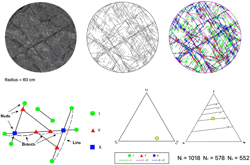
Basic concept and application example of topological fracture-network analysis for evaluating fault and fracture connectivity (Sanderson and Nixon, 2015).
한편, 단층의 재활성화와 진화가 유체의 이동·집적 및 광화작용을 어떻게 제어하는가에 대한 연구도 확대되고 있다. Kwak et al. (2024)은 충남분지 북동부의 지구조 역전 과정에서 단층 재활성화와 열수 이동, 금 광화작용이 밀접하게 연계되어 있음을 제시하였으며, Lee et al. (2025)은 울릉분지 남서부에서 3차원 단층구조와 탄화수소의 이동·집적 간의 관계를 분석하였다. 또한 Cheon et al. (2026)은 와읍분지의 심부 시추코어를 통해 반복적인 단층활동과 유체-암석 상호작용이 단층대 내부구조의 진화와 밀접하게 연계되어 있음을 규명하였다. 이러한 연구들은 국내 단층-유체 연구가 단순한 구조 기재를 넘어, 단열망의 연결성, 암상과 투수성, 단층의 재활성화 및 진화이력을 유체의 이동·집적·차단과 통합적으로 해석하는 방향으로 발전하고 있음을 보여준다.
이러한 단층-유체 상호작용에 대한 이해는 자원탐사뿐 아니라 이산화탄소 지중저장시설, 방사성폐기물 처분, 지열개발 및 심부 지질환경 안전성 평가 등에서도 중요성이 커지고 있다. 특히 단층이 장기간 유체 이동을 차단하는지, 또는 잠재적 누출경로로 작용하는지를 평가하기 위해서는 단층핵과 손상대의 비균질성, 단열의 밀도·방향성·연결성, 광물 충전 및 단층진화 이력을 함께 고려할 필요가 있다. 향후에는 야외 구조지질조사와 시추·검층, 지구물리 및 수리지질 자료를 통합하여 실제 단층대의 구조와 진화 특성을 반영한 3차원 단층-유체 모델을 구축하고, 이를 통해 단층의 구조와 진화가 지각 내 유체의 이동·저류·집적 및 차단을 어떻게 제어하는지를 정량적으로 규명할 필요가 있다.
3.3. 지진동시성 단층파열
지진은 단층에 축적된 지구조적 응력이 임계점에 도달하면 단층이 파열(rupture)되면서 발생하며, 이러한 발생 메커니즘은 탄성반발이론(elastic rebound theory)으로 설명된다(Reid, 1910). 따라서 단층은 판구조운동에 의한 응력과 지진 발생을 연결하는 핵심 지질구조로, 지진동시성 지표파열(co-seismic surface rupture)에 대한 조사는 단층과 지진의 상관성을 규명하는 중요한 연구방법으로 자리잡았다(Choi et al., 2017). 또한 여진의 공간적 분포가 단층손상대와 밀접하게 대응하는 사례가 보고되어 왔으며(Sibson, 1989; Day and Henry, 2003; 그림 8), 이는 단층대 내부구조가 지진 파열과 변형을 제어할 수 있음을 보여준다.
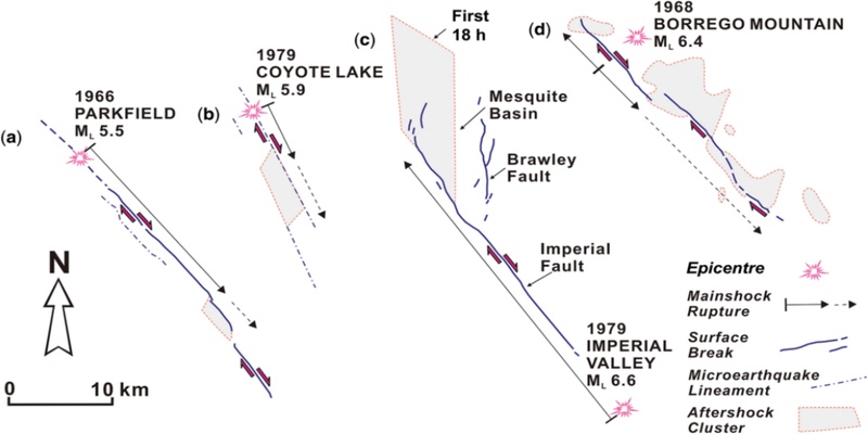
Mainshock locations, fault traces, surface-rupture directions, and aftershock distribution areas associated with strike-slip earthquakes around the San Andreas Fault, western United States. The aftershock zones generally correspond to the locations of fault damage zones (Sibson, 1989; Kim and Sanderson, 2008).
최근 단층에 내재된 구조적 특성이 지진동시성 단층파열과 지진의 재발 특성에 어떠한 영향을 미치는지에 관한 연구가 활발히 수행되고 있다(Vallage et al., 2015; Choi et al., 2018). 대규모 단층은 일반적으로 여러 단층구간 또는 분절(segment)이 연결되어 형성된 진화의 산물이다. 이들 구간의 연결 특성은 지진동시성 단층파열 과정(개시, 전파, 종결 등)에 영향을 미치며, 결과적으로 지진의 재발 특성에도 영향을 준다(King and Nabelek, 1985; Knuepfer, 1989; King et al., 1994). 따라서 일반적으로 개별 지진은 단층 전체가 아닌 일부 단층분절에서 발생하는 경우가 많고, 이러한 분절화와 구간별 응력상태는 '지진공백(Seismic Gap)' 개념과도 밀접하게 관련된다(McCann et al., 1979). 또한 한 단층분절의 파열은 인접 분절 또는 주변 단층의 응력상태를 변화시켜 후속 지진을 촉발할 수 있으며, 이러한 과정은 점진적 파열(progressive failure) 또는 연쇄적인 지진발생으로 나타날 수 있다(Stein et al., 1997; 그림 9). 북아나톨리아단층에서 관찰된 대지진의 시·공간적 이동은 이러한 현상을 보여주는 대표적인 장기적 사례이다(Barka and Kadinsky-Cade, 1988). 지난 2023년 튀르키예-시리아에서 Mw 7.8 지진에 이어 약 9시간 후 인접한 단층계에서 Mw 7.7 지진이 연쇄적으로 발생하였으며, 이는 하나의 대규모 단층파열이 주변 단층의 응력상태를 변화시켜 유사 규모의 후속 지진을 촉발할 수 있음을 보여주는 대표적인 사례이다. 최근 연구에서는 이러한 현상을 복잡한 단층망 내에서의 응력 전이와 연쇄적 파열(cascading rupture)의 관점에서 해석하고 있다(Liu et al., 2023; Zhang et al., 2023).
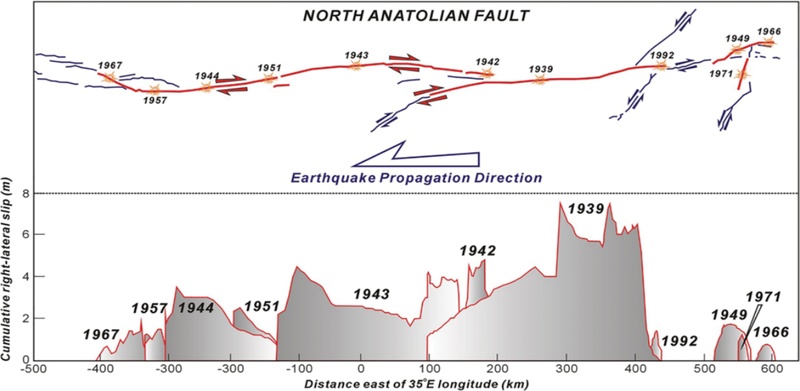
Sequential occurrence of earthquakes and associated displacements along the North Anatolian Fault, Türkiye. This example clearly illustrates the progressive migration of earthquakes within a segmented fault system (Stein et al., 1997; Jin and Kim, 2010).
최근에는 지진 전·후에 획득된 위성자료 상관분석(InSAR)과 지진 직후 획득된 영상자료 등을 이용해 지진동시성 지표파열을 조사할 수 있으며, 이에 대한 데이터셋도 점차 증가하고 있다(e.g., Peltzer et al., 1998; Klinger et al., 2005; Milliner et al., 2015). 최신 연구결과는 야외조사와 현장측량을 중심으로 수행된 이전의 연구결과와 차이를 보이는데, 가장 주목할 만한 점은 단층파열이 반드시 단층선(지표파열 자취) 위에서만 발생하지 않는다는 것이다. 전체 지표 변형(변위)의 약 10~30% 정도가 수십에서 수백 미터 폭의 변형대 내에 분산됨이 확인되었으며, 이를 단층주변 변형(off-fault deformation)이라 한다(Antoine et al., 2021; Bae et al., 2025; Choi and Choi, 2026; 그림 10). 이러한 분산 변형의 정도는 지진의 규모나 단층의 구조적 특성과 위치에 따라 달라지며, 주로 단층분절 사이의 연결부나 단층파열이 종결되는 영역에서 크게 나타나는 경향이 있다. 이와 유사한 연구결과 중 하나는 주향이동지진에 수반된 주 변위성분인 주향이동성분이 단층 연결부에서는 감소하는 반면 경사이동 변위성분은 증가하며 변화하는, 소위 ‘변위보상(slip compensation)’이 발생한다는 것으로(Choi et al., 2012), 이는 단층대 내에서 전체 지표 변형량이 분산·재분배되는 변위 수지의 관점과 잘 부합되는 결과로 해석된다.
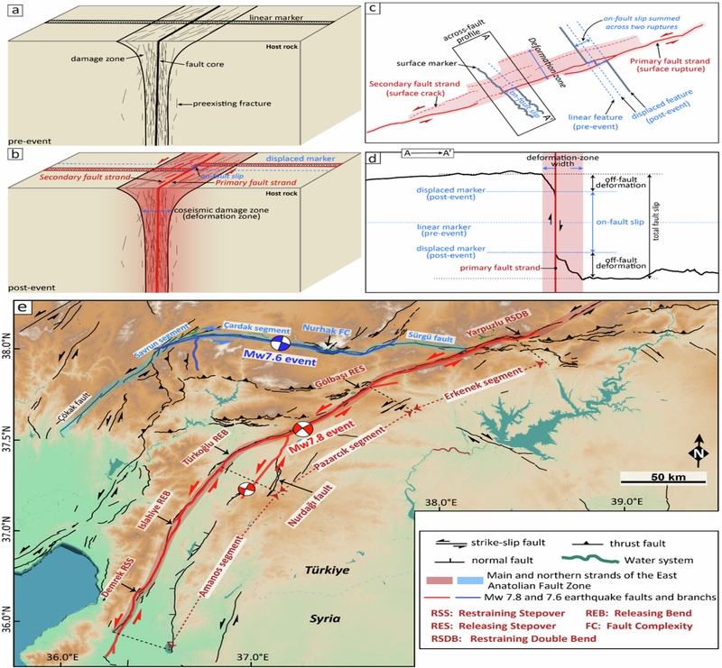
Multi-segment rupture and deformation partitioning associated with the 2023 Türkiye earthquake sequence (Xi et al., 2025). (a, b) Internal fault-zone structure and coseismic deformation patterns. (c, d) Localized displacement along surface ruptures and distributed deformation around the faults. (e) Segmented active faults around the East Anatolian Fault, Türkiye, and surface-rupture traces produced by the 2023 earthquake sequence.
결과적으로, 이전 연구에서 주로 기재적·정성적 방법으로 조사 및 해석되었던 단층손상대와 지진의 상관성이 최근의 연구기술과 정량적 결과로 뒷받침되고 있다고 볼 수 있다. 한편, 지진의 규모는 지진동시성 단층파열의 면적(지표파열의 길이와 파열면의 깊이)과 변위량에 비례하며, 이들 간의 경험식(e.g., Wells and Coppersmith, 1994)은 지진과 활성단층을 다루는 연구분야에서 핵심적인 참고자료로 활용되고 있다. 그러나 당시 조사자료에 포함되어 있지 않았던 단층 주변의 분산변형 개념에 대한 이해가 높아지면서, 2차 변형을 고려한 지진규모와 지진파열, 변위량 간의 새로운 경험식이 필요한 실정이다. 또한, 한 번의 지진과 관련된 단층파열의 변형분산과 오랜 단층진화의 산물인 단층손상대 사이를 구분하는 중요성과 동시에 이들의 상호작용을 파악하려는 새로운 시도들이 이루어지고 있다(e.g., Choi et al., 2018; Klinger et al., 2018).
4. 활성단층 연구동향
4.1. 활성단층 및 지진재해평가 연구
1975년 중국 랴오닝성의 규모 7.3의 하이청지진은 역사상 가장 성공적이자 거의 유일한 지진예측 사례이다. 이러한 평가가 50년간 지속되고 있다는 점은 역설적으로 현재의 과학기술로도 지진예측이 거의 불가능하다는 것을 의미하며, 지진예측 기술 확보는 지구과학을 포함한 과학기술 전 분야에서 여전히 최대 난제 중 하나로 꼽힌다. 이에 따라 오늘날의 지진재해 대응은 단기적 전조현상에 의존한 예측보다는 과거 지진자료를 바탕으로 일정 기간 내 특정 규모의 지진이 발생할 확률과 이에 따른 지진동·지반가속도를 평가하는 지진재해평가(seismic hazard analysis)에 중점을 두고 있다. 이러한 결과는 지진재해도(seismic hazard map)로 제시되며, 건축물과 주요 시설의 내진설계를 위한 핵심 기초자료로 활용된다.
지진재해평가에 이용되는 과거 지진자료는 크게 지진계에 관측된 계기지진, 역사문헌에 기록된 역사지진, 그리고 지표 퇴적층에 기록된 고(古)지진으로 구분된다. 이 중 고지진 자료란 순차적으로 퇴적된 지표의 퇴적층이 과거의 지진(즉, 단층활동)으로 인해 변위된 지질학적 기록을 의미한다. 여기서 중요한 개념 중 하나는, 소규모 지진은 땅의 흔들림만 유발할 뿐 지표가 파열되지 않으나, 규모 약 6 이상의 중대규모 지진은 심부에서의 단층파열 면적이 넓어서 지표파열, 즉 지표까지 도달하여 퇴적층의 변위를 수반한다는 점이다(e.g., Bonilla, 1988). 따라서 고지진 기록이란, 과거에 발생했던 지진 중 규모가 컸던 대규모 지진에 관한 자료라 할 수 있다. 암석권 내에는 수많은 단층이 존재하지만, 고지진 기록을 보이는 단층은 최근 지질시대에 중대형 지진을 일으킨 바 있는 ‘활성단층(active fault)’으로 정의되며, 그렇지 않은 비활성단층과 구분된다. 활성단층 및 그 정보는 지진재해평가에서 단층지진원으로 활용되므로, 지진재해 대비 측면에서 그 연구의 중요성이 매우 크다.
‘활성단층’의 개념적 정의(최근 지질시대에 활동을 하였고, 미래에 다시 활동할 가능성이 있는 단층) 중 “최근”이라는 의미의 모호성 때문에, 최후 활동시기를 기준으로 활성단층을 정의하는 것이 일반적이다(Kim et al., 2011). 그러나 국가나 사용자들의 목적에 따라 이 ‘최근 지질시대’를 어디까지로 정할 것인가에 대한 다양한 기준이 존재하는데, 보통은 과거 약 11,700년 전 이내, 즉 홀로세(Holocene)에 활동한 단층을 의미했으나, 더 오래전에 활동했던 단층이 재활성화되는 사례가 다수 보고됨에 따라 최근에는 약 258만 년 전 이내, 즉 제4기(Quaternary)에 활동한 단층을 활성 가능성이 있는 단층으로 간주하는 것이 세계적 추세이다. 우리나라 역시 2015년 ‘활성단층정비기획단(단장: 한국교원대학교 경재복 교수)’을 통해 국내 지구조 및 지진 환경 특성을 반영한 활성단층의 정의와 분류체계를 수립하였으며, 그 결과 제4기에 활동한 단층을 활성단층으로 정의하고 마지막 활동시기를 기준으로 4개의 그룹으로 구분하였다(Kim et al., 2011). 한편, 유사한 개념이지만 원자력발전소 부지조사에서 사용하는 ‘활동성단층(capable fault)’의 정의도 있는데(Im et al., 2004), 이는 5만 년 이내 1회 또는 50만 년 이내 2회 이상 활동한 단층을 의미한다.
활성단층을 누가 언제 최초로 연구했는지를 단정하기는 어렵지만, 활성단층에 대한 개념과 연구방법을 정립하고 체계화한 인물로는 James McCalpin이 널리 알려져 있다. 그는 1996년 초판이 발행된 『Paleoseismology』라는 저서를 통해 활성단층의 개념, 조사방법, 그리고 다양한 지형 및 지질환경에서의 특성에 대해 상세히 기술하였다. 고지진 기록은 과거 대형지진으로 인한 지진동시성 지표파열(co-seismic surface rupture)의 흔적으로, 크게 제4기 지형 변위와 제4기 퇴적층(또는 층서) 변위로 나뉜다. 따라서 활성단층 조사는 주로 지형분석으로부터 시작되며, 위성, 항공, 드론 등 원격탐사를 통해 취득한 지형 및 영상자료가 활용된다. 최근에는 고해상도 라이다(Light Detection And Ranging: LiDAR) 자료가 주요하게 활용되는데, 이는 지형변위를 판독하는 데 장애가 되는 지표상의 구조물이나 식생을 기술적으로 제거할 수 있기 때문이다.
지형분석을 통해 판독된 선형구조(즉, 잠재적인 활성단층 자취)를 따라 제4기 지층의 층서변위를 추적하기 위한 야외지질조사, 전기비저항탐사, 굴착조사 등이 수행된다. 이러한 조사들의 최종 목적은 제4기 지층의 층서변위를 확인하는 것이며, 특히 굴착단면에 드러난 지표 근처 신기 퇴적층의 변위여부가 핵심적이다. 지진을 겪은 지층 중 가장 젊은 지층의 퇴적연대와 지진을 겪지 않은 지층 중 가장 오래된 지층의 퇴적연대는 해당 지진이 발생했던 시기를 제한하며, 이를 통해 활성단층 여부 및 그룹이 결정된다. 이때 지층의 퇴적연대는 주로 방사성탄소 연대측정법과 광여기 루미네선스(Optically Stimulated Luminescence: OSL) 연대측정법을 통해 도출된다(Choi et al., 2003). 한편, 제4기 퇴적층이 존재하지 않을 경우에는 단층암을 대상으로 전자 스핀공명(Electron Spin Resonance: ESR) 연대를 측정하여 지진의 발생 시기를 평가하기도 하는데, 이는 지진동시성 단층파열로 인해 단층암에 마찰열 및 파쇄작용이 발생하면서 ESR 신호가 초기화된다는 이론에 근거한 것이다. 단층암 ESR 연대측정법 및 국내 연구현황에 대한 내용은 2020년 지질학회지에 발표된 논문(Kim and Lee, 2020)에 상세히 소개되어 있다.
4.2. 국내 활성단층 연구의 발전 및 쟁점
우리나라에서의 고지진 연구는 Okada 교수와 경재복 교수에 의해 시작되었는데, 이들은 국내 최초로 굴착조사를 통한 고지진 조사를 수행하였다(Kyung et al., 1999; Kyung, 2003). 이후 점차 고지진학의 개념이 확립되면서, 활성단층 조사를 위한 대규모 굴착조사와 제4기 연대분석이 도입되고 활성화되었다. 2000년대 이전까지는 활성단층 조사의 도입기라 할 수 있는데, 이 기간에 한반도 남동부의 20여 곳에서 지점 단위의 활성단층이 보고되었다(Kee et al., 2007; 그림 11). 한편, 활성단층이 가지는 사회적 이슈로 인해 활성단층 여부에 대한 끊임없는 논쟁이 지속된 것도 사실이다. 이러한 활성단층 논쟁의 중심에는 월성원자력발전소 근처의 수렴단층과 읍천단층이 있었으며, 특히 읍천단층의 경우 국내 구조지질학의 제2세대라고 할 수 있는 학자들(기원서, 최원학, 김영석, 손문 등)이 조사에 참여하였다. 이들은 단층진화 개념에 기반한 고지진 분석 및 해석을 바탕으로 읍천단층 조사를 수행하였고, 지형 및 선형구조 분석, 굴착조사, 변위 분석, 해안단구 연대측정, 방사성탄소 연대측정 등을 통해 현대적 방법의 활성단층 연구를 수행하였다. Kim et al. (2011)은 활성단층의 기본적인 개념과 현대적인 연구 방법을 지질학회지 「활성단층의 이해」를 통해 국내에 소개하였고, 이를 계기로 국제적 수준에 부합하는 활성단층에 대한 본격적인 연구와 개념 정립이 이루어지기 시작하였다. 또한 변위율이 낮고 지진발생 빈도가 낮은 국내 활성단층 조사의 어려움을 극복하고, 해외 자료와의 비교연구를 위해 국외 활성단층을 대상으로 연구가 수행되기도 하였다(Choi et al., 2012).
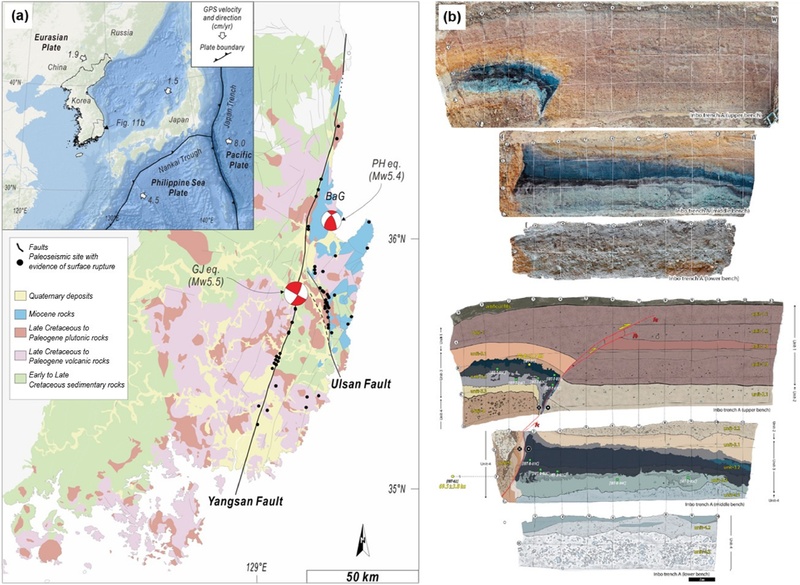
(a) Distribution of active faults mapped in southeastern Korea (modified from Kee et al., 2007). Geologic evidence of paleo-earthquake surface rupture has been reported predominantly along the Yangsan Fault and Ulsan Fault. The focal mechanisms indicate the 2016 Gyeongju and 2017 Pohang earthquakes. (b) Evidence of surface rupture associated with a large prehistoric earthquake along the Yangsan Fault, identified through a large-scale trench excavation at the Inbo site in the southern Yangsan Fault (Cheon et al., 2020).
우리나라의 활성단층 연구는 2017년 국가활성단층연구단이 출범한 이후 한 단계 발전하였는데, 이는 다학제간 표준화된 연구체계 수립과 국외 선진 연구기술의 도입이 이루어졌기 때문이다. 특히, 대형지진의 재발주기가 긴 반면 침식 및 퇴적률이 높아 고지진 기록이 잘 보존되기 어려운 우리나라의 지진지질학적 여건을 극복하기 위한 기술이 개발되고 있다. 이러한 연구의 가장 대표적인 성과로는 한반도 남동부가 아닌 강원권과 충청권에서 활성단층이 보고된 점을 들 수 있다(Kim et al., 2022, 2024). 또한, 굴착단면에서 단층 주변의 미고결 퇴적층에 대한 미구조 분석이 도입되어 지진성 변형구조를 파악하고 분석하는 데 중요한 역할을 하고 있다(Han et al., 2020; Park et al., 2020).
지진재해평가에 활용될 수 있는 단층지진원 모델을 확보하기 위한 기술도 개발되고 있다. 이를 위해서는 주요 활성단층에 대한 분절화 연구를 통해 각 단층분절의 기하 및 변위율 정보를 확보하는 것이 필수적이다(Lee and Jin, 1991; Kim and Choi, 2024). 그러나 단층기하와 변위율 정보가 많지 않으며, 특히 양산단층을 비롯한 주향이동단층을 대상으로 수평변위 정보를 도출하는 것은 쉽지 않다. 주로 굴착조사를 통해 수행된 이전 활성단층 조사에서는 굴착단면에서 측정된 수직변위와 단층조선(slip lineation)을 이용해 수평변위를 산출하기도 하였다(Song et al., 2020). 그러나 이 분석법은 미고결 퇴적층의 층리가 수평이고 측방 연속성이 양호하다는 전제가 필요하며, 최근 이러한 한계점을 극복하고자 지형복원을 통해 수평변위를 평가하려는 시도가 이어지고 있다(Kim et al., 2020; Choi et al., 2024; Kim et al., 2024). 특히, 활성단층을 따른 변위지형에 대한 퇴적물 기원지 분석을 통해 과거 주향이동지진에 의해 변위된 지형을 수평적으로 복원하는 연구들도 수행되었다(Lee et al., 2024). 향후 다양한 접근과 시도를 통해 합리적인 수평변위율을 확보할 필요가 있으며, 이를 위해서는 지형면 복원과 지형면의 형성시기에 대한 연대분석기술 개발이 요구된다.
한편, 우리나라와 같이 중대형 지진의 재발주기가 수천~수만 년으로 긴 반면 침식·퇴적 등 지표 지질작용이 활발한 지역에서는 고지진 기록이 단속적으로 보존될 가능성이 높기 때문에, 단층조사 결과와 계기지진 자료를 연계한 단층 구조 해석이 요구된다. 특히 지표에서 확보된 조사결과는 단층의 위치와 변위 양상을 가장 직접적으로 확인할 수 있는 장점이 있으므로, 지표에서 확인된 단층 정보를 기준점으로 하여 단층 구조의 3차원 기하를 단계적으로 규명하는 접근이 요구된다. 이를 위해서는 굴착조사와 지형·지질조사를 통해 확보된 단층정보를 미소지진 발생 위치, 심부 탄성파 탐사자료, 시추자료 등과 통합하여 지표와 지하 단층 구조의 연결성을 검증할 필요가 있다. 다만 활성단층은 단일한 평면 구조가 아니라 분절, 분기, 계단식 배열, 손상대 발달 등 복잡한 단층대 구조로 존재할 수 있으므로, 향후 단층지진원 모델 구축에는 이러한 구조적 복잡성을 반영한 3차원 단층모델 개발이 병행되어야 한다.
4.3. 지표변형 재해
앞서 언급한 지진기록이나 활성단층 정보를 기반으로 한 지진재해 평가는 주로 지진동에 대비한 것이지만, 최근에는 더욱 심각한 피해를 유발하는 영구적인 지표파열이나 지표변형과 관련된 재해에 대비한 연구의 중요성도 높아지고 있다. 그 이유는, 지진동의 경우 내진설계와 지진 조기경보를 통해 어느 정도 피해를 줄이거나 대비가 가능하지만, 지표파열은 현재의 과학기술로는 피해를 거의 막을 수 없기 때문이다(e.g., 1995년 규모 6.9 일본 고베지진, 1999년 규모 7.6 대만 치치지진). 따라서 활성단층의 위치를 정확히 파악하는 것은 잠재적인 지진에 의한 지표파열이 발생할 수 있는 지역을 사전에 예측하고 이를 회피하는 데 중요한 역할을 한다. 최근에는 지진동시성 지표파열에 대한 정밀조사를 통해 주 단층 외에도 지표변형이 발생하는 영역에 관한 연구결과들이 발표되고 있다. 또한, 잠재적인 지진에 의한 지표파열의 변위를 확률론적으로 추정하는 확률론적 단층변위재해평가(Probabilistic Fault Displacement Hazard Analysis: PFDHA) 기법도 개발되었다(e.g., Im et al., 2016).
단층대의 구조적 특성을 반영하여 지진 시 지표파열의 영향범위를 평가하는 개념으로는 단층 회피구역(fault avoidance zone)이 있다(Villamor et al., 2012; He et al., 2022). 이는 활성단층의 위치, 지표변형대의 폭 및 안전이격거리를 종합적으로 고려하여 지표파열에 의한 직접적인 피해 가능성이 높은 영역을 사전에 회피하도록 설정하는 공간적 개념이다. 이와 유사한 Respect Distance 개념은 고준위방사성폐기물 심층처분 연구에서 제안된 것으로, 초기에는 주요 파쇄대로부터 처분공을 이격하여 핵종 이동 가능성을 낮추기 위한 기준으로 활용되었다(Munier and Hökmark, 2004). 이후에는 단층 재활성화 시 발생 가능한 2차 전단변위와 암반 변형으로부터 처분용기를 보호하기 위한 단층·변형대 경계로부터의 안전이격거리 개념으로 확장되었다. 한편, 경사이동운동을 포함하는 지진은 단층을 기준으로 상반에 일반적으로 더 큰 피해를 유발하여 상반과 하반 간 피해 양상과 규모에 큰 차이를 보인다(e.g., 1999년 규모 7.6 이즈미트 지진). 또한 주향이동지진의 경우에도 단층의 운동감각과 단층대 내에서의 위치(연결부, 말단부 등)에 따라 피해 양상과 규모에 큰 차이를 보인다. 후자의 경우, 단층손상대에 대한 개념이 지진재해와 직접적으로 연결된다고 볼 수 있다. 다행히도 단층손상대는 비교적 일정한 패턴을 보이므로, 이 특성을 잘 이해하고 활성단층 조사를 수행한다면 지진재해의 예측과 저감에 기여할 수 있을 것이다. 결과적으로 특정 활성단층에 대한 단층 회피구역을 평가하고 지표파열로부터의 피해에 대비하기 위해서는, 단층의 종류와 운동 특성 그리고 단층손상대에 대한 이해가 중요하다(Jin and Kim, 2018; 그림 12).
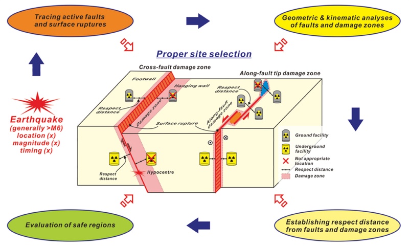
Schematic illustration of a seismological and geological stability assessment considering surface-deformation hazards in areas surrounding active faults (modified from Jin and Kim, 2018), highlighting the usefulness of the fault damage zone concept for identifying areas that are relatively safe from active-fault-related surface deformation.
5. 논의 및 향후 전망
단층 연구는 초기의 기재적·정성적 분석에서 출발하여 단층의 운동학·동역학 및 진화과정을 정량적으로 분석하는 방향으로 발전해 왔다. 최근에는 원격탐사, 지구물리탐사, 시추 및 수치모델링 기술의 발전과 함께 단층의 3차원 구조와 내부 특성에 대한 이해가 심화되면서, 자원탐사, 유체유동, 지진발생기작 및 지진재해평가 등 다양한 분야로 연구영역이 확장되고 있다. 특히 에너지산업과 관련된 국가 주요시설의 부지조사와 지질·지진학적 안정성 평가에서 단층의 구조와 진화 특성을 정확히 규명하는 중요성이 더욱 부각되고 있다.
국내 활성단층 연구는 2016년 경주지진과 국가활성단층연구단 출범을 계기로 크게 발전하였다. 다학제적 조사체계와 고해상도 원격탐사, 굴착조사, 연대측정 등의 기법이 정립되면서 한반도 여러 지역에서 새로운 활성단층 및 고지진 자료가 축적되고 있으며, 최근에는 단층분절, 변위량과 변위율, 고지진 이력 등 지진재해평가에 직접 활용 가능한 정량정보를 확보하는 방향으로 연구가 발전하고 있다. 그러나 신뢰도 높은 단층지진원 모델을 구축하기 위해서는 여전히 단층의 3차원 기하, 분절구조, 장기 변위율 및 재발특성에 관한 자료가 부족하다. 특히 우리나라와 같은 판내부 환경에서는 대형지진의 재발주기가 길고 기존 단층의 재활성화 가능성이 존재하므로, 단순한 주기적 재발모델보다 단층분절 간 상호작용과 응력전이, 3차원 단층구조를 함께 고려하는 접근이 필요하다.
우리나라와 같이 지각판 내부에 위치한 지역은 대형지진의 발생빈도가 낮은 반면, 지진재해에 대한 경험과 대비가 상대적으로 제한적이어서 발생 시 피해가 크게 나타날 가능성이 있다. 이러한 특성을 고려할 때, 지진재해평가는 지진동뿐 아니라 지표파열과 영구변형까지 포괄하는 방향으로 확대될 필요가 있다. 최근 연구에서 확인되는 단층주변 변형(off-fault deformation)과 단층 연결부·말단부에서의 복잡한 지표변형은 기존의 단순화된 단층모델과 지진규모-변위 관계를 보완할 필요성을 보여준다. 따라서 지표에서 확인된 활성단층 정보를 심부 지구물리·시추 및 계기지진 자료와 연계하여 3차원 단층모델을 구축하고, 이를 단층지진원 모델과 확률론적 단층변위재해평가(PFDHA)에 연결하는 연구가 중요하다. 궁극적으로 국내 단층 연구는 단층의 진화와 3차원 구조에 대한 이해를 바탕으로 지진발생과 지표변형을 정량적으로 평가하고, 이를 실질적인 지진재해 저감과 주요 시설의 안전성 확보로 연결하는 방향으로 발전해야 할 것이다.
Acknowledgments
이 논평은 한국지질자원연구원 기본사업(GP2025-013; 판내부 중대형지진 재발모델 기반 한반도 잠재지진특성 평가 연구)과 행정안전부 지진위험분석 및 관리기술개발사업(2022-MOIS62-001; 한반도 단층구조선의 조사 및 평가기술 개발(2단계))의 지원을 받아 수행되었다.
References
-
Adams, M. and Sines, G., 1978, Crack extensions from flaws in a brittle material subjected to compression. Tectonophysics, 49, 97-118.
[https://doi.org/10.1016/0040-1951(78)90099-9]

-
Antoine, S.L., Klinger, Y., Delorme, A., Wang, K., Bürgmann, R. and Gold, R.D., 2021, Diffuse deformation and surface faulting distribution from submetric image correlation along the 2019 Ridgecrest, California, ruptures. Bulletin of the Seismological Society of America, 111, 2275-2302.
[https://doi.org/10.1785/0120210036]
-
Bae, H.-K., Oh, G.-W. and Choi, J.-H., 2025, Coseismic surface deformation analyses using SAR and optical images: 2023 Kahramanmaraş earthquake sequence, Türkiye. Turkish Journal of Earth Sciences, 34, 709-723.
[https://doi.org/10.55730/1300-0985.1988]
-
Barka, A.A. and Kadinsky-Cade, K., 1988, Strike-slip fault geometry in Turkey and its influence on earthquake activity. Tectonics, 7, 663-684.
[https://doi.org/10.1029/TC007i003p00663]
-
Bonilla, M.G., 1988, Minimum earthquake magnitude associated with coseismic surface faulting. Bulletin of the Association of Engineering Geologists, 25, 17-29.
[https://doi.org/10.2113/gseegeosci.xxv.1.17]
-
Caine, J.S., Evans, J.P. and Foster, C.B., 1996, Fault zone architecture and permeability structure. Geology, 24, 1025-1028.
[https://doi.org/10.1130/0091-7613(1996)024<1025:FZAAPS>2.3.CO;2]
-
Cartwright, J.A. and Mansfield, C.S., 1998, Lobed geometry of normal faults. Journal of Structural Geology, 20, 271-283.
[https://doi.org/10.1016/S0191-8141(97)00079-5]
-
Chae, B.G. and Chang, T.W., 1994, Movement history of Yangsan fault and its related fractures at Chongha-Yongdok Area, Korea. Journal of the Geological Society of Korea, 30, 379-394 (in Korean with English abstract).
[https://doi.org/10.14770/jgsk.1994.30.4.379]
- Chang, C.-J., 2002, Structural characteristics and evolution of the Yangsan fault, SE Korea, Ph.D. thesis, Kyungpook National University, Daegu, 259 p.
-
Chang, T.-W. and Lee, M.-K., 1996a, Fabric development of granite mylonites in the Soonchang shear zone: 1. Grain size reduction. Journal of the Geological Society of Korea, 32, 421-430 (in Korean with English abstract).
[https://doi.org/10.14770/jgsk.1996.32.5.421]
-
Chang, T.-W. and Lee, M.-K., 1996b, Fabric development of granite mylonites in the Soonchang shear zone: 2. Fabrics. Journal of the Geological Society of Korea, 32, 500-508 (in Korean with English abstract).
[https://doi.org/10.14770/jgsk.1996.32.7.500]
-
Cheon, Y., Choi, J.-H., Kim, N., Lee, H., Choi, I., Bae, H., Rockwell, T.K., Lee, S.R., Ryoo, C.-R., Choi, H. and Lee, T.-H., 2020, Late Quaternary transpressional earthquakes on a long-lived intraplate fault: A case study of the Southern Yangsan Fault, SE Korea. Quaternary International, 553, 132-143.
[https://doi.org/10.1016/j.quaint.2020.07.025]
-
Cheon, Y., Kim, C.-M., Kim, M.-C., Lee, S., Kwon, C., Lee, C., Son, M. and Lee, T.-H., 2026, Architecture and fluid-assisted evolution of a basin-forming normal fault zone: Insight from a drillcore in Miocene Waup Basin, SE Korea. Journal of Structural Geology, 208, 105716.
[https://doi.org/10.1016/j.jsg.2026.105716]
-
Choi, C.-H. and Choi, J.-H., 2026, Mapping co-seismic surface deformation using high-resolution KOMPSAT-3/3A image correlation for the 2023 Kahramanmaraş earthquakes, Türkiye. Scientific Reports, 16, 19994.
[https://doi.org/10.1038/s41598-026-50764-z]
-
Choi, C.-H., Choi, J.-H., Bang, E.-S. and Lee, H.-I., 2024, Kinematics of paleo-earthquake ruptures based on geomorphic offset analysis using drone-derived topographic data: case studies on strike-slip faults. Journal of the Geological Society of Korea, 60, 37-50 (in Korean with English abstract).
[https://doi.org/10.14770/jgsk.2023.049]
-
Choi, J.-H., Edwards, P., Ko, K. and Kim, Y.-S., 2016, Definition and classification of fault damage zones: A review and a new methodological approach. Earth-Science Reviews, 152, 70-87.
[https://doi.org/10.1016/j.earscirev.2015.11.006]
-
Choi, J.-H., Jin, K., Enkhbayar, D., Davvasambuu, B., Bayasgalan, A. and Kim, Y.-S., 2012, Rupture propagation inferred from damage patterns, slip distribution, and segmentation of the 1957 Mw 8.1 Gobi-Altay earthquake rupture along the Bogd fault, Mongolia. Journal of Geophysical Research, 117, B12401.
[https://doi.org/10.1029/2011JB008676]
-
Choi, J.-H., Kim, Y.-S. and Klinger, Y., 2017, Recent progress in studies on the characteristics of surface rupture associated with large earthquakes. Journal of the Geological Society of Korea, 53, 129-157 (in Korean with English abstract).
[https://doi.org/10.14770/jgsk.2017.53.1.129]
-
Choi, J.-H., Klinger, Y., Ferry, M., Ritz, J.-F., Kurtz, R., Rizza, M., Bollinger, L., Davaasambuu, B., Tsend-Ayush, N., Ulziibat, M., Chimed, O. and Demberel, S., 2018, High-resolution surface rupture map and slip distribution of the 1905 M≥8 Tsetserleg-Bulnay strike-slip earthquake sequence, Mongolia. Journal of Geophysical Research: Solid Earth, 123, 1925-1953.
[https://doi.org/10.1002/2017JB013962]
-
Choi, J.H., Murray, A.S., Jain, M., Cheong, C.S. and Chang, H.W., 2003, Luminescence dating of well-sorted marine terrace sediments on the southeastern coast of Korea. Quaternary Science Reviews, 22, 407-421.
[https://doi.org/10.1016/S0277-3791(02)00136-1]
- Choi, W.H., 2003, Neotectonics of the Gyeongju-Ulsan area in the southeastern part of Korean Peninsula. Ph.D. thesis, Seoul National University, Seoul, Korea, 205 p.
- Choi, Y.S., 1996, Structural evolution of the Cretaceous Eumseong Basin, Korea. Ph.D. thesis, Seoul National University, Seoul, Korea, 159 p.
-
Cowie, P.A. and Scholz, C.H., 1992, Physical explanation for the displacement-length relationship of faults, using a post-yield fracture mechanics model. Journal of Structural Geology, 14, 1133-1148.
[https://doi.org/10.1016/0191-8141(92)90065-5]
-
Das, S. and Henry, C., 2003, Spatial relation between main earthquake slip and its aftershock distribution. Reviews of Geophysics, 41, 1013.
[https://doi.org/10.1029/2002RG000119]
-
Han, R., Kim, C.-M., Woo, S., Jeong, G.Y. and Hirose, T., 2020, Structural records and mechanical characteristics of seismic slip along an active fault crosscutting unconsolidated Quaternary sediments: Suryum fault, SE Korea. Geosciences Journal, 24, 379-389.
[https://doi.org/10.1007/s12303-019-0037-4]
-
He, X., Xu, C., Xu, X. and Yang, Y., 2022, Advances on the avoidance zone and buffer zone of active faults. Natural Hazards Research, 2, 62-74.
[https://doi.org/10.1016/j.nhres.2022.05.001]
-
Im, C.B., Noh, M., Shim, T.M., Lee, H., Choi, H.S. and Kim, H.J., 2004, Capable fault criteria applied to nuclear power plant sites, and their technical background. Journal of the Geological Society of Korea, 40, 279-284 (in Korean with English abstract).
[https://doi.org/10.14770/jgsk.2004.40.2.279]
-
Im, C.B., Shim, T.M., Choi, H.S., Yang, J.M. and Park, S.J., 2016, Technical status and applications of the probabilistic fault displacement hazard analysis. Journal of the Geological Society of Korea, 52, 447-455 (in Korean with English abstract).
[https://doi.org/10.14770/jgsk.2016.52.4.447]
-
Jin, K. and Kim, Y.-S., 2010, Review and new interpretation for the propagation characteristics associated with the 1999 Chi-Chi earthquake faulting event. Island Arc, 19, 659-675.
[https://doi.org/10.1111/j.1440-1738.2010.00740.x]
- Jin, K. and Kim, Y.-S., 2018, Evaluation on geological structures to secure long-term safety of nuclear facility sites. Economic and Environmental Geology, 51, 311-333 (in Korean with English abstract).
-
Kee, W.-S., Kim, B.C., Hwang, J.H., Song, K.-Y. and Kihm, Y.-H., 2007, Structural characteristics of Quaternary reverse faulting on the Eupcheon Fault, SE Korea. Journal of the Geological Society of Korea, 43, 311-333 (in Korean with English abstract).
[https://doi.org/10.14770/jgsk.2007.43.3.311]
-
Kim, C.-M., Lee, T.-H., Choi, J.-H., Lee, H. and Kim, D.-E., 2024, Multi-scale analysis and paleoseismic investigations along the Geumwang Fault: an example of integrated approach in paleoseismology in slow tectonic region. Geosciences Journal, 28, 565-582.
[https://doi.org/10.1007/s12303-024-0029-x]
-
Kim, I., Park, S.I., Kwon, S. and Lee, H.J., 2022, Evolution of fracture networks and connectivity during fault-bend folding: Insights from the Sinon Anticline in the southwestern Hongseong-Imjingang Belt, Korea. Journal of Structural Geology, 155, 104506.
[https://doi.org/10.1016/j.jsg.2021.104506]
-
Kim, J.H., 1996, Mesozoic tectonics in Korea. Journal of Southeast Asian Earth Sciences, 13, 251-265.
[https://doi.org/10.1016/0743-9547(96)00032-3]
-
Kim, J.H., 2017, Footprints of structural geology in Korea: Review. Journal of the Geological Society of Korea, 53, 5-33 (in Korean with English abstract).
[https://doi.org/10.14770/jgsk.2017.53.1.5]
-
Kim, J.H. and Choi, W.H., 1990, Geological Structures of Jeungsan-Sabuk Area, Samcheog Coalfield, Korea. Journal of the Geological Society of Korea, 26, 154-164 (in Korean with English abstract).
[https://doi.org/10.14770/jgsk.1990.26.2.154]
-
Kim, J.H. and Kee, W.S., 1994, Structural characteristics of Soonchang Shear Zone, Korea. Journal of Southeast Asian Earth Sciences, 9, 417-428.
[https://doi.org/10.1016/0743-9547(94)90053-1]
-
Kim, J.H., Koh, H.J. and Kee, W.S., 1989, The Okdong Fault. Journal of the Korean Institute of Mining Geology, 22, 285-291 (in Korean with English abstract).
[https://doi.org/10.4097/kjae.1989.22.5.600]
-
Kim, M.-J. and Lee, H.-K., 2020, ESR dating of fault gouge - review. Journal of the Geological Society of Korea, 56, 211-234 (in Korean with English abstract).
[https://doi.org/10.14770/jgsk.2020.56.2.211]
-
Kim, N., Choi, J.-H., Park, S.-I., Lee, T.-H. and Choi, Y., 2020, Cumulative offset analysis of the Central-Southern Yangsan Fault based on topography of Quaternary fluvial terrace. Journal of the Geological Society of Korea, 56, 135-154 (in Korean with English abstract).
[https://doi.org/10.14770/jgsk.2020.56.2.135]
-
Kim, T. and Choi, J.-H., 2024, Segmentation geometry of strike-slip fault systems in slow-deforming regions: a proposed method and case study of the Yangsan Fault, South Korea. Geosciences Journal, 28, 625-645.
[https://doi.org/10.1007/s12303-024-0036-y]
-
Kim, T., Choi, J.-H., Lee, H., Bae, H., Choi, Y., Lee, T.-H., Cheon, Y., Kim, C.-M., Kim, D.-E. and Ryoo, C.-R., 2022, First detection of stratigraphic records of paleoearthquakes in Chungbuk Region, Korea. Journal of the Geological Society of Korea, 58, 411-425 (in Korean with English abstract).
[https://doi.org/10.14770/jgsk.2022.58.4.411]
-
Kim, T., Lee, H., Kim, D.-E., Choi, J.-H., Choi, Y., Han, M. and Kim, Y.-S., 2024, Determination of the long-term slip rate of a fault in a slowly deforming region based on a reconstruction of the landform and provenance. Geomorphology, 461, 109286.
[https://doi.org/10.1016/j.geomorph.2024.109286]
-
Kim, Y.-S., Jin, K., Choi, W.-H. and Kee, W.-S., 2011, Understanding of active faults: A review for recent researches. Journal of the Geological Society of Korea, 47, 723-752 (in Korean with English abstract).
[https://doi.org/10.14770/jgsk.2011.47.6.723]
-
Kim, Y.-S., Peacock, D.C.P. and Sanderson, D.J., 2003, Mesoscale strike-slip faults and damage zones at Marsalforn, Gozo Island, Malta. Journal of Structural Geology, 25, 793-812.
[https://doi.org/10.1016/S0191-8141(02)00200-6]
-
Kim, Y.-S., Peacock, D.C.P. and Sanderson, D.J., 2004, Fault damage zones. Journal of Structural Geology, 26, 503-517.
[https://doi.org/10.1016/j.jsg.2003.08.002]
-
Kim, Y.-S. and Sanderson, D.J., 2005, The relationship between displacement and length of faults: a review. Earth-Science Reviews, 68, 317-334.
[https://doi.org/10.1016/j.earscirev.2004.06.003]
- Kim, Y.-S. and Sanderson, D.J., 2008, Earthquake and fault propagation, displacement and damage zones. In: Landowe, S.J., Hammler, G.M. (eds.), Structural Geology: New Research. Nova Sciences, Publishers, New York, 99-117.
-
Kim, Y.-S. and Sanderson, D.J., 2010, Inferred fluid flow through fault damage zones based on the observation of stalactites in carbonate caves. Journal of Structural Geology, 32, 1305-1316.
[https://doi.org/10.1016/j.jsg.2009.04.017]
-
King, G.C. and Nabelek, J., 1985, The role of fault bends in the initiation and termination of earthquake rupture. Science, 228, 984-987.
[https://doi.org/10.1126/science.228.4702.984]
-
King, G.C.P., Stein, R.S. and Lin, J., 1994, Static stress changes and the triggering of earthquakes. Bulletin of the Seismological Society of America, 84, 935-953.
[https://doi.org/10.1785/BSSA0840030935]
-
Klinger, Y., Delorme, A., Vallage, A., Bergman, E., Bhat, H.S. and Langridge, R., 2018, Earthquake damage patterns resolve complex rupture processes. Geophysical Research Letters, 45, 10279-10287.
[https://doi.org/10.1029/2018GL078842]
-
Klinger, Y., Xu, X., Tapponnier, P., Van der Woerd, J., Lasserre, C. and King, G.C.P., 2005, High-resolution satellite imagery mapping of the surface rupture and slip distribution of the Mw ~7.8, November 14, 2001 Kokoxili Earthquake (Kunlun fault, Northern Tibet, China). Bulletin of the Seismological Society of America, 95, 1970-1987.
[https://doi.org/10.1785/0120040233]
- Knuepfer, P.L.K., 1989, Implications of the characteristics of end-points of historical surface fault ruptures for the nature of fault segmentation. In: Schwartz, D.P. and Sibson, R.H. (eds.), Fault Segmentation and Controls of Rupture Initiation and Termination. U.S. Geological Survey Open-File Report 89-315, U.S. Geological Survey, 193-228.
-
Kwak, Y., Park, S.I., Park, C., Song, Y. and Smeraglia, L., 2024, Mesozoic transpressional structural inversion and synkinematic crustal fluid circulation around the northeastern Chungnam Basin, southwestern Korean Peninsula: Tectonic implications. Journal of Structural Geology, 180, 105070.
[https://doi.org/10.1016/j.jsg.2024.105070]
-
Kyung, J.B., 2003, Paleoseismology of the Yangsan fault, southeastern part of Korean peninsula. Annals of Geophysics, 46, 983-996.
[https://doi.org/10.4401/ag-3465]
- Kyung, J.B., Lee, K. and Okada, A., 1999, A paleoseismological study of the Yangsan fault - analysis of deformed topography and trench survey. Journal of the Korean Geophysical Society, 2, 155-168.
-
Lee, K. and Jin, Y.G., 1991, Segmentation of the Yangsan fault system: Geophysical studies on major faults in the Kyeongsang Basin. Journal of the Geological Society of Korea, 27, 434-449.
[https://doi.org/10.14770/jgsk.1991.27.4.434]
-
Lee, K. and Na, S.H., 1983, A study of microearthquake activity of the Yangsan fault. Journal of the Geological Society of Korea, 19, 127-135.
[https://doi.org/10.14770/jgsk.1983.19.3.127]
-
Lee, K.H., Park, S.-I., Kim, I., Jun, H., Lee, J., Kang, N.-K. and Smeraglia, L., 2025, Structural controls on hydrocarbon migration traced from direct hydrocarbon indicators at the southwestern margin of the Ulleung Basin, East Sea. Marine and Petroleum Geology, 173, 107222.
[https://doi.org/10.1016/j.marpetgeo.2024.107222]
-
Lee, T.-H., Choi, J.-H., Cheon, Y., Lee, S. and Klinger, Y., 2024, Dating drainage reversal using mineral provenance along the Yangsan Fault, South Korea. Scientific Reports, 14, 22131.
[https://doi.org/10.1038/s41598-024-73242-w]
-
Liu, C., Lay, T., Wang, R., Taymaz, T., Xie, Z., Xiong, X., Irmak, T.S., Kahraman, M. and Erman, C., 2023, Complex multi-fault rupture and triggering during the 2023 earthquake doublet in southeastern Türkiye. Nature Communications, 14, 5564.
[https://doi.org/10.1038/s41467-023-41404-5]
-
Martel, S.J. and Boger, W.A., 1998, Geometry and mechanics of secondary fracturing around small three-dimensional faults. Journal of Geophysical Research, 103, 21299-21314.
[https://doi.org/10.1029/98JB01393]
-
McCann, W.R., Nishenko, S.P., Sykes, L.R. and Krause, J., 1979, Seismic gaps and plate tectonics: Seismic potential for major boundaries. Pure and Applied Geophysics, 117, 1082-1147.
[https://doi.org/10.1007/BF00876211]
-
Milliner, C.W.D., Dolan, J.F., Hollingsworth, J., Leprince, S., Ayoub, F. and Sammis, C.G., 2015, Quantifying near-field and off-fault deformation patterns of the 1992 Mw 7.3 Landers earthquake. Geochemistry, Geophysics, Geosystems, 16, 1577-1598.
[https://doi.org/10.1002/2014GC005693]
-
Molnar, P. and Tapponnier, P., 1975, Cenozoic Tectonics of Asia: Effects of a Continental Collision: Features of recent continental tectonics in Asia can be interpreted as results of the India-Eurasia collision. Science, 189, 419-426.
[https://doi.org/10.1126/science.189.4201.419]
- Munier, R. and Hökmark, H., 2004, Respect distances. Rationale and means of computation. SKB Report R-04-17, Swedish Nuclear Fuel and Waste Management Co. (SKB), Stockholm, Sweden.
-
Park, H.-J., Han, R. and Gu, D., 2020, Structures and deformation characteristics of the active fault, Hwalseongri area, Gyeongju, Korea. Journal of the Geological Society of Korea, 56, 703-726 (in Korean with English abstract).
[https://doi.org/10.14770/jgsk.2020.56.6.703]
-
Park, S., Park, C.E., Kim, N., Lee, H. and Park, S.-I., 2026, Spatial heterogeneity of burial-related fracture networks controls compartmentalized fluid flow in volcano-sedimentary sequences. Journal of Structural Geology, 203, 105588.
[https://doi.org/10.1016/j.jsg.2025.105588]
- Peacock, D.C.P., 1991, A comparison between the displacement geometries of veins and normal faults at Kilve, Somerset. Geoscience in South-West England, 7, 363-367.
-
Peacock, D.C.P. and Sanderson, D.J., 1991, Displacement, segment linkage and relay ramps in normal fault zones. Journal of Structural Geology, 13, 721-733.
[https://doi.org/10.1016/0191-8141(91)90033-F]
-
Peltzer, G., Rosen, P. and Rogez, F., 1998, Small-scale deformations associated with the 1992 Landers, California, earthquake imaged by radar interferometry. Journal of Geophysical Research: Solid Earth, 103, 27001-27016.
[https://doi.org/10.1029/98JB01821]
- Ramsay, J.G., 1967, Folding and Fracturing of Rocks. McGraw-Hill, New York, 568 p.
- Ramsay, J.G. and Huber, M.I., 1983, The Techniques of Modern Structural Geology, Volume 1: Strain Analysis. Academic Press, London, 307 p.
- Ramsay, J.G. and Huber, M.I., 1987, The Techniques of Modern Structural Geology, Volume 2: Folds and Fractures. Academic Press, London, 391 p.
-
Ree, J.-H., 1991, An experimental steady-state foliation. Journal of Structural Geology, 13, 1001-1011.
[https://doi.org/10.1016/0191-8141(91)90052-K]
- Reid, H.F., 1910, The mechanics of the earthquake. In: Lawson, A.C. (chairman), Vol. II of the California earthquake of April 18, 1906: Report of the state earthquake investigation commission. Carnegie Institution of Washington Publication 87 (reprinted in 1969).
-
Sanderson, D.J. and Nixon, C.W., 2015, The use of topology in fracture network characterization. Journal of Structural Geology, 72, 55-66.
[https://doi.org/10.1016/j.jsg.2015.01.005]
- Scholz, C.H., 1990, The Mechanics of Earthquakes and Faulting. New York, Port Chester, Melbourne, Sydney: Cambridge University Press.
-
Segall, P. and Pollard, D.D., 1983, Nucleation and Growth of Strike Slip Faults in Granite. Journal of Geophysical Research, 88, 555-568.
[https://doi.org/10.1029/JB088iB01p00555]
-
Sibson, R.H., 1989, Earthquake faulting as a structural process. Journal of Structural Geology, 11, 1-14.
[https://doi.org/10.1016/0191-8141(89)90032-1]
-
Son, M., Seo, H.-J. and Kim, I.-S., 2000, Geological structures and evolution of the Miocene Eoil Basin, southeastern Korea. Geosciences Journal, 4, 73-88.
[https://doi.org/10.1007/BF02910128]
- Son, M., Song, C.W., Kim, M.-C., Cheon, Y., Jung, S., Cho, H., Kim, H.-G., Kim, J.S. and Sohn, Y.K., 2013, Miocene crustal deformation, basin development, and tectonic implication in the southeastern Korean Peninsula. Journal of the Geological Society of Korea, 49, 93-118 (in Korean with English abstract).
-
Song, Y., Ha, S., Lee, S., Kang, H.-C., Choi, J.-H. and Son, M., 2020, Quaternary structural characteristics and paleoseismic interpretation of the Yangsan Fault at Dangu-ri, Gyeongju-si, SE Korea, through trench survey. Journal of the Geological Society of Korea, 56, 155-173 (in Korean with English abstract).
[https://doi.org/10.14770/jgsk.2020.56.2.155]
-
Stein, R.S., Barka, A.A. and Dieterich, J.H., 1997, Progressive failure on the North Anatolian fault since 1939 by earthquake stress triggering. Geophysical Journal International, 128, 594-604.
[https://doi.org/10.1111/j.1365-246X.1997.tb05321.x]
-
Tapponnier, P., Peltzer, G., Le Dain, A.Y., Armijo, R. and Cobbold, P., 1982, Propagating extrusion tectonics in Asia: new insights from simple experiments with plasticine. Geology, 10, 611-616.
[https://doi.org/10.1130/0091-7613(1982)10<611:PETIAN>2.0.CO;2]
- Vallage, A., Klinger, Y., Grandin, R., Bhat, H.S. and Pierrot-Deseilligny, M., 2015, Inelastic surface deformation during the 2013 Mw 7.7 Balochistan, Pakistan, earthquake. Geology, 43, 1079-1082.
-
Villamor, P., Litchfield, N., Barrell, D., Van Dissen, R., Hornblow, S., Quigley, M., Levick, S., Ries, W., Duffy, B., Begg, J., Townsend, D., Stahl, T., Bilderback, E., Noble, D., Furlong, K. and Grant, H., 2012, Map of the 2010 Greendale Fault surface rupture, Canterbury, New Zealand: Application to land use planning. New Zealand Journal of Geology and Geophysics, 55, 223-230.
[https://doi.org/10.1080/00288306.2012.680473]
-
Walsh, J.J., Watterson, J., Bailey, W.R. and Childs, C., 1999, Fault relays, bends and branch lines Journal of Structural Geology, 21, 1019-1026.
[https://doi.org/10.1016/S0191-8141(99)00026-7]
- Wegener, A., 1912, Die Entstehung der Kontinente. Petermanns Geographische Mitteilungen, 58, 185-195, 253-256, 305-309.
- Wegener, A., 1915, Die Entstehung der Kontinente und Ozeane. Friedrich Vieweg & Sohn, Braunschweig.
-
Wells, D.L. and Coppersmith, K.J., 1994, New empirical relationships among magnitude, rupture length, rupture width, rupture area, and surface displacement. Bulletin of the Seismological Society of America, 84, 974-1002.
[https://doi.org/10.1785/BSSA0840040974]
-
Xi, X., Li, C., Li, T., Wei, Z., Ma, Z., Zhang, G., Qu, C., He, H. and Shan, X., 2025, Fault geometry and rupture speed as controls on off-fault deformation in the 2023 Turkey-Syria earthquakes. Communications Earth and Environment, 6, 103.
[https://doi.org/10.1038/s43247-025-02089-4]
-
Yang, S.J. and Kim, Y.-S., 2022, Descriptive classification of dyke morphologies based on similarity to fracture geometries. Geosciences Journal, 26, 79-93.
[https://doi.org/10.1007/s12303-021-0018-2]
-
Zhang, Y., Tang, X., Liu, D., Taymaz, T., Eken, T., Guo, R., Zheng, Y., Wang, J. and Sun, H., 2023, Geometric controls on cascading rupture of the 2023 Kahramanmaraş earthquake doublet. Nature Geoscience, 16, 1054-1060.
[https://doi.org/10.1038/s41561-023-01283-3]