진안 지역 중생대 화성활동 저어콘 U-Pb 연대와 야외조사에 기반한 진안 지질 해석

초록
본 논문은 지질조사를 통해 영남육괴와 옥천변성대 경계부에 위치한 진안지역의 수정된 지질도를 제안한다. 진안지역에서는 고원생대(변성퇴적암류, 편마암류, 변성화강암류), 신원생대-고생대(옥천층군 마전리층), 중생대(화강암류, 퇴적암류, 화산암류, 반암류) 암석이 산출되며, 수정 지질도에서는 중생대 화강암류의 분포가 대폭 수정되었다. 연구지역에서 나타나는 연성전단대는 진안군을 북동(NE)-남서(SW)로 가로지르고 있다. 연성전단대는 기존 지질도와 달리 주로 쥐라기 암석으로 구성되며, 전단대의 동쪽은 주로 고원생대 암석, 서쪽은 주로 중생대 백악기 암석과 일부 옥천층군 암석으로 구성된다. 연성전단작용은 고원생대 편마암과 쥐라기 화강암류(진안 압쇄암질 화강암류)를 변형시켰다. 전단작용을 받은 진안 압쇄암질 화강암류(185±2 Ma 화성연령)는 연구지역 전단대가 호남전단대(순창전단대)의 연속임을 지시한다. 전단대 동쪽의 고원생대 암석은 영남육괴의 일부이며, 전단대 서쪽의 변성암은 옥천변성대의 일부이다. 백악기 중기 관입암인 용담 엽리상 화강암(109±2 Ma)으로부터 기존에 알려지지 않았던 백악기 연성전단작용(동남동(ESE)-서북서(WNW) 주향이동)이 인지된다. 주천화강암(94±1 Ma)은 연성전단작용을 받지 않았으며 이는 백악기 연성전단운동이 109-94 Ma 사이에 일어났음을 지시한다. 진안분지 북부를 관입하는 화강반암(89±1 Ma)은 진안층군 퇴적시기의 하한을 규정한다.
Abstract
This study presents a revised geological map of the Jinan area, located at the boundary between the Yeongnam Massif and the Okcheon Metamorphic Belt, based on detailed field investigations and zircon U-Pb geochronology. The Jinan area comprises Paleoproterozoic rocks (metasedimentary rocks, gneisses and metagranitoids), Neoproterozoic to Paleozoic strata (the Majeonri Formation of the Okcheon Group) and Mesozoic units (granitoids, sedimentary rocks of the Jinan Group, volcanic rocks and porphyries). The distribution of Mesozoic granitoids has been significantly revised in the updated geological map. A ductile shear zone traverses the Jinan area in a southwest (SW) to northeast (NE) direction. In contrast to previous interpretations, the shear zone consists predominantly of Jurassic rocks. Paleoproterozoic rocks are mainly distributed east of the shear zone, whereas Mesozoic (primarily Cretaceous) rocks and a minor Okcheon Group unit dominate the western side. Ductile shearing deformed both the Paleoproterozoic gneiss and Jurassic granitoids (Jinan mylonitic granitoids). The occurrence of the mylonitic Jinan granitoids with an igneous age of 185 ±2 Ma indicates that the shear zone in the study area represents part of the Honam Shear Zone (specifically, the Sunchang Shear Zone). The Paleoproterozoic rocks east of the shear zone are interpreted as belonging to the Yeongnam Massif, whereas the metamorphic rocks west side of the shear zone are assigned to the Okcheon Metamorphic Belt. Previously unrecognized Cretaceous ductile shearing with an east-southeast (ESE)-west-northwest (WNW) strike-slip sense is identified in the Yongdam foliated granite (109 ± 2 Ma), a mid-Cretaceous intrusion. In contrast, the Jucheon granite (94 ±1 Ma) shows no evidence of ductile deformation, constraining the timing of Cretaceous ductile shearing to 109-94 Ma. Furthermore, granite porphyry (89 ± 1 Ma) intruding the northern part of the Jinan Basin constrains a lower age limit for the deposition age of the Jinan Group.
Keywords:
Jinan area geological map, mylonitic granitoids, Honam Shear Zone, SHRIMP, zircon U-Pb age키워드:
진안지질도, 압쇄암질화강암류, 호남전단대, 고분해능이차이온질량분석기, 저어콘U-Pb연대1. 서 론
전북특별자치도 진안군은 옥천변성대와 영남육괴 경계부에 위치한다(그림 1). 진안을 구성하는 암석은 선캄브리아시대(고원생대), 신원생대-고생대, 중생대 암석들로 분류되었다(Shimamura, 1924; Choi, 1995; Lee et al., 1997; Kee et al., 2019). 그러나 이들 암석들의 뚜렷한 절대연대가 학술논문을 통해 제시된 사례(Lee, B.C. et al., 2019; Lee, S.H. et al., 2020)가 제한적이고 조선총독부 1:5만 지질도폭 발행(Shimamura, 1924) 이후 진안군 전체에 대한 면밀한 지질조사가 이루어지지 않았다. 본 연구는 진안·무주국가지질공원 활성화와 진안 지질명소 확충의 일환으로 진안군 전역에 대한 전반적인 지질조사를 실시하였다. 그 결과로 선캄브리아시대 다양한 암석들을 재분류하고 중생대 쥐라기와 백악기의 화성암과 퇴적암류들의 지질학적 관계를 검토할 수 있었다. 이를 통하여 기존에 제시되었던 각 시대 별 암체들의 범위 수정과 화성암류의 정밀 연대측정이 필요함을 인지하였다.

Geological map of the Jinan area (Jinan-gun), Jeonbuk Province (modified from Shimamura, 1924; Lee and Nam, 1969; Kim and Lee, 1973; Hong and Choi, 1978; Hong and Yun, 1993), showing U-Pb zircon ages (this study and reference data), together with a simplified tectonic map of the Korean Peninsula. The geological map was broadly revised based on field surveys conducted in this study. Abbreviations: Cong., Conglomerate; DB, Dumangang Belt; Fm., Formation; GB, Gyeongsang Basin; GM, Gyeonggi Massif; IB, Imjingang Belt; KM, Kwangmo Massif; MB, Machollyong Belt; Neopr., Neoproterozoic; NM, Nangrim Massif; OMB, Okcheon Metamorphic Belt; Paleoprote., Paleoproterozoic; Paleoz., Paleozoic; PB, Pyeongnam Basin; TB, Taebaeksan Basin; YM, Yeongnam Massif.
본 연구는 진안군에서 확인되는 각 지질시대의 암상을 재분류하고 암상 분포에 대한 새로운 지질도를 제안한다(그림 1). 또한 각 시대별 암체가 가지는 지질학적 의미를 고찰하고 각 암체들 간의 상호관계를 토의하기 위해 자세한 야외조사와 함께 중생대 관입암 4개 시료의 절대연령을 측정한다. 이를 통해 기존에 확인되지 않았던 백악기 연성전단작용과 새로운 암석 연령들을 보고하고 본 논문에서 제시된 새로운 자료와 기존 자료를 종합하여 진안의 지질을 종합적으로 설명한다. 그러므로 본 연구는 진안의 지질을 명확하게 규명하여 추후 진안·무주국가지질공원 활성화와 향후 추가 지질명소 확충에 중요한 근거 자료가 될 것으로 기대된다.
2. 지질 개요
연구지역인 진안군은 옥천변성대와 영남육괴 경계부에 위치한다(그림 1). 진안군의 가장 고기 암석은 고원생대(혹은 원생누대)로 추정되는 원암연령의 변성퇴적암류, 편마암류, 변성화강암류, 변성섬록암 및 각섬암으로 연구지역 동부-남동부에서 산출된다(Lee, B.J. et al., 1997; Kee et al., 2019; Lee, B.C. et al., 2019; this study). 이들 암석은 영남육괴의 기반암에 해당하는 것으로 생각된다. 이들보다 젊은 암석으로 옥천층군의 마전리층과 이와 관련된 대리암이 진안군 북부에 나타난다(Hong and Choi, 1978; Lee et al., 1996). 옥천층군의 분포는 해당 지역 일대가 옥천변성대에 해당함을 지시한다(그림 1). 진안군 백운면-진안읍-상전면 일대에 북동(NE)-남서(SW) 방향의 연성 전단대가 나타난다. 이 전단대는 고원생대, 중생대 쥐라기 암체를 변형시키고 백악기 암체에 의해 가려지므로 쥐라기 연성전단대에 해당되고 호남전단대의 일부로 판단된다(그림 1). 화순-순창 지역에서 보고된 순창전단대(Kim and Kee, 1991; Kee and Kim, 1992; Lee, 1992; Kang, 2010)와의 연속성을 고려하여 이 전단대를 순창전단대라 지칭한다.
연구지역은 호남전단대(순창전단대)를 중심으로 동쪽의 고원생대 암석과 서쪽의 옥천층군 암석으로 분리되는 것으로 파악된다. 비록 연구지역에서 중생대 쥐라기 화강암류의 보고가 있었지만(Hong and Choi, 1978; Lee et al., 1997; Kee et al., 2019), 쥐라기 암체에 대한 설명이 미흡하거나 충분한 자료가 제시되지 못했다. 본 연구에서는 쥐라기 암체에 대한 자료 제시와 함께 연구지역의 쥐라기 화강암류의 존재와 분포를 명확히 밝혔다(그림 1). 특히 순창전단대 압쇄암에 대비될 수 있는 쥐라기 진안 압쇄암질 화강암류는 쥐라기-백악기 시기의 한반도의 지각 변형을 이해시킬 중요한 암체로 평가될 수 있다.
연구지역에서는 백악기 암체로 다양한 화성암과 퇴적암이 관찰된다(Shimamura, 1924; Kim and Lee, 1973; Hong and Choi, 1978; Hong and Yun, 1993; Lee et al., 1997; this study). 이 연구에서는 기존에 확인되지 않았던 백악기 중기의 용담 엽리상 화강암을 보고한다. 엽리가 발달하지 않은 알칼리장석 화강암류가 연구지역 북부에 나타난다. 이 화강암류는 진안 북부의 화산암류를 관입하는 것으로 기재되어 있는데(Kim and Lee, 1973), 이들 화강암류와 화산암류와의 접촉관계는 야외에서 확인되지 않는다. 본 연구에서는 이들 화강암류를 주천화강암과 운장산 화강암으로 명명하였다. 주천화강암과 운장산화강암은 진안층군 퇴적암 보다 오래된 암석으로 판단된다. 백악기 진안층군은 만덕산층, 달길층, 산수동층, 마이산역암으로 구성되며(Shimamura, 1924; Son, 1969; Kim and Lee, 1973; Chang, 1985; Lee, 1992), 화산암에 의해 피복 또는 다양한 심도의 반암류 및 암맥에 의해 관입된다(그림 1).
3. 고분해능 이차이온질량분석 저어콘 U-Pb 연대 및 분석 방법
3.1. 분석 방법
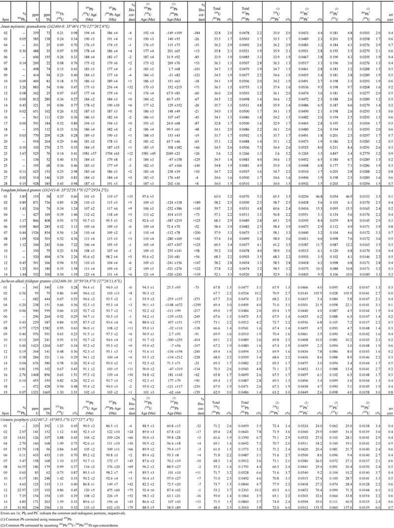
연구지역 중생대 암석의 절대연령 측정을 위해 고분해능 이차이온질량분석기(sensitive high resolution secondary ion microprobe, SHRIMP)를 이용한 저어콘 U-Pb 연대분석을 실시하였다. 분석을 위해 암석 시료를 파쇄한 후 비중선별을 하고 이후 자석으로 대자율이 높은 광물을 배제하였다. 핀셋을 이용하여 저어콘을 추려내고, 표준 저어콘과 함께 에폭시로 마운트 하였다. 한국기초과학지원연구원 오창본원의 주사 전자현미경(JEOL 6610LV)을 이용하여 저어콘 음극선발광과 후방산란전자 사진을 관찰하고 내부 구조를 파악하였다. 저어콘 U-Pb 연대분석은 Williams (1998)과 Ireland and Williams (2003)의 절차를 따랐다. 분석은 한국기초과학지원연구원 오창본원의 SHRIMP IIe를 이용하여 수행되었다. 분석을 위한 일차이온(O2-) 빔의 크기와 전류는 각각 20-25 μm(직경)와 4-6 nA였다. U 농도 측정을 위하여 SL13 저어콘이 사용되었고, U-Pb 동위원소비 측정을 위하여 FC1 저어콘이 표준시료로 사용되었다. 측정된 분석자료는 SQUID (v. 2.5)와 Isoplot (Ex 3.41) (Ludwig, 2003)을 통하여 연대가 계산되었다. 개별 분석치의 U-Pb 동위원소비와 연령은 1σ의 오차범위로 표현되었고 암석의 가중평균연대는 2σ의 오차범위로 제시되었다(표 1; 그림 2).

SHRIMP zircon U-Pb data for the Mesozoic intrusive rocks from the Jinan area.

Tera-Wasserburg concordia diagrams showing zircon igneous ages (weighted mean of 206Pb/238U age) of Mesozoic intrusive rocks: (a) Jinan mylonitic granodiorite (JA2408-8); (b) Yongdam foliated granite (JA2411-6); (c) Jucheon alkali feldspar granite (JA2408-10) and (d) granite porphyry (JA2407-2).
3.2. 연대 측정 결과
연대분석은 4개의 관입암 시료(진안 압쇄암질 화강섬록암, JA2404-8; 용담 엽리상 화강암, JA2411-6; 주천 알칼리장석 화강암, JA2408-10; 화강반암, JA2407-2)에 대해 실시하였다. 분석 결과와 시료 위치 정보는 표 1과 그림1-2에 제시되었다.
진안 압쇄암질 화강섬록암(JA2404-8)은 진안 압쇄암질 화강암류 몸체의 중남부에 자리하고 순창 전단대에 위치한다(그림 1). 이 암석의 저어콘은 주로 150-200 μm 길이의 장경을 가지는 주상(prismatic)의 결정으로 산출된다. 음극선발광사진에서 저어콘은 동심원 누대구조를 뚜렷이 보여준다. 저어콘의 Th/U 비는 0.06-2.71로 다양하게 나타나지만 전반적으로는 0.2-0.3의 범위가 우세하다. 저어콘의 206Pb/238U 연대는 194-175 Ma의 범위로 나타난다. 이 중 Tera-Wasserburg 다이아그램에서 일치도가 높고 분포가 집중된 16개의 분석점에서 획득한 206Pb/238U 가중평균연령은 184.8±1.5 Ma (MSWD=0.48)로 계산된다(그림 2a). 이 연대는 압쇄암질 화강섬록암(JA2404-8)의 화성연령에 해당한다. 다소 젊은 180-175 Ma 연령(5개 분석점)은 화강섬록암 형성 이후의 열적 사건과 관련이 있을 것으로 생각된다. 화강섬록암의 몇몇 저어콘들은 상속핵을 가지고 있는데 분석된 1개 상속핵(23번 분석점)에서는 고원생대(2049±23 Ma, 207Pb/206Pb 연대) 연령이 확인된다(표 1). 이는 화강섬록암의 주 근원물질이 고원생대 지각일 가능성을 시사한다.
용담 엽리상 화강암(JA2411-6)은 진안 압쇄암질 화강암류와 인접한 용담호 호안(lakeside)에서 채취되었다(그림 1). 이 암석의 저어콘은 주로 100-150 μm 크기의 장경을 가진 주상의 결정으로 산출된다. 음극선발광사진에서 저어콘은 동심원 누대구조를 뚜렷이 보여준다. 저어콘의 Th/U 비는 0.32-0.94로 나타난다(표 1). Tera-Wasserburg 다이아그램에서 분포가 집중된 10개의 분석점에서 획득한 206Pb/238U 가중평균연령은 109.4±2.0 Ma (MSWD=0.40)로 나타난다. 이 연대는 용담 엽리상 화강암의 화성연령에 해당한다. ~93 Ma의 연령을 보이는 두 개의 분석점은 화강암 고화 이후의 열적 사건과 관련이 있는 것으로 보인다(그림 2b). 또한 해당 연대(~93 Ma)는 주천 화강암의 형성 시기와 잘 일치한다.
주천 알칼리장석 화강암(JA2408-10) 분석 시료는 주천 화강암 몸체의 서쪽에 위치한다(그림 1). 이 암석의 저어콘은 주로 200 μm 내외 길이의 장경을 가진 주상의 결정으로 산출된다. 음극선발광사진에서 저어콘은 뚜렷한 동심원 누대구조를 보여준다. Tera-Wasserburg 다이아그램에서 군집을 이루는 16개 분석점의 206Pb/238U 가중평균연령은 93.6±0.8 Ma (MSWD=0.90)로 계산되며(그림 2c), 주천 화강암의 화성연령에 해당한다. 가중평군연령 산출에 사용된 저어콘의 Th/U 비는 0.48-1.16으로 나타난다(표 1).
화강반암(JA2407-2)은 부귀면 진안 압쇄암질 화강암류와의 인접 지역에서 채취되었다(그림 1). 화강반암의 저어콘의 크기는 100 μm 이내로 연대 분석된 시료 중 가장 작다. 저어콘은 신장성이 작은 뭉득한 모양으로 산출되고 음극선발광사진에서 동심원 누대구조를 뚜렷이 보여준다. 저어콘의 Th/U 비는 0.75-1.59로 나타난다(표 1). Tera-Wasserburg 다이아그램에서 군집을 이루는 11개 분석점의 206Pb/238U 가중평균연령은 89.0±1.4 Ma (MSWD=0.34)로 화강반암의 화성연대에 해당한다(그림 2d).
SHRIMP 저어콘 U-Pb 연대분석 결과와 현장 야외조사 결과를 바탕으로 연구지역 암상을 시대별로 나누어 설명하면 다음과 같다.
4. 고원생대 암석
4.1. 변성퇴적암류
진안군에 나타나는 변성퇴적암류의 경우 백운면 덕태산을 중심으로 NE-SW 방향으로 발달해 있다. 최근 발간된 1:100만 지질도에서는 이 지층의 남서 연장부(곡성-남원)에 해당하는 변성퇴적암에서 고생대에 해당하는 쇄설성 저어콘 U-Pb 연대가 확인된 것을 근거로 이 암체를 설옥리층으로 분류하였다(Kee et al., 2019). 그러나 진안군 백운면 일대에 분포하는 변성퇴적암류에서는 이를 뒷받침할 지질연대 자료가 직접 보고되지 않았고, 변성작용 특성을 토대로 이들이 영남육괴 기반암류로 해석 된 바 있다(Ahn et al., 1997). 그러므로 진안군 일대의 변성퇴적암류가 설옥리층에 대비되는 명확한 증거가 없어 본 논문에서는 기존 1:5만 및 1:25만 지질도에서 제시한 고원생대 지층으로 고려하였다(그림 1). 변성퇴적암류는 변성도 및 구성광물의 종류에 의해 크게 변성사암과 천매암으로 구분된다. 변성사암은 담회색을 띠며 주로 중립질의 석영으로 구성되어 있는 반면, 천매암은 변성사암에 비해 상대적으로 벽개(cleavage)의 발달이 뚜렷하며 일부 노두에서는 미소 습곡이 발달해 있다. 천매암의 주향과 경사는 각각 북동(~N35°E)과 북서(~30°NW)이다. 천매암은 세립의 석영, 흑운모, 녹니석 그리고 백운모로 구성되어 있다. 진안군 진안읍, 성수산 일대에서는 변성도가 높아져 다른 지역에 비해 운모 편암이 현저히 발달해 있다(그림 3a-3c; Ahn et al., 1997; this study). 운모 편암은 주로 흑운모, 백운모, 녹니석, 석영으로 구성되며(그림 4a), 일부 홍주석과 십자석이 관찰되어 녹니석대, 녹니석-흑운모대, 홍주석-흑운모대의 변성분대가 제시되었다(Ahn et al., 1997). 변성작용의 발생 시기는 원생누대 후기와 쥐라기로 추정되었으며 각각 영남육괴의 원생누대 광역변성작용과 쥐라기 전단운동과 관련된 것으로 해석되었다(Ahn et al., 1997). 또한 운모 편암은 쥐라기 진안 압쇄암질 화강암류 내부에서 작은 규모의 노두로도 발견되며(그림 1), 이들 편암에서는 쥐라기-백악기 연성전단운동의 변형 구조가 뚜렷하게 인지된다(그림 3a).

Representative outcrop photographs of Paleoproterozoic rocks: (a) biotite schist (Unsan-ri, Jinan-eup) showing crenulation within the Sunchang Shear Zone; (b) biotite gneiss partially interlayered with biotite schist (Seongsan-ri, Donghyang); (c) orthogneiss (amphibole (amp)-biotite (bt) gneiss) intruded by the Paleoproterozoic leucogranite (Hogye-ri, Yongdam) and (d) foliated metagranite with porphyritic texture (Sinam-ri, Baegun).
4.2. 편마암류
기존에 발간된 1:5만 지질도에 따르면 진안지역에는 다양한 선캄브리아 시대 편마암류(흑운모 편마암, 화강암질 편마암, 화강편마암, 우백질 화강편마암, 반상변정 화강편마암)가 분포하는 것으로 알려졌다(Lee and Nam, 1969; Kim and Lee, 1973; Hong and Yun, 1993). 그러나 본 연구의 야외조사 결과 용담면, 동향면, 백운면 일대에 발달한 편마암류(흑운모 편마암, 정편마암, 압쇄암질 편마암)를 제외하고 기존에 언급된 상당 부분의 암상이 변성화강암류로 확인되었으며, 일부 지역에서는 변성섬록암이 새롭게 확인되었다(Lee et al., 2019; Cho et al., 2020). 또한 이번 연구 조사에서 기존 도폭(1:5만 장기리; Lee and Nam, 1969)의 우백질 화강편마암과 화강암질 편마암의 상당 부분이 백악기 화강암류(용담 엽리상 화강암)로 확인된다(그림 1). 흑운모 편마암은 편마리가 뚜렷이 발달하며 부분적으로 흑운모 편암과 교호하며 나타나기도 한다(그림 3b). 편마리의 주향은 N80°E 방향이 우세하고 경사는 남동(45°SE) 방향이 우세하다. 편마암은 중립질 내지 조립질의 석영, 장석, 흑운모로 구성되고(그림 4b), 부분 용융에 의한 우백질대(leucosome)가 잘 발달하여 있으며 부분적으로 변성사질암이 잔류체 형태로 나타난다. 정편마암은 전반적으로 담회색을 띠고 편마리를 보이며 우백질 화강암에 의해 관입된 구조를 보인다(그림 3c). 편마리의 주향은 동남동(ESE) 방향이 우세하고 경사는 북동(65°NE) 방향이 우세하다. 정편마암은 중립질 내지 조립질의 석영, 사장석, 정장석, 흑운모, 녹니석, 녹염석으로 구성되고 부구성 광물로는 방해석과 스핀이 나타난다. 부분 용융에 의해 형성된 우백질대의 연변부를 따라 흑운모 셀비지(selvedge)가 관찰된다. 일부분에서는 엽리를 관통하는 미소 균열이 관찰되며, 미소 균열을 따라 방해석, 녹니석 및 녹렴석과 같은 변질광물이 관찰되며 일부 장석류는 견운모화작용을 받았다.
압쇄암질 편마암은 백운면 일대에서 호남전단대를 따라 NE-SW 방향으로 배열되며 압쇄엽리의 주향은 NE 내지 북북동(NNE) 방향이 우세하다. 압쇄암질 편마암은 후술할 진안 압쇄암질 화강암류(쥐라기)와 함께 연구지역의 호남전단대 범위를 잘 보여주고 있다(그림 1).
4.3. 변성화강암류 및 변성섬록암
변성화강암류(변성화강암, 변성우백질 화강암, 변성반정질 화강암)에서는 등립질 조직이 우세하게 발달해 있지만 부분적으로 반상조직이 나타나기도 한다. 또한 지역에 따라 후기에 발생한 변형 혹은 변성작용에 의한 엽리 및 압쇄조직이 관찰되기도 한다(그림 3d; Lee et al., 2019). 각 변성화강암류의 암상경계가 명확하지 않고 이들의 지화학 조성 또한 뚜렷이 구분되지 않으므로 이들을 하나의 변성화강암류로 설정하였다. 변성화강암류 중 변성화강암과 변성반정질 화강암은 주로 흑운모, 정장석, 사장석, 석영으로 구성되며(그림 4c), 변성우백질 화강암은 주로 정장석, 석영과 소량의 사장석과 백운모가 관찰된다. 한편, 변성섬록암은 주로 등립질 조직을 보이고 후기 변질작용에 의해 형성된 녹염석 노듈이 산발적으로 발달해 있다. 변성화강암류와 변성섬록암의 저어콘 U-Pb 연대측정 결과, 이들 암체는 대략 2000-1960 Ma에 형성되었고 약 1880-1860 Ma에 변성작용을 경험하였다(Oh et al., 2016; Lee et al., 2019; Cho et al., 2020).

Photomicrograph of Paleoproterozoic rocks: (a) mica schist (cross polarized light, xpl); (b) biotite gneiss (plane polarized light; ppl); (c) metagranite (xpl) and (d) amphibolite (ppl). Abbreviation: hbl, hornblende; ms, muscovite; op, opaque mineral; or, orthoclase; pl, plagioclase; qtz, quartz; sill, sillimanite.
4.4. 각섬암(시대 미상)
시대 미상의 각섬암이 진안군 남쪽 끝 백운면 성수산 일대에 나타난다(그림 1). 이 암체는 엽리를 간직한 보통각섬석+사장석+석영 조합의 변성암으로(그림 4d) 변성퇴적암류(편암) 및 고원생대 화강암(변성화강암)과 함께 변형되어 나타난다. 엽리의 주향은 NE-SW 방향이 우세하다. 1:5만 오수도폭에서는 이 암체의 지질시대를 인접한 엽리상 화강섬록암과 같이 시대 미상으로 설정하였고(Kim et al., 1984), 반면에 1:25만 광주도폭은 엽리상 화강섬록암과 쥐라기의 동일 시기로 보았다(Lee et al., 1997). 그러나 각섬암은 변성암으로써 쥐라기 엽리상 화강섬록암(화성암)과 같은 시기일 수 없다. 이 암석(각섬암)이 경험한 각섬암상의 변성작용은 쥐라기 이전으로 생각된다. 함께 변형된 고원생대 암체들과 조화적인 엽리 배열을 보이는 것으로 보아 각섬암은 고원생대 암석들과 같은 변성작용을 경험한 것으로 생각된다. 각섬암의 원암 연령은 원생누대로 추정된다.
5. 신원생대-고생대 암석
옥천층군의 암석들이 연구지역 북서쪽 금산군, 완주군 일대에 NE-SW 방향으로 넓게 나타난다. 연구지역에서 옥천층군 암석은 진안군 북쪽 끝 주천면 무릉리 일대에서 소규모로 나타나는 마전리층이다(그림 1). 마전리층은 석회규산염암과 대리암으로 구성된다(Hong and Choi, 1978; Lee et al., 1996). 기존 연구에서 옥천층군의 형성 시기가 신원생대에서 고생대 사이로 평가되므로(Lee et al., 1998; Lim et al., 2005; Choi et al., 2012; Cho et al., 2013), 본 연구에서는 마전리층의 지질시대를 신원생대-고생대로 설정하였다.
6. 중생대 암석
6.1. 쥐라기 관입암류
압쇄엽리를 가진 화강암류가 진안군을 NE-SW 방향으로 가로지르며 발달한다. 이 암체는 압쇄암질 화강암 및 압쇄암질 화강섬록암으로 이 연구에서는 진안 압쇄암질 화강암류로 명명한다(그림 1). 이 암체는 1:5만 진안도폭에서 선캄브리아 화강편마암으로 기재되었으며(Shimamura, 1924), 이후 1:100만 한국지질도에서는 시생누대 화강편마암으로(Choi, 1995), 1:25만 광주도폭에서는 쥐라기 엽리상 화강암으로 정정되었다(Lee et al., 1997). 그럼에도 불구하고 암체에 대한 절대연령 보고가 없으며 주변의 선캄브리아 편마암과 구분되지 않은 상태로 분포가 확정 되지 않았다. 본 연구에서 획득된 진안 압쇄암질 화강암류의 저어콘 U-Pb 연대는 185±2 Ma로 쥐라기 화성연령을 보인다(그림 2a). 해당 암체에서는 주로 북북동(NNE)-남남서(SSW) 주향의 압쇄엽리가 발달하는데(그림 5a, 5b), 이는 호남전단운동과 진안분지 형성과 관련된 백악기 전단운동의 복합적인 결과로 추정된다. 진안 압쇄암질 화강암류는 흑운모 화강암, 화강섬록암, 각섬석-흑운모 화강암, 우백질 화강암으로 구성된다. 이 중 흑운모 화강암이 가장 넓은 분포를 보인다. 흑운모 화강암은 장석류(사장석, K장석)가 반상쇄정(porphyroclast)으로 나타나고 재결정화된 석영이 압력 그늘을 차지하며, 흑운모, 스핀, 녹염석 등이 엽리를 따라 배열된다(그림 6a). 부귀면 일대에서 확인되는 동(E)-서(W) 방향으로 발달된 화강암질 암체의 일부도 진안 압쇄암질 화강암류에 해당한다. 이 화강암질 암체는 선캄브리아 혹은 시생누대 화강편마암(Shimamura, 1924; Choi, 1995), 쥐라기 엽리상 화강암(Lee et al., 1997)으로 기재된 바 있으며, 최근 1:100만 한국지질도에서는 백악기 화강암으로 보고되었다(Kee et al., 2019). 부귀면 일대의 화강암질 암체는 세 종류로 구분된다. 동쪽부의 엽리상 화강암은 쥐라기 진안 압쇄암질 화강암류에 해당한다. 서쪽부의 비변형 화강암질암은 백악기 반암류(화강반암)에 해당한다. 백악기 용담 엽리상 화강암이 부귀면 가장 동쪽 두남리 일대에서 소규모로 나타난다(그림 1). 백운면 일대의 NE-SW 방향으로 발달한 편마리 화강암질 암체는 고원생대 암석(압쇄암질 편마암)으로 분류된다. 기존 지질도는 이 암체를 선캄브리아 혹은 시생누대 화강편마암(Shimamura, 1924; Choi, 1995), 최근의 지질도는 쥐라기 엽리상 화강암으로 기재하였다(Lee et al., 1997; Kee et al., 2019). 그러나 현장 조사 결과 백운면의 압쇄암질 암체는 편마암에 해당하며 진안 압쇄암질 화강암류와는 형태적·시기적으로 뚜렷이 구분된다. 1:25만 광주도폭과 1:100만 한국지질도에서는 진안 압쇄암질 화강암류와 남서부의 쥐라기 순창화강암(압쇄암질)이 NE-SW 방향으로 연결되어 구분을 짓기 힘든 것으로 보여진다(Lee et al., 1997; Kee et al., 2019). 그러나 두 암체 사이에는 고원생대 편마암(압쇄암질 편마암)이 존재하므로 진안 압쇄암질 화강암류와 순창화강암은 지질학적으로 구분될 수 있다(그림 1).

Representative outcrop or thin section photographs of Jurassic intrusive rocks: (a, b) Jinan mylonitic granodiorite with NE-SW striking foliation (JA2404-8; Banwol-ri, Jinan-eup); (c) foliated granodiorite (Sinam-ri, Baegun) with NE-SW striking foliation and (d) biotite granite (Songpung-ri, Yongdam). The 020°and 200°orientations in (b) indicate the maximum stretching directions of the Jinan mylonitic granodiorite. Abbreviation: MME, mafic microgranular enclave.

Photomicrograph of Mesozoic intrusive rocks: (a) Jinan mylonitic granite (xpl); (b) Yongdam foliated granite (xpl); (c) Jucheon alkali feldspar granite (ppl) and (d) granite porphyry (ppl). Abbreviation: fds, feldspar.
엽리상 화강섬록암의 상당 부분은 장수군 지역에 나타나며 진안쪽 관입암체는 백운면 남동부 끝에 나타난다(그림 1). 진안지역 관입암체는 보통각섬석과 흑운모를 포함하는 화강섬록암으로써 고원생대 암체(변성화강암류, 각섬암)를 관입한다. 엽리상 화강섬록암은 동시기로 생각되는 고철질 미립 포유암을 간직한다(그림 5c). 엽리상 화강섬록암은 주로 NE-SW 주향 및 NW 경사 방향을 갖는 엽리를 가지며, 절대연령 자료는 보고되지 않았다. 1:5만 오수도폭에서는 해당 암체가 시대 미상으로(Kim et al., 1984), 1:25만 광주도폭과 최근 발간된 1:100만 한국지질도에서는 쥐라기로 기재되었다(Lee et al., 1997; Kee et al., 2019).
진안군 북쪽 용담면 일대에 엽리가 없거나 엽리 발달이 미약한 중립질 흑운모 화강암이 나타난다(그림 1, 5d). 이 암체는 금산군 영역으로 뻗어 있으며 진안 압쇄암질 화강암류와의 지질학적 관계는 불명확하다. 흑운모 화강암에서 압쇄엽리가 발달하지 않는 것으로 보아 이 암체의 영역은 호남전단대에서 벗어나 있는 것으로 추정된다. 이 암체는은 1:5만 장기리 도폭에서는 선캄브리아 편암류(Lee and Nam, 1969)로, 1:25만 광주도폭에서는 선캄브리아 편암류와 쥐라기 흑운모 화강암이 보고되었다(Lee et al., 1997).
주천면 북서쪽에 엽리가 없거나 엽리 발달이 미약한 복운모 화강암이 소규모 암주로 나타난다(그림 1). 이 암체는 옥천층군 마전리층을 관입하고 있으며, 금산군 쪽에 복운모 화강암이 추가적으로 더 존재할 가능성이 있다. 복운모 화강암은 1:5만 금산도폭에서 쥐라기 암체(흑운모 화강암)로 기재되었다(Hong and Choi, 1978). 복운모 화강암이 진안 압쇄암질 화강암류 및 흑운모 화강암과 어떠한 지질학적 관계에 놓여 있는지는 분명치 않다.
6.2. 백악기 관입암류
압쇄엽리를 간직한 흑운모 화강암이 용담호 주변 용담면-안천면 일대에서 관찰되며 부귀면 두남리 일대에서도 소규모 암주로 확인된다(그림 1). 본 연구에서 암체의 화성연령은 백악기(109±2 Ma)로 확인되고(그림 2b) 용담 엽리상 화강암으로 명명한다. 용담 엽리상 화강암은 쥐라기 진안 압쇄암질 화강암류에 비해 엽리 발달이 미약하고, 압쇄엽리는 주로 동남동(ESE)-서북서(WNW) 주향을 보여준다(그림 7a). 엽리상 화강암에서는 K장석 반정이 나타나고 사장석과 함께 반상쇄정으로 산출된다(그림 6b, 7a). 암체의 대부분은 진안분지 퇴적암과 직접 접촉하지는 않으며, 부귀면 암주는 산수동층과 단층접촉을 하고 있다. 용담 엽리상 화강암은 진안분지의 기반암에 해당하는 것으로 추론된다.

Representative outcrop and rock slab (or thin section chip) photographs of Cretaceous intrusive rocks: (a) Yongdam foliated granite with ESE-WNW striking mylonitic foliation (Baekhwa-ri, Ancheon); (b) Jucheon alkali feldspar granite (JA2408-10; collected from the Yongduk-ri, Jucheon); (c) Unjangsan alkali feldspar granite (collected from the Daebul-ri, Jucheon) and (d) granite porphyry (JA2407-2; Guoseok-ri, Bugwi) hosting intermediate microgranular enclaves. Abbreviation: Kfs, K-feldspar.
진안군 북부 주천면 일대에 알칼리장석 흑운모 화강암이 나타난다(그림 1). 본 연구는 주천면-용담면 사이의 알칼리장석 흑운모 화강암을 주천화강암이라 명명한다. 주천화강암은 엽리가 없거나 발달이 미약하며 중립질의 정장석, 석영, 사장석, 흑운모로 구성된 등립상 조직을 보인다(그림 6c, 7b). 주천화강암은 금산군, 무주군 쪽으로 연장되는 것으로 추정되나, 진안군 너머의 북쪽 경계는 확인하지 못하였다. 주천화강암 연령은 이번 연구를 통해 94±1 Ma로 확인되며(그림 2c), 이것은 주천화강암이 진안분지 퇴적암 보다 오래된 암석임을 지시한다.
진안군 북부 운장산 권역에서도 알칼리장석 흑운모 화강암이 나타난다(그림 1). 이 암체는 엽리가 발달되지 않으며 완주군 영역으로 뻗어 있다(그림 7c). 이 암체의 연령은 확인된바 없으나 1:5만 용담 도폭에서는 주천화강암과 같은 시기로 제시되었다(Kim and Lee, 1973). 본 논문에서는 운장산 권역의 알칼리장석 흑운모 화강암을 운장산 화강암으로 명명하고, 암체의 형성 시기를 주천화강암과 유사한 백악기로 판정하였다.
중성질-규장질 반암류가 진안군 전반에 걸쳐 확인되며, 화강반암이 주류를 이룬다. 이들은 고원생대 암체, 쥐라기 화강암류, 백악기 화강암류와 진안층군을 관입한다(그림 1). 이들은 암주 내지 암맥의 형태로 관입하고 일부 암체는 암상(sill)의 형태를 보인다. 가장 규모가 큰 암체는 부귀면에서 확인되는 화강반암이다. 부귀면 화강반암은 중성질 미립포유암을 내포하며 동시기성 중성질 화성활동을 지시한다(그림 7d). 부귀면 화강반암의 관입연령은 89±1 Ma로 확인된다(그림 2d). 연대 분석된 화강반암은 보통각섬석과 장석류를 반정으로 갖고 전반적으로 열수 변질된 양상을 간직한다(그림 6d). 진안군 남서쪽 성수면 일대에서는 중성질 반암류가 분포하며 임실군 영역에서 획득된 현무암질 조면안산반암의 저어콘 U-Pb 연대는 85±1 Ma로 보고되었다(Lee, S.H. et al., 2020).
6.3. 백악기 퇴적암 및 화산암류
연구지역의 퇴적암류는 백악기 진안분지를 충진한 진안층군의 북동부에 해당한다(그림 1). 진안분지의 기반암은 선캄브리아(고원생대) 편마암 및 편암류, 쥐라기-백악기 화강암류로 구성된다. 분지는 백악기 주향이동 전단운동대 중 광주단층계(광주단층, 순창단층) 상에 발달하였다. 진안층군은 육성분지로, 충적 및 호소퇴적환경이 우세하다(Lee, 1992; Lee and Chough, 1999). 퇴적 시기는 식물화석 파편 및 화분 분석에 근거하여 약 129-113 Ma로 추정되어 왔으나(Chang, 1975; Reedman and Um, 1975; Yi et al., 1998), 진안층군 내 산수동층 및 달길층 사암의 쇄설성 저어콘 U-Pb 연대로 제한한 최대퇴적연대가 각각 약 98 Ma, 90 Ma로 확인되었고, 협재하는 화산암의 연대가 92-89 Ma로 보고됨에 따라 진안층군의 퇴적 시기는 후기 백악기로 여겨질 수 있다(Lee, 2017; Lee, S.H. et al., 2020). 또한 주천화강암(94±1 Ma), 달길층, 화산암류, 화강반암(89±1 Ma)의 상호관계를 볼 때 연구지역 진안층군의 주 퇴적 시기는 92-89 Ma 시기로 제한될 가능성이 있다.
진안층군은 암상에 따라 산수동층(이암상, 흑색 및 암회색 이암과 사암상), 마이산역암(역암상), 달길층(이암상, 응회암, 흑색 및 응회질 셰일), 만덕산층(사암상, 역암, 흑색셰일, 안산암, 응회질셰일, 응회암, 이암)으로 세분된다(그림 8a-8d; Shimamura, 1924; Lee, 1992). 이들 간의 층서적 선후 관계는 여러 차례 제안된 바 있으며(e.g., Shimamura, 1924; Son, 1969; Kim and Lee, 1973; Chang, 1975), 최근 많은 연구에서는 이들을 동시기 층으로 해석한 Lee, Y.Y. (1992)의 층서를 따른다(그림 9). 즉 분지 가장자리의 단층대 주변에는 역암 및 사암이 우세한 충적선상지 및 선상지삼각주 등의 퇴적환경에서 마이산역암 및 만덕산층이 형성되었으며, 분지 중앙부에서는 셰일 또는 이들과 교호하는 사암 및 실트암이 우세한 호소 환경의 산수동층과 달길층이 형성되었다는 해석이다(Oh et al., 2016, 2017; Lee, 2017; Lee, S.H. et al., 2020).

Representative field photographs illustrating key sedimentary features of the Jinan Group: (a) clast-supported, bouldery conglomerate (Maisan Conglomerate) exhibiting tafoni structures (dashed lines), exposed at the Mt. Maisan geosite; (b) crudely stratified conglomerate (Cg) and gravelly sandstone (gSS) of the Maisan Conglomerate (Pyeongjang-ri, Baegun); (c) Gilbert-type deltaic geometry displaying topset, foreset and bottomset sequences at the Ungyo-ri Fan Delta geosite, at the contact between the Maisan Conglomerate and Sansudong Formation and (d) laminated sandstone-mudstone (SS-MS) couplets characteristic of the Sansudong Formation (Yeonjang-ri, Jinan-eup).

Comparison of previously proposed stratigraphic frameworks for the Jinan Basin.
Lee, Y.Y. (1992)는 이러한 층들의 수평적 인접성을 기본 가정으로 하여, 진안층군의 퇴적암상을 충적선상지, 선상지삼각주, 선상지평원 및 호소 환경을 나타내는 퇴적상 조합으로 제안하였다. 또한 지역적으로 인지되는 상향조립화를 근거로 분지가 구조적으로 크게 두 번 확장되었다고 해석하였다. 한편 Lee and Chough (1999)는 진안분지의 동부 마이산역암층 및 산수동층의 전이지대 인근에서 보다 상세한 퇴적상 분석을 수행하여 퇴적상 조합을 충적선상지, 소규모 길버트형 삼각주, 가파른 삼각주 사면, 삼각주 사면의 기저부 또는 삼각주 전면, 호수 중앙부 등으로 세분하였으며, 차별적 분지 침강에 따른 순차적 퇴적상의 변화 및 전진발달 과정을 해석하였다.
진안층군 퇴적암의 화분/포자 변색도(palynomorphs colors) 및 일라이트 결정도 분석 결과, 진안분지는 약 200-300℃ 이상의 온도를 경험한 것으로 추정되었다(Yi et al., 1998; Choi and Lee, 2011). 이는 진안층군의 두께를 약 1.5 km로(Baag and Kwon, 1994), 백악기 동안 한반도의 비교적 높은 지온구배율(약 35℃/km; Lim and Lee, 2005)을 가정하고 계산한 진안층군의 하부 온도인 약 70℃를 크게 상회하며, 진안분지가 화산활동의 영향을 크게 받아 나타난 결과로 해석된다. 진안층군 내에는 다양한 종류의 화산암이 협재하며, 이들 내 저어콘 U-Pb 연령(약 90 Ma)은 퇴적암 내 쇄설성저어콘의 최소연령(약 90 Ma)과 매우 유사하다(Lee, S.H. et al., 2020). 더불어 분지 중앙 및 주변부 임실군에 분포하는 현무암질 조면안산반암과 유문암의 연대가 약 85 Ma로 보고되어(Lee, S.H. et al., 2020), 분지의 충진 및 그 이후에도 진안분지가 지속적인 화성활동의 영향을 받았음이 확인된다.
진안지역의 화산암은 안산암질-유문암질 화산암으로 응회암을 포함하며, 주로 유문암 및 유문암질 응회암이 우세하게 산출된다. 화산암류는 성분상으로 반암류의 구성과 유사하다. 화산암류는 진안군 북쪽 지역(구봉산-운일암반일암 일대; 용암류 우세)과 동쪽 지역(천반산 일대; 화산쇄설암 우세)에서 주로 나타나고 진안층군 퇴적 이후에 형성된 것으로 보고되었다(Kim and Lee, 1973; Lee, 1992). 그러나 진안층군 내 도처에서 쇄설성 퇴적암에 협재된 화산암이 확인된다. 진안층군에 협재된 유문암의 저어콘 U-Pb 연령(89±0.2 Ma, 90±0.4 Ma; Lee, S.H. et al., 2020)과 진안층군 북쪽 유문암의 저어콘 U-Pb 연령(90±0.4 Ma; Lee, 2017)이 동일하게 나타나므로(그림 1), 진안층군은 퇴적 당시 화산활동의 영향권에 있었으며 퇴적물 충진 이후에도 지속적인 화산활동의 영향으로 용암과 화산쇄설물로 피복되었을 것으로 추정된다. 또한 진안층군 형성 시 화산활동과 후기 화산활동 간 지질학적 시간차가 크지 않은 것으로 추정된다.
8. 토 의
진안지역에 대한 본 연구결과와 기존 연구를 종합하여 연구지역에서 일어난 지구조운동을 다음과 같이 해석하였다.
8.1. 진안지역의 원생누대
최근 연구에 따르면 진안과 무주지역에서 주목할 만한 새로운 지질학적 사건은 고원생대 오로세이라기(Orosirian, 2000-1960 Ma)에 발생한 화성활동이다(그림 10; Lee et al., 2019). 이 화성활동으로 인해 진안지역에서는 변성화강암류, 변성섬록암과 정편마암류의 원암이 형성되었다. 암석지화학분석과 동위원소 분석 결과에 의하면 이 암체들은 맨틀의 진화/부분용융을 통해 형성되기보다는 대부분 기존에 존재하던 지각물질의 부분용융에 의해 형성된 것으로 추정된다. 또한 이 암체들은 지구조환경 관점에서 화산호 환경에서 형성되었다(그림 11; Lee et al., 2019; Cho et al., 2020). 이러한 지구연대학적, 암석지구화학적 특징은 영남육괴 북동부에 분포하는 고원생대 화강암류(예: 분천화강암 및 홍제사화강암)와 유사하다(Lee et al., 2019, 2023; Kim et al., 2021, 2026). 이는 영남육괴 북동부의 고원생대 변성화성암류를 형성시킨 화산호 관련 화성활동이 진안 일대까지 발생했었음을 의미한다. 이들 고원생대 화성기원암은 약 1880-1860 Ma경에 변성작용을 경험한 것으로 보고되었으나(그림 10; Lee et al., 2019), 변성작용의 특성을 추정할 수 있는 광물군의 부재로 이들의 정확한 변성조건을 규명하기는 어렵다. 다만 이들 암체에서 확인된 변성연대(1880 -1860 Ma)가 진안 인접 지역인 무주에서 보고된 고원생대 고온-저압형 변성작용 시기와 일치한다는 점을 고려할 때, 진안 지역의 변성화성암류와 정편마암류 역시 무주지역에서 확인된 것과 유사한 조건에서 변성작용을 경험한 것으로 추정된다(Oh et al., 2013; Lee, B.C. et al., 2020). 한편 변성화강암에서 확인되는 고생대 후기 혹은 중생대 전기의 2차 변성작용(261±39 Ma)은 진안지역 전반의 현생누대 변성작용에 대한 단서를 제공하고 있다(그림 10; Lee et al., 2019).
진안군의 암석 연령 분포는 쥐라기 화강암류(진안 압쇄암질 화강암류, 흑운모 화강암)를 중심으로 그 동쪽으로 고원생대 암석과 서쪽으로 옥천층군 암석(신원생대-고생대)으로 구분될 수 있다(그림 12). 본 연구에서 제시하는 새로운 지질도는 호남전단대(순창전단대)를 중심으로 영남육괴와 옥천변성대가 구분될 가능성을 제안한다(그림 12, 13).

Wetherill concordia diagrams showing zircon igneous and metamorphic ages of Paleoproterozoic meta-igneous rocks: (a) porphyritic metagranite and (b) metadiorite. Data are from Lee et al. (2019).

Binary classification diagrams for Paleoproterozoic meta-igneous rocks: (a) total alkali-SiO2 plutonic rock classification diagram; (b) tectonic discrimination diagram; (c) diagram illustrating petrogenetic processes and (d) diagram showing results of zircon Lu-Hf isotope analyses. Data are from Lee et al. (2019) and references therein. Abbreviations: CH, concentration of highly incompatible element; CM, concentration of moderately incompatible element.

Distribution of major lithologies in the Jinan area and the extent of the Honam Shear Zone (Sunchang Shear Zone).

View from Mt. Bugwisan through Mt. Maisan toward Mt. Seongsusan, showing various lithologies and the Sunchang Shear Zone of the Jinan area. Locations and lithologies are indicated in Figs. 1 and 12.
8.2. 진안지역의 중생대
호남전단대는 한반도 남서부로부터 NE 내지 NNE 방향으로 발달한 연성전단대로 영남육괴와 옥천변성대의 암석을 변형시키고 있고 전남 목포에서 경북 울진까지 연장된다(Yanai et al., 1985; Cluzel et al., 1991; Kwon and Ree, 1997; Cheong, 1998). 호남전단대는 영광전단대, 광주전단대, 순창전단대, 전주전단대, 예천전단대로 지역적으로 나뉘는데(Cheong, 1998), 진안지역에 대한 전단대 연구는 전무하다. 진안지역 호남전단대(순창전단대) 영역은 진안 압쇄암질 화강암류의 분포지와 그 남동부에 발달한 압쇄암질 편마암 지대에 해당한다(그림 12, 13). 이들 지역의 암석들은 주로 NNE-SSW 주향의 압쇄엽리를 간직하고 주향방향에 평행하거나 아평행한 방향성의 광물 신장구조를 보인다. 진안군 북동부에서는 압쇄암화된 암체가 발견되지 않는데 이것은 순창전단대가 백악기 암체에 의해 가려진 결과로 판단된다. 전단대 내 암석의 전단감각은 뚜렷하게 한 방향으로 정의되기 힘들 정도로 여러 단계의 전단운동을 경험한 것으로 보여진다. 진안 압쇄암질 화강섬록암(JA2404-8)의 화성연대(185±2 Ma)는 호남전단운동의 주 활동 시기가 185 Ma 이후임을 지시하나, 185 Ma 이전의 호남전단운동의 가능성도 배제할 수는 없다. 연구지역 쥐라기 호남전단운동의 완료 시기는 불분명하지만 Kwon and Ree (1997)는 남원화강암(176±3 Ma, 열이온화질량분석 저어콘 U-Pb; Turek and Kim, 1995)이 호남전단운동과 동시기에 형성되었음을 지지하였다. 또한 이 시기(176±3 Ma)가 호남 전단운동의 최종 운동(우수향 연성전단운동) 시기일 가능성을 제시하였다. 이후 SHRIMP 저어콘 U-Pb 연대분석 결과는 남원화강암의 고화연령이 ~190 Ma에서 ~180 Ma로 보고된다(Jo et al., 2013; Choi and Kim, 2023). 한편 순창전단대에 포함된 순창 압쇄암질 화강암의 SHRIMP 저어콘 U-Pb 연대(화성 연령)는 ~185 Ma에서 ~175 Ma로 보고된다(Jo et al., 2013; Choi and Kim, 2023). 그러므로 순창전단대의 쥐라기 호남 전단운동은 ~175 Ma 시기에도 계속되고 있었을 것으로 추론된다. 진안지역 순창전단대에서 호남전단운동의 활동 시기를 명확하게 한정하기 위해서는 변형 동시성 광물, 변형 이후 형성된 광물에 대한 절대 연령자료의 축적이 필요하다.
용담 엽리상 화강암(109±2 Ma)에는 ESE-WNW 주향의 압쇄엽리가 발달하며, 광물 신장 방향은 압쇄엽리의 주향에 평행하거나 아평행하다. 즉 진안지역의 북동부 내지 중부지역은 백악기에 연성전단운동을 경험한 것으로 판단된다. 반면에 주천화강암(94±1 Ma)에서는 압쇄엽리가 발견되지 않는다. 즉 109-94 Ma 시기에 진안지역에서는 연성전단운동(ESE-WNW 주향이동)이 발생하였으며 이것은 NNE-SSW 방향의 주향이동 전단운동과 함께 백악기 진안분지 형성에 간접적으로 관여된 변형작용으로 생각된다.
결과적으로, 진안분지 퇴적암(달길층)에서 확인되는 94 Ma 쇄설성 저어콘 연대(Oh et al., 2017)는 진안분지가 주천화강암(94±1 Ma) 형성 이후에 발달했다는 것을 지시한다. 진안층군(달길층)을 관입하는 연구지역 화강반암(JA2407-2)의 연령이 89±1 Ma로 나타나므로 진안층군의 퇴적은 89±1 Ma 이전에 완료되었을 것으로 추론된다. 또한 진안층군 퇴적암에 협재된 화산암과 피복하는 화산암의 저어콘 U-Pb 연령은 각각 92-89(±<1) Ma (Lee, 2017; Lee, S.H. et al., 2020)와 90±0.4 Ma (Lee, 2017)로 나타난다. 이는 연구지역 진안분지의 퇴적물 충진이 주로 92-89 Ma 시기에 발생했음을 지시한다.
9. 결 론
이상의 연구 결과로부터 다음의 결론을 얻을 수 있다. 호남전단대(순창전단대)를 기준으로 진안군의 동쪽은 주로 고원생대 암체로 구성되며 영남육괴에 해당하고, 서쪽은 옥천층군 마전리층의 존재에 의해 옥천변성대에 해당한다. 순창전단대는 고원생대 편마암과 중생대(쥐라기) 진안 압쇄암질 화강암류(185±2 Ma 화성연령)를 NE-SW 방향으로 관통하고 연구지역 북동부에서는 백악기 암체에 가려진다. 용담 엽리상 화강암(109±2 Ma 화성연령)은 백악기 중기의 화성활동과 이후의 백악기 연성전단운동의 결과로 형성되었다. 주천화강암(94±1 Ma)은 진안층군 퇴적암 보다 오래된 연령을 보여주고 엽리가 발달하지 않는다. 이는 백악기 연성전단운동이 109-94 Ma 사이에 일어났음을 지시한다. 화강반암(89±1 Ma)은 진안층군 퇴적암(달길층)을 관입하고 진안층군 퇴적시기의 하한을 규정하며 기존 연구결과와 함께 진안분지의 퇴적작용이 92-89 Ma 사이에 일어났음을 지시한다.
Acknowledgments
이 연구는 진안군 지질명소 가치 발굴 용역 과제(2025-0734-01)의 지원을 받았다. 저어콘 연대측정은 한국기초과학지원연구원의 전문연구지원과제(고분해능 이차이온질량분석기, SHRIMP) 분석으로 수행되었다. 저자는 야외조사와 자료 정리에 도움을 준 강민수 석사와 권예원, 황민정, 주현홍 그리고 전북대학교 퇴적시스템연구실, 암석학연구실 학생들에게 고마움을 전한다. 또한 저어콘 연대분석에 도움을 준 한국기초과학지원연구원의 이신애 연구원과 논문 리뷰 과정에서 건설적인 비평을 준 편집위원장, 편집위원, 심사위원들께 감사드린다.
References
- Ahn, K.S., Kim, Y.J. and Shin, I.H., 1997, Metamorphism of the meta-sedimentary rocks in the Osu-Jinan area, Cheonrapuk-do, Korea. The Korean Society of Economic and Environmental Geology, 30, 163-174 (in Korean with English Abstract).
-
Baag, C.-E. and Kwon, B.D., 1994, Geophysical studies on major faults in the Ogcheon Fold Belt: Aeromagnetic data interpretation on the Jinan sedimentary basin, Korea. Korean Journal of Petroleum Geology, 2, 33-38.
[https://doi.org/10.14770/jgsk.1994.30.2.193]

-
Chang, K.H., 1975, Cretaceous stratigraphy of southeast Korea. Journal of the Geological Society of Korea, 11, 1-23.
[https://doi.org/10.14770/jgsk.1975.11.1.1]
- Chang, K.H., 1985, Geology of Korea. Mineumsa Publishing Co., 270 p (in Korean).
- Cheong, C.H., 1998, Geology of Korea. Sigma Press, Seoul, 802 p (in Korean).
-
Cho, D.-L., Lee, B.C. and Oh, C.W., 2020, Petrogenesis of paleoproterozoic (2.02-1.96 Ga) metagranitoids in the southwestern Yeongnam Massif, Korean Peninsula, and their significance for the tectonic history of northeast Asia: Insights from zircon U-Pb-Hf isotope and whole-rock geochemical compositions. Precambrian Research, 340, 105631.
[https://doi.org/10.1016/j.precamres.2020.105631]
-
Cho, M., Cheong, W., Ernst, W.G., Yi, K. and Kim, J., 2013, SHRIMP U-Pb ages of detrital zircons in metasedimentary rocks of the central Ogcheon fold-thrust belt, Korea: Evidence for tectonic assembly of Paleozoic sedmentary protoliths. Journal of Asian Earth Sciences, 63, 234-249.
[https://doi.org/10.1016/j.jseaes.2012.08.020]
-
Choi, D.K., Woo, J. and Park, T.Y., 2012, The Okcheon Supergroup in the Lake Chungju area, Korea: Neoproterozoic volcanic and glaciogenic sedimentary successions in a rift basin. Geosciences Journal, 16, 229-252.
[https://doi.org/10.1007/s12303-012-0031-6]
-
Choi, S.H. and Kim, J.-I., 2023, Emplacement ages and petrogenesis of the Sunchang and Namwon granitoids, South Korea. Lithos, 444-445, 107107.
[https://doi.org/10.1016/j.lithos.2023.107107]
-
Choi, T. and Lee, Y.I., 2011, Thermal histories of Cretaceous basins in Korea: Implications for response of the East Asian continental margin to subduction of the Paleo-Pacific Plate. Island Arc, 20, 371-385.
[https://doi.org/10.1111/j.1440-1738.2011.00771.x]
- Choi, W., 1995, Geological map of Korea (1:1,000,000), Korea Institute of Geology, Mining and Materials (in Korean).
-
Cluzel, D., Jolivet, L. and Cadet, J.-P., 1991, Early middle Paleozoic intraplate orogeny in the Ogcheon Belt (South Korea): A new insight on the Paleozoic buildup of east Asia. Tectonics, 10, 1130-1151.
[https://doi.org/10.1029/91TC00866]
- Hong, S.H. and Choi, W., 1978, Geological report of the Geum San sheet (1:50,000). Korea Research Institute of Geoscience and Mineral Resources, 29 p.
- Hong, S.H. and Yun, W., 1993, Geological report of the Changkye sheet (1:50,000). Korea Institute of Geology, Mining and Materials, 17 p.
-
Ireland, T.R. and Williams, I.S., 2003, Considerations in zircon geochronology by SIMS. In Zircon (eds. Hanchar, J.M. and Hoskin, P.W.O.), Reviews in Mineralogy and Geochemistry, Mineralogical Society of America, 53, 215-241.
[https://doi.org/10.2113/0530215]
-
Jo, H.J., Park, K.-H. and Yi, K., 2013, SHRIMP U-Pb ages of the Namwon and Sunchang granites. The Journal of Petrological Society of Korea, 22, 197-208 (in Korean with English Abstract).
[https://doi.org/10.7854/JPSK.2013.22.2.197]
- Kang, J.-H., 2010, Deformation structures of the Jurassic Ogcheon granite and the Honam shearing, Ogcheon area, Korea. The Journal of the Petrological Society of Korea, 19, 19-30 (in Korean with English Abstract).
-
Kee, W.S. and Kim, J.H., 1992, Shear creteria in mylonites from the Soonchang Shear Zone, the Hwasun Coalfield, Korea. Journal of the Geological Society of Korea, 28, 426-436 (in Korean with English Abstract).
[https://doi.org/10.14770/jgsk.1992.28.4.426]
- Kee, W.S., Kim, S.W., Kim, H., Hong, P., Lee, H.J., Cho, D.-L., Song, K.Y., Byun, U.H., Jang, I.R. and Lee, B.C., 2019, Geological map of Korea (1:1,000,000). Korea Institute of Geoscience and Mineral Resources.
- Kim, J.H. and Lee, I.K., 1973, Explanatory text of the geological map of Yong Dam sheet (1:50,000). Geological and Mineral Institute of Korea, 25 p.
-
Kim, J.H. and Kee, W.S., 1991, Tectonic significances of the Soonchang Shear Zone, the Hwasun Coalfield, Korea. Journal of the Geological Society of Korea, 27, 642-655 (in Korean with English Abstract).
[https://doi.org/10.14770/jgsk.1991.27.6.642]
- Kim, K.B., Choi, W., Hwang, J.H. and Kim, J.H., 1984, Geological report of the Osu sheet (1:50,000). Korea Institute of Energy and Resources.
-
Kim, S.W., Kee, W.-S., Lee, S., Lee, B.C. and Byun, U.H., 2021, Tracking and evaluating the concentrations of natural radio-activity according to chemical composition in the Precambrian and Mesozoic granitic rocks in the Jangsu-gun area, Central southwestern South Korea. Minerals, 11, 684.
[https://doi.org/10.3390/min11070684]
-
Kim, S.W., Lee, B.Y., Lee, S.H., Kee, W.-S., Wang, H. and Lee, B.C., 2026, Geochemistry and zircon U-Pb-Hf isotopic analysis of the Paleoproterozoic granitoids (ca. 1997-1967 Ma) in the northeastern Yeongnam Massif, central-eastern Korean Peninsula: Geological significance and metallogenic potential. Gondwana Research, 149, 141-157.
[https://doi.org/10.1016/j.gr.2025.07.008]
-
Kwon, S.-T. and Ree, J.-H., 1997, A note on the age of the Honam Shear Zone. Journal of the Geological Society of Korea, 33, 183-188.
[https://doi.org/10.14770/jgsk.1997.33.4.183]
-
Lee, B.C., Oh, C.W., Cho, D.-L. and Yi, K., 2019, Paleoproterozoic (2.0-1.97 Ga) subduction-related magmatism on the north-central margin of the Yeongnam Massif, Korean Peninsula, and its tectonic implications for reconstruction of the Columbia supercontinent. Gondwana Research, 72, 34-53.
[https://doi.org/10.1016/j.gr.2019.02.002]
-
Lee, B.C., Oh, C.W. and Wang, X., 2020, Paleoproterozoic (ca. 1.87-1.69 Ga) arc-related tectonothermal events on northcentral Yeongnam Massif, South Korea and its tectonic implications: Insights from metamorphism, geochemistry and geochronology. Precambrian Research, 338, 105562.
[https://doi.org/10.1016/j.precamres.2019.105562]
-
Lee, B.J., 1992, Deformation related to dextral ductile strike-slip movement at eh northern part of Hwasun Coalfield. Journal of the Geological Society of Korea, 28, 40-51 (in Korean with English abstract).
[https://doi.org/10.14770/jgsk.1992.28.1.40]
- Lee, B.J., Kim, D.H., Choi, H.I., Kee, W.S. and Park, K.H., 1996, Explanatory note of the Daejeon sheet (1:250,000). Korea Institute of Geoscience and Mineral Resources (in Korean with English abstract).
- Lee, B.J., Kim, J.C., Kim, Y.B., Cho, D.-L., Choi, H.I., Chun, H.Y. and Kim, B.C., 1997, Explanatory note of the Gwangju sheet (1:250,000). Korea Institute of Geoscience and Mineral Resources (in Korean with English abstract).
-
Lee, B.Y., Cho, D.-L., Oh, C.W., Lee, B.C. and Lee, S.H., 2023, The Paleoproterozoic evolution of basement rocks of the Taebaeksan Basin, Korean peninsula, and their correlation to those of the Paleoproterozoic massifs in the Korean peninsula. Minerals, 13, 752.
[https://doi.org/10.3390/min13060752]
- Lee, D.S. and Nam, K.S., 1969, Explanary text of the geological map of the Janggi-ri sheet (scale 1:50000). Geological survey of Korea.
-
Lee, M.S., Yeo, J.P., Lee, J.I., Jwa, Y.-J., Yoshida, S. and Lee, H.Y., 1998, Glaciogenic diamictite of Ogcheon System and its geologic age, and paleogeography of Korean Peninsula in Late Paleozoic. Journal of the Geological Society of Korea, 34, 343-370 (in Korean with English abstract).
[https://doi.org/10.14770/jgsk.1998.34.4.343]
-
Lee, S.H. and Chough, S.K., 1999, Progressive changes in sedimentary facies and stratal patterns along the strike-slip margin, northeastern Jinan Basin (Cretaceous), southwest Korea: implications for differential subsidence. Sedimentary Geology, 123, 81-102.
[https://doi.org/10.1016/S0037-0738(98)00087-6]
- Lee, S.H., 2017, The time of sedimentation and volcanic activity of the Jinan Basin and change of magma chamber depth during formation of the Baekdu volcano. M.S. thesis, Jeonbuk National University, Jeonju, 141 p.
-
Lee, S.H., Oh, C.W. and Park, J.-W., 2020, The age and geochemistry of the mid-Cretaceous volcanic rocks in the Jinan Basin: Implications for the mid-Cretaceous tectonic environments of the Korean Peninsula and Northeast Asia. Lithos, 358-359, 105383.
[https://doi.org/10.1016/j.lithos.2020.105383]
-
Lee, Y., Cho, M. and Kim, J., 2023, Fluid-fluxed partial melting of the Buncheon granitic gneiss in the Yeongnam Massif, Korea: Protracted (ca. 1.86-1.84 Ga) reworking of the Paleoproterozoic Korean arc. Lithos, 456-457, 107308.
[https://doi.org/10.1016/j.lithos.2023.107308]
- Lee, Y.Y., 1992, Stratigraphy, Depositional environments, and evolution of the Cretaceous Chinan Basin. Ph.D. thesis, Seoul National University, Seoul, 287 p (in Korean with English abstract).
-
Lim, H.S. and Lee, Y.I., 2005, Cooling history of the Upper Cretaceous Palgongsan Granite, Gyeongsang Basin, SE Korea and its tectonic implication for uplift on the active continental margin. Tectonophysics, 403, 151-165.
[https://doi.org/10.1016/j.tecto.2005.04.007]
-
Lim, S.-B., Chun, H.Y., Kim, Y.B., Kim, B.C. and Cho, D.-L., 2005, Geologic ages, stratigraphy and geological structures of the metasedimentary strata in Bibong∼Yeonmu area, NW Okcheon belt, Korea. Journal of the Geological Society of Korea, 41, 335-368 (in Korean with English abstract).
[https://doi.org/10.14770/jgsk.2005.41.3.335]
- Ludwig, K.R., 2003, Users manual for Isoplot/Ex version 3.0: A geochronological toolkit for Microsoft Excel. Berkeley Geochro- nology Center Special Publication 4, Berkeley, California, 70 p.
-
Oh, C.W., Lee, B.C., Lee, S.H., Kim, M.D., Lee, B.Y. and Choi, S.H., 2016, The tectonic evolution and important geoheritages in the Jinan and Muju area, Jeollabuk-do. Journal of the Geological Society of Korea, 52, 709-738 (in Korean with English abstract).
[https://doi.org/10.14770/jgsk.2016.52.5.709]
-
Oh, C.W., Lee, B.C. and Yi, K., 2013, The origin and age of the orbicular granite gneiss in Wangjungri, Muju. The Journal of the Petrological Society of Korea, 22, 117-135 (in Korean with English abstract).
[https://doi.org/10.7854/JPSK.2013.22.2.117]
- Oh, C.W., Lee, S.H. and Lee, B.Y., 2017, The forming process of the Maisan and nearby famous mountains and the related mountain ranges and water systems. The Journal of the Petrological Society of Korea, 26, 201-219 (in Korean with English abstract).
- Reedman, A.J. and Um, S.H., 1975, The Geology of Korea. Korea Institute of Energy and Resources, 139 p.
- Shimamura, S., 1924, Explanatory note of the Zenshu-Chinan sheet (1:50,000), Geological atlas of Chosen (Korea), Geological Survey of Korea, 5 p (in Japanese with Korean translation).
-
Son, C.M., 1969, On the crustal movements in Korea. Journal of the Geological Society of Korea, 5, 167-210 (in Korean with English abstract).
[https://doi.org/10.14770/jgsk.1969.5.3.167]
-
Turek, A. and Kim, J.-B., 1995, U-Pb zircon ages of Mesozoic plutons in the Damyang-Geochang area, Ryeongnam massif, Korea. Geochemical Journal, 29, 243-258.
[https://doi.org/10.2343/geochemj.29.243]
-
Williams, I.S., 1998, U-Th-Pb geochronology by ion microprobe. In Applications of microanalytical techniques to understanding mineralizing processes (eds. McKibben, M.A., Shanks, W.C.P. and Ridley, W.I.), Reviews in Economic Geology, 7, 1-35.
[https://doi.org/10.5382/Rev.07.01]
- Yanai, S., Park, B.-S. and Otoh, S., 1985, The Honam Shear Zone (South Korea): Deformation and tectonic implication in the Far East. Scientific Papers of College of Arts and Sciences of the University of Tokyo, 35, 181-210.
- Yi, S., Yun, H. and Lee, C.D., 1998, Palynofacies of the Sansudong Formation (Lower Cretaceous), Jinan Basin, Korea. Journal of the Paleontological Society of Korea, 14, 1-13 (in Korean with English abstract).