경북 울진군 평해읍 일원 평해분지의 지질구조와 발달사
 ; Moon Son1, 2, ‡
초록
경상분지와 영남육괴의 경계 지역에 위치하는 시대 미상의 평해분지를 대상으로 야외지질조사를 수행하여 상세지질도를 작성하였으며, 분지충전물의 분포 특성을 파악하고 지층자세와 분지 경계 및 내부 지질구조를 분석하여 분지의 기하와 발달사를 규명하고자 하였다. 평해분지는 약 4 km의 연장과 최대 1 km의 폭을 가지며 북북동 방향으로 길쭉한 인장틈의 형태를 보인다. 분지의 서쪽 경계는 북북동 내지 북동 방향의 정단층과 이들을 연결하는 서북서 방향의 이음단층으로 이루어져 있으며, 동쪽 경계는 북부 양산단층에 해당하는 역이동성 우수향 주향이동 단층으로 경계된다. 주로 역층으로 구성되는 분지충전물은 퇴적상 조합에 근거하여 총 3매의 층으로 분대되며, 분지의 동쪽으로 갈수록 상위층이 분포하는 특징을 보인다. 상위층으로 갈수록 분지충전물의 입도가 감소하고 분급과 원마도가 양호해지며, 역층 내 기질과 사질층의 비율이 증가하는 수직적 상변화가 인지된다. 지층자세는 대체로 남동 방향으로 경사지나, 분지의 남부는 완만한 습곡의 기하를 보인다. 충전물의 상부로 갈수록 경사가 점진적으로 감소하는 경향을 보인다. 또한, 분지충전물 내 공액상 퇴적동시성 정단층들은 분지를 경계하는 정단층들과 거의 평행하게 배열되며, 고응력장 분석 결과 서북서-동남동 방향의 최소수평응력이 도출되었다. 이러한 특징들은 평해분지의 동편 경계단층이 분지확장을 주도함에 따라 분지 기저가 동남동 방향으로 경동된 비대칭 지구대의 기하를 이루고 있음을 지시한다. 또한 평해분지는 중기 마이오세 동안 서북서-동남동 방향의 인장 환경에서 경계단층들이 정단층으로 운동함에 따라 확장된 북북동 방향의 축을 가지는 미성숙 열개분지로 해석된다. 한편, 제4기의 응력반전에 의해 평해분지의 동편 경계를 이루는 양산단층은 역이동성 우수향 주향이동단층으로 재활되어 분지 동편을 절단한다.
Abstract
We discuss the geometry and evolution of the age-unknown Pyeonghae Basin, which is located at the boundary of the Gyeongsang Basin and Yeongnam Massif, based on the detailed geological mapping, characteristics of the basin fills, and analysis of stratal attitudes and geological structures in and around the basin. The Pyeonghae Basin has the shape of a tension gash elongated in the NNE direction with a length of about 4 km and a width of up to 1 km. The basin is bordered by NNE- or NE-striking normal and WNW-striking transfer faults in the western margin, while by NNE-striking reverse dextral strike-slip fault in the eastern margin, which corresponds to the northern Yangsan Fault. The basin fills, mostly composed of conglomerates, are divided into three stratigraphic units based on the sedimentary facies assemblages, and the upper units are distributed toward the east of the basin. Their vertical changes are recognized as the grain size decreases and the sorting and roundness as well as the contents of the matrix and sandy layer increase upwards. The overall strata of the basin fill dip toward SE and form a gentle fold in the southern part of the basin. The dip angles of basin fill generally decrease upwards. The intra-basinal syndepositional conjugate normal faults are arranged almost parallel to the marginal normal faults, and the paleostress fields reconstructed using their geometries show a WNW-ESE trending horizontal stretching. These features indicate that the eastern border fault dominantly led the basin extension, forming an immature rift basin characterized by the geometry of an asymmetrical graben tilted eastwards with an NNE-trending axis, under a WNW-ESE-trending tensional stress regime during the middle Miocene. The Yangsan Fault forming the eastern border fault of the basin was reactivated as a reverse dextral strike-slip fault by the Quaternary tectonic inversion.
Keywords:
Pyeonghae Basin, facies assemblage, syndepositional structure, rift-basin, Yangsan Fault키워드:
평해분지, 퇴적상 조합, 퇴적동시성 구조, 열개형 퇴적분지, 양산단층1. 서 언
퇴적분지는 지구조운동, 맨틀물질의 흐름, 하중의 효과, 냉각에 의한 암권의 밀도변화 등에 의해 지각이 오랜 시간 침강함에 따라 만들어진다(Kusznir and Zieglerb, 1992; Xie and Heller, 2009; Ingersoll, 2011; Bally et al., 2012; Abdullayev et al., 2017). 지구조운동으로 만들어진 퇴적분지 침강과 퇴적공간 충전과 같은 일련의 분지발달 과정을 이해하기 위해서는 지구조환경, 시공간적 퇴적환경 변화 그리고 분지 내외의 지질구조요소에 대한 정보들이 종합적으로 해석되어야 한다(Spalletti and Dalla salda, 1996; Gawthorpe and Leeder, 2000; Allen and Allen, 2005). 특히, 분지를 규제하는 지질구조 특성은 분지의 기하와 확장 형식을 규명하고 지각 침강의 원인이 되는 지구조 사건을 해석하는 데 있어 결정적인 증거가 될 수 있다(Schandelmeier et al., 2004; Cheon et al., 2012, 2020; Jung et al., 2012; Lee et al., 2019; Meng et al., 2019; Hossain et al., 2021).
우리나라 동해안을 따라 분포하는 다수의 신생대 퇴적분지들은 고진기(Paleogene) 올리고세 말부터 일본열도가 동아시아 대륙에서 분리됨에 따라 발생한 동해의 확장에 기인한다(Yoon, 1986, 1997; Han et al., 1987; Kim, 1992; Yoon and Chough, 1995; Fabbri et al., 1996; Son, 1998; Son et al., 2007). 마이오세에 이르러 한반도 남동부에는 동해의 확장으로 인해 북북서 방향의 우수향 전단력이 전파되었으며, 이로 인해 북에서부터 북평, 영해, 포항, 장기, 와읍, 어일, 하서, 울산, 정자분지 등이 만들어졌다(그림 1; Kim, B.K., 1970; Lee et al., 1992; Son and Kim, 1994; Son, 1998; Son et al., 2000a, 2000b, 2005, 2007, 2013, 2015; Kim et al., 2011, 2015; Cheon et al., 2012; Jung et al., 2012; Seong et al., 2013; Yoon et al., 2014; Kim, 2018; Song et al., 2022). 구조분지의 특징을 보이는 마이오세 분지들의 확장은 양산단층의 우수향 주향이동에 의해 주도된 것으로 해석되기도 하였으나(Han et al., 1987; Kim, 1992; Yoon and Chough, 1995; Fabbri et al., 1996; Chough et al., 2000), 최근에는 마이오세 지각변형의 서쪽 한계선인 연일구조선에 의해 규제되는 것으로 보고되었다(Son et al., 1997, 2000b, 2002, 2007, 2013; Kim et al., 1998; Moon et al., 2000; Sohn and Son, 2004; Cheon et al., 2012; Song, 2015; Song et al., 2022).

(a) Regional geological map of the southeastern Korea Peninsula showing the major faults including the Yangsan Fault System, Yeonil Tectonic Line, and the border faults of the Miocene sedimentary basins. (modified from Chang et al., 1990; Hwang, J.H. et al., 1996; Kim et al., 1998; Hwang, B.H. et al., 2007a, 2007b; Son et al., 2015; Song, 2015; Kang et al., 2018; Cheon et al., 2020; Ha et al., 2022). (b) Geological map in the vicinity of the northern part of the Yangsan Fault. Note that the Yangsan Fault is interpreted to be extended northward to Pyeonghae-eup, Uljin-gun. (C) Regional structural map of the Miocene basin province in SE Korea with the stress regime during the East Sea opening. The thick black arrows indicate the mean declination directions of ChRMs (modified from Son et al., 2013).
이번 연구는 경상북도 울진군 평해읍 일대 동해안가에서 고원생대 변성암류와 백악기 퇴적암류를 피복하는 시대 미상의 미고결 역암 내지 역질 사암의 분포지를 대상으로 상세한 야외지질조사를 실시하였다. 이를 통해 대부분 단층으로 경계된 길이 약 4 km와 최대 1 km 폭을 가지는 퇴적분지의 존재를 확인하고 이를 ‘평해분지’로 정의하였다(그림 2). 야외조사 결과를 바탕으로 충전물을 분대하여 새로운 지질도와 단면도를 작성하였으며, 각 층의 주요 단면에 대한 주상도를 작성하고 퇴적학적 특성을 규명하였다. 또한 충전물의 지층자세 자료를 수집하였으며, 분지 경계와 내부 지질구조의 기하와 운동학적 특성을 분석하고 고응력장을 복원하였다. 이를 통해 평해분지의 기하와 확장형식을 밝히고 분지 발달사와 형성시기에 대해 논의하고자 한다.

(a) Detailed geological map of the Pyeonghae Basin, Pyeonghae-eup, Uljin-gun with type localities marked by yellow squares. (b) Representative cross-sectional views of the basin.
2. 지질학적 배경
평해분지는 지체구조 상 백악기 경상분지 영양소분지와 선캄브리아시대 영남육괴의 경계 지역에 위치한다(그림 1). 영남육괴와 영양소분지는 동서 내지 동북동 방향의 일월산스러스트에 의해 경계되며(Oh, 1989), 이 단층은 다시 북북동 방향의 양산단층에 의해 우수향으로 절단된다(그림 1a, 2; Chang et al., 1990; Hwang et al., 2008). 일월산스러스트는 백악기에는 정단층으로 운동하여 단층애를 따라 울련산층을 퇴적시켰으며(Kim et al., 1963), 이후 역단층으로 재활된 것으로 알려져 있다(Chang et al., 1990). 평해분지 충전물은 1:50,000 평해도폭(Kim et al., 1963)에 의해 처음 기재되었는데, 고원생대 변성암류와 백악기 퇴적암에 둘러싸여 고립된 플라이스토세 미고결 퇴적물로 보고되었다. 그러나 이 미고결 퇴적층은 이후 Chang et al. (1990)에 의해 양산단층 북단에 퇴적된 신진기(Neogene) 지층으로 분류되었다. 평해분지 충전물은 육성기원의 역암층으로 주로 구성되며, 약 15 km 남쪽의 마이오세 영해분지 충전물과 유사한 암석기재학적 특징을 보인다(Kim, 1970; Kang et al., 2018). 그러나 화석이 부재하고 방사성 동위원소 연대가 얻어진 바 없어 정확한 시대는 현재까지 미상이다. Kim (1970)에 의해 처음 명명된 영해분지는 양산단층에 의해 동편이 경계되며(그림 1a; Park et al., 2010; Ahmad, 2020), 충전물은 포항분지의 연일층군에 대비되었다.
동해안을 따라 발달하는 마이오세 분지들은 동해의 확장과 관련된 북북서 방향의 우수향 주향이동단층들이 주변위대(PDZ; principal displacement zone)로 운동하고 이들을 연결하는 북동 내지 북북동 방향의 정단층들에 의해 지각 확장이 주도된 당겨열림분지(pull-apart basin)로 알려져 있다(그림 1c; Son et al., 2007, 2013, 2015). 전기 마이오세에는 데사이트와 현무암질 화산활동이 활발하였으며, 주로 장기, 와읍, 어일, 하서분지 일원에서 서북서-동남동 방향의 지각 확장에 의해 만들어진 저지에 육성 퇴적물(범곡리층군과 장기층군)이 퇴적되었다(Kim et al., 2002; Son et al., 2002, 2007, 2013, 2015; Cheon et al., 2012; Song, 2015; Song et al., 2022). 한편, 약 17 Ma부터 중기 마이오세에는 한반도 동남부의 마이오세 지각변형의 서쪽 한계선인 연일구조선이 운동하기 시작해 퇴적중심이 서쪽과 북쪽으로 이동하고 해침이 발생하여 연일구조선 동편 인접부와 포항분지를 중심으로 주로 해성층인 연일층군이 퇴적되었다(e.g., Son et al., 2015). 포항분지는 양산단층에 의해 직접 규제되지 않으며, 보다 동쪽에 위치한 북북동-남남서 방향의 안행상 정단층들과 이를 잇는 북서 내지 북북서 방향의 이음단층에 의해 분지가 경계되고 확장이 주도되었다(그림 1; Son et al., 2013, 2015; Song, 2015; Song et al., 2022). 포항분지 서편 경계단층은 남쪽으로 연일구조선과 약 50° 각도로 사교하며 북쪽 말단에서 양산단층과 연결된다. 포항분지 충전물에 대한 고생물학적 연구는 분지 내 퇴적작용이 17~10 Ma 동안 지속되었음을 알려준다(Yoon, 1979; Kim, 1990; Byun, 1995; Yi and Yun, 1995; Byun and Yun, 1996/1997).
대규모 주향이동단층으로 알려진 양산단층은 부산시 낙동강 하구에서부터 북북동 방향으로 최소 170 km 이상 연장되며, 주변 암석들이 20-35 km의 우수향 수평변위를 보여준다(Reedman and Um, 1975; Choi et al., 1980; Um et al., 1983; Chang et al., 1990; Hwang et al., 2004, 2007a, 2007b). Chae and Chang (1994)은 양산단층이 영덕군 남정면 장사리 이북에서 말꼬리(horse tail splay) 형태로 소멸할 것으로 추정하였으나, 실제로는 영덕군 북동부 축산면 고곡리를 관통하여, 영해면에 이르기까지 단층핵 노두들이 연속적으로 보고되고 있다(Kang et al., 2018; Cheon et al., 2019). 그뿐만 아니라, 최근 제4기 단층 연구에 의해 평해, 괴시리 지점 등에서 제4기 퇴적층을 절단하는 양산단층 노두가 보고된 바 있다(Choi et al., 2012; Ko et al., 2022). 이러한 연구들은 양산단층이 북쪽으로 영덕군 영해면를 지나 연구지역인 울진군 평해읍 일대까지 연장됨을 지시한다(Chang et al., 1990; Kee et al., 2019; Ko et al., 2022).
3. 암상분대 및 분포
연구지역은 기반암인 고원생대 변성암류와 백악기 퇴적암류, 평해분지 충전물 그리고 제4기 충적층으로 구성된다(그림 2). 고원생대 변성암류는 연구지역의 북부와 동부에 넓게 분포하고 백악기 퇴적암류는 남서부에 분포한다. 준고결 내지 미고결의 분지충전물은 대부분 각력암, 역암 그리고 역질 사암으로 구성되며 기반암과 단층 내지 부정합으로 접촉한다. 또한 남북 내지 북북동 방향으로 길쭉하게 분포하며 북쪽과 남쪽으로 갈수록 폭이 좁아진다. 제4기 충적층은 북부 황보천과 남부 남대천의 저지를 따라 주로 분포한다.
3.1 기반암
고원생대 변성암류는 태백산편마암복합체에 해당하며 퇴적기원의 변성암류인 평해층, 기성층 그리고 원남층과 상기 변성암류를 관입하는 하다우백질화강편마암과 평해화강편마암으로 구성된다(Kim et al., 1963). 퇴적기원의 변성암류는 호상편마암, 안구상편마암, 운모편암, 규암, 각섬암 등으로 관찰된다. 하다우백질화강편마암은 우백질화강편마암 내지 반화강암질편마암으로 산출되며, 평해화강편마암은 변정질 조직이 우세한 흑운모화강편마암과 안구상편마암으로 구성된다. 백악기 퇴적암류는 주로 역암과 역질 사암으로 구성되는 경상누층군 하양층군의 울련산층에 해당한다(Kim et al., 1963). 특히, 평해분지에 인접한 백악기 퇴적암은 자색의 사암과 회백색 내지 암회색의 장석질 사암이 우세하다. 자색의 사암층은 주로 세립인 반면, 회색질 사암층은 조립 내지 극조립이 우세하다. 역암은 평균 10 cm 내외의 변성암 역을 주로 포함하고 기질지지성이 우세하며 이암층과 자색 셰일이 협재되는 특징을 보인다.
3.2 분지충전물
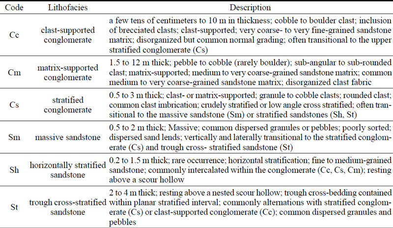
입도변화, 퇴적구조, 구성물질, 역암과 사암의 상대적인 구성비 등을 고려한 퇴적상 조합에 근거하여, 분지충전물을 하부로부터 A, B, C의 세 단위 층으로 분류하였다(그림 2). 각 층의 특징과 퇴적상 조합을 나타내기 위해 표식지에서 주상도를 작성하였다(그림 2, 4; Section 1~4). 주상도의 퇴적상 기호와 기술은 Miall (1992)와 Kee et al. (2006)을 참고하였다(표 1).

Description of sedimentary facies in the representative columnar sections of the Pyeonghae Basin fills.
대부분 분지의 서편 경계단층을 따라 분포하는 A층은 중력류 기원의 이동도가 낮은 조립질 퇴적물이 우세하다. 백악기 퇴적암과 인접한 분지 서편 경계 지역(그림 2의 Section 1)에는 주변 자색 퇴적암 기원의 역들로 구성된 괴상의 역지지성 역암(Cc)이 관찰된다(그림 3a). 직경 1 m 이상의 암괴를 포함한 각형의 거력(boulder)들 사이의 기질부는 사질과 이질 퇴적물로 이루어져 있다. 상부로 가면서 왕자갈 내지 잔자갈 크기로 입도가 감소하는 상향세립화가 관찰되며, 평균 약 20 cm 두께를 가지는 조립질의 렌즈상 사암층이 협재된다(그림 4a). 보다 북쪽의 경계단층과 인접한 Section 2에는 주변 변성암에서 기원한 각형 내지 아각형의 역들로 구성된 역암층이 잘 관찰되며, 이곳에도 상향세립화가 인지된다(그림 4b). A층은 약 25 m의 층후를 보이며, 하부에는 역지지성 각력층이 발달하고 상부에는 각형 내지 아각형의 역으로 구성된 괴상의 기질지지성 역암(Cm)이 관찰된다.

Outcrop photographs showing the major features of the Pyeonghae Basin fills. Unit A (a and b) is characterized by the massive, angular to sub-angular, boulder and clast-supported conglomerates observed along (a) the western and (b) eastern border faults. Unit B (c and d) is mainly composed of massive to crudely imbricated, sub-angular to sub-rounded, cobble to boulder size clast-dominated conglomerate beds intercalated with lens-shaped (gravelly) sandstones. Unit C (e and f) consists of crudely to moderately imbricated, sub-rounded to well-rounded, moderately sorted, pebble- to cobble-size conglomerate beds intercalated with relatively well-extended to lens-shaped (gravelly) sandstone units.

Representative outcrop columnar sections of the Unit A, B, and C in the Pyeonghae Basin. (a, b) Unit A and Unit B in Section 1 and 2 adjacent to the western border fault, characterized by brecciated boulders and clast- and matrix-supported conglomerates. (c) Unit A in Section 3 distributed adjacent to the eastern border faults, showing a repeated fining upward sequence. (d) Unit C in Section 4 showing imbricated clasts and channelized sandstone. See Table 1 for the detailed characteristics of the basin fill units.
A층은 분지의 서편뿐만 아니라 동편 경계단층을 따라서도 국지적으로 관찰된다(그림 2). Section 3에서 하부에는 직경 1 m 내외의 암괴가 나타나며 상부로 갈수록 거력에서 잔자갈 크기로 상향세립화되는 역지지성 역암이 반복되며(그림 3b), 보다 상위로 가면서 기질지지성 역암과 인편상 역층(Cs)이 관찰된다(그림 4c). 이상의 특징들은 A층이 분지 양쪽 경계의 정단층을 따라 형성된 단층애로부터 반복되는 중력류에 의해 사태성으로 퇴적된 역질이 우세한 분지 기저층임을 알려준다.
B층은 남북 방향으로 길쭉한 분포를 보이며(그림 2), 동쪽으로 가면서 점차 원마도와 분급이 양호해지는 경향이다. B층은 주로 아각형 내지 아원형의 잔자갈 내지 왕자갈로 이루어진 역지지성 내지 기질지지성 역암으로 구성되며, 중·조립질 역질 사암 내지 렌즈상 사암이 협재된다(그림 3c). 분지 서편 경계를 따라 관찰된 B층은 A층을 정합으로 피복하며, 반복되는 역암층 사이에 약 1 m 두께의 수평층리를 보이는 렌즈상의 조립질 사암(Sh)과 괴상 사암(Sm)이 협재한다(Section 1, 그림 4a). 또한, 상부로 갈수록 역층 내의 기질 함량이 증가하고 기질지지성 역암이 우세해지며 역의 배열성이 인지되는 역층(Cs)도 관찰된다. 이뿐만 아니라, 상부로 가면서 역의 크기가 점차 감소하고 기질지지성 역암 내에 측방 연속성이 양호한 렌즈상 사암이 발달한다(Section 2, 그림 3d, 4b). 이러한 특징들은 중력류가 우세한 A층과 달리 B층은 분지가 점차 깊어짐에 따라 발생한 유수의 영향을 많이 받았으며, 분지의 퇴적환경이 서편 경계에서 동쪽으로 가면서 사태성 환경에서 점차 하천성 환경으로 전이됨을 지시한다.
평해분지 충전물 중 가장 상위층인 C층은 분지 북동부에 국한되어 분포한다(그림 2). 대규모 공사현장 사면(Section 4)을 따라 약 25 m 두께로 노출된 C층(그림 3e)은 B층에 비해 입도가 감소되고 양호한 분급과 원마도를 보이며, 층리가 발달하는 역층과 왕모래에서 왕자갈 크기의 역질 사암층의 호층이 발달한다(그림 3f). C층에서는 특히 사질층의 두께가 증가하고 구성 비율이 높아지며 측방연속성이 좋다(그림 4d). 또한 잔자갈 내지 조립질 모래로 구성된 하도형의 역질 사암(St)과 괴상의 렌즈상 사암(Sm)이 흔히 관찰된다. 이와 같은 다수의 하도형 퇴적구조, 역층 내 인편상 배열 등은 C층의 분포지로 갈수록 분지가 깊어지고 하천과 같은 유수의 작용이 보다 활발해짐을 지시한다.
4. 지질구조
4.1 지층자세
평해분지 충전물은 고결도가 낮고 대부분 초기 경사(initial dip)를 배제할 수 없는 역암으로 구성되어 정확한 고수평면을 지시하는 층리면의 자세를 측정하기에는 현실적인 어려움이 있다. 이러한 불확실성을 최소화하기 위해 가능한 세립질 퇴적층을 대상으로 분지 전반에 걸쳐 고르게 많은 지층의 자세를 측정하고자 하였다. 총 157개의 자세가 수집되었으며, 지층 자취(bedding trace)를 도시하고 극점투영과 장미도표를 통해 지층자세의 시·공간적인 변화를 분석하였다(그림 5, 6, 7).

Structural map showing the geometry and kinematics of the major faults, stratal attitudes of the basin fill and basement rocks, and geometry of folds in the Pyeonghae Basin. The π-axis of a fold (rollover anticline) adjacent to the western border fault is almost parallel to the fault. The yellowish circle indicates the location of the Quaternary fault outcrop reported previously as the ‘Pyeonghae Fault’.

Contoured π- (lower hemisphere, equal-area stereo projection) and rose-diagrams showing the stratal attitudes of the basin fill. Red lines indicate the arithmetic means of the dip directions and angles.

Rose-diagrams showing the dip angles of strata for each unit of the basin fills. Red lines indicate the arithmetic means of the dip angles.
평해분지 전체 충전물의 자세는 전반적으로 분지 서편 경계단층과 유사한 주향을 가지며 다수가 남동 내지 동남동쪽으로 경사진다(그림 6). 평균 경사방향과 경사각은 각각 S70°E와 12.9°이다. 그러나 연구지역 중앙부에 북동-남서 방향으로 발달하는 계곡부를 중심으로 분지의 북부와 남부의 지층은 경사방향에서 상당한 차이를 보인다(그림 5). 북부는 전반적인 지층자세와 유사하게 평균 S48°E의 경사방향으로 대부분 남동쪽으로 경사지는 반면, 남부는 경사방향이 평균 N18°E로 북서와 북동쪽으로 분산되어 경사된 양상이다(그림 6). 한편, 세 층의 각 평균 층리면의 경사는 아주 미소하나 상부로 갈수록 점진적으로 감소하는 경향을 보인다(그림 7).
4.2 분지 서편 경계단층
평해분지의 서편 경계는 포항분지와 유사하게(Song, 2015) 북동 방향의 정단층과 이들을 계단식(stepping)으로 잇는 북서 방향의 주향이동단층(이음단층, transfer fault)에 의해 구획된다(그림 5). 야외에서 측정된 8개 정단층과 3개의 이음단층의 자세를 살펴보면(그림 8), 정단층은 N15~54°E의 주향을 가지며 29~54° 남동 방향으로 경사진다. 반면, 이음단층은 N54~58°W의 주향으로 남서 혹은 북동으로 경사진다(그림 9c, 9d). 북북동 방향의 정단층은 분지 경계부에서 점완·서가형(listric-domino)의 기하를 보이기도 하는데, 하부로 가면서 단층면들의 경사가 완만해지고 지괴들이 모두 서쪽으로 경동되는 모습이다(그림 9a, 9b). 이와 함께 경계단층 인접부에서 단층을 향해 경사지던 분지충전물이 단층에서 멀어지면 반대로 경사져 하나의 습곡을 형성하고 있다(그림 5). 이 습곡축의 자세는 02°/N35°E로 인접한 경계단층(N38°E/54°SE)의 주향과 거의 평행하다.

Stereographic plot of the western basin-bounding faults, including NNE- to NE-trending normal faults and WNW- to NW-trending transfer faults.

Outcrop photograph (a) and (b) its sketch showing the features of NE-striking listric- and domino-type normal faults observed in the western margin of the Pyeonghae Basin. Outcrop photographs showing the NW-striking transfer faults dipping toward (c) NE and (d) SW.
4.3 분지 내부 신장구조
분지 내부에 발달하는 신장구조로 앞서 설명한 구름배사와 함께 서편 경계단층 인접부에서 지구와 지루(graben and horst) 구조가 관찰되며, 분지 동편에는 충전물을 절단하는 소규모 정단층들이 관찰된다. 지구와 지루 구조는 평해읍 평해리에서 남북과 북동 방향의 공액상 정단층들(conjugate normal faults)에 의해 기반암의 지루와 그 양편에 분지충전물로 충전된 지구를 형성한다(그림 10a). 지구와 지루는 열개분지(rift-basin)를 비롯한 확장성 퇴적분지에서 발달하는 대표적인 신장구조이다. 한편, 평해읍 오곡리에는 분지충전물을 절단하는 소규모 정단층들에 의해 만들어진 지루와 지구가 관찰된다(그림 10b). 이 정단층군은 북북동 내지 북북서의 체계적인 배열을 갖는 공액상 단층의 기하를 이루며, 약 20 cm의 정이동성 겉보기 수직변위(separation)와 정단층 운동을 지시하는 끌림습곡(drag fold)이 관찰된다. 노두에서 관찰된 총 9매의 공액상 단층은 N06°~31°E/53°~83°SE의 자세를 보이는 3매와 N05°~19W°/41°~85°SW의 자세를 가진 6매의 단층으로 이루어진다. 특히 이들 정단층의 상반에 위치한 지층이 이에 대비되는 하반의 지층에 비해 두껍고 상부로 갈수록 변위가 감소하는 퇴적동시성 성장단층(syndepositional growth fault)의 특징을 보여준다.

Outcrop photographs showing the major features of the intrabasinal faults in the Pyeonghae Basin. (a) A horst-graben structure produced by the NS- and NE-striking conjugate normal faulting adjacent to the western border fault. (b) Syn-depositional conjugate normal faults making a typical graben in the basin fill.
4.4 고응력장 복원
평해분지의 경계와 분지충전물 내 단층들은 대부분 미고결 퇴적물과 접하고 있어 단층면에 뚜렷한 조선(slickenline)이 인지되지 않는다. 따라서 이번 연구에서는 분지의 경계단층과 내부에 발달하는 정단층들의 공액상 단층 기하를 이용하여 고응력장을 분석하였다. 그 결과, 분지 동편 경계에 인접한 기반암 내의 남북 방향 단층과 서편을 경계하는 북동 방향 정단층들의 기하를 이용해 서북서-동남동 방향의 최소수평응력(σHmin)이 도출되었다(그림 11a). 또한 분지충전물을 절단하는 공액상 정단층들을 이용한 경우에도 유사하게 동-서 내지 서북서-동남동 방향의 최소수평응력이 구해졌다(그림 11b).

Paleostress-field reconstructions from (a) the basin bounding faults and (b) the intrabasinal syn-depositional faults, using their conjugate fault geometries. Divergent arrow heads represent the direction of horizontal stress (σHmin). The principal stress axes σ1 (filled circle), σ2 (filled triangle), σ3 (filled squares) are also projected. Thick great circles indicate the mean attitude of each conjugate fault pairs.
4.5. 분지 동편 경계단층 (재활구조)
평해분지의 동편은 거의 직선으로 뻗어있는 남북 내지 북북동 방향의 역이동성 우수향 주향이동단층에 의해 현재 경계되어 있다(그림 5). 이 단층은 Choi et al. (2012)의 활성단층 조사에서 평해단층(지점)으로 명명된 바 있으나, 실제로는 양산단층의 북쪽 연장으로 제4기에 역단층으로 재활된 것이다. 이번 조사를 통해 새로이 발견된 평해분지 동편 경계단층은 북북서 주향과 65° 이상의 고경사로 놓인 단층면을 따라 고원생대 변성암류를 분지충전물뿐만 아니라 현생 하천 퇴적물의 상위로 충상시킨 사교이동단층이다(그림 12a, 12b). 이곳 단층대는 6 m 내외 폭의 단층핵(fault core)과 최소 1 m 이상 폭의 단층손상대(fault damage zone)로 구성되며, 단층핵 내부에는 N14°W/65°NE의 주 단층면과 다수의 남북 내지 북북동 방향의 전단면들이 관찰된다. 주 단층면에서 관찰된 조선과 비지대 내의 입자의 변형과 회전 양상을 종합하면, 이 단층의 마지막 운동은 역이동성을 포함한 우수향 주향이동이다(그림 12c, 12d). 이처럼 평해분지의 동편은 양산단층의 북부 연장에 해당되는 남북 내지 북북동 방향의 단층대가 제4기에 역이동성 우수향 주향이동단층으로 재활된 형태로 경계를 이루고 있다.

Outcrop photographs show the major features of the eastern border fault of the Pyeonghae Basin. (a, b) Basement-derived fault core in the hanging wall and the basin fill in the footwall are bordered by a NNW-striking dextral reverse fault (the northern extension of the Yangsan Fault). (c) Slickenline on the fault surface indicates the dextral reverse oblique-slip movement. Black arrow and dashed line indicate the movement direction of missing block and a horizontal line, respectively. (d) Tectonic fish (clast) indicate the dextral shear sense of the eastern border fault.
5. 토 의
5.1 분지의 기하와 확장형식
평해분지의 서편 경계는 점완·서가형 정단층의 기하를 보이며(그림 9a-b), 이와 인접한 곳에 단층 각력에서 유래된 것으로 판단되는 분급과 원마도가 매우 불량한 역암이 퇴적되어 있다. 경계단층 인접부에서 단층을 향해 경사지던 충전물은 단층과 멀어지면서 반대로 경사지며 인접한 경계단층의 주향과 평행한 축을 갖는 배사형 습곡을 형성한다(그림 5). 이러한 점은 이 습곡이 북동 방향 경계단층의 점완형 운동에 의해 상반에 만들어지는 구름배사(rollover anticline)일 가능성을 시사한다. 또한 분지 내부로 갈수록 이동도가 높은 아원형 내지 원형의 역층과 성층화된 사질층이 발달하고 있어, 서편 경계단층은 분지확장에 직접 관여한 퇴적동시성 단층으로 해석된다. 반면, 분지 동편의 경우 양산단층 북쪽 연장에 해당하며 현재 역이동성 우수향 주향이동단층으로 재활된 특성을 보인다(그림 12). 평해분지 충전물은 상부로 갈수록 입도가 감소하고 원마도와 분급이 양호해지며 역층 내 기질 비율이 증가하고 사질층의 층리와 측방 연속성이 양호해지는 일련의 변화를 보인다. 이러한 특징은 최초 분지 경계에서 발생한 정단층 운동으로 침강되면서 사태성의 역질 퇴적물이 유입되었으며, 이후 점차 분지가 확장되고 깊어져 하도가 형성됨에 따라 활발한 유수작용에 의해 원마도와 분급이 양호하고 층리와 측방 연속성이 좋은 사질층이 우세하게 퇴적되는 일련의 분지발달과정을 겪었음을 지시한다. 그러나 평해분지에는 전형적인 호수 또는 호수연변 퇴적상이 관찰되지 않으므로 분지의 성숙도(maturity)는 낮으며, 가장 조립의 충전물이 분지 서편 경계를 따라 주로 분포하고 퇴적물의 입도가 동쪽으로 가면서 감소하고 있어 평해분지는 동편으로 갈수록 분지 심도가 깊어지는 비대칭형 지구대(asymmetrical graben)를 이룰 것으로 해석된다(그림 2b).
평해분지 충전물의 층리는 전반적으로 남동 내지 동남동으로 경사지며, 분지 남부는 완만한 습곡의 기하를 이룬다. 충전물의 상부로 갈수록 점진적으로 경사각이 감소한다(그림 7). 점완 또는 서가형 단층운동이 활발하였던 분지충전물 층리의 경사 방향은 분지 기저의 경동과 확장 방향 그리고 분지확장 과정에서 가장 변위가 큰 정단층의 위치를 지시한다(Wise, 1992; Lucchitta and Suneson, 1993; Scott et al., 1994; Son et al., 2000a, 2005; Koçyiğit, 2005; Changbo et al., 2007; Serck and Braathen, 2019). 평해분지의 동편 경계단층은 서편에 비해 연장성과 선형성이 탁월하다(그림 5). 일반적으로 단층의 연장과 변위량이 서로 정의 상관관계를 보인다는 기존 연구결과(Marrett and Allemendinger, 1991; Cartwright et al., 1995; Dawers and Anders, 1995; Cartwright and Mansfield, 1998; Cowie et al., 2000)를 참고하면, 평해분지의 동편 경계단층이 비록 고각도의 역이동성 우수향 주향이동단층으로 현재 재활되어 있지만 분지 확장 동안에는 서편 경계단층보다 수직변위가 더 커서 분지 침강을 주도하였을 가능성이 높다. 그러나 양산단층은 평해분지 형성 전부터 존재하던 단층이므로 그 연장성 만으로는 분지 동쪽 경계단층의 변위량을 직접적으로 지시하기 어렵다는 점도 더불어 감안해야 할 것이다.
한반도 동남부에서 보고된 신생대 분지들은 대부분 동해확장과 관련되며, 짝을 이룬 북북서 방향의 주변위대와 이를 잇는 북동 내지 북북동 방향의 정단층에 의해 확장된 당겨열림분지로 해석되고 있다(Son et al., 2013, 2015). 최근에는 포항분지의 남단의 보문소분지에 대한 구조해석을 통해 이 분지가 연일구조선의 북단에 위치한 북북동 방향의 정단층에 의해 확장된 횡인장단층말단분지(transtensional fault-termination basin; Umhoefer et al., 2007; Song et al., 2022)로 해석되었다. 그러나 평해분지는 북북동 방향으로 길쭉한 대상의 분포를 보이며 주향이동성 주변위대가 존재하지 않는다. 또한 분지 내부에서 퇴적동시성 남북 내지 북북동 방향의 지구와 지루 구조(그림 10)가 관찰되고 서북서-동남동 방향의 최소수평응력을 지시하는 고응력장이 복원되었다(그림 11). 이는 평해분지가 양편 경계를 이루는 정단층에 거의 수직한 서북서-동남동 방향의 인장력에 의해 확장된 하나의 전형적인 열개분지(rift basin)임을 지시한다. 한편, 평해분지의 동편 경계에서 관찰된 국부적인 압축 구조는 동아시아 일원 신기 지각변형과 관련되어 양산단층을 따라 도처에서 관찰되는 제4기 동안의 역이동성 우수향 주향이동단층 운동의 결과로 판단된다.
5.2 분지의 확장시기와 발달사
낙동강 하구에서부터 북북동쪽으로 연장되는 양산단층은 경상북도 영덕군 영해면과 울진군 평해읍 일대까지 선형구조와 단층핵 노두들로 이어져 평해분지의 동편 경계를 이룬다(그림 1; Chang et al., 1990; Choi et al., 2012; Kee et al., 2019; Ko et al., 2022). 따라서 양산단층은 평해분지의 확장과 이후 변형 과정에서 주도적 역할을 하였을 것으로 판단된다. 양산단층은 백악기 이래로 다양한 운동감각으로 다중변형을 겪었으며, 특히 우수향 주향이동은 양산단층의 운동사에서 가장 뚜렷한 기록을 남겼다(Chang et al., 1990; Kim, 1992; Chang and Chang, 1998; Chang, 2002; Hwang et al., 2004, 2007a, 2007b, 2008, 2012; Cho et al., 2007, 2016; Choi et al., 2009; Kang and Ryoo, 2009; Ha et al., 2016; Kim et al., 2016; Cheon et al., 2017, 2019). 포항시 기계면과 경주시 배동 일대에서 특이한 암상으로 산출되는 약 50 Ma의 A형 알칼리장석화강암의 분포를 통해 양산단층의 약 21.3 km 우수향 수평변위가 보고되었다(Hwang et al., 2004, 2007a). 또한, 양산단층계에 속하는 일광단층과 법기단층에 의해 51~44 Ma의 40Ar/39Ar 연령을 보이는 남북 내지 북북동 방향의 염기성 암맥군(dike swarm)이 우수향으로 절단됨이 보고되었다(Son et al., 2003; Ha et al., 2016). 한편, 한반도 동남부의 마이오세 분지들은 일관되게 북북서 방향의 우수향 전단력에 의해 발생한 서북서-동남동 혹은 북서-남동 방향의 인장 응력에 의해 확장된 것으로 알려져 있어(Son and Kim, 1994; Son, 1998; Son et al., 2000a, 2000b, 2005, 2007, 2013, 2015; Kim et al., 2011, 2015; Cheon et al., 2012; Jung et al., 2012; Seong et al., 2013; Kim, 2018; Song et al., 2022), 당시에 양산단층을 따라 변형이 발생하였다면 주향이동이 아니라 정이동으로 운동하였을 것이다. 따라서 양산단층의 우수향 주향이동운동은 남북 내지 북북동 방향의 염기성 암맥군의 관입(약 44 Ma)한 이후이며 마이오세 분지 확장기(약 24 Ma) 이전에 발생한 것으로 해석된다(Cheon et al., 2019).
한반도 동남부 마이오세 분지들의 확장과정에서 양산단층의 역할은 매우 미미하였던 것으로 알려져 있다(Son et al., 2013, 2015; Song et al., 2022). 실제 포항분지와 그 남쪽의 마이오세 분지들은 양산단층과 접하고 있지 않으며, 연일구조선과 지그재그 형태로 연장되는 포항분지 서편 경계단층에 의해 규제된다(그림 1a). 그러나 포항분지 서편 경계단층이 북쪽 말단에 이르러서는 양산단층과 연결되며 그 북쪽의 영해분지의 동편 경계가 양산단층으로 이루어져 있음은 주목할 만하다. 이는 마이오세 지각변형 과정에서 남부 양산단층의 운동은 미미하였다 하더라도 포항분지 보다 북쪽의 북부 양산단층을 따라서는 정이동성 단층운동이 발생하였을 가능성을 보여준다. 한편, 약 5 Ma 이래로 동아시아 일원은 인도와 유라시아 대륙의 충돌에 의해 전파된 응력(아무르판의 동진)과 태평양판의 이동방향과 섭입각도의 변화에 의해 동북동-서남서 방향의 압축 응력장 하에 놓여있는 것으로 알려져 있다(Kim et al., 2016). 이로 인해 양산단층의 여러 구간이 우수향 횡압축성 운동감각으로 재활되었으며, 이는 오늘날의 한반도 일원에서 발생하는 지진 발생의 원인이 되고 있다(Kyung et al., 1999; Kyung and Chang, 2001; Kim and Jin, 2006; Kang and Ryoo, 2009; Yang and Lee, 2014; Kim, C.-M. et al., 2016; Lee et al., 2017; Kim, T. et al., 2020; Song et al., 2020; Kim, N. et al., 2021, 2023).
평해분지는 동아시아 일원의 응력장 변화에 따른 양산단층의 운동감각의 변화 즉, 마이오세 이전의 우수향 주향이동, 마이오세 동안의 정이동 그리고 약 5 Ma 이후의 역이동성 우수향 주향이동 단층운동과 밀접한 관련을 가지고 진화하였으며, 분지의 확장 이전부터 확장 동안 그리고 이후의 변형 단계로 이어지는 순차적인 발달과정을 겪은 것으로 판단된다(그림 13). 먼저, 분지확장 이전(pre-rift) 단계인 24 Ma 이전의 신생대에는 북동-남서 압축 응력 하에서 양산단층이 우수향 주향이동단층으로 운동함에 따라 단층 동편의 기반암 지괴가 상대적으로 남쪽으로 약 35 km 수평이동하고 고원생대 변성암류와 백악기 퇴적암류를 경계하는 일월산스러스트도 우향 절단되었다(Chang et al., 1990). 또한 양산단층이 우수향 주향이동을 하는 동안 단층 인접부에는 북동 방향의 R-전단(shear) 단층들이 만들어졌을 것이다. 이후 마이오세(syn-rift stage)에 이르러서 평해읍 일대에 서북서-동남동 방향의 인장력이 작용하면서 양산단층은 정단층으로 운동한 것으로 판단된다. 양산단층과 함께 단층 서편의 기존 R-전단들이 정단층으로 함께 재활되면서 이들 단층 사이의 지각이 침강하게 되고, 이로 인해 평해분지는 북북동 방향의 확장축을 갖는 정향(synthetic) 및 반향(antithetic) 단층들의 정이동성 운동에 의한 비대칭형 지구대로 발전한 것으로 해석된다. 이후 약 5 Ma에 이르러서는 양산단층에 동북동-서남서 방향의 압축응력이 작동되었고(post-rift stage), 양산단층은 역이동성 우수향 주향이동단층으로 재활하게 되어 현재와 같이 분지의 동편을 절단하게 되었다.

Schematic block diagrams showing the evolution of the Pyeonghae Basin, which consists of the four stages of pre-rift, initial syn-rift, climax syn-rift, and post-rift (inversion).
주로 미고결 역질 퇴적물로 채워진 낮은 성숙도의 평해분지에는 화산물질과 화석이 산출되지 않아 정확한 퇴적시기를 알 수 없으나, 분지의 경계와 충전물의 특성이 남쪽의 중기 마이오세 분지들과 상당한 유사성을 보인다. 약 17 Ma에 연일구조선의 운동이 시작되면서 퇴적중심이 중기 마이오세에 북쪽의 포항분지로 이동하였다(Son et al., 2013, 2015). 포항분지는 서북서-동남동 방향으로 확장되었으며(Song, 2015), 비록 서편 경계단층이 양산단층 보다 약 2~5 km 동편에 위치하지만 북쪽 말단에서 양산단층과 연결되고 있어(그림 1a) 포항분지 이북의 양산단층은 중기 마이오세에 정단층으로 운동했을 가능성이 높다. 평해분지와 가장 근접한 영해분지가 중기 마이오세 퇴적물로 충전되고 양산단층에 의해 동편이 경계되고 있음(Kim, 1970; Park et al., 2010; Ahmad, 2020)은 이와 같은 해석을 지지한다. 또한 평해분지 충전물이 남쪽의 중기 마이오세 퇴적물과 같이 화산성 물질을 포함하지 않는 점도 평해분지가 중기 마이오세에 양산단층의 정단층 운동과 함께 확장되었음을 지지해 준다.
6. 결 론
이번 연구는 울진군 평해읍 일원에 위치하는 시대 미상의 평해분지를 대상으로 정밀한 야외지질조사를 통해 충전물을 분대하고 각 층의 특징을 파악하였으며, 분지 경계와 내부에 발달하는 주요 지질구조의 기하 및 운동학적 자료들을 분석하고 고응력장을 복원하였다. 이를 통해 평해분지의 기하와 확장형식을 밝히고 발달사를 토의하였다. 주요 연구결과는 다음과 같다.
1) 평해분지는 길이 4 km와 폭 1 km 내외의 북북동-남남서 방향으로 길쭉한 인장틈 형태의 구조분지이다. 분지의 동편은 북북동 방향의 역이동성 우수향 주향이동단층으로 재활된 북부 양산단층에 의해 기반암과 경계되며, 분지 서편은 북북동 내지 북동 방향의 정단층과 이를 연결하는 서북서 방향의 이음단층에 의해 경계된다. 분지충전물은 역암 내지 역질 사암으로 구성되며, 상부와 동쪽으로 갈수록 입도가 감소하고 분급과 원마도가 양호해지는 시·공간적인 퇴적상 변화를 보인다.
2) 평해분지 충전물의 전반적인 지층 자세는 남동 방향으로 경사지나, 분지 남부는 완만한 습곡의 기하를 보인다. 충전물의 상부로 갈수록 경사가 점진적으로 감소하는 경향을 보인다. 이러한 특징은 퇴적상의 공간적 변화와 함께 평해분지가 동쪽으로 향하는 퇴적동시성 지괴경동을 겪은 이후 분지 남부가 국부적으로 다시 변형되었음을 의미한다. 따라서 평해분지는 서편 경계단층에 비해 동편 경계인 양산단층에서 보다 큰 수직변위가 발생하여 동쪽으로 분지 기저가 경동된 비대칭형 지구대의 기하를 가지는 것으로 해석된다.
3) 분지 경계와 내부에는 북북동 내지 북동 방향의 점완·서가형 정단층, 남북 내지 북북동 방향의 지구-지루 구조와 공액상 성장단층과 같은 인장구조가 관찰되며, 이들 공액상 정단층의 기하를 이용해 복원한 고응력장은 서북서-동남동 방향의 지각 신장을 지시하고 있어 평해분지는 북북동 방향의 확장축을 가진 열개분지로 판단된다.
4) 평해분지 발달사는 동아시아 일원의 응력장 변화에 따른 양산단층의 운동감각 변화 즉, 마이오세 이전의 우수향 주향이동, 중기 마이오세의 정이동 그리고 약 5 Ma 이후의 역이동성 단층운동으로 이어지는 순차적인 진화과정으로 설명될 수 있다. 즉, 24 Ma 이전의 신생대 동안 북동-남서 압축 응력 하에서 양산단층이 우수향 주향이동단층 운동을 해 동편 기반암 지괴가 상대적으로 남쪽으로 약 35 km 수평이동하였으며, 중기 마이오세에는 서북서-동남동 방향의 인장력이 작용하면서 양산단층의 정단층 운동과 함께 평해분지가 확장되었다. 약 5 Ma 이후에는 동북동-서남서 방향의 압축응력에 의해 양산단층이 역이동성 우수향 주향이동단층으로 재활하면서 평해분지 동편 경계에서 기반암이 충전물 상위로 충상되었다.
Acknowledgments
이 연구는 행정안전부 지진 위험분석 및 관리기술 개발사업(2022-MOIS62-001)과 ‘지진방재분야 전문인력 양성 사업’의 지원에 의해 수행되었다. 심사과정에서 매우 세심하고 건설적인 조언을 주신 편집위원, 익명의 심사위원 그리고 경북대학교 박승익 교수님께 깊이 감사드린다.
References
-
Abdullayev, N.A., Kadirov, F. and Guliyev, I.S., 2017, Subsidence history and basin-fill evolution in the South Caspian Basin from geophysical mapping, flexural backstripping, forward lithospheric modelling and gravity modelling. Geological Society, London, Special Publications, 427, 175-196.
[https://doi.org/10.1144/SP427.5]

- Ahmad, Z.A.A.A., 2020, Architecture and tectonic development of the Yeonghae Basin, eastern margin of the Korean Peninsula. M.S. thesis, Pukyong National University, Busan, 101 p (in Korean with English abstract).
- Allen, P.A. and Allen, J.R., 2005, Basin analysis: Principles and Applications (2nd edition). Blackwell Publishing, USA, UK, Australia, 549 p.
-
Bally, A.W., Roberts, D.G., Sawyer, D. and Sinkewich, A., 2012, Tectonic and Basin maps of the world. In: Roberts, D.G. and Bally, A.W., Regional Geology and Tectonics: Phanerozoic Passive Margins, Cratonic Basins and Global Tectonic Maps, Elsevier, 970-1025.
[https://doi.org/10.1016/B978-0-444-56357-6.00024-X]
- Byun, H. and Yun, H., 1996/1997, Late Cenozoic dinocysts from the exploration wells of the Pohang basin and the continental shelf of Korea. In: Nishimura, S. and Tsuchi, R. (eds.), Proceedings of Sixth International Congress on Pacific Neogene Stratigraphy and IGCP-355, Gyeongju (1997) and San Jose (1996), 15-30.
- Byun, H., 1995, Cenozoic dinoflagellate cysts from the Pohang basin and the southern margin of the Ulleung basin. Ph.D. thesis, Chungnam National University, Daejeon, 283 p (in Korean with English abstract).
-
Cartwright, J.A. and Mansfield, C.S., 1998, Lateral displacement variation and lateral tip geometry of normal faults in Canyonlands National Park, Utah. Journal of Structural Geology, 20, 3-19.
[https://doi.org/10.1016/S0191-8141(97)00079-5]
-
Cartwright, J.A., Trudgill, B.D. and Mansfield, C.S., 1995, Fault growth by segment linkage: an explanation for scatterin maximum displacement and trace length data from the Canyonlands Graben of S.E. Utah. Journal of Structural Geology, 17, 1319-1326.
[https://doi.org/10.1016/0191-8141(95)00033-A]
- Chae, B.-G. and Chang, T.-W., 1994, Movement history of Yangsan Fault and its related fractures at Chongha-Yongdok area, Korea. Journal of the Geological Society of Korea, 30, 378-394 (in Korean with English abstract).
- Chang, C.-J., 2002, Structural characteristics and evolution of the Yangsan fault, SE Korea. Ph.D. thesis, Kyungpook National University, Daegu, 259 p (in Korean with English abstract).
- Chang, C.-J. and Chang, T.W., 1998, Movement history of the Yangsan Fault based on Paleostress analysis. The Journal of Engineering Geology, 8, 35-49 (in Korean with English abstract).
- Chang, K.H., Woo, B.G., Lee, J.H., Park, S.O. and Yao, A., 1990, Cretaceous and early Cenozoic stratigraphy and history of eastern Kyongsang Basin, S. Korea. Journal of the Geological Society of Korea, 26, 471-487.
-
Changbo, G., Hengmao, T., Yudan, H. and Chunguang, W., 2007, Sandbox modeling of the fault-increment pattern in extensional basins. Petroleum Science, 4, 29-34.
[https://doi.org/10.1007/BF03187438]
-
Cheon, Y., Cho, H., Ha, S., Kang, H., Kim, J.-S. and Son, M., 2019, Tectonically controlled multiple deformations along the Yangsan Fault Zone, SE Korea, since Late Cretaceous. Journal of Asian Earth Sciences, 170, 188-207 (in Korean with English abstract).
[https://doi.org/10.1016/j.jseaes.2018.11.003]
-
Cheon, Y., Ha, S., Lee, S., Cho, H. and Son, M., 2017, Deformation features and history of the Yangsan Fault Zone in the Eonyang-Gyeongju area, SE Korea. Journal of the Geological Society of Korea, 53, 95-114 (in Korean with English abstract).
[https://doi.org/10.14770/jgsk.2017.53.1.95]
-
Cheon, Y., Ha, S., Lee, S. and Son, M., 2020, Tectonic evolution of the Cretaceous Gyeongsang Back-arc Basin, SE Korea: Transition from sinistral transtension to strike-slip kinematics. Gondwana Research, 83, 16-35.
[https://doi.org/10.1016/j.gr.2020.01.012]
-
Cheon, Y., Son, M., Song, C.W., Kim, J.-S. and Sohn, Y.K., 2012, Geometry and kinematics of the Ocheon Fault System along the boundary between the Miocene Pohang and Janggi basins, SE Korea, and its tectonic implications. Geosciences Journal, 16, 253-273.
[https://doi.org/10.1007/s12303-012-0029-0]
-
Cho, H., Son, M., Cheon, Y., Sohn, Y.K., Kim, J.-S. and Kang, H.-C., 2016, Evolution of the Late Cretaceous Dadepo Basin, SE Korea, in response to oblique subduction of the proto-Pacific (Izanagi/Kula) or Pacific plate. Gondwana Research, 39, 145-164.
[https://doi.org/10.1016/j.gr.2016.07.004]
- Cho, H., Son, M. and Kim, I.-S., 2007, Anisotropy of magnetic susceptibility (AMS) of the granitic rocks in the Eastern Region of the Yangsan Fault. Economic and Environmental Geology, 40, 171-189 (in Korean with English abstract).
- Choi, H.I., Oh, J.H., Shin, S.C. and Yang, M.Y., 1980, Geology and geochemistry of the Gyeongsang strata in Ulsan area. Korea Institute of Energy and Resources Bulletin, 20, 33 (in Korean with English abstract).
- Choi, J.-H., Yang, S.-J. and Kim, Y.-S., 2009, Fault zone classification and structural characteristics of the southern Yangsan fault in the Sangcheon-ri area, SE Korea. Journal of the Geological Society of Korea, 45, 9-28 (in Korean with English abstract).
- Choi, S.-J., Jeon, J.S., Song, G.Y., Kim, H.C., Kim, Y.H., Choi, B.Y., Chwae, W.C., Han, J.G., Ryoo, C.R., Seon, C.G., Cho, M.S., Kim, K.Y., Kim, Y.B., Lee, H.J., Shin, J.S., Lee, Y.S., Kee, W.S., Lee, H.K., Song, Y.G., Kim, Y.S., Kang, T.S., Hong, D.G. and Kim, S.G., 2012, Active Fault Map and Seismic Hazard Map. Natural emergency Management Agency, Seoul, 939 p (in Korean with English abstract).
-
Chough, S.K., Kwon, S.T., Ree, J.H. and Choi, D.K., 2000, Tectonic and sedimentary evolution of the Korean peninsula: a review and new view. Earth-Science Reviews, 52, 175-235.
[https://doi.org/10.1016/S0012-8252(00)00029-5]
-
Cowie, P.A., Gupta, S. and Dawers, N.H., 2000, Implications of fault array evolution for synrift depocentre development: insights from a numerical fault growth model. Basin Research, 12, 241-261.
[https://doi.org/10.1111/j.1365-2117.2000.00126.x]
-
Dawers, N.H. and Anders, M.H., 1995, Displacement-lengthscaling and fault linkage. Journal of Structural Geology, 17, 607-614.
[https://doi.org/10.1016/0191-8141(94)00091-D]
-
Fabbri, O., Charvet, J. and Fournier, M., 1996, Alternative senses of displacement along the Tsushima fault system during the Neogene based on fracture analyses near the western margin of the Japan Sea. Tectonophysics, 257, 275-295.
[https://doi.org/10.1016/0040-1951(95)00151-4]
-
Gawthorpe, R.L. and Leeder, M.R., 2000, Tectono-sedimentary evolution of active extensional basins. Basin Research, 12, 195-218.
[https://doi.org/10.1111/j.1365-2117.2000.00121.x]
-
Ha, S., Cheon, Y., Kang, H.-C., Kim, J.-S., Lee, S.-K. and Son, M., 2016, Geometry and kinematics of the subsidiary faults of the Ilgwang Fault, SE Korea. Journal of the Geological Society of Korea, 52, 31-50 (in Korean with English abstract).
[https://doi.org/10.14770/jgsk.2016.52.1.31]
-
Ha, S., Son, M. and Seong, Y.B., 2022, Active Fault Trace Identification Using a LiDAR High-Resolution DEM: A Case Study of the Central Yangsan Fault, Korea. Remote Sensing, 14, 4838.
[https://doi.org/10.3390/rs14194838]
- Han, J.K., Kwak, Y.H., Son, J.D. and Son, B.K., 1987, Tectonic evolution and depositional environments of the Tertiary sedimentary basin, southeastern part of Korea. Report KR-86-2-(B)-4, Korea Institute of Energy and Resources, Seoul, 109 p.
-
Hossain, M.S., Khan, M.S.H., Abdullah, R. and Mukherjee, S., 2021, Late Cenozoic transpression at the plate boundary: Kinematics of the eastern segment of the Dauki Fault Zone (Bangladesh) and tectonic evolution of the petroliferous NE Bengal Basin. Marine and Petroleum Geology, 131, 105133.
[https://doi.org/10.1016/j.marpetgeo.2021.105133]
- Hwang, B.-H., Lee, J.-D. and Yang, K., 2004, Petrological study of the granitic rocks around the Yangsan fault: Lateral displacement of the Yangsan fault. Journal of the Geological Society of Korea, 40, 161-178 (in Korean with English abstract).
-
Hwang, B.-H., Lee, J.-D., Yang, K. and McWilliams, M., 2007a, Cenozoic strike-slip displacement along the Yangsan fault, southeast Korean Peninsula. International Geology Review, 49, 768-775.
[https://doi.org/10.2747/0020-6814.49.8.768]
-
Hwang, B.-H., McWilliams, M., Son, M. and Yang, K., 2007b, Tectonic implication of A-type granites across the Yangsan fault, Gigye and Gyeongju areas, southeast Korean Peninsula. International Geology Review, 49, 1094-1102.
[https://doi.org/10.2747/0020-6814.49.12.1094]
-
Hwang, B.-H., Son, M., Kim, J.-S., Yang, K. and Kim, J.-S., 2012, Cenozoic wrench tectonics and oroclinal bending in SE Korea. International Geology Review, 54, 642-653.
[https://doi.org/10.1080/00206814.2011.562389]
-
Hwang, B.-H., Son, M., Yang, K., Yoon, J. and Ernst, W.G., 2008, Tectonic evolution of the Gyeongsang Basin, southeastern Korea from 140 Ma to the present, based on a strike-slip and block-rotation tectonic model. International Geology Review, 50, 343-363.
[https://doi.org/10.2747/0020-6814.50.4.343]
- Hwang, J.H., Kim, D.H., Cho, D.R. and Song, K.Y., 1996, Explanatory Note of The Andong Sheet, 1:250,000. Korea Institute of Geoscience and Mineral Resources, 67 p.
-
Ingersoll, R.V., 2011, Tectonics of sedimentary basins, with revised nomenclature. In: Busby, C. and Azor, A. (eds.), Tectonics of Sedimentary Basins. John Wiley & Sons, Ltd, Chichester, UK, 1-43.
[https://doi.org/10.1002/9781444347166.ch1]
- Jung, S., Kim, M.C., Cho, H., Son, M. and Sohn, Y.K., 2012, Basin fills and geological structures of the Miocene Yangpo subbasin in the Janggi-myeon, Pohang, SE Korea. Journal of the Geological Society of Korea, 48, 49-68 (in Korean with English abstract).
- Kang, H.-C., Cheon, Y., Ha, S.M., Seo, K., Shin, H.C. and Son, M., 2018, Geology and U-Pb Age in the Eastern Part of Yeongdeok-gun, Gyeongsangbuk-do, Korea. Journal of the Petrological Society of Korea, 27, 153-171.
- Kang, J.-H. and Ryoo, C.-R., 2009, The movement history of the southern part of the Yangsan Fault Zone interpreted from the geometric and kinematic characteristics of the Sinheung Fault, Eonyang, Gyeongsang Basin, Korea. Journal of the Petrological Society of Korea, 18, 19-30 (in Korean with English abstract).
- Kee, W.-S., Kim, B.C. and Lee, Y.-N., 2006, Sedimentary Environments and Structural Evolution of the Cretaceous Namyang Basin, Korea. Journal of the Geological Society of Korea, 42, 329-351 (in Korean with English abstract).
- Kee, W.-S., Kim, S.W., Hong, P.S., Lee, B.C., Cho, D.R., Byun, U.H., Ko, K., Kwon, C.W., Kim, H.C., Jang, Y., Song, K.Y., Koh, H.J. and Lee, H.J., 2019, 1:1,000,000 Geological Map of Korea. Korea Institute of Geoscience and Mineral Resources.
- Kim, B.K., 1970, A study on the Neogene Tertiary deposits in Korea. Journal of the Geological Society of Korea, 6, 77-96 (in Korean with English abstract).
-
Kim, C.-M., Ha, S. and Son, M., 2020, Evidence of coseismic slip recorded by Quaternary fault materials and microstructures, Naengsuri, Pohang. Journal of the Geological Society of Korea, 56, 175-192 (in Korean with English abstract).
[https://doi.org/10.14770/jgsk.2020.56.2.175]
-
Kim, C.-M., Han, R., Jeong, G.Y., Jeong, J.O. and Son, M., 2016, Internal structure and materials of the Yangsan fault, Bogyeongsa area, Pohang, South Korea. Geosciences Journal, 20, 759-773.
[https://doi.org/10.1007/s12303-016-0019-8]
- Kim, I.-S., 1992, Origin and tectonic evolution of the East Sea (Sea of Japan) and the Yangsan fault system: a new synthetic interpretation. Journal of the Geological Society of Korea, 28, 84-109 (in Korean with English abstract).
- Kim, I.-S., Son, M., Jung, H.-J., Lee, J.-D., Kim, J.-J. and Paik, I.S., 1998, Geological characteristics of Kyongju-Ulsan area: Palaeomagnetism and magnetic susceptibility of the granite rocks in the Ulsan fault area. Economic and Environmental Geology, 31, 31-43 (in Korean with English abstract).
- Kim, J.-S., Son, M., Kim, J.S. and Kim, I.-S., 2002, Tertiary dyke swarms and their tectonic importance in the southeastern part of the Korean peninsula. Journal of the Petrological Society of Korea, 11, 169-181 (in Korean with English abstract).
- Kim, M.-C., 2018, Characteristics of basin fills and structural evolution of the Early Miocene Janggi Basin, SE Korea. Unpublished, Ph.D. thesis, Pusan National University, Busan, 229 p (in Korean with English abstract).
-
Kim, M.-C., Gihm, Y.S., Son, E.-Y., Son, M., Hwang, I.G., Shinn, Y.J. and Choi, H., 2015, Assessment of the potential for geological storage of CO2 based on structural and sedimentologic characteristics in the Miocene Janggi Basin, SE Korea. Journal of the Geological Society of Korea, 51, 253-271 (in Korean with English abstract).
[https://doi.org/10.14770/jgsk.2015.51.3.253]
- Kim, M.-C., Kim, J.-S., Jung, S., Son, M. and Sohn, Y.K., 2011, Classification and stratigraphy of the Miocene basin fills in the northern area of the Janggi-myeon, Pohang, SE Korea. Journal of the Geological Society of Korea, 47, 585-612 (in Korean with English abstract).
-
Kim, N., Park, S.-I., Cho, C.S., Cheon, Y. and Peace, A.L., 2023, Neotectonic transpressional intraplate deformation in eastern Eurasia: Insights from active fault systems in the southeastern Korean Peninsula. Geoscience Frontiers, 14, 101559.
[https://doi.org/10.1016/j.gsf.2023.101559]
-
Kim, N., Park, S.-I. and Choi, J.-H., 2021, Internal architecture and earthquake rupture behavior of a long-lived intraplate strike-slip fault: A case study from the Southern Yangsan Fault, Korea. Tectonophysics, 816, 229006.
[https://doi.org/10.1016/j.tecto.2021.229006]
- Kim, O.J., Hong, M.Y., Park, H.I., Won, J.K., Park, Y.D. and Kim, K.T., 1963, Geological report of the Pyong Hae sheet (1:50,000). Geological Survey of Korea, 22 p (in Korean with English abstract).
-
Kim, T., Shin, H.-C. and Kim, Y.-S., 2020, Characteristics of the topographical deformation in the central part of the Ulsan fault. Journal of the Geological Society of Korea, 56, 193-209 (in Korean with English abstract).
[https://doi.org/10.14770/jgsk.2020.56.2.193]
- Kim, W.H., 1990, Significance of Early to Middle Miocene planktonic foraminiferal biostratigraphy of the E-core in the Pohang basin, Korea. Journal of the Paleontological Society of Korea, 6, 144-164 (in Korean with English abstract).
- Kim, Y.-S. and Jin, K., 2006, Estimated earthquake magnitude from the Yugye Fault displacement on a trench section in Pohang, SE Korea. Journal of the Geological Society of Korea, 42, 79-94 (in Korean with English abstract).
-
Ko, K., Choi, S.-J., Lee, T.-H., Gihm, T.-H., Kim, C.-M., Kim, K. and Cheon, Y., 2022, A multidisciplinary approach to characterization of the mature northern Yangsan fault in Korea and its active faulting. Marine Geophysical Researches, 43, 21.
[https://doi.org/10.1007/s11001-022-09486-w]
-
Koçyiğit, A., 2005, The Denizli graben-horst system and the eastern limit of western Anatolian continental extension: basin fill, structure, deformational mode, throw amount and episodic evolutionary history, SW Turkey. Geodinamica Acta, 18, 167-208.
[https://doi.org/10.3166/ga.18.167-208]
-
Kusznir, N.J. and Ziegler, P.A., 1992, The mechanics of continental extension and sedimentary basin formation, A simple-shear/pure-shear flexural cantilever model. Tectonophysics, 215, 117-131.
[https://doi.org/10.1016/B978-0-444-89912-5.50049-1]
- Kyung, J.B. and Chang, T.W., 2001, The latest fault movement on the northern Yangsan fault zone around the Yugye-ri area, southeast Korea. Journal of the Geological Society of Korea, 37, 563-577 (in Korean with English abstract).
- Kyung, J.-B., Lee, K., Okada, A., Watanabe, M., Suzuki, Y. and Takemura, K., 1999, Study of fault characteristics by trench survey in the Sangchon-ri area in the southern part of Yangsan fault, southeastern Korea. Journal of Korean Earth Science Society, 20, 101-110 (in Korean with English abstract).
- Lee, H., Park, S.-I. and Choi, T., 2019, A Review on the Stratigraphy, Depositional Age, and Composition of the Chungnam Basin Fills. Economic and Environmental Geology, 52, 357-366 (in Korean with English abstract).
- Lee, H.K., Moon, H.-S., Min, K.D., Kim, I.-S., Yun, H. and Itaya, T., 1992, Paleomagnetism, stratigraphy and geologic structure of the Tertiary Pohang and Changgi basins; K-Ar ages for the volcanic rocks. Journal of the Korean Institute of Mining Geology, 25, 337-349 (in Korean with English abstract).
-
Lee, Y., Cheon, Y., Ha, S., Kang, H.-C., Choi, J.-H. and Son, M., 2017, Geometric and kinematic characteristics of the Quaternary fault at Seooe site, in Goseong-gun, Gyeongsangnam-do. Journal of the Geological Society of Korea, 53, 115-127 (in Korean with English abstract).
[https://doi.org/10.14770/jgsk.2017.53.1.115]
-
Lucchitta, I. and Suneson, N.H., 1993, Dips and extension. Geological Society of America Bulletin, 105, 1346-1356.
[https://doi.org/10.1130/0016-7606(1993)105<1346:DAE>2.3.CO;2]
-
Marrett, R. and Allmendinger, R.W., 1991, Estimates of straindue to brittle faulting: sampling of fault populations. Journal of Structural Geology, 13, 735-738.
[https://doi.org/10.1016/0191-8141(91)90034-G]
-
Meng, Q.-R., Wu, G.-L., Fan, L.-G. and Wei, H.-H., 2019, Tectonic evolution of early Mesozoic sedimentary basins in the North China block. Earth-Science Reviews, 190, 416-438.
[https://doi.org/10.1016/j.earscirev.2018.12.003]
- Miall, A.D., 1992, Alluvial deposits. In: Walker, R.G. and James, N.P. (eds.), Facies Models: response to sea-level change. Geological Association of Canada, 119-142.
- Moon, T.-H., Son, M., Chang, T.-W. and Kim, I.-S., 2000, Paleostress Reconstruction in the Tertiary Basin Areas in Southeastern Korea. Journal of the Korean Earth Sciences Society, 21, 230-249 (in Korean with English abstract).
- Oh, D.Y., 1989, Structural geology and paleostress-field analysis around Ilwol thrust fault, Korea. M.S. thesis, Kyungpook National University, Daegu, 54 p.
- Park, S.H., Choi, J.-H. and Kim, Y.-S., 2010, Structural Approach to the Generation and Development of the Yonghae Basin. 2010 Fall Joint Annual Conference of The Geological Societies in Korea (Abstracts), Gyeongju, October 27-30, 216 p (in Korean).
- Reedman, A.J. and Um, S.H., 1975, The geology of Korea. Geological and Mining Institute of Korea, 139 p.
-
Schandelmeier, H., Bremer, F. and Holl, H.-G., 2004, Kinematic evolution of the Morondava rift basin of SW Madagascar--from wrench tectonics to normal extension. Journal of African Earth Sciences, 38, 321-330.
[https://doi.org/10.1016/j.jafrearsci.2003.11.002]
-
Scott, D.L., Braun, J. and Etheridge, M.A., 1994, Dip analysis as a tool for estimating regional kinematics in extensional terranes. Journal of Structural Geology, 16, 393-401.
[https://doi.org/10.1016/0191-8141(94)90043-4]
-
Seong, C., Cheon, Y., Son, M., Sohn, Y.K. and Kim, J.-S., 2013, Formation and Evolution of the Miocene Ipcheon Subbasin in Yangbuk-myeon, Gyeongju, SE Korea. Journal of the Petrological Society of Korea, 22, 19-34 (in Korean with English abstract).
[https://doi.org/10.7854/JPSK.2013.22.1.019]
-
Serck, C.S. and Braathen, A., 2019, Extensional fault and fold growth: Impact on accommodation evolution and sedimentary infill. Basin Research, 31, 967-990.
[https://doi.org/10.1111/bre.12353]
-
Sohn, Y.K. and Son, M., 2004, Synrift stratigraphic geometry in a transfer zone coarse-grained delta complex, Miocene Pohang basin, SE Korea. Sedimentology, 51, 1387-1408.
[https://doi.org/10.1111/j.1365-3091.2004.00679.x]
- Son, M., 1998, Formation and evolution of the Tertiary Miocene basins in southeastern Korea: Structural and paleomagnetic approaches. Ph.D. thesis, Pusan National University, Busan, 233 p (in Korean with English abstract).
- Son, M., Chong, H.-Y. and Kim, I.-S., 2002, Geology and geological structures in the vicinities of the southern part of the Yonil Tectonic Line, SE Korea. Journal of the Geological Society of Korea, 38, 175-197 (in Korean with English abstract).
- Son, M. and Kim, I.-S., 1994, Geological structures and evolution of the Tertiary Chongja basin, southeastern margin of the Korean peninsula. Economic and Environmental Geology, 27, 65-80 (in Korean with English abstract).
- Son, M., Kim, I.-S., Lee, D., Lee, J.-D., Kim, J.S. and Paik, I.S., 2000a, Geological characteristics in the eastern part of the Ulsan fault area, Korea: Structural Geology and Anisotropy of Magnetic Susceptibility (AMS) in the Tertiary Miocene Waup basin. Journal of the Geological Society of Korea, 36, 195-216 (in Korean with English abstract).
-
Son, M., Kim, I.-S. and Sohn, Y.K., 2005, Evolution of the Miocene Waup basin, SE Korea, in response to dextral shear along the southwestern margin of the East Sea (Sea of Japan). Journal of Asian Earth Sciences, 25, 529-544 (in Korean with English abstract).
[https://doi.org/10.1016/j.jseaes.2004.06.003]
- Son, M., Kim, J.-S., Chong, H.-Y., Lee, Y.H. and Kim, I.-S., 2007, Characteristics of the Cenozoic crustal deformation in SE Korea and their tectonic implications. The Korean Society of Petroleum Geology, 13, 1-16 (in Korean with English abstract).
- Son, M., Kim, J.S., Hwang, B.-H., Ryoo, C.-R., Ock, S.-S., Hamm, S.-Y. and Kim, I.-S., 2003, Geology and fracture distribution in the vicinities of the Cheonseong and Jeongjok mountains. Journal of Engineering Geology, 13, 107-127 (in Korean with English abstract).
- Son, M., Seo, H.-J., Jung, H.-J. and Kim, I.-S., 1997, Extension direction and tectonic boundaries of the Miocene basins, Southeast Korea. Tectonic Evolution of Eastern Asian Continent: Short papers for the international symposium on the occasion of the 50th Anniversary of the Geological Society of Korea, 104-109.
-
Son, M., Seo, H.J. and Kim, I.-S., 2000b, Geological structures and evolution of the Miocene Eoil basin, southeastern Korea. Geosciences Journal, 4, 73-88.
[https://doi.org/10.1007/BF02910128]
-
Son, M., Song, C.W., Kim, M.-C., Cheon, Y., Cho, H. and Sohn, Y.K., 2015, Miocene tectonic evolution of the basins and fault systems, SE Korea: dextral, simple shear during the East Sea (Sea of Japan) opening. Journal of the Geological Society, 172, 664-680.
[https://doi.org/10.1144/jgs2014-079]
- Son, M., Song, C.W., Kim, M.-C., Cheon, Y., Jung, S., Cho, H., Kim, H.-G., Kim, J.S. and Sohn, Y.K., 2013, Miocene Crustal Deformation, Basin Development, and Tectonic Implication in the southeastern Korean Peninsula. Journal of the Geological Society of Korea, 49, 93-118 (in Korean with English abstract).
- Song, C.W., 2015, Study on the Evolution of the Miocene Pohang Basin based on its Structural Characteristics. Ph.D. thesis, Pusan National University, Busan, 146 p (in Korean with English abstract).
- Song, C.W., Kim, M.-C., Lim, H. and Son, M., 2022, Geological Structures and Extension Mode of the Southwestern Part (Bomun Area) of the Miocene Pohang Basin, SE Korea. Korean Journal of Mineralogy and Petrology, 35, 235-258 (in Korean with English abstract).
-
Song, Y., Ha, S., Lee, S., Kang, H.-C., Choi, J.-H. and Son, M., 2020, Quaternary structural characteristics and paleoseismic interpretation of the Yangsan Fault at Dangu-ri, Gyeongju-si, SE Korea, through trench survey. Journal of the Geological Society of Korea, 56, 155-173 (in Korean with English abstract).
[https://doi.org/10.14770/jgsk.2020.56.2.155]
-
Spalletti, L.A. and Dalla salda, L.H., 1996, A pull-apart volcanic related Tertiary basin, an example from the Patagonian Andes. Journal of South American Earth Sciences, 9, 197-206.
[https://doi.org/10.1016/0895-9811(96)00006-5]
- Um, S.H., Choi, H.I., Son, J.D., Oh, J.H., Shin, S.C. and Yun, H.S., 1983, Geology and geochemical study of Gyeongsang super group in the Gyeongsang Basin. Korea Institute of Geology, Mining, and Minerals (KIGAM), Research Report, no. 36, 118 p (in Korean with English abstract).
-
Umhoefer, P.J., Schwennicke, T., Del Margo, M.T., Ruiz-Geraldo, G., Ingle jr, J.C. and McIntosh, W., 2007, Transtensional fault-termination basins: an important basin type illustrated by the Pliocene San Jose Island basin and related basins in the southern Gulf of California, Mexico. Basin Research, 19, 297-322.
[https://doi.org/10.1111/j.1365-2117.2007.00323.x]
-
Wise, D.U., 1992, Dip domain method applied to the Mesozoic Connecticut valley Rift Basins. Tectonics, 11, 1357-1368.
[https://doi.org/10.1029/92TC01103]
- Xie, X. and Heller, P.L., 2009, Plate tectonics and basin subsidence history. Geological Society of America Bulletin, 121, 55-64.
-
Yang, J.-S. and Lee, H.-K., 2014, Quaternary Fault Activity of the Yangsan Fault Zone in the Samnam-myeon, Ulju-gun, Ulsan, Korea. Economic and Environmental Geology, 47, 17-27 (in Korean with English abstract).
[https://doi.org/10.9719/EEG.2014.47.1.17]
- Yi, S. and Yun, H., 1995, Miocene calcareous nannoplankton from the Pohang Basin, Korea. Palaeontographica Abteilung B-palaophytologie, 237, 113-158.
- Yoon, S., 1979, Neogene molluscan fauna of Korea. Memoir of Geological Society of China, 3, 125-130.
- Yoon, S., 1986, Tectonic history of the Tertiary Pohang and Yangnam basins, Korea. In Nakagawa, H., Kotaka, T. and Takayanagi, Y. (eds.), Essays in Geology Professor Nobu Kitamura Commemorative Volume, 637-644.
-
Yoon, S., 1997, Miocene-Pleistocene volcanism and tectonics in southern Korea and their relationship to the opening of the Japan Sea. Tectonophysics, 281, 53-70.
[https://doi.org/10.1016/S0040-1951(97)00158-3]
-
Yoon, S.H. and Chough, S.K., 1995, Regional strike slip in the eastern continental margin of Korea and its tectonic implications for the evolution of Ulleung basin, East Sea (Sea of Japan). Geological Society of America Bulletin, 107, 83-97.
[https://doi.org/10.1130/0016-7606(1995)107<0083:RSSITE>2.3.CO;2]
-
Yoon, S.W., Kim, M.-C., Song, C.W. and Son, M., 2014, Basin-fill lithostratigraphy of the Early Miocene Haseo Basin in SE Korea. Journal of the Geological Society of Korea, 50, 193-214 (in Korean with English abstract).
[https://doi.org/10.14770/jgsk.2014.50.2.193]