지형인자를 활용한 한반도 남동부 주요 단층들의 지구조 활성도 평가
초록
지형인자는 넓은 지역을 대상으로 지구조 활성도를 빠르게 평가할 수 있는 유용한 도구이다. 이번 연구는 제 4기 단층이 다수 보고된 양산단층, 다수의 제4기 단층과 미소지진이 발생하는 울산단층, 그리고 제4기 단층의 존재가 보고되지 않았으나 미소지진이 빈번하게 발생하는 밀양단층 일원을 대상으로 지구조 활성도를 평가하였다. 사용된 지형인자는 유역분지 성숙도를 지시하는 Hypsometric Integral (HI), Hypsometric Curve (HC), Basin Shape ratio (BS), 경동에 의한 비대칭 정도를 지시하는 Asymmetry Factor (AF), 하천의 경사 변화도를 나타내는 Stream Length-gradient (SL)이며, 각 분석결과를 종합하여 유역분지별 상대적 지구조 활성도를 평가하였다. 양산단층과 울산단층 일원의 유역분지들은 활성도가 ‘높음’과 ‘매우 높음’이 우세하게 나타났고 단층을 기준으로 동쪽 유역분지의 활성도가 더 높은 비대칭적 분포를 보였다. 반면, 밀양단층을 포함한 유역분지는 대부분 ‘보통’의 활성도를 보여주고 단층의 양편 유역분지의 활성도가 유사한 대칭적인 분포를 보였다. SL 값은 일반적으로 기반암의 암상에 좌우되나 일부 SL 이상대는 양산단층과 울산단층의 제4기 지표파열의 위치와 거의 일치하였다. 이러한 결과들은 지질학적 해석이 뒷받침되는 지형인자 분석은 제4기 단층 탐색에 유용하게 활용될 수 있음을 보여준다.
Abstract
Geomorphic indices are a useful tool for rapid tectonic activity assessment over large areas. We assessed the tectonic activities along the Yangsan Fault where many Quaternary faults are observed, the Ulsan Fault where Quaternary faults and micro-earthquakes frequently occur, and the Miryang Fault where only micro-earthquakes are reported, using the geomorphic indices. The indices used in this study are Hypsometric Integral (HI), Hypsometric Curve (HC), and Basin Shape ratio (BS), which indicate the maturity of the drainage basins, Asymmetry Factor (AF), which implies the degree of asymmetry due to tilting of the basins, and Stream Length-gradient (SL), which represents the change in slope of the stream. These results were combined to evaluate Relative Tectonic Activity (RTA) of each basin. Drainage basins along the Yangsan and Ulsan faults dominantly show ‘High’ and ‘Very High’ RTAs and are also characterized with the asymmetry of RTA distribution of much higher tectonic activity in the eastern block of the faults. However, the drainage basins along the Miryang Fault dominantly show ‘High’ and ‘Moderate’ RTAs with their symmetric distribution. SL values generally depend on the lithology of bedrocks, but some SL anomalies in the Yangsan and Ulsan faults are nearly identical to the location of the Quaternary surface ruptures. These features indicate that the analysis results of geomorphic indices supported by geological interpretation can be useful for finding the Quaternary faults.
Keywords:
geomorphic indices, relative tectonic activity, Yangsan Fault, Ulsan Fault, Miryang Fault키워드:
지형인자, 상대적 지구조 활성도, 양산단층, 울산단층, 밀양단층1. 서 언
지형인자(geomorphic indices)는 구조지형학(tectonic geomorphology) 분야에서 주로 활용되는 도구로, 넓은 지역의 지구조 활성도(tectonic activity)를 정량적으로 표현할 수 있다는 장점이 있다(Keller and Pinter, 2002). 이러한 장점으로 인해 지진발생 빈도가 높고 중규모 이상의 지진이 다수 발생하는 인도, 중국, 튀르키예, 스페인 등과 같은 국가에서는 일찍이 신뢰성 높은 지형인자를 개발하거나 이를 활용한 지구조 활성도 평가를 진행해 왔다(e.g., El Hamdouni et al., 2008; Mahmood and Gloaguen, 2012; Viveen et al., 2012; Khalifa et al., 2019). 예를 들어 유역분지의 성숙도를 지시하는 Hypsometric Integral (HI), Hypsometric Curve (HC), Basin Shape ratio (BS)나 지구조운동으로 인한 경동에 따른 비대칭 정도를 지시하는 Asymmetry Factor (AF), Transverse topographic symmetry Factor (T), 유역분지 길이에 따른 하천의 경사 변화도를 나타내는 Stream Length-gradient (SL), 산 전면부의 융기율과 침식율의 비를 의미하는 Mountain-Front Sinuosity (Smf), 계곡의 바닥 형태와 침식율을 비교하는 Ratio of Valley-Floor width to valley height (Vf) 등 다양한 지형인자들이 개발되었고, 활성도가 높은 지역에 적용되고 있다(e.g., Ramírez‐Herrera, 1998; Cox et al., 2001; Pérez-Peña et al., 2010; Troiani et al., 2014; Baioni, 2016; Partabian et al., 2016; Moumeni et al., 2021).
한반도에는 2016년 경주지진(ML 5.8)과 2017년 포항지진(ML 5.4)뿐만 아니라, 2022년 10월의 충북 괴산 지진(ML 4.1), 2023년 1월의 인천 강화군 해역 지진(ML 3.7)과 같은 중규모의 지진이 최근 연이어 발생하고 있다. 이렇듯 한반도의 지진 발생빈도가 높아짐에 따라, 지진재해대책 수립에 있어 가장 기본이 되는 활성단층지도의 제작과 지진위험지도의 빠른 갱신이 필요한 상황이다. 하지만 한반도 전역을 대상으로 하는 활성단층지도의 제작과 지진위험지도의 개선에 관한 연구를 신속히 수행하는 것은 인적·물적·시간적으로 현실적인 어려움이 따른다. 따라서 국내에서도 비교적 짧은 시간 내 넓은 지역의 지구조 활성도를 평가할 수 있는 지형인자를 활용한 연구가 병행될 필요가 있다. 이번 연구는 국내 여러 지역 중, 지구조 활동성과 함께 지진위험성이 가장 높은 곳으로 알려져 있으며 최근에도 중규모 이상의 지진이 다수 발생한 한반도 남동부의 주요 단층인 양산단층, 울산단층, 밀양단층 일원을 대상으로 지형인자를 이용한 상대적인 지구조 활성도 평가를 진행하였다.
2. 연구방법
하천, 능선, 유역분지, 분수계 등의 지형들은 강수량, 기온, 암상, 지구조운동 등의 요인에 의해 다양한 모습으로 변화한다. 계절별 강수량과 기온차가 큰 한반도는 기후의 특이성에 따라 높은 침식·삭박율로 인해 원지형이 훼손되어 지표상의 지형변화 관찰이 쉽지 않으나(Kim et al., 2020), 유역분지의 경우 비교적 다른 지형들에 비해 침식·삭박의 영향을 적게 받으며, 지구조운동에 따른 원지형의 특성을 가장 잘 보존한다(Park, 2007). 따라서 이번 연구에서는 유역분지를 기반으로 하는 지형인자 Hypsometric Curve (HC), Hypsometric Integral (HI), Basin Shape ratio (BS), Asymmetry Factor (AF), Stream Length-gradient (SL)를 사용하여 분석을 진행하였다(그림 1).
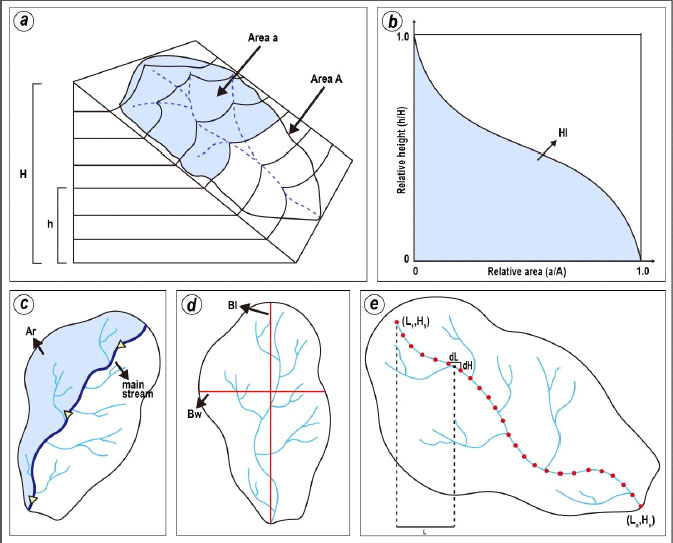
Illustration of geomorphic indices. (a) Schematic diagram showing the principle of Hypsometric Curve (HC; modified from Keller and Pinter, 2002). Area a is the surface area of the drainage basin above a given elevation line h, while area A is the total area. H is the total height. (b) HC graph plotted with the relative height (h/H) against the relative area (a/A) (modified from Strahler, 1952). Hypsometric Integral (HI) can be calculated integrally under the HC graph. (c) Description for calculating Asymmetry Factor (AF; modified from Hare and Gardner, 1985). Ar is the area of the basin to the right of the main stream. (d) Discription of Basin Shape ratio (BS; modified from Cannon, 1976). Bl is the length and Bw is the width of the drainage basin. (e) Description of Stream Length-gradient (SL; modified from Hack, 1973). dL is the distance change and dH is the elevation change between given points along the stream. L is the length from the given midpoint to the highest point on the stream.
2.1 Hypsometr ic analysis
Hypsometric analysis는 HC와 HI로 이루어진 분석방법으로, 유역분지의 고도에 따른 면적분포를 바탕으로 지형의 발달정도를 파악하여 활성도를 평가하는 방법이다(Strahler, 1952). 유역분지의 발달정도를 지시하는 HC는 전체 누적면적에 대한 고도별 분포면적의 비로 나타내며(Langbein et al., 1947; 그림 1a), 가로축을 총 면적에 대한 비, 세로축을 총 고도에 대한 비의 그래프로 표현한다(그림 1b). HC는 유역분지의 발달정도에 따라 활성도 높음에서 낮음 순으로 볼록형(convex), S형(s-shape), 직선형(straight), 오목형(concave)의 4가지로 구분된다. HC 아래 면적을 적분한 값인 지형인자 HI는 유역분지의 고도분포 변화를 나타내며 값이 증가함에 따라 활성도가 높아진다. HI 값은 DEM에서 최대 고도값(Hmax), 최소 고도값(Hmin), 평균 고도값(Hmean)을 추출하여 식 (1)을 통해 도출할 수 있다(Pike and Wilson, 1971).
| (1) |
2.2 Asymmetry Factor (AF)
AF는 유역분지의 경동에 따른 비대칭 정도를 나타내며, 단층의 수직운동에 큰 영향을 받고 암상과 기후의 영향은 거의 없다고 가정한다(Keller and Pinter, 2002). 경동 정도가 클수록 활성도가 높은 AF는 대개 유역분지 주하천(main stream)의 하류방향에 대해 오른쪽 면적(Ar)과 전체 면적(At)의 비(그림 1c)를 Hare and Gardner (1985)의 식을 사용하여 나타내는 것이 일반적이나, 이번 연구에서는 경동 방향에 관계없이 경동 정도로만 활성도를 나타내기 위해 절댓값을 적용한 식 (2)를 이용하였다.
| (2) |
2.3 Basin Shape r atio (BS)
BS는 성숙도에 따른 유역분지의 모양을 나타내는 지형인자로(그림 1d), 식 (3)과 같이 유역분지의 최장 너비를 나타내는 Bw과 최대 길이를 나타내는 Bl의 관계로 정의할 수 있다(Cannon, 1976). BS는 지형 발달에 따른 유역분지의 성숙도와 지구조 활성도가 반비례함을 기반으로 활성도를 직관적으로 평가한다. 유역분지의 성숙도가 감소함에 따라 BS 값이 증가하며 길게 신장되는(elongated) 모양을 가지고, 유역분지의 성숙도 증가에 따라 BS 값이 감소하고 둥근(circular) 모양을 보인다.
| (3) |
2.4 Str eam Length-gr adient (SL)
길이에 따른 하천의 경사 변화도를 나타내는 SL은 암상, 기후, 하천력(stream power), 지구조운동 등 다양한 요인에 영향을 받는다(Hack, 1973). 또한, SL을 통해 하천 종단면의 변화를 나타낼 수 있으며, 하천의 기울기가 급변하는 천이점(knickpoint)을 찾을 수 있다(Hack, 1973). 분석을 위해 모든 유역분지의 주하천에 대해 같은 거리 간격이나 고도 간격으로 점을 생성한 후 식 (4)를 이용하여 SL 값을 도출하였다(Keller and Pinter, 2002; 그림 1e).
| (4) |
여기서, ∆H (dH)는 생성된 점들 사이의 고도 변화, ∆L (dL)은 거리 변화, L은 각각 이웃한 점과의 중심점에서 가장 높은 고도를 가지는 점 사이의 거리이다.
3. 연구지역
한반도 남동부의 음영기복도와 위성지도 상에 북북동 방향의 뚜렷한 선형구조를 만드는 양산단층계는 서쪽에서부터 자인, 밀양, 모량, 양산, 동래, 일광단층으로 구성된다(그림 2). 그중 가장 규모가 큰 양산단층은 약 200 Km 연장과 수백 m 이상의 단층대 폭을 가지며 중생대 이후로 다양한 운동감각으로 다중변형을 겪은 것으로 알려져 있다(Reedman an Um, 1975; Choi et al., 1980; Um et al., 1983; Chang et al., 1990; Hwang et al., 2004, 2007a, 2007b; Cheon et al., 2017, 2019). 특히, 양산단층은 양편의 대비되는 백악기 퇴적암와 화산암류 그리고 알칼리장석 화강암이 현재 우수향으로 뚜렷한 변위를 보이고 있어(Chang et al., 1990; Hwang et al., 2004, 2007a), 다중변형 과정에서 신생대초의 우수향 주향이동 단층운동이 가장 우세하였던 것으로 해석된다. 이번 연구는 청송군 부남면~포항시 남구 오천읍 일원을 지나가는 북부 양산단층을 대상으로 하였다(그림 2b). 단층의 양편에는 백악기 퇴적암류와 화산암류 그리고 이를 관입하는 화강암류가 분포하고, 특히 동편 지괴에는 마이오세의 동해 확장과 관련한 지각변형의 결과인 포항분지의 충전물이 분포한다(Son et al., 2015). 또한 양산단층을 따라 발달하는 단층곡을 따라 제4기 충적층이 퇴적되어 있다.
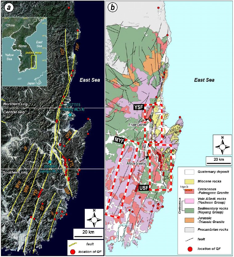
(a) Topographic Landsat TM satellite image map of SE Korea with the location of major faults: Yangsan Fault (YSF), Yeongdeok Fault (YDF), Jain Fault (JF), Miryang Fault (MYF), Moryang Fault (MRF), Dongnae Fault (DF), Ilgwang Fault (IF), Ocheon Fault System (OFS), Yeonil Tectonic Line (YTL), Ulsan Fault (USF), Quaternary Fault (QF) (modified from Kim, Y.-S. et al., 2011; Kim, M.-C. et al., 2016; Choi et al., 2017; Ha et al., 2022) (b) Regional geological map of SE Korea showing major faults (modified from Chang et al., 1990; Hwang, J.H. et al., 1996; Kim et al., 1998; Hwang, B.H. et al., 2007a, 2007b; Son et al., 2015; Song, 2015; Kang et al., 2018; Ha et al., 2022). The study area is marked with the red dashed boxes.
약 60 Km 길이로 경주와 울산을 잇는 북북서 방향의 울산단층과 마이오세 지각변형 서쪽 한계로 알려진 연일구조선 사이에는 역이동 운동감각이 우세한 제4기 단층들이 남-북 내지 북북서 방향으로 발달한다(Okada et al., 1998; Park et al., 2022a). 이번 연구에는 경주시 용강동에서 울산시 방어동까지 울산단층 일원 거의 전체를 대상으로 지형분석이 실시되었다(그림 2b). 이곳에는 백악기 퇴적암류와 화산암류가 분포하고 백악기말~고진기 화강암류가 이를 관입한다. 또한 동쪽 연일구조선 동편에는 마이오세 분지의 충전물이 산출되며, 울산단층을 따라 형성된 저지에는 제4기 충적층이 분포한다.
양산단층계를 구성하는 북북동 방향의 밀양단층은 유천도폭에 따르면 N25°E 주향과 동쪽으로 수직에 가까운 경사 그리고 우수향의 운동감각을 가지는 것으로 알려져 있으나(Hong and Choi, 1988), 단층곡을 따라 제4기 충적층이 두껍게 피복하고 있어 실제 야외에서 단층핵을 관찰하는 것이 쉽지 않다. 이번 연구에서는 밀양단층 거의 전 구간이 포함된 영천시 북안면에서 양산시 원동면 일원을 대상으로 지형분석이 실시되었다. 연구지역은 넓은 분포를 보이는 백악기 화산암류, 북부에 소규모의 백악기 퇴적암류 그리고 이들을 관입한 소규모 백악기말~고진기 화강암체로 구성된다(그림 2b).
양산단층과 울산단층 일원은 제4기 단층의 존재가 다수 보고되어 있어(Okada et al., 1994; Ryoo et al., 1996, 1999, 2001, 2002, 2006; Kyung, 1997, 2003; Chwae et al., 1998; Kyung et al., 1999a, 1999b; Lee, B.J. et al., 1999; Chang, 2001; Kyung and Chang, 2001; Choi, W.-H., 2003; Im et al., 2003; Lee, 2003; Kim, Y.-S. et al., 2004, 2011; Choi, P., 2005; Kim and Jin, 2006; Kee et al., 2007; Kang and Ryoo, 2009; Ryoo, 2009; Choi et al., 2012; Jin et al., 2013; Lee, J. et al., 2015; Kim, M.-C. et al., 2016; Lee, Y. et al., 2017; Song et al., 2020; Ha et al., 2022; Park et al., 2022a, 2022b; 그림 2), 이곳 지형인자 분석 결과는 선행 제4기 단층 연구결과(Ha et al., 2022; Lee et al., 2022; Naik et al., 2022; Park et al., 2022b)와 비교·분석하였다. 한편, 밀양단층 일원은 야외조사를 통해 제4기 단층이 현재까지 보고된 바는 없으나, 최근 다수의 미소지진이 밀양단층을 따라 면상(planar)으로 발생하고 있어(Kim et al., 2022) 과거 중규모 이상의 지진으로 인한 지표변형의 발생 유무가 관심사이다.
양산단층, 울산단층 그리고 밀양단층의 세 연구지역의 단층선은 1:50,000 지질도폭과 기존 연구들을 참고하여 검은색의 기반암 단층과 빨간색의 제4기 단층운동에 의한 지표파열을 구분하여 표기하였다(그림 3; 양산단층: Tateiwa, 1924, 1928; Um et al., 1964; Kim et al., 1968; Kwon and Lee, 1973; Oh and Jeong, 1975; 울산단층: Tateiwa, 1924, 1928; Lee and Kang, 1964; Park and Yoon, 1968a, 1968b; Kim and Jin, 1971; Lee and Lee, 1972; Son et al., 2007; 밀양단층: Tateiwa, 1928; Lee and Kang, 1964; Kim and Jin, 1971; Lee and Lee, 1972; Park and Yoon, 1973; Hong and Choi, 1988; Kim and Hwang, 1988; 지표파열: Ha et al., 2022; Lee et al., 2022; Naik et al., 2022; Park et al., 2022b).
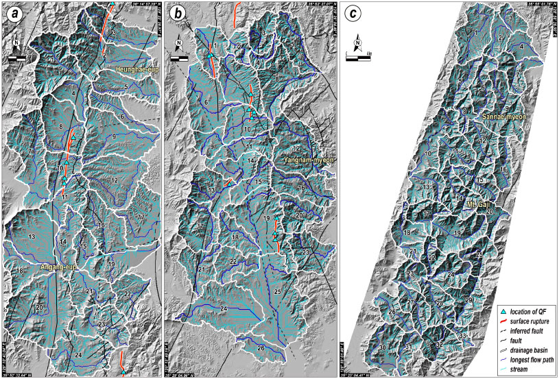
Maps showing drainage basins, streams and longest flow paths of the study area. (a) 24 drainage basins along the Yangsan Fault (modified from Tateiwa, 1924, 1928; Um et al., 1964; Kim et al., 1968; Kwon and Lee, 1973; Oh and Jeong, 1975); (b) 26 drainage basins along the Ulsan Fault (modified from Tateiwa, 1924, 1928; Lee and Kang, 1964; Park and Yoon, 1968a, 1968b; Kim and Jin, 1971; Lee and Lee, 1972; Son et al., 2007); (c) 33 drainage basins along the Miryang Fault (modified from Tateiwa, 1928; Lee and Kang, 1964; Kim and Jin, 1971; Lee and Lee, 1972; Park and Yoon, 1973; Hong and Choi, 1988; Kim and Hwang, 1988). The longest flow paths and streams in each drainage basin are useful for analysis of geomorphic indices. Locations of Quaternary fault (QF) and surface rupture are from Ha et al. (2022), Lee et al. (2022), Naik et al. (2022), and Park et al. (2022b).
4. 연구결과
1:5,000 수치지형도로 구축된 5 m 해상도의 DEM (Digital Elevation Model)을 기반으로 ArcGIS Pro (v.3.0.3)를 활용하여 연구지역의 수계와 유역분지를 추출하였다. 하천정의(stream definition) 임계값에 대해 셀 갯수 5,000,000으로 유역분지를 산출하고, 각 유역분지에 고차수 하천이 포함되도록 설정하였으며, 그 결과 양산단층, 울산단층, 밀양단층을 따라 각각 24개, 26개, 33개의 유역분지가 분류되었다(그림 3). 세 연구지역이 모두 동일한 기후를 가지며, 암상과 지구조운동이 지형인자를 제어하는 주요인으로 가정하였다.
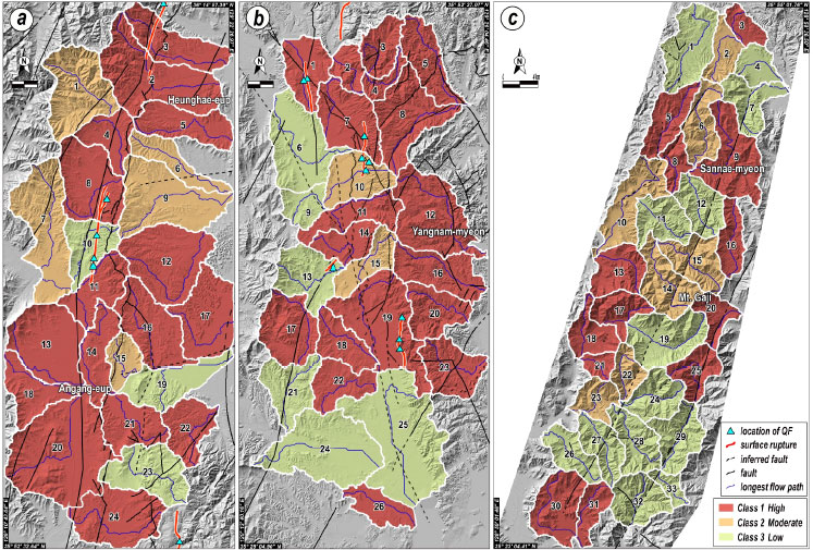
각 지형인자를 특성에 따라 3개 혹은 5개의 등급으로 분류하여 지구조 활성도를 구분하였다. Hypsometric analysis에서 HI는 3개의 등급 즉, 0.5 이상이면 ‘높음(high)’ 활성도(class 1), 0.4 이상 0.5 미만이면 ‘보통(moderate)’ 활성도(class 2), 0.4 미만이면 ‘낮음(low)’ 활성도(class 3)로 구분하였다(El Hamdouni et al., 2008). 분석결과, 양산단층은 24개 유역분지 중 18개가 ‘높음’ 활성도를 보였고 6개가 ‘보통’ 활성도를 보인다(그림 4a; 표 1). 울산단층의 경우, 26개 유역분지 가운데 22개가 ‘높음’ 활성도를 가지고 4개가 ‘보통’ 활성도를 보인다(그림 4b; 표 2). 밀양단층은 33개 유역분지 중 32개가 ‘높음’ 활성도를 보이며 최남단 1개의 유역분지만 ‘보통’ 활성도를 보인다(그림 4c; 표 3). 세 연구지역에서 0.4 미만의 ‘낮음’ 활성도의 HI는 나타나지 않으며 모두 ‘높음’ 활성도가 우세하다.

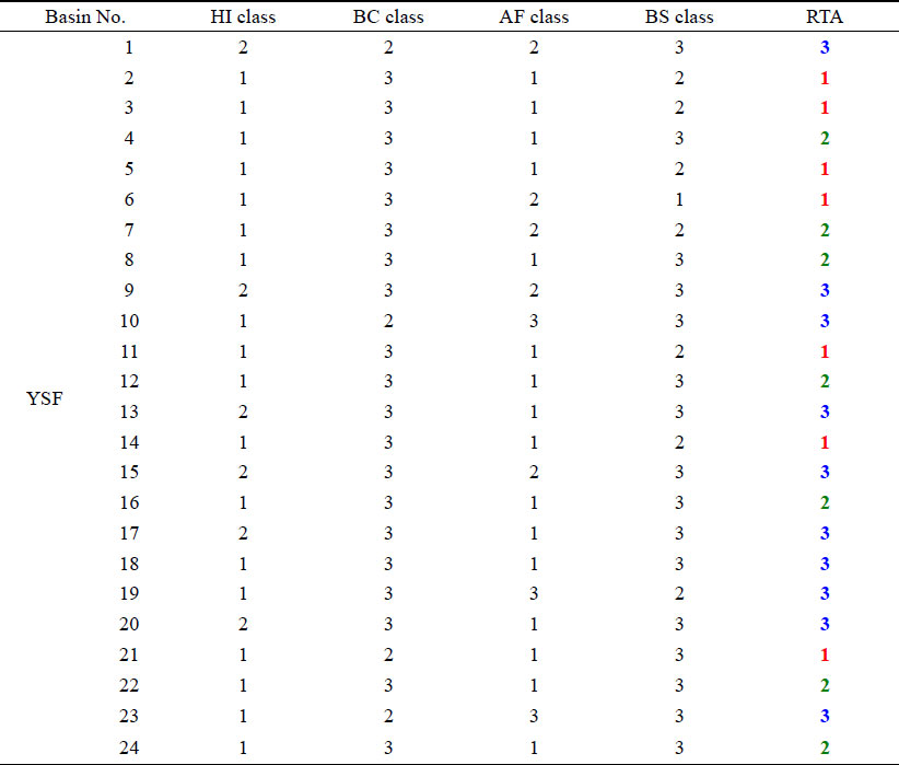
Comprehensive evaluation for Relative Tectonic Activity of the Yangsan Fault based on four geomorphic indices: Hypsometric Integral (HI), Hypsometric Curve (HC), Asymmetry Factor (AF), Basin Shape ratio (BS).

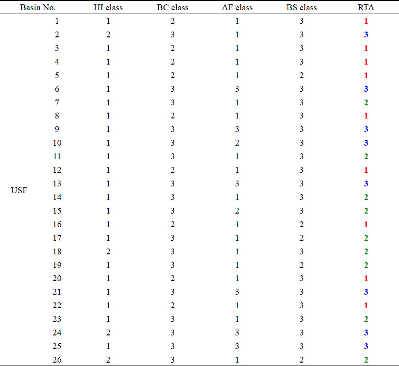
Comprehensive evaluation for Relative Tectonic Activity of the Ulsan Fault based on four geomorphic indices: Hypsometric Integral (HI), Hypsometric Curve (HC), Asymmetry Factor (AF), Basin Shape ratio (BS).

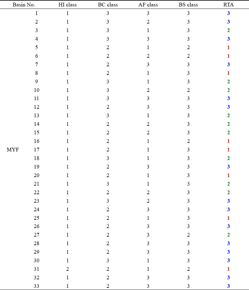
Comprehensive evaluation for Relative Tectonic Activity of the Miryang Fault based on four geomorphic indices: Hypsometric Integral (HI), Hypsometric Curve (HC), Asymmetry Factor (AF), Basin Shape ratio (BS).
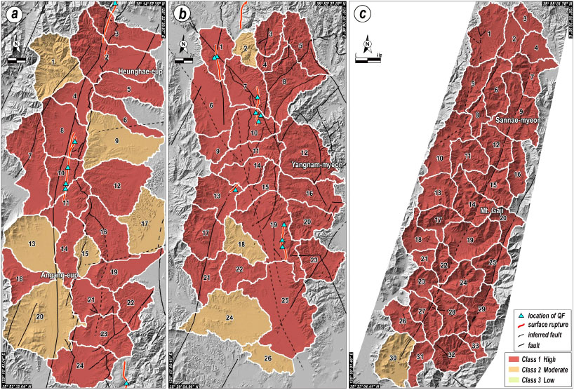
Drainage basins classified by Hypsometric Integral (HI) along (a) the Yangsan, (b) Ulsan, and (c) Miryang faults.
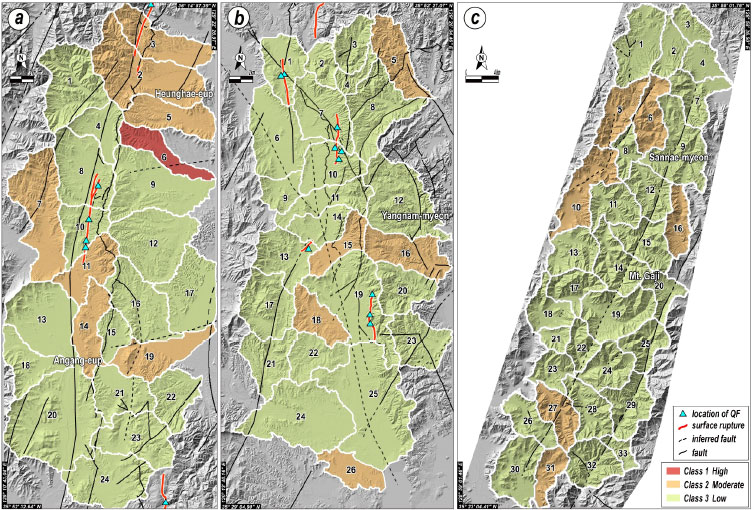
Hypsometric analysis의 HC는 그래프의 모양이 볼록형이면 ‘높음’ 활성도(class 1), S형과 직선형일 경우 ‘보통’ 활성도(class 2), 오목형일 경우에는 ‘낮음’ 활성도(class 3)로 분류하였다(Strahler, 1952). HC 등급 산정결과, 세 연구지역에서 모두 볼록형인 ‘높음’ 활성도는 나타나지 않았다. 양산단층을 따라 S형과 직선형이 각각 2개를 보여 ‘보통’ 활성도의 유역분지가 4개이며, 나머지 20개는 ‘낮음’ 활성도를 보였다(그림 5a; 표 1). 울산단층를 따라 3개의 S형과 6개의 직선형이 나타나 ‘보통’ 활성도의 유역분지가 총 9개이며, 나머지 17개의 유역분지가 ‘낮음’ 활성도를 보였다(그림 5b; 표 2). 밀양단층 일원은 S형이 9개, 직선형이 12개로 ‘보통’ 활성도의 유역분지가 21개이며 나머지 12개는 ‘낮음’ 활성도를 보인다(그림 5c; 표 3). 21개의 ‘보통’ 활성도의 유역분지는 대부분 밀양단층과 인근 모량단층의 곡부를 따라 나타난다.
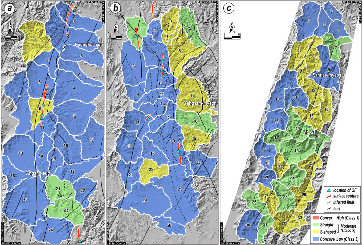
Drainage basins classfied by Hypsometric Curve (HC) along (a) the Yangsan, (b) Ulsan, and (c) Miryang faults.
AF는 10 이상이면 ‘높음’ (class 1), 5 이상 10 미만이면 ‘보통’ (class 2), 5 미만이면 ‘낮음’ 활성도(class 3)의 3개 등급으로 분류하였다(Khalifa et al., 2019). 분석결과, 양산단층 일원에는 16개가 ‘높음’, 5개가 ‘보통’ 그리고 3개의 유역분지가 ‘낮음’ 활성도를 보였다(그림 6a; 표 1). 울산단층을 따라서는 ‘높음’이 18개, ‘보통’이 2개, ‘낮음’ 활성도의 유역분지가 6개 산출되었다(그림 6b; 표 2). 양산단층과 울산단층 일원의 유역분지들은 지형인자 AF에 대해 ‘높음’ 활성도가 우세하다. 한편 밀양단층 일원의 경우에는 ‘높음’과 ‘낮음’ 활성도가 각각 13개로 나타났으며, 7개의 유역분지에서 ‘보통’ 활성도를 보인다(그림 6c; 표 3).
Drainage basins classified by Asymmetry Factor (AF) along (a) the Yangsan, (b) Ulsan, and (c) Miryang faults.
BS는 El Hamdouni et al. (2008)의 기준에 따라 4 이상일 때 ‘높음’ (class 1), 2 이상 4 미만이면 ‘보통’ (class 2), 2 미만이면 ‘낮음’ 활성도(class 3)의 3개 등급으로 분류하였다. 먼저 양산단층을 따라 ‘높음’ 활성도의 유역분지가 1개로 유일하게 나타나며, 나머지는 ‘보통’ 7개와 16개의 ‘낮음’ 활성도의 유역분지로 구성된다(그림 7a; 표 1). 울산단층을 따라서는 5개가 ‘보통’을 그리고 21개의 유역분지가 ‘낮음’의 활성도를 보인다(그림 7b; 표 2). 밀양단층의 경우, ‘보통’ 6개와 ‘낮음’ 활성도의 유역분지 27개가 산출되었다(그림 7c; 표 3). 양산단층 일원에서 나타나는 1개의 ‘높음’ 유역분지를 제외하면, 세 연구지역에서 모두 2 미만의 BS 값이 우세하게 나타나 ‘낮음’ 활성도를 보인다.
Drainage basins classified by Basin Shape ratio (BS) along (a) the Yangsan, (b) Ulsan, and (c) Miryang faults.
SL은 앞선 지형인자들과는 달리 유역분지가 아닌 유역분지 내 주 하천을 기준으로 분석이 이루어진다. 따라서, SL 값은 주 하천을 따라 지점 자료로 도출되며, 값의 등급화를 위해 공간 보간(interpolation) 기법 중 정규 크리깅(ordinary kriging)을 통하여 이를 도시하였다(그림 8). SL에 따른 활성도 등급은 다음과 같다(El Hamdouni et al., 2008).
- - 200 이상: ‘매우 높음(very high)’ 활성도
- - 150 이상 200 미만: ‘높음(high)’ 활성도
- - 100 이상 150 미만: ‘보통(moderate)’ 활성도
- - 50 이상 100 미만: ‘낮음(low)’ 활성도
- - 50 미만: ‘매우 낮음(very low)’ 활성도
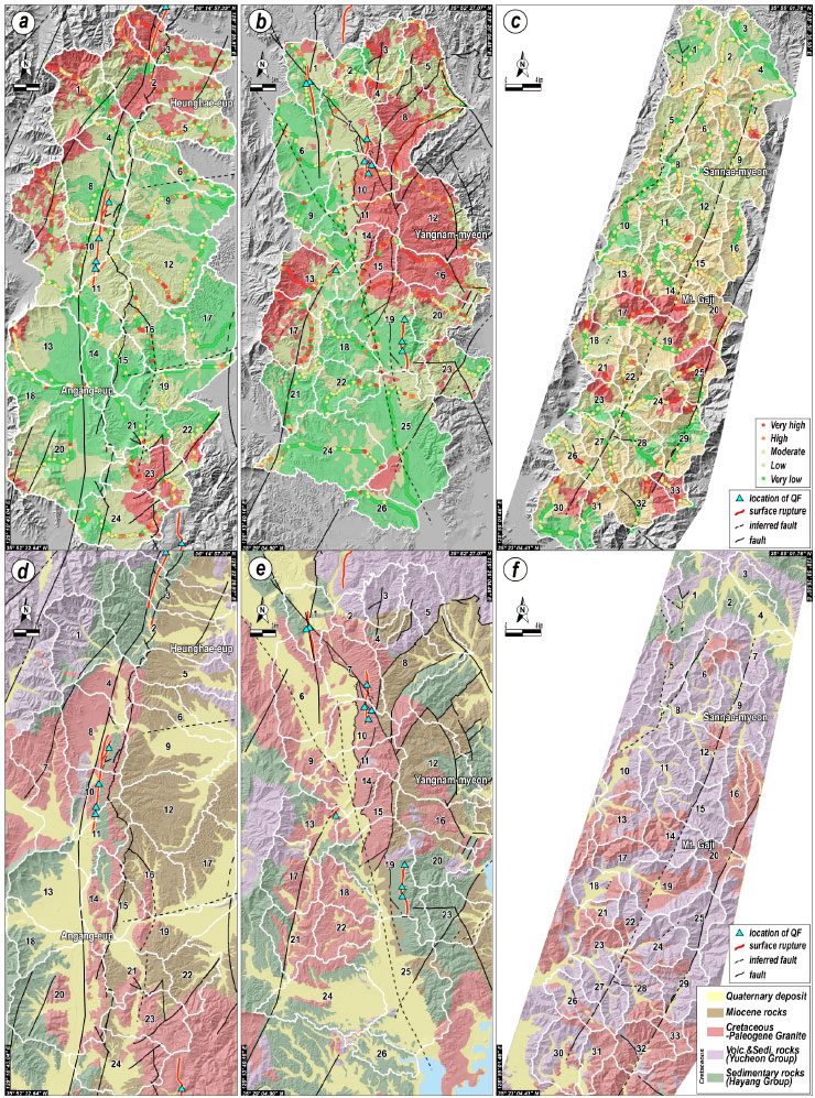
Maps showing the distribution of graded Stream Length-gradient (SL) values (points) obtained along the main streams and their interpolation in the vicinities of (a) the Yangsan, (b) Ulsan, and (c) Miryang faults. Detailed geological maps in the vicinities of (d) the Yangsan fault (modified from Tateiwa, 1924, 1928; Um et al., 1964; Kim et al., 1968; Kwon and Lee, 1973; Oh and Jeong, 1975), (e) the Ulsan fault (modified from Tateiwa, 1924, 1928; Lee and Kang, 1964; Park and Yoon, 1968a, 1968b; Kim and Jin, 1971; Lee and Lee, 1972; Son et al., 2007), and (f) the Miryang fault (modified from Tateiwa, 1928;Lee and Kang, 1964; Kim and Jin, 1971; Lee and Lee, 1972; Park and Yoon, 1973; Hong and Choi, 1988; Kim and Hwang, 1988).
양산단층을 따라서는 연구지역의 북부와 남부에서 산출되는 ‘높음’ 또는 ‘매우 높음’ 활성도 지역을 제외하면 대부분 지역에서 ‘낮음’과 ‘매우 낮음’ 등급이 고르게 나타난다(그림 8a). 또한 울산단층의 SL 값도 ‘높음’ 또는 ‘매우 높음’을 보이는 북동부의 마이오세 분지지역 그리고 동편의 동래단층 북단을 제외하면, 대부분 지역에서 ‘매우 낮음’ 또는 ‘낮음’ 활성도가 넓게 산출되었다(그림 8b). 두 단층과 달리 밀양단층의 경우에는 연구지역 중부와 남부 일부 지역을 제외하면 ‘보통’ 등급의 SL 값이 우세하게 관찰된다(그림 8c).
5. 토 의
지형인자들은 구성요소, 분석방법, 내포된 의미 등이 서로 다르므로 같은 유역분지에서 얻어진 결과라 해도 인자별 특성에 따라 등급이 달라질 수 있다. 이번 연구에서 사용된 지형인자 HI, HC, AF, BS는 모두 유역분지를 3등급으로 구분하는데, 이들을 종합·해석하기 위하여 4가지 지형인자별 등급의 평균값을 이용해 상대적 지구조 활성도(Relative Tectonic Activity, RTA)를 구하였다(El Hamdouni et al., 2008). 각 유역분지의 RTA를 3개의 등급 즉, 1.75 이하이면 ‘매우 높음(very high)’ (class 1), 1.75 초과 2 이하이면 ‘높음(high)’ (class 2), 2를 초과하면 ‘보통(moderate)’ 활성도(class 3)로 분류하였다.
양산단층 일원의 유역분지들에 대한 RTA 산정결과, ‘매우 높음’과 ‘높음’ 활성도를 보이는 것이 각각 7개로 나타났으며, 10개가 ‘보통’ 활성도를 보였다. 이중 제4기 지표파열(Ha et al., 2022; Lee et al., 2022)이 확인된 2, 3, 8, 10, 11번 유역분지 중 10번을 제외하면 모두 ‘높음’ 이상의 활성도를 보인다(그림 9a; 표 1). 또한 ‘매우 높음’을 보이는 유역분지들이 대부분 양산단층의 동편에 위치하고 있어 단층을 중심으로 활성도의 비대칭성을 보여준다. 이러한 비대칭성은 북북동 방향의 양산단층을 따라 발견된 제4기 단층들이 대부분 동쪽으로 경사지고 우수향 주향이동과 함께 동편 지괴가 충상된 역이동 성분을 포함하고 있어(Kyung et al., 1999a, 1999b; Kim and Jin, 2006; Kim et al., 2016; Song et al., 2020; Ha et al., 2022; Lee et al., 2022), 양산단층의 동쪽 지괴가 서쪽에 비해 보다 활발한 신기 지각변형을 겪었음을 보여주는 결과일 수 있다.
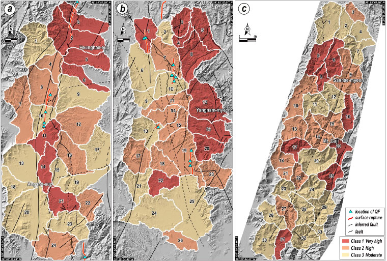
Drainage basins classified by Relative Tectonic Activity (RTA) along (a) the Yangsan, (b) Ulsan, and (c) Miryang faults.
울산단층 일원은 각각 9개의 유역분지가 ‘매우 높음’과 ‘높음’의 활성도를 보이며 8개에서 ‘보통’의 활성도가 산출되었다. 이곳에서 확인된 제4기 지표파열(Park et al., 2022b)은 1번 유역분지를 제외하면 ‘매우 높음’ 활성도와 무관하게 위치한다. 그러나 양산단층 일원과 유사하게 울산단층 일원의 ‘매우 높음’의 유역분지들이 대부분 울산단층의 동편에 집중되어 분포함은 특이하다(그림 9b; 표 2). 이러한 비대칭성은 RTA뿐만 아니라 HC, AF와 SL 보간 결과에서도 관찰된다(그림 5b, 6b, 8b). 울산단층 일원의 제4기 단층들은 남북 내지 북북서 주향으로 동쪽의 상반 지괴가 서쪽으로 충상하는 역이동성 운동감각을 보이며 주로 울산단층 동편에서 발견되었다(Kyung, 2010; Choi et al., 2012; Park et al., 2022a, 2022b). 또한, Seo (2021)에 의하면 울산단층 동편은 지진다발지역으로 동북동-서남서 압축력에 의한 역이동성 단층운동이 활발함을 보고하고 있어, 울산단층 일원의 비대칭적 활성도 분포는 동쪽 지괴의 융기와 상대적으로 활발한 지각변형과 관계할 가능성이 높다.
밀양단층 일원의 RTA는 ‘매우 높음’ 활성도의 유역분지가 8개, ‘높음’ 활성도가 10개, ‘보통’이 15개로, 양산단층과 울산단층 일원에 비해 ‘보통’의 유역분지 비율이 높다(그림 9c; 표 3). ‘매우 높음’ 활성도의 유역분지는 밀양단층의 일부 구간과 함께 서편의 자인단층과 동편의 모량단층을 따라 분산되어 나타나며, 밀양단층을 중심으로 양편의 활성도에서 눈에 띄는 비대칭성이 인지되지 않는다. 한편, 현재까지 밀양단층을 따라 제4기 단층노두나 지표파열이 확인된 바는 없으나, 최근 연구(Kim et al., 2022)는 밀양단층 바로 지하에서 단층과 평행하고 거의 수직한 경사를 가진 면상에서 지진들이 다발로 발생하고 있음을 보고하였다. 이러한 사실들을 종합하면, 밀양단층을 따라 현재 작은 규모의 지진들이 다수 발생하고 있기는 하나, 제4기 또는 최근 지질시대 동안 지표를 변형 또는 파열시킬 정도로 큰 지진이 밀양단층에서 발생하지 않아 지형인자에서 활성도의 비대칭성이 관찰되지 않을 가능성이 있다.
이번 연구에서 RTA 산정에 포함되지 않은 SL 값은 기반암의 암상에 영향을 많이 받기 때문에 지구조 활성도 평가에 있어 주의가 필요하다. 일반적으로 SL은 퇴적암에서 낮고, 화성암과 변성암에서 높은 값을 보인다(Hack, 1973). 상대적으로 넓게 분포하는 백악기 퇴적암류와 마이오세 퇴적암류 그리고 백악기 화산암류와 화강암류가 산재되어 나타나는 양산단층과 울산단층 일원의 SL 값은 50 이하의 낮은 값이 우세한 반면(그림 8a, 8b, 8d, 8e), 백악기 화산암류가 주를 이루는 밀양단층 일원의 SL은 100 이상의 높은 값을 보여주고 있어(그림 8c, 8f), 암상에 따른 기존 SL 연구결과와 잘 부합한다. 암상에 따른 SL 값들은 고도와 상관없이 같은 암상에서 비교적 일정한 값을 보여주는 것이 일반적이나, 이들 중 눈에 띄게 높은 값이 인지되는 부분을 SL 이상대(SL anomaly)로 정의된다. 이러한 이상대는 급격한 암상의 변화 또는 지구조운동에 의한 천이점 즉, 지진에 의한 지표변형을 찾는데 중요한 실마리가 될 수 있다. 이번 세 연구지역의 유역분지 내 주하천을 따라 다수의 SL 이상대가 관찰되었다. 이중 일부는 제4기 지표파열과 지질도폭에 표시된 기존 단층의 위치와 거의 일치한다. 연구지역 유역분지의 주하천에 따른 고도 변화와 SL 값의 변화를 비교하여 그래프로 도시한 결과, 특히 양산단층의 유역분지 2와 울산단층의 유역분지 10에서 고도와 SL 값이 급격히 변화하는 지점이 근사하게 위치하였고, 이곳에 제4기에 발생한 지표파열 단층이 지나가고 있다(그림 10). 이는 지형인자 SL 이상대가 최근에 지구조운동이 발생한 지역을 찾고 새로운 활성단층지도를 작성하는데 있어 사전 예비자료로 충분히 활용될 수 있음을 보여준다.
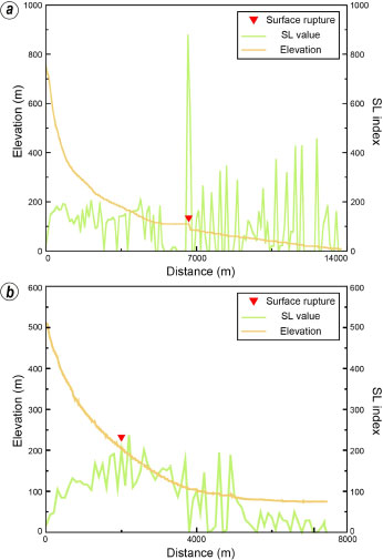
Stream Length-gradient (SL) values and the locations of fault or surface rupture plotted on the longitudinal profiles along main streams in (a) drainage basin No. 2 of the Yangsan Fault and (b) drainage basin No. 10 of the Ulsan Fault.
이번 연구에 사용된 지형인자들은 높은 신뢰성과 적용성을 보이는 해외사례(El Hamdouni et al., 2008; Khalifa et al., 2019)를 기반으로 분석되었고 분석결과는 기존 신기 지각변형 연구(Ha et al., 2022; Lee et al., 2022; Naik et al., 2022; Park et al., 2022b)와 상당히 부합하는 양상을 보였다. 따라서 향후 국내 다른 여러 지역에 대한 분석을 통해 새로운 지형인자를 개발하거나, RTA 산정 시 AHP (Analytical Hierarchy Process)와 JA (Judgement Analysis), Swing (Swing weight method)과 같은 가중치(weight) 추출기법을 적용하여 보다 신뢰도 높은 활성도 평가로 개선될 수 있다. 또한, 지형인자 분석의 기본 데이터베이스인 DEM 구축 시 높은 해상도와 정밀도를 기반으로 하는 LiDAR 자료를 토대로 분석을 진행한다면 더욱 신뢰성 있는 지구조 활성도 평가결과를 도출할 수 있을 것으로 기대된다.
6. 결 론
지형인자 분석은 넓은 지역을 대상으로 구역별 지구조 활성도를 빠르게 평가하여 정량적으로 표현할 수 있다. 한반도 남동부에 위치한 양산단층, 울산단층, 밀양단층 주변의 유역분지들에 대해 지형인자 Hypsometric Integral (HI), Hypsometric Curve (HC), Asymmetry Factor (AF), Basin Shape ratio (BS), Stream Length-gradient (SL)를 사용하여 활성도 분석을 진행하였고 인자별 등급을 종합하여 상대적 지구조 활성도 (RTA)를 산정하였다. 주요 결과는 다음과 같다(표 1).
1) 양산단층은 모두 0.4 이상의 HI 값을 보여 70%의 유역분지가 ‘높음’ 활성도를 보인다. HC의 경우, 오목형 그래프가 우세하여 80%의 유역분지가 ‘낮음’ 활성도를 나타낸다. AF는 75%의 유역분지가 ‘높음’ 활성도를 보이고, 60%의 유역분지가 BS에 대해 ‘낮음’ 활성도를 보인다.
2) 울산단층의 HI는 유역분지 85%가 ‘높음’ 활성도를 보이지만, HC는 65%가 ‘낮음’ 활성도를 나타낸다. 울산단층의 AF는 유역분지 70%가 ‘높음’ 활성도에 해당하고, BS의 경우 60%가 ‘낮음’ 활성도를 나타낸다.
3) 밀양단층 또한 HI가 0.4 이상으로, 94%의 유역분지가 ‘높음’ 활성도를 보이고 유역분지 65%가 HC ‘낮음’ 활성도를 나타낸다. AF는 ‘높음’, ‘보통’, ‘낮음’ 활성도가 고르게 나타나며, BS에 대해 81%의 유역분지가 ‘낮음’ 활성도를 보인다.
4) RTA 종합결과, 제4기 지표파열과 단층들이 다수 보고된 양산단층과 울산단층 일원은 상대적으로 높은 활성도가 나타났으며, 단층을 기준으로 동쪽 유역분지의 활성도가 더 높은 비대칭적인 활성도 분포를 보였다. 반면 다수의 미소지진이 보고되지만 제4기 단층의 존재가 알려지지 않은 밀양단층 일원의 유역분지는 많은 수가 ‘보통’의 활성도를 보였고 단층을 기준으로 동쪽과 서쪽 지괴의 활성도가 유사한 대칭성을 보여주었다.
5) 주하천을 따라 분석된 SL 값은 기반암의 암상에 많은 영향을 받으나 일부 구간에서 암상에 따른 일반적인 값에서 벗어나는 이상대가 존재함이 확인되었다. 이들 이상대는 빠른 고도 변화 지점 그리고 제4기 지표파열 단층과 근사하게 위치하기 때문에 향후 활발한 신기 지각변형 지역과 활성단층을 찾는데 있어 예비자료로 활용될 수 있을 것으로 판단된다.
Acknowledgments
이 연구는 행정안전부 지진 위험분석 및 관리기술 개발사업(2022-MOIS62-001)과 한국기상산업기술원 강원 내륙 및 동해 중부해역 지하 단층구조 분석사업(KMI2022-00610)의 지원을 받아 수행되었습니다. 세심한 심사와 건설적인 조언을 해주신 익명의 심사위원분들께 감사드립니다.
References
-
Baioni, D., 2016, Analysis of Drainage Basin Asymmetry in the Ventena River, Northern Apennines (Central Italy). International Journal of Earth and Environmental Sciences, 1, 1-5.
[https://doi.org/10.15344/2456-351X/2016/121]

- Cannon, P.J., 1976, Generation of explicit parameters for a quantitative geomorphic study of Mill Creek Drainage Basin. Oklahoma Geology Notes, 36, 3-16.
- Chang, K.H., Woo, B.G., Lee, J.H., Park, S.O. and Yao, A., 1990, Cretaceous and early Cenozoic stratigraphy and history of eastern Kyongsang Basin, S. Korea. Journal of the Geological Society of Korea, 26, 471-487.
- Chang, T.W., 2001, Quaternary tectonic activity at the eastern block of the Ulsan fault. Journal of the Geological Society of Korea, 37, 431-444 (in Korean with English abstract).
-
Cheon, Y., Cho, H., Ha, S., Kang, H.-C., Kim, J.-S. and Son, M., 2019, Tectonically controlled multiple stages of deformation along the Yangsan Fault Zone, SE Korea, since Late Cretaceous. Journal of Asian Sciences, 170, 188-207.
[https://doi.org/10.1016/j.jseaes.2018.11.003]

-
Cheon, Y., Ha, S., Lee, S., Cho, H. and Son, M., 2017, Deformation features and history of the Yangsan Fault Zone in the Eonyang-Gyeongju area, SE Korea. Journal of the Geological Society of Korea, 53, 95-114 (in Korean with English abstract).
[https://doi.org/10.14770/jgsk.2017.53.1.95]

- Choi, H.I., Oh, J.H., Shin, S.C. and Yang, M.Y., 1980, Geology and geochemistry of the Gyeongsang strata in Ulsan area. Korea Institute of Energy and Resources Bulletin, 20, 33 p (in Korean with English abstract).
-
Choi, J.-H., Kim, Y.-S. and Klinger, Y., 2017, Recent progress in studies on the characteristics of surface rupture associated with large earthquakes. Journal of the Geological Society of Korea, 53, 129-157 (in Korean with English abstract).
[https://doi.org/10.14770/jgsk.2017.53.1.129]

- Choi, P., 2005, Geometric analysis of the Quaternary Eupchon Fault: An interpretation of trench sections. Journal of the Geological Society of Korea, 41, 129-140 (in Korean with English abstract).
- Choi, S.-J., Jeon, J.-S., Song, K.-Y., Kim, H.-C., Kim, Y.-H., Choi, P.-Y., Chwae, U.C., Han, J.-G., Ryoo, C.-R., Sun, C.-G., Jeon, M.S., Kim, G.-Y., Kim, Y.-B., Lee, H.-J., Shin, J.S., Lee, Y.-S. and Kee, W.-S., 2012, Active faults and seismic hazard map. National Emergency Management Agency, Seoul, 882 p.
- Choi, W.-H., 2003, Neotectonics of the Gyeongju-Ulsan area in the southeastern part of Korean Peninsula. Ph.D. thesis, Seoul National University, Seoul, 205 p (in Korean with English abstract).
- Chwae, U. and 57 others, 1998, Final report of the re-evaluation to the design base earthquake considering the Yangsan Fault. Korea Institute of Geology, Mining and Materials, Korea Electric Power Corporation, 435 p.
-
Cox, R.T., Van Arsdale, R.B. and Harris, J.B., 2001, Identification of possible Quaternary deformation in the northeastern Mississippi Embayment using quantitative geomorphic analysis of drainage-basin asymmetry. Geological Society of America Bulletin, 113, 615-624.
[https://doi.org/10.1130/0016-7606(2001)113<0615:IOPQDI>2.0.CO;2]

-
El Hamdouni, R., Irigaray, C., Fernandez, T., Chacón, J. and Keller, E.A., 2008, Assessment of relative active tectonics, southwest border of the Sierra Nevada (Southern Spain). Geomorphology, 96, 150-173.
[https://doi.org/10.1016/j.geomorph.2007.08.004]

-
Ha, S., Son, M. and Seong, Y.B., 2022, Active Fault Trace Identification Using a LiDAR High-Resolution DEM: A Case Study of the Central Yangsan Fault, Korea. Remote Sensing, 14, 4838.
[https://doi.org/10.3390/rs14194838]

- Hack, J.T., 1973, Stream-profile analysis and stream-gradient index. Journal of Research of the U.S. Geological Survey, 1, 421-429.
- Hare, P.W. and Gardner, T.W., 1985, Geomorphic indicators of vertical neotectonism along converging plate margins, Nicoya Peninsula, Costa Rica. Tectonic geomorphology, 4, 75-104.
- Hong, S.H. and Choi, P.Y., 1988, Geological report of the Yuchon sheet (1:50,000). Korea Institute of Energy and Resources, 26 p (in Korean with English abstract).
- Hwang, B.H., Lee, J.D. and Yang, K., 2004, Petrological study of the granitic rocks around the Yangsan fault: Lateral displacement of the Yangsan fault. Journal of the Geological Society of Korea, 40, 161-178 (in Korean with English abstract).
-
Hwang, B.H., Lee, J.D., Yang, K. and McWilliams, M., 2007a, Cenozoic strike-slip displacement along the Yangsan fault, southeast Korean Peninsula. International Geology Review, 49, 768-775.
[https://doi.org/10.2747/0020-6814.49.8.768]

-
Hwang, B.H., McWilliams, M., Son, M. and Yang, K., 2007b, Tectonic implication of A-type granites across the Yangsan fault, Gigye and Gyeongju areas, southeast Korean Peninsula. International Geology Review, 49, 1094-1102.
[https://doi.org/10.2747/0020-6814.49.12.1094]

- Hwang, J.H., Kim, D.H., Cho, D.R. and Song, K.Y., 1996, Explanatory Note of The Andong Sheet, 1:1:250,000. Korea Institute of Geoscience and Mineral Resources, 67 p.
- Im, C.B. and 150 others, 2003, Development of technology and background for seismic safety evaluation. Korea Institute of Nuclear Safety, Daejeon, 1433 p (in Korean with English abstract).
- Jin, K., Kim, Y.-S., Kang, H.C. and Shin, H.C., 2013, Study on developing characteristics of the Quaternary Gusan Fault in Uljin, Gyeongbuk, Korea. Journal of the Geological Society of Korea, 49, 197-207 (in Korean with English abstract).
- Kang, H.-C., Cheon, Y., Ha, S., Seo, K., Kim, J.-S., Shin, H.C. and Son, M., 2018, Geology and U-Pb age in the eastern part of Yeongdeok-gun, Gyeongsangbuk-do, Korea. Journal of the Petrological Society of Korea, 27, 153-171 (in Korean with English abstract).
- Kang, J.-H. and Ryoo, C.-R., 2009, The movement history of the southern part of the Yangsan Fault Zone interpreted from the geometric and kinematic characteristics of the Sinheung Fault, Eonyang, Gyeongsang Basin, Korea. Journal of the Petrological Society of Korea, 18, 19-30 (in Korean with English abstract).
- Kee, W.-S., Kim, B.C., Hwang, J.H., Song, K.-Y. and Kim, Y.-H., 2007, Structural characteristics of Quaternary reverse faulting on the Eupcheon Fault, SE Korea. Journal of the Geological Society of Korea, 43, 311-333 (in Korean with English abstract).
- Keller, E.A. and Pinter, N., 2002, Active tectonics: earthquakes, uplift, and landscape. Prentice Hall, New Jersey, 362 p.
- Khalifa, A., Çakir, Z., Owen, L.A. and Kaya, Ş., 2019, Evaluation of the Relative Tectonic Activity of the Adiyaman fault within the Arabian-Anatolian plate boundary (Eastern Turkey). Geologica Acta, 17, 1-17.
- Kim, D.H., Hwang, J.H., Park, K.H. and Song, K.Y., 1998, Explanatory Note of The Pusan sheet (1:250,000). Korea Institute of Energy and Resources, 62 p.
- Kim, K.B. and Hwang, S.K., 1988, Geological report of the Miryang sheet (1:50,000). Korea Institute of Energy and Resources, 26 p (in Korean with English abstract).
- Kim, K.H., Kang, S.Y., Lee, Y.C., Sohn, Y.J. and Kim, D., 2022, Monitoring of microearthquakes and subsurface fault structure in Yeongnam region. Joint Conference of the Geological Science & Technology of Korea (Abstracts), Gwangju, June 21-24, 55 p (in Korean).
-
Kim, M.-C., Jung, S., Yoon, S., Jeong, R.-Y., Song, C.W. and Son, M., 2016, Neotectonic Crustal Deformation and Current Stress Field in the Korean Peninsula and Their Tectonic Implications: A Review. Journal of the Petrological Society of Korea, 3, 169-193 (in Korean with English abstract).
[https://doi.org/10.7854/JPSK.2016.25.3.169]

- Kim, N.J. and Jin, M.S., 1971, Explanatory text of the geological map of Moryang sheet (1:50,000). Geological Survey of Korea, 19 p (in Korean with English abstract).
- Kim, O.J., Yoon, S. and Gil, Y.J., 1968, Explanatory text of the geological map of Cheongha sheet (1:50,000). Geological Survey of Korea, 36 p (in Korean with English abstract).
- Kim, Y.-S. and Jin, K., 2006, Estimated earthquake magnitude from the Yugye Fault displacement on a trench section in Pohang, SE Korea. Journal of the Geological Society of Korea, 42, 79-94 (in Korean with English abstract).
- Kim, Y.-S., Jin, K., Choi, W.-H. and Kee, W.-S., 2011, Understanding of active faults: A review for recent researches. Journal of the Geological Society of Korea, 47, 723-752 (in Korean with English abstract).
-
Kim, Y.-S., Park, J.Y., Kim, J.H., Shin, H.C. and Sanderson, D.J., 2004, Thrust geometries in unconsolidated Quaternary sediments and evolution of the Eupchon Fault, southeast Korea. The Island Arc, 13, 403-415.
[https://doi.org/10.1111/j.1440-1738.2004.00435.x]

-
Kim, Y.-S., Son, M., Choi, J.H., Choi, J.H., Seong, Y.B. and Lee, J., 2020, Processes and challenges for the production of Korean active faults map. Journal of the Geological Society of Korea, 56, 113-134 (in Korean with English abstract).
[https://doi.org/10.14770/jgsk.2020.56.2.113]

- Kwon, Y.I. and Lee, I.K., 1973, Explanatory text of the geological map of Dopyeong sheet (1:50,000). Geological and Mineral Institute of Korea, 9 p (in Korean with English abstract).
- Kyung, J.B., 1997, Paleoseismological study on the midnorthern part of Ulsan Fault by trench method. The Journal of Engineering Geology, 7, 81-90 (in Korean with English abstract).
- Kyung, J.B., 2003, Paleoseismology of the Yangsan Fault, southeastern part of the Korean peninsula. Annals of Geophysics, 46, 983-996.
- Kyung, J.B., 2010, Paleoseismological study and evaluation of maximum earthquake magnitude along the Yangsan and Ulsan Fault Zones in the Southeastern Part of Korea. Geophysics and Geophysical Exploration, 13, 187-197.
- Kyung, J.B. and Chang, T.W., 2001, The latest fault movement on the northern Yangsan fault zone around the Yugye-ri area, southeast Korea. Journal of the Geological Society of Korea, 37, 563-577 (in Korean with English abstract).
- Kyung, J.-B., Lee, K. and Okada, A., 1999a, A paleoseismological study of the Yangsan fault - analysis of deformed topography and trench survey. Journal of the Korean Geophysical Society, 2, 155-168 (in Korean with English abstract).
- Kyung, J.-B., Lee, K., Okada, A., Watanabe, M., Suzuki, Y. and Takemura, K., 1999b, Study of fault characteristics by trench survey in the Sangchon-ri area in the southern part of Yangsan fault, southeastern Korea. Journal of Korean Earth Science Society, 20, 101-110 (in Korean with English abstract).
- Langbein, W.B. et al., 1947, Topographic characteristics of drainage basins. United States Government Printing Office Washington, United States, 36 p.
- Lee, B.J., Ryoo, C.-R. and Chwae, U., 1999, Quaternary faults in the Yangnam area, Kyongju, Korea. Journal of the Geological Society of Korea, 35, 1-14 (in Korean with English abstract).
-
Lee, J., Rezaei, S., Hong, Y., Choi, J.-H., Choi, J.-H., Choi, W.-H., Rhee, K.-W. and Kim, Y.-S., 2015, Quaternary fault analysis through a trench investigation on the northern extension of the Yangsan fault at Dangu-ri, Gyungju-si, Gyeongsanbuk-do. Journal of the Geological Society of Korea, 51, 471-485 (in Korean with English abstract).
[https://doi.org/10.14770/jgsk.2015.51.5.471]

- Lee, M.S. and Kang, P.C., 1964, Explanatory text of the geological map of Yangsan sheet (1:50,000). Geological Survey of Korea, 43 p (in Korean with English abstract).
-
Lee, S., Han, J., Ha, S., Lim, H.W., Seong, Y.B., Choi, J.-H., Lee, C.H., Kim, S.-J., Kang, H.-C., Kim, M.-C., Lim, H.J. and Son, M., 2022, Characteristics of the Quaternary faulting detected along the Yangsan Fault in Yugye- and Jungsan-ri, northern Pohang City. Journal of the Geological Society of Korea, 58, 427-443 (in Korean with English abstract).
[https://doi.org/10.14770/jgsk.2022.58.4.427]

-
Lee, Y., Cheon, Y., Ha, S., Kang, H.-C., Choi, J.-H. and Son, M., 2017, Geometric and kinematic characteristics of the Quaternary fault at Seooe site, in Goseong-gun, Gyeongsangnam-do. Journal of the Geological Society of Korea, 53, 115-127 (in Korean with English abstract).
[https://doi.org/10.14770/jgsk.2017.53.1.115]

- Lee, Y.H., 2003, Quaternary faults in the eastern area of the Ulsan fault (Korea). M.S. thesis, Pusan National University, Busan, 74 p (in Korean with English abstract).
- Lee, Y.J. and Lee, I.K., 1972, Explanatory text of the geological map of Eonyang sheet (1:50,000). Geological Survey of Korea, 22 p (in Korean with English abstract).
-
Mahmood, S.A. and Gloaguen, R., 2012, Appraisal of active tectonics in Hindu Kush: Insights from DEM derived geomorphic indices and drainage analysis. Geoscience Frontiers, 3, 407-428.
[https://doi.org/10.1016/j.gsf.2011.12.002]

-
Moumeni, M., Nozaem, R. and Dehbozorgi, M., 2021, Quantitative assessment of the relative tectonic activity using the analytical hierarchy process in the northwestern margin of the Lut Block, Central Iran. Journal of Asian Earth Sciences, 206, 17 p.
[https://doi.org/10.1016/j.jseaes.2020.104607]

-
Naik, S.P., Gwon, O., Park, K., Bae, S.Y., Shin, H.C., Choi, J.H. and Kim, Y.S., 2022, Localization and characterization of the southern Ulsan fault (UF) using geo-electrical imaging: Implication for seismic hazard assessment in an urbanized area. Journal of Geodynamics, 151, 101919.
[https://doi.org/10.1016/j.jog.2022.101919]

- Oh, I.S. and Jeong, G.S., 1975, Explanatory text of the geological map of Gigae sheet (1:50,000). Geological and Mining Institute of Korea, 25 p (in Korean with English abstract).
-
Okada, A., Watanabe, M., Sato, H., Jun, M.-S., Jo, W.-R., Kim, S.-K., Jeon, J.-S., Chi, H.-C. and Oike, K., 1994, Active fault topography and trench survey in the central part of the Yangsan fault, Southeast Korea. Journal of Geography (Chigaku Zasshi), 103, 111-126 (in Japanese with English abstract).
[https://doi.org/10.5026/jgeography.103.2_111]

-
Okada, A., Watanabe, M., Suzuki, Y., Kyung, J.-B., Jo, W.-R., Kim, S.-K., Oike, K. and Nakamura, T., 1998, Active fault topography and fault outcrops in the central part of the Ulsan fault system, southeast Korea. Journal of Geography (Chigaku Zasshi), 107, 644-658 (in Japanese with English abstract).
[https://doi.org/10.5026/jgeography.107.5_644]

- Park, B.S. and Yoon, Y.Y., 1973, Explanatory text of the geological map of Jain sheet (1:50,000). Korea Institute of Energy and Resources, 27 p (in Korean with English abstract).
-
Park, K., Prasanajit, N.S., Gwon, O., Shin, H.C. and Kim, Y.S., 2022a, Characterization of Fault Kinematics based on Paleoseismic Data in the Malbang area in the Central Part of the Ulsan Fault Zone. Journal of the Korean earth science society, 43, 151-164 (in Korean with English abstract).
[https://doi.org/10.5467/JKESS.2022.43.1.151]

- Park, K., Prasanajit, N.S., Gwon, O., Shin, H.C. and Kim, Y.S., 2022b, Paleoseismic characteristic of active faults along the Ulsan fault zone. The Korean Society of Engineering Geology 2022 Fall Conference (Abstracts), Gyeongju, November 10-11, 34 p (in Korean).
- Park, S.J., 2007, Tectonic movement in the Korean Peninsula (I): The spatial distribution of tectonic movement identified by terrain analyses. Journal of the Korean Geographical Society, 42, 368-387 (in Korean with English abstract).
- Park, Y.D. and Yoon, H.D., 1968a, Explanatory text of the geological map of Ulsan sheet (1:50,000). Geological Survey of Korea, 36 p (in Korean with English abstract).
- Park, Y.D. and Yoon, H.D., 1968b, Explanatory note of the geological map of Bangeujin sheet (1:50,000). Geological Survey of Korea, 14 p (in Korean with English abstract).
-
Partabian, A., Nourbakhsh, A. and Ameri, S., 2016, GIS-based evaluation of geomorphic response to tectonic activity in Makran Mountain Range, SE of Iran. Geosciences Journal, 20, 921-934.
[https://doi.org/10.1007/s12303-016-0106-x]

-
Pérez-Peña, J.V., Azor, A., Azañón, J.M. and Keller, E.A., 2010, Active tectonics in the Sierra Nevada (Betic Cordillera, SE Spain): Insights from geomorphic indexes and drainage pattern analysis. Geomorphology, 119, 74-87.
[https://doi.org/10.1016/j.geomorph.2010.02.020]

-
Pike, R.J. and Wilson, S.E., 1971, Elevation-relief ratio, hypsometric integral, and geomorphic area-altitude analysis. Geological Society of America Bulletin, 82, 1079-1084.
[https://doi.org/10.1130/0016-7606(1971)82[1079:ERHIAG]2.0.CO;2]

-
Ramírez‐Herrera, M.T., 1998, Geomorphic assessment of active tectonics in the Acambay Graben, Mexican volcanic belt. Earth Surface Processes and Landforms: The Journal of the British Geomorphological Group, 23, 317-332.
[https://doi.org/10.1002/(SICI)1096-9837(199804)23:4<317::AID-ESP845>3.0.CO;2-V]

- Reedman, A.J. and Um, S.H., 1975, The geology of Korea: Seoul, Korea. Geological and Mining Institute of Korea, 139 p.
- Ryoo, C.-R., 2009, A report for the Quaternary Gaegok 6 Fault developed in the mid-eastern part of Ulsan Fault Zone, Korea. Economic and Environmental Geology, 42, 635-643 (in Korean with English abstract).
- Ryoo, C.-R., Chwae, U., Choi, S.-J. and Son, M., 2001, Quaternary faults in Hwalseong-ri, Oedong-up, Gyeongju, Korea. Korean Institute of Geoscience and Mineral Resources Bulletin, 5, 24-33 (in Korean with English abstract).
- Ryoo, C.-R., Kang, J.-H., Son, M., Choi, S.-J. and Chwae, U., 2006, Geological Structure of the Quaternary Sinheung Fault developed along Yangsan Fault in the northern Eonyang, Ulsan, Korea. Korean Institute of Geoscience and Mineral Resources Bulletin, 10, 3-17 (in Korean with English abstract).
- Ryoo, C.-R., Lee, B.-J., Cho, D.-L., Chwae, U.-C., Choi, S.-J. and Kim, J.-Y., 1999, Quaternary fault of Dangu-ri in Gyeongju Gangdong-myeon: Byeokgye Fault. The Korean Society of Economic and Environmental Geology/The Korean Society of Mineral and Energy Resources Engineers/Korean Society of Earth and Exploration Geophysicists, Spring Joint Conference on East-North Asia Ore Deposit of Cause of Formation (Abstracts), 334 p (in Korean).
- Ryoo, C.-R., Lee, B.J., Son, M., Lee, Y.H., Choi, S.-J. and Chwae, U., 2002, Quaternary faults in Gaekok-ri, Oedongeup, Gyeongju, Korea. Journal of the Geological Society of Korea, 38, 309-323 (in Korean with English abstract).
- Ryoo, C.-R., Yang, K., Lee, S.-W. and Kim, I.-S., 1996, Quaternary fault in the vicinity of the Ulsan fault. The Journal, College of Education, Pusan National University, Busan, Korea, 33, 311-327 (in Korean with English abstract).
- Seo, W., 2021, Underground fault structure modeling in east side of the Ulsan Fault with high-density temporary seismic network data. M.S. thesis, Pusan National University, Busan, 78 p (in Korean with English abstract).
- Son, M., Kim, J.S., Chong, H.Y., Lee, Y.H. and Kim, I.S., 2007, Characteristics of the Cenozoic crustal deformation in SE Korea and their tectonic implications. The Korean Journal of Petroleum Geology, 13, 1-16 (in Korean with English abstract).
-
Son, M., Song, C.W., Kim, M.-C., Cheon, Y., Cho, H. and Sohn, Y.K., 2015, Miocene tectonic evolution of the basins and fault systems, SE Korea: dextral, simple shear during the East Sea (Sea of Japan) opening. Journal of the Geological Society, 172, 664-680.
[https://doi.org/10.1144/jgs2014-079]

- Song, C.W., 2015, Study on the Evolution of the Miocene Pohang Basin Based on its Structural Characteristics. Ph.D. Thesis, Pusan National University, Busan, 146 p (in Korean with English abstract).
-
Song, Y., Ha, S., Lee, S., Kang, H.-C., Choi, J.H. and Son, M., 2020, Quaternary structural characteristics and paleoseismic interpretation of the Yangsan Fault at Dangu-ri, Gyeongju-si, SE Korea, through trench survey. Journal of the Geological Society of Korea, 56, 155-173 (in Korean with English abstract).
[https://doi.org/10.14770/jgsk.2020.56.2.155]

-
Strahler, A.N., 1952, Hypsometric (area-altitude) analysis of erosional topography. Geological Society of America Bulletin, 63, 1117-1142.
[https://doi.org/10.1130/0016-7606(1952)63[1117:HAAOET]2.0.CO;2]

- Tateiwa, I., 1924, Geological atlas of Chosen, No. 2: Ennichi, Kuryuho and Choyo sheets (1:50,000). Geological Survey of Chosen, 9 p (in Japanese).
- Tateiwa, I., 1928, Geological atlas of Chosen, no. 10: Gyeongju, Yongcheon, Daegu and Waegwan sheet (1:50,000). Geological Survey of Chosen, 9 p (in Japanese with English abstract).
-
Troiani, F., Galve, J.P., Piacentini, D., Della Seta, M. and Guerrero, J., 2014, Spatial analysis of stream length-gradient (SL) index for detecting hillslope processes: a case of the Gállego River headwaters (Central Pyrenees, Spain). Geomorphology, 214, 183-197.
[https://doi.org/10.1016/j.geomorph.2014.02.004]

- Um, S.H., Choi, H.I., Son, J.D., Oh, J.H., Shin, S.C. and Yun, H.S., 1983, Geology and geochemical study of Gyeongsang super group in the Gyeongsang Basin. Korea Institute of Geology, Mining, and Minerals (KIGAM), Research Report, 36, 118 p (in Korean with English abstract).
- Um, S.-H., Lee, D.-W. and Park, B.-S., 1964, Explanatory text of the geological map of Pohang sheet (1:50,000). Geological Survey of Korea, 31 p (in Korean with English abstract).
-
Viveen, W., Van Balen, R.T., Schoorl, J.M., Veldkamp, A., Temme, A.J.A.M. and Vidal-Romani, J.R., 2012, Assessment of recent tectonic activity on the NW Iberian Atlantic Margin by means of geomorphic indices and field studies of the Lower Miño River terraces. Tectonophysics, 544, 13-30.
[https://doi.org/10.1016/j.tecto.2012.03.029]


