경기도 화성-안산시 일원 백악기 탄도분지의 기하와 확장형식

초록
탄도분지는 경기도 화성·안산시 일원에 위치한 백악기 퇴적분지로 길이 약 3.4 km (북서-남동 방향), 폭 약 2.6 km (북동-남서 방향)의 평행사변형 형태를 가진다. 본 연구에서는 분지 전역의 상세 지질도 작성, 경계단층과 내부 구조요소 분석을 통해 분지 기하와 확장형식을 규명하였다. 분지충전물은 화산쇄설물과 육성 기원 쇄설성퇴적물로 구성되며, 퇴적단위 B-D에 발달하는 주요 화산쇄설층을 건층으로 총 6개 퇴적단위(A-F)로 구분된다. 최하부 퇴적단위 A는 자색 이암·사암·역암으로 구성된 충적평원 및 선상지 퇴적층, 퇴적단위 B-D는 유문암질 화산쇄설층과 재동층, 퇴적단위 E는 호성 퇴적층, 최상부 퇴적단위 F는 유문암질 응회각력암으로 구성된다. 분지의 남동 경계에 기반암과 자색 이암이 접촉하는 북동 방향 경계단층이 관찰되며, 이 단층대 내 단층비지는 좌수향 운동감각을 보인다. 이 경계단층 인근 지층은 단층에 가까워질수록 고각으로 경동되며 경계단층과 평행한 방향으로 회전되어, 좌수향 주향이동단층운동에 의한 끌림습곡의 기하를 보인다. 분지 북서 경계에서는 지층이 경계단층과 평행하게 배열되는 특징을 보인다. 분지 북서부와 내부의 지층 경사가 상부로 갈수록 체계적으로 감소하고 분지 내부 충전물이 북북서-남남동 방향의 축을 가진 완만한 향사구조를 형성하고 있어, 탄도분지가 분지 중심을 향한 퇴적동시성 경동을 겪어 일종의 곡분의 기하를 이루고 있음을 지시한다. 분지 내부에는 남-북 주향의 공액상 퇴적동시성 정단층, 북북동 주향의 주입형 쇄설성 암맥, 남-북 및 북서-남동 방향의 방해석맥이 발달한다. 퇴적동시성 정단층의 기하와 단층면에서 확인된 이동 자료 그리고 쇄설성 암맥과 방해석맥의 기하를 이용해 고응력장을 복원한 결과, 평균 동-서 방향의 최소수평응력이 나타난다. 종합하면, 탄도분지는 북동-남서 주향의 경계단층들이 좌수향 주향이동운동을 함으로써 단층의 연결부에 동-서 방향의 인장력이 작동하여 확장된 소규모 당겨열림분지로 해석된다.
Abstract
The Tando Basin is a small Cretaceous sedimentary basin in the Hwaseong-Ansan area of Gyeonggi Province, South Korea. It has a parallelogram shape of about 3.4 km in length (NW-SE direction) and about 2.6 km in width (NE-SW direction). This study elucidated the basin geometry and extension mode through detailed geological mapping and analyses of border faults and internal structural elements. The basinfills include volcaniclastic materials and terrestrial clastic sediments and are divided into six depositional units (A-F), using major volcaniclastic key layers in units B-D. The lowermost unit A comprises alluvial plain and fan deposits of purple mudstone, sandstone, and conglomerate; units B-D consist of rhyolitic volcaniclastic layers and reworked deposits; unit E comprises lacustrine deposits; and the uppermost unit F consists of rhyolitic tuff breccias. At the southeastern boundary of the basin, a NE-striking fault is exposed, where basement rocks are in contact with purple mudstone and fault gouge exhibits sinistral kinematic indicators. The strata of the basinfills adjacent to the border fault are progressively tilted to high angles and rotated parallel to the fault, forming a drag fold indicative of sinistral strike-slip faulting. Along the northwestern boundary, the strata are also characterized by parallel arrangement to the border fault. Dip angles of the basinfills systematically decrease upward in both the NW boundary area and the basin interior. Gentle syncline with an NNW-SSE axis is also recognized in the basin interior, indicating that the Tando Basin underwent a syn-depositional tilting toward the center to form a kind of geometry of trough. Within the basinfills, N-S-striking conjugate syn-depositional normal faults, NNE-striking injected clastic dikes, and N-S- and NW-striking calcite veins dominantly occur. Paleostress reconstructions using the geometry and/or slip data of these structures reveal a consistent E-W-trending minimum horizontal stress (σHmin) during the basin extension. Synthetically, the Tando Basin is interpreted as a small pull-apart basin extended under E-W-directed tensional stress associated with sinistral strike-slip movement of the NE-striking border faults.
Keywords:
Tando basin, syndepositional normal fault, clastic dike, trough geometry, pull-apart basin키워드:
탄도분지, 퇴적동시성정단층, 쇄설성암맥, 곡분기하, 당겨열림분지1. 서 언
한반도에 분포하는 소규모(<50×50 km²) 백악기 퇴적분지들은 형성 시기와 분포에 따라 분지 발달을 주도하는 단층계의 방향에 차이를 보인다. 한반도 중서부에 위치하는 전기 백악기 분지들은 주로 남-북 내지 북북동 주향의 단층계를 따라 발달하는 반면, 그 이남에 분포하는 후기 백악기 분지들은 북북동 또는 북동 주향의 주요 단층계를 따라 분포한다(Chough, 2013; Ryang, 2013). 이들 단층계는 이자나기판이 유라시아판 하부로 북서 내지 북북서 방향으로사교 섭입함에 따라(Engebretson et al., 1985; Maruyama et al., 1997; Lithgow-Bertelloni and Richards, 1998; Chough et al., 2000) 좌수향 주향이동단층으로 운동하였으며 그 결과로 당겨열림(pull-apart)에 의해 백악기 퇴적분지들이 확장된 것으로 알려져 있다(Lee, 1999; Chough and Sohn, 2010; Ryang, 2013). 한반도 중서부에는 남-북 내지 북북동 주향의 단층들을 따라 철원분지(Kee et al., 2008), 탄도분지(Kee et al., 2010; Kwon et al., 2013), 남양분지(또는 시화분지; Kee et al., 2006; Kim et al., 2009), 천수만분지(Kee et al., 2011)가 발달한다(그림 1).

Distribution of the Cretaceous basins and major fault systems in the Korean Peninsula. The location of study area, the Tando Basin, is indicated by the box. The basins (dark gray) are primarily controlled by NE- to NNE-striking fault systems. Numbers indicate Cretaceous nonmarine basins (dark gray): 1. Tando, 2. Namyang, 3. Chonsu Bay, 4. Cheolwon, 5. Pungam, 6. Eumsung, 7. Kongju, 8. Puyeo, 9. Kyokpo, 10. Gyehwa, 11. Yongdong, 12. Muju, 13. Jinan, 14. Hampyeong, 15. Haenam, 16. Neungju, and 17. Gyeongsang basins. KFS: Kongju fault system; GFS: Gwangju fault system; SF: Seosan fault; DF: Dangjin fault (modified from Ryang, 2013).
탄도분지는 경기육괴 서부 연안에 위치하며, 분지 북서부와 남동부에 발달하는 북동 방향의 좌수향 주향이동단층운동과 이에 수반된 북서-남동 방향의 정단층에 의해 형성된 마름모형 당겨열림분지로 해석되어 왔다(Kee et al., 2010; Kwon et al., 2013). 이곳 분지충전물의 퇴적학적 특성은 Kwon et al. (2013)과 Lee (2019)에 의해 상세히 연구되었으며, 두 연구 모두 탄도분지가 초기 충적환경에서 대규모 화산활동을 거쳐 호성환경으로 변화하는 유사한 진화과정을 제시하였다(표 1).
그러나 기존 연구에서 분지 내외의 상세한 구조분석이 수행된 적은 없으며, 주로 노출 상태가 양호한 분지 북서부와 서부(불도 및 탄도) 해안 일대에서 퇴적학적 연구에 집중되었다. 이번 연구에서는 탄도분지 전역을 대상으로 상세한 지질도 작성과 함께 구조적 진화사 해석을 위해 선행연구의 암상 분류를 바탕으로 충전물을 재구성하였으며, 분지 경계와 내부에서 지층자세, 단층, 쇄설성 암맥, 광맥 등 다양한 구조요소들의 기하와 운동학적 분석 그리고 고응력장을 해석하여 탄도분지의 기하와 확장형식을 규명하고자 하였다. 특히, 본 연구를 통해 도출된 탄도분지의 구조 진화 모델은 인근의 남양분지(또는 시화분지), 철원분지, 천수만분지의 형성사와 연계하여, 한반도 중서부 일원의 전기 백악기 광역 지구조 운동을 복원하는 데 중요한 의미를 가진다. 나아가 이번 연구결과는 한반도 백악기 분지발달과 동아시아 일원의 지구조 환경을 보다 심도 있게 이해하는 데 있어 공헌할 것으로 기대한다.
2. 지질학적 배경
탄도분지 주변의 기반암은 경기편마암복합체의 각섬석-흑운모 편마암, 편암류, 화강편마암, 고생대 변성퇴적암인 태안층 그리고 중생대 화강암류로 구성된다. 변성퇴적암인 태안층은 주로 석영편암으로 구성되며, 석회암, 규암, 각섬암 등이 협재되어 분지의 서쪽에 우세하게 분포한다. 트라이아스기 흑운모 화강암은 분지의 남동쪽에 분포하며, 강한 엽리와 선구조가 발달한다(Lee et al., 1999; Kim, 2018).
탄도분지를 처음 명명한 Park et al. (2000)은 분지의 북서부 경계를 북동 주향의 단층으로 추정하였지만 단층의 구체적인 증거는 제시하지 못했다. 이후 Kee et al. (2010)과 Kwon et al. (2013)은 분지 북서부 경계 인근에서 기반암의 ‘S’자 형태의 엽리 배열과 규암의 ‘ㄱ’자형 휘어짐을 근거로 북서 경계단층을 좌수향 주향이동단층으로 해석하였으며, 분지 동편 기반암에서는 ‘V’자 형태의 엽리 배열과 기반암의 변위를 통해 북서 경계단층과 유사한 특성을 가지는 단층이 존재할 것으로 추정하였다. 한편, 분지 북동부와 남서부는 암상이 변화되는 경계부에서 북북서 방향의 R' 전단단층이 존재할 것으로 추정하였으며, 이러한 경계단층 특성으로부터 탄도분지를 북동 주향의 좌수향 주향이동단층과 북북서 주향의 정단층들로 구획된 마름모형 당겨열림분지로 해석하였다(Kee et al., 2010; Kwon et al., 2013). 일반적으로 이러한 마름모 내지 평행사변형의 분지 평면 기하는 주향이동단층운동에 의해 만들어지는 당겨열림분지의 가장 특징적인 형태로 잘 알려져 있다(Crowell, 1974; Aydin and Nur, 1982; Mann et al., 1983; Hempton and Dunne, 1984).
탄도분지 충전물의 퇴적 시기와 관련하여, Kee et al. (2010)은 충전물 내 화산암류에서 103 Ma의 사장석과 흑운모 K-Ar 광물 연대 그리고 111 Ma의 U-Pb 저어콘 연대를 제시한 바 있다. 이는 탄도분지의 주요 화산활동이 백악기 알바절(Albian)에 발생하였음을 암시한다.
3. 분지충전물의 퇴적단위 재구성
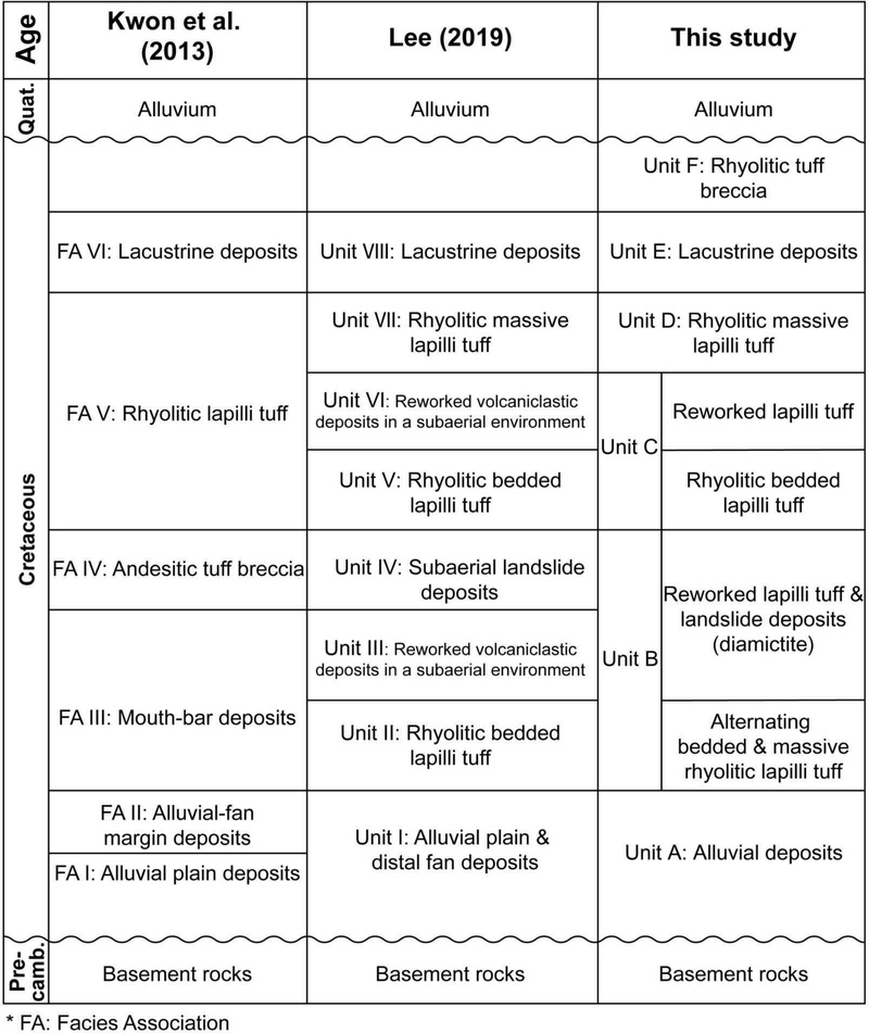
이번 연구에서는 선행 연구(Kwon et al., 2013; Lee, 2019)에서 밝혀진 충전물의 암상조합과 분류 체계를 바탕으로 하고 분지 전역에 걸쳐 추적되는 화산쇄설층을 건층(key bed)으로 활용하여 탄도분지 충전물을 6개의 퇴적단위(A-F)로 재구성하였다(표 1; 그림 2). 새로이 제시되는 퇴적단위는 주요 화산 사건을 기준으로 전후의 퇴적 사건을 구분하는 시간층서적 의미가 명확해 분지의 구조 진화를 시·공간적으로 해석하기 위한 시간 틀을 제공할 것이다.

Comparison of stratigraphic classifications of the Cretaceous Tando Basin fills by Kwon et al. (2013), Lee (2019), and this study.

(a-c) Detailed geological map of the Tando Basin in Ansan-si and Hwaseong-si. (d, e) Representative cross-sections of the basin.
퇴적단위 A, B, C는 분지 서편 해안을 따라 연속적으로 노출되며, 건층인 화산쇄설층(퇴적단위 B와 C 하부의 응회암층)이 측방으로 뚜렷하게 추적·관찰된다(그림 2). 가장 하부의 퇴적단위 A는 Kwon et al. (2013)의 충적 평원과 선상지 말단부 퇴적층인 상조합 I과 II에 해당되는 단위(표 1)로 최대 70 m의 두께로 노출되며, 대부분 비화산 기원의 쇄설성 퇴적암인 괴상 역암, 곡사층리 역암, 수평층리 역암, 괴상 사암, 곡사층리 사암, 수평층리 사암, 괴상 이암 등으로 구성된다(그림 3a; Lee, 2019). 한편, 분지의 북서부 불도에는 이 퇴적단위 연장부에 국지적으로 약 2 m 두께의 괴상 응회질 각력암이 관찰된다(그림 3b). 수십 cm ~ 수십 m 두께를 가지는 자색 이암은 충적평원에서 퇴적되었으며(Lee, 2019), 협재된 다양한 역암과 사암은 선상지 말단부에 발달한 조립질 퇴적물이 홍수기에 전진 퇴적하여 생성된 것으로 해석되었다(Kwon et al., 2013). 한편, 분지 북서부의 화산각력암은 분지 형성 초기에 발생한 국지적인 소규모 화산활동의 산물로 해석된다.

Outcrop photographs showing the major features of the depositional units in the Tando Basin. (a) Outcrop of Unit A showing massive conglomerate and cross-stratified sandstone cutting into massive purple mudstone, interpreted as distal alluvial fan and alluvial plain deposits. (b) Locally observed massive tuff breccia (~2 m thick) within Unit A in the Buldo area, indicating small-scale volcanic activity during the early stage of basin formation. (c) Well-bedded rhyolitic tuff of Unit C overlying the diamictite of Unit B. (d) Massive, reddish rhyolitic lapilli tuff of Unit D. (e) Rhyolitic tuff breccia of Unit F overlying the poorly sorted, matrix-supported conglomerate at the top of Unit E. (f) Close-up view of the rhyolitic tuff breccia of Unit F, showing poorly sorted clasts up to 50 cm in diameter.
약 15 m의 두께를 가지는 퇴적단위 B는 Lee (2019)의 퇴적단위 II, III, IV에 각각 해당되는 유문암질 화산력 응회암, 재동된 상부의 퇴적암, 그리고 사태성 다이아믹타이트로 구성된다(표 1). 하부의 유문암질 응회암은 층상과 괴상의 유문암질 화산력 응회암이 교호하며 각진 기반암 암편과 석영, 장석의 결정편 입자들로 주로 구성된다. 상부의 퇴적암은 주로 화산암편을 포함하는 분급이 불량한 자색 및 회색의 조립질 사암으로 이루어진 최대 6 m 두께의 재동층과 그 상위에 거력을 포함하고 분급이 불량한 최대 7 m 두께의 사태성 다이아믹타이트(그림 3c)로 구성된다. 최대 11 m의 두께를 가지는 퇴적단위 C는 Lee (2019)의 퇴적단위 V와 VI에 해당하는 하부의 층상 유문암질 응회암과 상부의 재동된 화산쇄설퇴적층으로 구성된다(표 1). 이 하부의 1차 화산 분출물과 상부의 재동된 쇄설물은 하나의 연속적인 화산-퇴적 작용을 지시하므로, 구조적 진화 단계상 단일 퇴적단위로 통합하였다. 최대 8 m 두께의 유문암질 응회암은 하부에서 화산회층과 화산력층이 교호하며 뚜렷한 층리가 발달하나(그림 3c) 상부로 갈수록 층리가 희미해지며, 주로 2 mm 이상의 유문암편과 석영, 장석의 광물편으로 구성된다. 그 상부는 하부의 응회암이 하천 환경에서 재동되어 퇴적된 자색 이암 내에 회색 조립질 사암과 역암이 협재된다(Lee, 2019). 역암의 역은 분급이 불량하고 대부분 아각형으로 최대 15 cm의 직경을 가진다. 분지 전역에서 가장 넓게 분포하는 퇴적단위 D는 두께가 100 m가 넘는 것으로 알려져 있으며(Kwon et al., 2013), Lee (2019)의 퇴적단위 VII인 유문암질 괴상 화산력응회암에 해당한다(표 1; 그림 2와 3d). 하부에서 약 1 m 두께의 층상 응회암이 협재되나, 전체적으로 괴상이며 두껍고 분급이 불량한 특징을 보여주고 있어 대규모 마그마성 분출활동에 의해 만들어진 화쇄류암으로 해석된다(Lee, 2019).
분지 중앙부에 분포하는 퇴적단위 E는 Kwon et al. (2013)과 Lee (2019)에서 제안된 호성 퇴적층으로 현생 조간대 퇴적물에 의해 대부분 덮여 있어 정확한 두께는 알 수 없으나 층서적으로 수백 m의 두께를 가질 것으로 추정된다(표 1; 그림 2; Kwon et al., 2013). 이 퇴적단위는 수 cm에서 수십 cm 두께의 회백색 내지 우백색을 띠는 세립질-조립질 사암과 이암의 교호층으로 주로 구성되며, 전반적으로 양호한 분급을 보인다. 최상부에는 각형 내지 아각형의 분급이 불량한 최대 2 cm 크기의 역으로 구성된 기질지지성 역암도 관찰된다(그림 3e). 이 퇴적단위에서 관찰되는 횡적 연장성이 좋은 사암은 저농도 저탁류에 의해 그리고 이와 수반되어 나타나는 괴상 이암은 저농도 저탁류 내에 부유하던 세립질 퇴적물이 낙하·침전된 결과물로 해석된다(Kwon et al., 2013).
탄도분지 내 딱섬에서 소규모로 노출되는 퇴적단위 F는 이번 연구에서 처음 보고되는 유문암질 응회각력암으로 퇴적단위 E의 최상부 하도 역암을 피복한다(그림 2와 3e). 이러한 층서적 상하 관계는 본 암석이 분지 발달 마지막 단계의 국지적인 화산 분출 산물임을 지시한다. 이 응회각력암은 야외에서 하부 퇴적단위의 응회암들에 비해 어두운 색을 띠나 기질과 각력이 모두 동일한 유문암질 응회암으로 구성되며 용결구조도 일부 관찰된다. 각력은 대부분 10 cm 이상의 직경을 가지며 최대 50 cm에 달한다(그림 3f).
4. 지질구조
4.1. 분지 경계단층
탄도분지 남동부 기반암 경계 부근에서 분지충전물의 층리면 주향이 시계반대방향으로 급격히 회전되며 최고 약 80°의 고각으로 경동되고 있어, 퇴적 후 단층운동에 의한 끌림습곡을 지시하고 있다(그림 4a, 8c). 이들 층리를 등적투영망에 투영하면 북동 방향의 축을 가지는 습곡이 도출된다(N64°E/38°NE; 그림 4b). 또한 이곳 남동부 경계부의 현생 조간대 바닥에서 기반암과 퇴적단위 A가 단층(N76°E/81°NW)으로 접촉하는 노두가 새롭게 관찰되었다(그림 4c). 단층경계 양편의 퇴적단위 A의 자색 이암과 기반암 모두에서 단층암이 발달하는데, 퇴적단위 A에서는 최대 5 cm의 단층비지와 약 6 m 폭의 단층각력암이 발달하는 반면, 기반암에는 상대적으로 얇은 약 1 m 폭의 단층각력암이 발달한다. 단층비지대 내에는 S자 형태의 끌림습곡이 발달하고 있어, 이 경계단층이 퇴적단위 A의 퇴적 이후에 좌수향 주향이동단층으로 운동하였음을 지시한다(그림 4d).

Characteristics of the southeastern border fault of the Tando Basin. (a) Detailed geological map showing a drag fold developed in the basin fills (Units A–C) near the border fault. (b) Equal-area stereonet of poles to bedding (N=9) from the basin fills shown in (a), indicating a fold with the axis (π-axis) plunging 38° toward N64°E. (c) Outcrop photograph of the border fault making a direct contact between basement rock and mudstone of Unit A. (d) S-shaped drags (red lines) within the gouge zone indicating a sinistral sense of shear of the fault.
4.2. 지층자세
탄도분지 충전물 총 131개 지점의 층리 자세가 수집되었으며, 이중 앞서 언급된 분지 남동 경계부와 소규모 단층 인근에서 국지적 변형을 받은 자세를 제외한 104개 자료를 분지 북서 경계부와 분지 내부의 것으로 구분하여 주향과 경사각의 변화를 분석하였다. 먼저 분지 북서 경계부에서 측정한 층리(N=18)는 인접한 추정 경계단층과 거의 평행하게 북동 방향의 주향을 가지며, 평균 21°로 남동쪽으로 경사진다(그림 2, 5a). 주목할만한 점은 이곳에서 노출되는 퇴적단위 A, B, C가 상부로 갈수록 경사각이 점진적으로 감소하는 특징이 뚜렷하게 관찰된다는 것이다(A: 23.8° → C: 17.6°)(그림 5b-d).

Analysis of bedding attitudes from the northwestern marginal part of the Tando Basin. (a) Stereonet (poles to bedding) and rose diagrams for the total measured strata (N=18). (b–d) Plots for each depositional unit, showing a progressive decrease in dip angle from Unit A (mean: 23.8°) to Unit B (mean: 19.0°) and Unit C (mean: 17.6°). All stereonets are lower-hemisphere, equal-area projections.
분지 내부의 총 86개 지점에서 획득된 층리 자세를 분석한 결과, 평균 주향은 N23°W이며 약 20°로 대부분 북동쪽으로 경사진다(그림 6a). 각 퇴적단위 별로 살펴보면, 퇴적단위 A, B, C는 북동 내지 동쪽으로 비교적 체계적인 경사 방향을 보여주나, 상위층인 퇴적단위 D와 E로 가면서 경사 방향의 분산이 커지며 반대 방향인 남서쪽으로 경사진 지층도 인지된다(그림 6b-f). 분지 동편 경계부 인근에서는 현생 퇴적물에 의해 노출이 제한적이나, 퇴적단위 E의 동쪽으로 하위 지층인 퇴적단위 D가 다시 노출되는 양상이 확인되며, 남서쪽으로 경사진 층리면은 분지의 동편에서 소규모로 노출되는 퇴적단위 D~F에서만 관찰된다(그림 2). 한편, 분지의 북서 경계부와 동일하게 분지 내부에서도 상위 퇴적단위로 갈수록 경사각이 점진적으로 얕아지는 양상이 잘 관찰된다(A: 28.0° → E: 14.2°). 이는 탄도분지 확장기 동안 분지 동쪽 혹은 중심부로 향하는 퇴적동시성 지괴 경동이 발생하였음을 지시한다(Son and Kim, 1994; Son et al., 2000, 2005; Cheon et al., 2012).

Analysis of bedding attitudes of the basin fill in western and central parts of the Tando Basin. (a) Stereonet (poles to bedding) and rose diagrams for the total measured strata (N=86). (b–f) Plots for each depositional unit. Note the progressive decrease in mean dip angle from Unit A (28.0°) to Unit E (14.2°). All plots are lower-hemisphere, equal-area projections.
4.3. 분지 내부 신장성 구조요소
분지 내부에는 지각 확장과 관련된 것으로 판단되는 퇴적동시성 정단층, 쇄설성 암맥 그리고 방해석 맥들이 도처에 관찰되었다. 주요한 퇴적동시성 정단층 노두들로 먼저 Site 1에서는 남-북 주향에 60-70° 동쪽 혹은 서쪽으로 경사진 공액상 정단층이 지구-지루(graben-horst) 구조를 형성한다(그림 7a, 7b). 이들은 단층 상반의 퇴적물 두께가 하반의 대비되는 것보다 두껍고 상부로 갈수록 변위가 감소하여 최상부 지층은 절단하지 못하는 전형적인 퇴적동시성 정단층의 특징을 보인다. Site 2에서는 남-북 내지 북북동 주향의 퇴적동시성 공액상 단층들이 퇴적단위 B의 자색 역암이 협재된 사질층을 절단하며(그림 7c, 7d), Site 3에서는 N24°W/42°NE의 자세를 가지는 퇴적단위 C를 절단하는 북동 방향의 전형적인 도미노 기하의 퇴적동시성 정단층들이 관찰된다(그림 8a, 8b). 한편, 분지 남동 경계부에 위치한 Site 4에서는 동-서 주향에 거의 수직에 가깝게 경사(83°)를 가진 지층을 절단하는 북동 주향의 좌수향과 북서 주향의 우수향의 공액상 단층 군집이 관찰된다(그림 8c, 8d). 이 단층들은 야외에서 주향이동성 변위를 보여주고 있으나, 단층면을 따라 단층암이 거의 발달하지 않고 사질층에서 뚜렷하게 관찰되는 지층 변위가 인접한 니질암에서 줄어들어 사라지고 있어 퇴적층이 완전히 고화되기 전에 공액상 정단층들로 만들어진 이후 지층이 거의 수직으로 경동되어 현재의 기하를 보이는 것으로 해석된다. 분지 서편에 위치한 Site 5에서는 N20°W/22°NE의 자세를 가지는 퇴적단위 A의 역암층을 절단하거나 수반된 습곡을 만드는 도미노 기하의 정단층들이 관찰된다(그림 8e, 8f).

Outcrop photograph showing syndepositional normal faults with their stereographic projection at Site 1 (See Fig. 2 for its locality). (a) Horst-and-graben structure observed in Units B and C. Upward decrease of stratal offsets and thicker layers in the hanging-walls (grabens) indicate syndepositional faulting. (b) Equal-area stereonet of the fault planes (N=11) before tilt correction. (c, d) Conjugate normal faults at Site 2 (Unit B) and their stereographic projection.

Outcrop photographs and streographic projections of syndepositional normal faults observed in the Tando Basin. (a, b) Domino-style normal faults at Site 3 (Unit C, bedding dip 42°), (c, d) conjugate normal faults at Site 4 (Unit B, bedding dip 83°), and (e, f) domino-style normal faults at Site 5 (Unit A, bedding dip 22°). Upward decrease and dying out of stratal offset and thicker bed in the hanging-wall indicate syndepositional faultings. Stereonets are equal-area, lower hemisphere projection before tilt correction. All the outcrop localities are indicated on Fig. 2.
관찰된 퇴적동시성 정단층들의 기하를 퇴적층의 경동 이전으로 복원하기 위해 층리 경사 보정을 수행하였다. 보정 효과는 층리 경사가 클수록 뚜렷하게 나타났다. 층리가 완만한 경사를 보이는 Site 1, 2, 5의 경우에는 변화가 미미한 반면, 급경사의 Site 3, 4에서는 단층 주향의 뚜렷한 회전이 관찰된다(그림 9a-e). Site 3에서는 단층 주향이 북동(보정 전)에서 북북동(보정 후)으로 회전되며, 보정 후 공액상 정단층 기하를 나타낸다. Site 4에서는 단층 주향이 북동에서 북북서로 회전하며, 역시 공액상 기하가 확인된다. 결과적으로, 보정된 퇴적동시성 정단층들의 주향은 대부분 북북서에서 북북동의 범위를 보인다(그림 9f).

Equal-area stereonets showing the attitudes of syndepositional normal faults before (white) and after (blue) tilt correction in the Tando Basin. (a-e) Plots for each site (Site 1-5) and (f) plot for the total fault population (N=45).
쇄설성 암맥은 퇴적단위 A와 D에서 총 7개가 관찰되었으며, 대부분 녹회색 조립질(0.5~2 mm) 모래 입자로 구성되나 일부는 아원형~아각형의 역을 포함한다. 야외에서 측정된 암맥들의 자세를 인근 층리면을 이용해 경사 보정하면 평균 북북동의 주향을 보인다(그림 10a). 분지 서편 해안가에서 퇴적단위 A의 자색 사암층을 관입하고 있는 남-북 주향의 쇄설성 암맥(그림 10b, 10c)은 최대 5 cm의 폭을 가지며 녹회색 조립질 사질암의 암상을 보인다. 분지 남동편 해안가에서 퇴적단위 D의 괴상 응회암을 관입하고 있는 북북동 주향의 쇄설성 암맥은 폭이 5 mm에서 5 cm까지로 변화되며 녹회색 조립질 모래 기질에 1.6 cm 직경의 기질지지성(matrix-supported) 아원형~아각형의 역을 포함한다(그림 10d). 이 쇄설성 암맥은 하부의 사암층에서 유래되었음을 알려주는 뿌리 구조가 관찰되어(그림 10e), 상부 퇴적물이 암석 내 균열을 따라 아래로 충전된 퇴적형 암맥(neptunian clastic dike)가 아니라 지진동 등에 의해 하부의 미고결 사질층에 내에 과압이 형성되어 상부로 주입된 주입형 암맥(injected clastic dike)으로 판단된다(Tuttle and Seeber, 1991; Munson et al., 1995; Cho et al., 2017).

Outcrop photographs and orientation data of clastic dikes in the Tando Basin. (a) Rose diagram showing the strikes of clastic dikes (N=7). (b, c) A N-S striking clastic dike intruding the purple mudstone of Unit A. (d) A NNE-striking clastic dike intruding the massive tuff of Unit D. (e) Root structure observed at the base of Unit D, indicating an injection-type clastic dike.
한편, 탄도분지 충전물 중 특히 퇴적단위 A에는 도처에 방해석 맥들이 관찰된다. 이번 연구에서는 총 194개의 방해석 맥의 자세(그림 11a)가 수집되었으며, 이중 89%에 해당하는 172개가 최하부 퇴적단위 A에서 측정되었다(그림 11b). 이들 방해석맥은 남-북과 북서 주향의 것들이 우세하며 대부분 60° 이상의 고각으로 발달한다. 두께는 수 mm에서 최대 약 2 cm, 연장은 최대 2.5 m 이상의 것도 관찰된다(그림 11c-e).

Outcrop photographs and orientation data of calcite veins in the Tando Basin. (a) Equal-area stereonet (poles to planes) and rose diagram for all measured calcite veins (N=194). (b) Stereonet plot and rose diagram for calcite veins observed in Unit A (N=172). Both datasets show dominant N-S and NW-SE strikes. (c-e) High-angle calcite veins with N-S to NW-SE strikes observed in Unit A. All stereonets are equal-area, lower-hemisphere projection.
5. 고응력장 복원
앞서 기술된 퇴적동시성 정단층군이 관찰된 5개 지점의 단층들을 대상으로 먼저 인근 층리를 이용하여 경사 보정을 한 이후, 단층면에서 관찰된 이동(slip) 자료와 공액상 단층군의 기하를 이용하여 고응력장 복원을 수행하였다(그림 12a). 단층의 이동 자료를 활용한 고응력 복원을 위해 Delvaux and Sperner (2003)의 Wintensor S/W를 활용하였으며, 지점에 따라 동-서(지점 1과 2), 서북서-동남동(지점 3과 5), 동북동-서남서(지점 4) 방향으로 거의 수평한 최소주응력축(σ3)들이 도출되었다. 응력지수 R'은 0.35~0.58의 범위를 나타내어 단층이 순수 인장(pure extensive, 0.25≤R'≤0.75) 환경에서 활동하였음을 지시한다[0≤R'≤1 (인장환경), 1≤R'≤2 (주향이동환경), 2≤R'≤3 (압축환경); Delvaux et al. (1997)]. 이와 함께 5개 지점 단층 이동 자료들은 모두 합치면 서북서-동남동 방향의 최소수평응력과 0.3의 R'이 도출된다. 한편, 공액상 단층면들이 이루는 기하를 이용해 구한 응력장에서는 거의 동-서 방향 세 개(지점 1, 2, 3)와 서북서-동남동 방향 1개 지점(지점 5) 그리고 동북동-서남서 방향 1개 지점(지점 4)의 최소수평응력이 구해졌다. 이와 함께 모든 지점의 단층 기하 자료를 합치면 거의 동-서 방향의 최소수평응력이 도출된다. 이상의 결과들을 종합하면, 탄도분지 충전물 내 퇴적동시성 정단층군은 서북서-동남동과 동북동-서남서 방향의 범위 내에서 평균 동-서 방향으로 작동된 최소주응력 하에서 발생한 지각변형의 결과로 해석된다(그림 12a).

(b) Structural map of the Tando Basin. (a) Paleostress fields determined from the fault slip and geometry data. The left and right stereonets for each site show the results of paleostress inversion from fault slip and geometry data, respectively. Calculated principal stress axes σ1, σ2 and σ3 are indicated with a black circle, triangle, and square, respectively. All stereonets are lower-hemisphere, equal-area projections. Rose diagrams showing the strike distributions and causative minimum horizontal stresses (divergent arrows) of (c) calcite veins and (d) clastic dikes.
일반적으로 분지 충전물이 완전히 고화되지 않은 상태에서 주변에 강한 지진동이 발생하면 지하수에 포화되어 있던 사질층이 액상화로 과압되어, 상부의 상대적으로 응집력이 높은 지층을 파쇄하고 유입되어 주입형 쇄설성 암맥이 만들어진다(Tuttle and Seeber, 1991; Munson et al., 1995; Cho et al., 2017). 이때 주입되는 퇴적물의 통로가 되는 인장단열은 당시 최소주응력(σ₃)에 수직한 방향으로 배열되고자 하기 때문에 주입형 쇄설성 암맥의 배열 방향은 당시의 최소수평응력에 관한 정보를 제공할 수 있다(Cho et al., 2017). 탄도분지 충전물에서 관찰되는 쇄설성 암맥은 경사 보정 이후 북북동-남남서 방향을 체계적으로 보이고 있어, 서북서-동남동 방향의 최소수평응력 하에서 형성되었음을 지시한다(그림 12d). 또한, 이들 암맥이 서로 다른 층준(퇴적단위 A와 D)에서 산출되는 것은 분지 확장기 동안 다수의 지진동에 의해 반복적으로 형성된 결과로 해석된다. 이와 함께, 탄도분지 내 방해석 맥들이 남-북 내지 북서 방향의 체계적인 방향성을 가진다는 사실은 열수활동이 활발하던 시기에 평균 동북동-서남서 방향의 최소수평응력이 작동하였음을 시사한다(그림 12c).
6. 토 의
6.1. 분지의 기하
충전물의 층리 자세는 분지 북서와 남동 경계부 그리고 내부에서 공간적으로 뚜렷한 차이를 보인다. 먼저, 북서 경계부에서는 북동 방향의 추정 경계단층과 거의 평행하게 주향이 배열되고 북서에서 남동쪽으로 퇴적단위 A, B, C, D가 순차적으로 노출된다(그림 2). 기존 연구에서는 이러한 퇴적층의 자세와 분포를 단층운동으로 형성된 분지 내 저지대로 퇴적물이 전진·집적된 결과로 해석하였다(Jeong et al., 2008; Kwon et al., 2011; Lee, 2019). 이번 연구에서 지층별 경사분석을 한 결과, 북서 경계부에서 퇴적단위 A, B, C의 경사는 상부로 갈수록 감소하는 특징(A: 23.8° → B: 19.0° → C: 17.6°; 그림 5)을 보여준다.
분지 남동 경계부의 층리는 경계단층 인접부에서 북동쪽으로 향하던 경사가 빠르게 시계반대방향으로 회전되어 북서쪽의 분지 내부를 향해 경사진다(그림 2, 4). 그러나 이곳 층리의 경사는 20° 내외의 저경사를 가지는 북서 경계부와는 달리 최대 80° 이상의 고경사를 가진다(그림 8e). 또한 경계단층을 따라 분지충전물인 적색 이암 내에 단층비지대와 함께 약 6 m 폭의 각력암대가 만들어져 있어, 이곳 남동 경계부에서는 충전물의 퇴적·고화 이후에도 좌수향 주향이동단층운동이 지속되었으며 이로 인한 끌림습곡이 중첩되어 북동부에 비해 지층 경동이 크게 발생한 것으로 판단된다(그림 4). 이러한 후기 변형과 함께 노두가 매우 제한적으로 노출되고 있어, 이곳 남동 경계부에서 초기 퇴적동시성 지각 변형과 분지 형태를 알려주는 구조적 증거를 찾는 데는 한계가 있다.
분지 내부 충전물 분포를 살펴보면(그림 2), 서쪽 해안가에서부터 동쪽으로 가면서 퇴적단위 A부터 F까지 모든 퇴적단위가 차례로 노출되다가 동편에서 퇴적단위 E와 D 순서로 하부층이 반복 출현하는 양상이다. 퇴적단위 D보다 동편의 분지 경계부에는 하위 퇴적단위인 C, B, A가 차례로 분포할 가능성이 있으나 현생 조간대 퇴적물로 피복되어 노두가 노출되지 않아 확인할 수 없다. 분지 서편에 분포하는 퇴적단위 A, B, C는 남-북 내지 북서 주향을 가지며 일관되게 동쪽 내지 북동쪽으로 경사지는 반면, 보다 동편의 퇴적단위 D와 E는 북서 주향과 북동 방향 경사가 우세하나 동쪽 기반암에 근접하면 남서로 경사 방향이 바뀌고 있어 북북서-남남동 내지 북서-남동 방향의 수평축을 가진 완만한 향사 구조를 형성한다(그림 6, 12). 한편, 분지 내부의 충전물도 북서 경계부 것과 유사하게 상부 퇴적단위로 갈수록 층리 경사가 점진적으로 감소하는 경향(A: 28.0° → E: 14.2°)이 뚜렷해 퇴적과 동시에 분지 중심부를 향한 지속적인 지괴 경동이 발생하였으며(Son and Kim, 1994; Son et al., 2000, 2005; Cheon et al., 2012), 분지 중심부의 침강량이 보다 커 두꺼운 퇴적물이 축적되었음을 시사한다(Christie-Blick and Biddle, 1985; Nilsen and Sylvester, 1995; Cunningham and Mann, 2007). 따라서 탄도분지는 북북서-남남동 방향의 축을 따라 신장되고 퇴적과 동시에 중심부가 지속적으로 침강한 곡분(trough)의 기하를 가지는 것으로 판단된다(그림 13a-c). 이번 연구에서 '곡분'은 분지의 장축을 따라 더 깊은 차별적인 함몰이 발생하여 양측 경계부에서 관찰되는 충전물의 층리가 분지 중앙 축을 향해 경사하는 여물통 모양의 구조를 지칭한다. 탄도분지 경계에 대한 직접적인 정보는 제한적이나 기반암과 충전물의 분포를 볼 때 분지의 평면적인 형태는 평행사변형 기하를 보이는데(그림 2와 12b), 이는 앞서 지질학적 배경에서 언급한 바와 같이, 주향이동단층운동으로 만들어지는 당겨열림분지의 형태적 특징에 부합한다(그림 13e). 상대적으로 작은 규모에 비해 탄도분지의 퇴적층 두께는 상당히 두꺼운 것으로 추정되고 있는데(>1.5 km; Kwon et al., 2013), 이는 당겨열림분지에서 나타나는 빠른 구조적 침강을 반영하는 것으로 해석된다(Christie-Blick and Biddle, 1985; Pitman and Andrews, 1985). 이러한 분지 전반의 체계적인 경동과 빠른 침강에 따른 두꺼운 퇴적은 탄도분지의 북서와 남동 경계단층이 주향이동단층으로 짝을 이루어 분지 확장을 주도하였음을 시사한다.

(a-c) Schematic block diagrams showing the progressive evolution of the Tando Basin. Divergent blue arrows indicate the dominant E-W extension during the basin formation. Note that the volcanoes depicted in (a) and (b) do not indicate the exact geographic locations of craters, but are conceptually illustrated to represent stratigraphic volcanic events and material influx based on the depositional model of Lee (2019). (d) Stress field associated with NE-striking sinistral strike-slip faulting and (e) typical parallelogram-shaped geometry of pull-apart basin formed between the sinistral faults.
6.2. 분지 확장형식과 진화
탄도분지 내부에는 동-서 방향의 지각 신장을 지시하는 퇴적동시성 구조들이 발달한다. 경사 보정된 퇴적동시성 정단층들은 북북서~북북동 주향으로 발달하며(그림 9), 쇄설성 암맥들은 평균 북북동 주향을 보인다(그림 10). 남-북 및 북서-남동 주향의 방해석 맥들은 최하부 퇴적단위 A에 집중되나 상위 지층에서도 일부 관찰된다(그림 11과 12c). 이는 방해석 맥들이 분지 형성이 완전히 종료된 이후의 단일 사건이라기보다는, 분지가 확장되는 동안 층서적으로 반복된 화산활동(퇴적단위 B, C, D, F)에 동반되어 심부 열수가 여러 차례에 걸쳐 주입된 결과로 해석된다. 열수 주입이 퇴적단위 A에 집중된 것은 분지 기저를 이루는 이 지층이 열수가 상승하는 일차적인 통로 역할을 하였음을 지시한다. 단층들의 기하와 운동학적 자료를 이용하여 고응력장을 복원한 결과, 최소수평응력(σHmin)은 일관되게 서북서-동남동에서 동북동-서남서 사이의 방향을 지시한다(그림 12a). 이러한 북북동, 남-북 내지 북북서 주향의 인장성 구조들은 분지를 경계하는 북동 주향의 단층들과 약 30°-70°로 사교하는 배열을 보이고 있어, 횡인장(transtension) 환경의 당겨열림분지에서 주변위대(principal displacement zone)와 사교하는 부차 인장구조의 방향성에 부합한다(Willcox et al., 1973; Davis and Reynolds, 1996; Wu et al., 2009; Davis et al., 2012; Nabavi et al., 2018). 따라서 탄도분지는 북동 주향의 좌수향 경계단층의 주향이동운동에 수반된 횡인장 환경에서 동-서 방향 인장응력이 우세하게 작동되어 만들어진 당겨열림분지로 해석된다.
한편, 충전물의 자세를 분석하면 분지는 북북서-남남동 방향의 축을 중심으로 신장된 곡분의 기하를 가지고 있어, 분지 확장 축이 동-서 인장 방향에 완전히 수직하지 않으며 경계단층과 70~80°의 고각도로 사교하는 기하를 가진다(그림 12b과 13e). 이러한 분지 장축 방향을 설명하기 위해 다음의 두 가지 형성 가능성을 고려할 수 있다. 첫째, 분지 장축이 분지 확장 시 두 경계단층 사이에 만들어진 연결부의 기하를 직접 반영할 가능성이다. 당겨열림분지에서 분지 장축은 양편 경계단층 사이의 계단부 또는 굴곡부의 기하와 흔히 일치한다(Mann et al., 1983; Cunningham and Mann, 2007). 탄도분지의 경우, 북동 주향의 경계단층들이 주변위대로 활동할 때 이를 연결하는 구조가 북북서-남남동 방향으로 만들어지며 분지의 확장을 주도한 것으로 해석될 수 있다. 둘째, 백악기 이전부터 북북서 주향의 기존 약대가 주변위대 사이에 이미 존재하였으며 당겨열림 과정에서 이 약대가 재활되며 분지의 기하와 확장에 영향을 미쳤을 가능성이다. 이러한 해석은 탄도분지가 비슷한 시기에 형성된 인근의 남양분지, 철원분지 및 천수만분지와 구별되는 구조적 진화사를 가지는 이유를 잘 설명해 준다. 남-북 내지 북북동 주향의 우수향 단층 운동에 지배된 남양 및 철원분지(Kee et al., 2006, 2008)나, 초기 좌수향 당겨열림 이후 동-서 방향의 단층 운동에 의해 불규칙한 쐐기형(wedge shape)으로 복잡하게 변형된 천수만분지(Kee et al., 2011) 등 타 분지들의 진화사와는 달리, 탄도분지는 북동 주향의 좌수향 경계단층 운동과 더불어 북북서 방향의 단층 연결부 기하 또는 기존 약대가 복합적으로 영향을 미치며 동-서 방향의 인장력이 국지적으로 집중된 것으로 해석된다.
이번 연구에서 분석한 지질구조요소들에 기반하여 탄도분지의 진화 과정을 시간적으로 해석해 보면, 분지 초기에 북동 주향 경계단층들의 좌수향 단층운동에 수반된 당겨열림 공간이 처음 만들어지고, 동시에 이들 경계단층 사이에서 인장응력이 집중됨에 따라 남-북 내지 북북동 주향의 정단층들이 분지 형성을 주도하는 열개 단계가 진행되었다. 이 저지로 선상지 퇴적물과 충적평원의 퇴적물인 퇴적단위 A가 채워지기 시작하였다(그림 13a). 이후 본격적인 확장 단계에서는 동-서 방향 인장 응력 하에서 남-북 내지 북북동 주향의 공액상 정단층과 쇄설성 암맥들이 활발히 만들어졌으며, 분지 인근에서 반복적으로 일어난 화산활동으로 공급된 화산쇄설물이 분지 내에 축적되면서 퇴적단위 B, C, D가 형성되었다(그림 13b). 후기에는 화산활동이 종료되고 호성 퇴적물인 퇴적단위 E가 분지 내부에 광범위하게 쌓였으며, 최종적으로 분지 중심부에 소규모 화산 분출에 의한 퇴적단위 F가 퇴적되었다.
이상의 결과를 종합하면, 탄도분지는 초기 정단층 활동이 우세한 열개 과정을 거쳐 최종적으로 북동-남서 방향의 좌수향 경계단층들의 주향이동운동에 수반된 횡인장 환경에서 형성된 소규모 당겨열림분지로 진화한 것으로 해석된다(그림 13d, 13e). 이러한 분지확장 형식은 백악기 한반도에 발달한 다른 대부분의 소규모 당겨열림분지들과 매우 흡사하다(Lee and Paik, 1990; Kim et al., 1994; Choi, 1996; Lee and Kim, 2003; Hwang and Choi, 2013). 다만 탄도분지의 경우 분지 내부 변형 기록이 동–서 성분의 인장을 뚜렷하게 지시하며 분지 장축이 북북서–남남동 방향으로 배열되는 특징을 보인다. 이러한 차이는 당겨열림이 발생하는 주향이동단층 사이의 굴곡부 또는 계단부에서 주변위대를 이어주는 연결부의 기하와 운동의 차이에 기인할 가능성이 높다.
7. 결 론
본 연구는 경기도 화성시와 안산시 일원의 백악기 탄도분지에 대한 상세한 야외지질조사를 수행하여 분지 경계를 추적하고, 충전물의 구조요소들의 기하와 운동학적 특성을 분석하였다. 이를 통해 탄도분지의 기하와 확장형식을 해석하였으며 주요 결론은 다음과 같다.
1) 탄도분지는 경기도 안산시-화성시 일원에 위치하며, 북동-남서 방향으로 약 2.6 km의 폭과 북서-남동 방향으로 약 3.4 km의 길이를 가진다. 분지 남동편에서는 북동 주향(N76°E)의 경계단층이 노두로 확인된다. 분지충전물의 자세 분석 결과, 분지는 북북서-남남동 방향의 축을 가지는 곡분의 기하를 보이며, 이는 주향이동분지에서 특징적으로 나타나는 평행사변형 기하와 일치한다.
2) 시간층서적 해석을 위해 주요 화산쇄설층을 건층(key bed)으로 활용하여 충전물을 총 6개의 퇴적단위(A-F)로 구분하였다. 기저를 이루는 퇴적단위 A는 자색 이암, 사암, 역암으로 구성된 충적평원과 선상지 쇄설성 퇴적층이며(두께 수십 m 이상), 국지적으로 응회질각력암이 협재한다. 그 상위의 퇴적단위 B는 하부의 유문암질 화산력응회암과 상부의 재동 퇴적층 및 사태 퇴적물(다이아믹타이트, 두께 ~15 m)로 그리고 퇴적단위 C는 층상 유문암질 응회암과 재동 퇴적층으로 이루어진다(두께 ~8 m). 퇴적단위 D는 괴상 유문암질 화산력응회암이 우세하며(두께 >100 m), 그 위를 호성 환경의 퇴적단위 E(사암-이암 교호층 및 하도 역암, 두께 수백 m)가 덮는다. 최상부 퇴적단위 F는 화산암괴를 포함하는 유문암질 응회각력암으로 자기각력화 및 용결 구조가 관찰되어 분지 발달 마지막 단계의 국지적 화산 분출을 지시한다.
3) 충전물의 층리 자세는 분지 경계부와 내부에서 체계적인 차이를 보인다. 분지 경계부에서는 경계단층과 아평행하게 층리가 배열되고 분지 내부로 경사지며, 특히 남동 경계에서는 후기 좌수향 주향이동단층운동을 지시하는 고각 경동 지층과 끌림습곡이 발달한다. 분지 내부 층리는 전체적으로 북북서 주향을 가지며 북북서-남남동 축의 완만한 향사 구조를 형성한다. 상부로 갈수록 층리 경사각이 점진적으로 감소하는 경향은 분지 경계부(23.8° → 17.6°)와 내부 전반(28.0° → 14.2°)에 걸쳐 공통적으로 관찰되어, 퇴적과 동시에 분지 내부가 지속적으로 침강 및 경동되었음을 지시한다.
4) 분지 내부에는 북북서 내지 북북동 주향의 퇴적동시성 정단층과 북북동 주향의 쇄설성 암맥이 발달하며, 최하부 퇴적단위 A에 집중된 방해석 맥은 북북서 방향으로 발달한다. 고응력장 복원 결과, 서북서-동남동에서 동북동-서남서 사이의 최소수평응력(σHmin)이 일관되게 도출되어, 북동 방향의 분지 경계단층의 좌수향 주향이동단층운동에 의해 분지 내부에 동-서 방향 인장력이 작용하였음을 지시한다. 5) 이상의 연구결과는 탄도분지가 북동-남서 주향 경계단층의 좌수향 주향이동운동에 수반된 횡인장 환경에서 확장된 당겨열림분지임을 지시한다. 다만 탄도분지의 동–서 인장구조와 북북서-남남동의 분지 장축은 기존에 알려진 한반도의 백악기 소규모 당겨열림분지들의 것과 방향성에서 다소 차이를 보이는데, 이는 당겨열림이 발생하는 주변위대 사이 연결부의 기하 차이에 기인할 가능성이 높다.
Acknowledgments
이 논문은 행정안전부 지진 위험분석 및 관리기술개발사업[(2022-MOIS62-001(RS-2022-ND640011)]과 지진안전분야 전문인력 양성사업의 지원을 받아 수행된 연구입니다.
References
-
Aydin, A. and Nur, A., 1982, Evolution of pull-apart basins and their scale independence. Tectonics, 1, 91-105.
[https://doi.org/10.1029/TC001i001p00091]

-
Cheon, Y., Son, M., Song, C.W., Kim, J.-S. and Sohn, Y.K., 2012, Geometry and kinematics of the Ocheon Fault System along the boundary between the Miocene Pohang and Janggi basins, SE Korea, and its tectonic implications. Geosciences Journal, 16, 253-273.
[https://doi.org/10.1007/s12303-012-0029-0]
-
Cho, H., Son, M., Sohn, Y.K. and Park, M.E., 2017, Magnetic fabric (anisotropy of magnetic susceptibility) constraints on emplacement mechanism of clastic dikes. Journal of Geophysical Research: Solid Earth, 122, 3306-3333.
[https://doi.org/10.1002/2016JB013583]
- Choi, Y.S., 1996, Structural evolution of the Cretaceous Eumseong Basin, Korea. Ph.D. thesis, Seoul National University, Seoul, 159 p (in Korean with English abstract).
- Chough, S.K., 2013, Geology and sedimentology of the Korean Peninsula. Newnes, Amsterdam, 363 p.
-
Chough, S.K. and Sohn, Y.K., 2010, Tectonic and sedimentary evolution of a Cretaceous continental arc-backarc system in the Korean Peninsula: New view. Earth-Science Reviews, 101, 225-249.
[https://doi.org/10.1016/j.earscirev.2010.05.004]
-
Chough, S.K., Kwon, S.T., Ree, J.H. and Choi, D.K., 2000, Tectonic and sedimentary evolution of the Korean Peninsula: A review and new view. Earth-Science Reviews, 52, 175-235.
[https://doi.org/10.1016/S0012-8252(00)00029-5]
-
Christie-Blick, N. and Biddle, K.T., 1985, Deformation and basin formation along strike-slip faults. In: Biddle, K.T. and Christie-Blick, N. (eds.), Strike-Slip Deformation, Basin Formation, and Sedimentation. SEPM Special Publication, 37, 1-34.
[https://doi.org/10.2110/pec.85.37.0001]
-
Crowell, J.C., 1974, Origin of late Cenozoic basins in southern California. In: Dickinson, W.R. (ed.), Tectonics and Sedimentation. SEPM Special Publication, 22, 190-204.
[https://doi.org/10.2110/pec.74.22.0190]
-
Cunningham, W.D. and Mann, P., 2007, Tectonics of strike-slip restraining and releasing bends. In: Cunningham, W.D. and Mann, P. (eds.), Tectonics of Strike-Slip Restraining and Releasing Bends. Geological Society, London, Special Publications, 290, 1-12.
[https://doi.org/10.1144/SP290.1]
- Davis, G.H. and Reynolds, S.J., 1996, Structural Geology of Rocks and Regions (2nd ed.). John Wiley & Sons, 776 p.
- Davis, G.H., Reynolds, S.J. and Kluth, C.F., 2012, Structural Geology of Rocks and Regions (3rd ed.). John Wiley & Sons, 839 p.
-
Delvaux, D., Moeys, R., Stapel, G., Petit, C., Levi, K., Miroshnichenko, A., Ruzhich, V. and Sankov, V., 1997, Paleostress reconstruction and geodynamics of the Baikal region, Central Asia, Part 2: Cenozoic rifting. Tectonophysics, 282, 1-38.
[https://doi.org/10.1016/S0040-1951(97)00210-2]
-
Delvaux, D. and Sperner, B., 2003, New aspects of tectonic stress inversion with reference to the TENSOR program. In: Nieuwland, D.A. (ed.), New Insights into Structural Interpretation and Modelling. Geological Society, London, Special Publications, 212, 75-100.
[https://doi.org/10.1144/GSL.SP.2003.212.01.06]
-
Engebretson, D.C., Cox, A. and Gordon, R.G., 1985, Relative motions between oceanic and continental plates in the Pacific Basin. Geological Society of America Special Papers, 206, 1-49.
[https://doi.org/10.1130/SPE206-p1]
-
Hempton, M.R. and Dunne, A., 1984, Sedimentation in pull-apart basins: Active examples in eastern Turkey. Journal of Geology, 92, 513-530.
[https://doi.org/10.1086/628889]
- Hwang, J.H. and Choi, P.-Y., 2013, Tectonic deformation and paleostress reconstruction based on fault-slip data in the Yongdong Basin. Journal of the Geological Society of Korea, 49, 363-371 (in Korean with English abstract).
-
Jeong, J.O., Kwon, C.W. and Sohn, Y.K., 2008, Lithofacies and architecture of a basinwide tuff unit in the Miocene Eoil Basin, SE Korea: Modes of pyroclastic sedimentation, changes in eruption style, and implications for basin configuration. Geological Society of America Bulletin, 120, 1263-1279.
[https://doi.org/10.1130/B26077.1]
-
Kee, W.S., Kim, B.C. and Lee, Y.N., 2006, Sedimentary environments and structural evolution of the Cretaceous Namyang Basin, Korea. Journal of the Geological Society of Korea, 42, 329-351 (in Korean with English abstract).
[https://doi.org/10.14770/jgsk.2006.42.3.329]
- Kee, W.S., Koh, H.J., Kim, S.W., Kim, B.C., Kim, Y.B., Kim, Y.H., Kim, H.C., Park, S.I., Song, K.Y., Lee, S.R., Lee, Y.S., Lee, Y.N., Lee, H.J., Cho, D.L., Choi, B.Y., Choi, S.J., Chwae, W.C. and Hwang, J.H., 2011, Tectonic evolution of upper crustal units in the mid-western part of the Korean Peninsula. Korea Institute of Geoscience and Mineral Resources, 255 p (in Korean with English abstract).
- Kee, W.S., Koh, H.J., Kim, S.W., Kim, B.C., Kim, Y.B., Kim, Y.H., Kim, H.C., Park, S.I., Song, K.Y., Lee, S.R., Lee, Y.S., Lee, Y.N., Lee, H.J., Jeon, H.Y., Cho, D.L., Choi, B.Y., Choi, S.J., Chwae, W.C. and Hwang, J.H., 2010, Tectonic evolution of upper crustal units in the mid-western part of the Korean Peninsula. Korea Institute of Geoscience and Mineral Resources, 242 p (in Korean with English abstract).
- Kee, W.S., Rhim, S.-B., Kim, H.-C., Hwang, S.-K., Kim, B.-C., Song, K.-Y., and Kim, Y.-H., 2008, Geological report of the Yeoncheon sheet. Korea Institute of Geoscience and Mineral Resources, 83 p.
- Kim, H., 2018, Tectonic Structure Map of the Dangjin-Daesan Area. Korea Institute of Geoscience and Mineral Resources (KIGAM), KR-M-10-003-2018, 1 sheet.
-
Kim, J.H., Lee, J.Y. and Kee, W.S., 1994, Structural evolution of the Cretaceous Puyeo Basin, Korea. Journal of the Geological Society of Korea, 30, 182-192 (in Korean with English abstract).
[https://doi.org/10.14770/jgsk.1994.30.2.182]
-
Kim, S.B., Kim, Y.G., Jo, H.R., Jeong, K.S. and Chough, S.K., 2009, Depositional facies, architecture and environments of the Sihwa Formation (Lower Cretaceous), mid-west Korea with special reference to dinosaur eggs. Cretaceous Research, 30, 100-126.
[https://doi.org/10.1016/j.cretres.2008.05.016]
- Kwon, C.W., Choi, S.J., Lee, Y.N., Chwae, U.C., Kee, W.S. and Kim, B.C., 2013, Basin geometry, depositional environment, dinosaur bone, and basin evolution in the Cretaceous Tando Basin, mid-west Korea. Journal of the Geological Society of Korea, 49, 137-152 (in Korean with English abstract).
-
Kwon, C.W., Jeong, J.O. and Sohn, Y.K., 2011, Sedimentary records of rift to pull-apart tectonics in the Miocene Eoil Basin, SE Korea. Sedimentary Geology, 236, 256-271.
[https://doi.org/10.1016/j.sedgeo.2011.01.011]
-
Lee, B.J. and Kim, B.C., 2003, Geology and structural development of the Cretaceous Gongju Basin, Korea. Journal of the Geological Society of Korea, 39, 161-170 (in Korean with English abstract).
[https://doi.org/10.14770/jgsk.2003.39.2.161]
- Lee, B.J., Lee, S.R. and Cho, D.L., 1999, Geological report of the Daebudo sheet (1:50,000). Korea Institute of Geoscience and Mineral Resources, 31 p (in Korean with English abstract).
-
Lee, D.W., 1999, Strike-slip fault tectonics and basin formation during the Cretaceous in the Korean Peninsula. Island Arc, 8, 218-231.
[https://doi.org/10.1046/j.1440-1738.1999.00233.x]
-
Lee, D.W. and Paik, K.H., 1990, Evolution of strike-slip fault-controlled Cretaceous Yongdong Basin, South Korea: Signs of strike-slip tectonics during infilling. Journal of the Geological Society of Korea, 26, 257-276.
[https://doi.org/10.14770/jgsk.1990.26.3.257]
- Lee, J.H., 2019, Evolution of the Cretaceous Tando Basin: Linked tectonic and volcanic activities and sedimentation. M.S. thesis, Gyeongsang National University, Jinju, 80 p (in Korean with English abstract).
-
Lithgow-Bertelloni, C. and Richards, M.A., 1998, The dynamics of Cenozoic and Mesozoic plate motions. Reviews of Geophysics, 36, 27-78.
[https://doi.org/10.1029/97RG02282]
-
Mann, P., Hempton, M.R., Bradley, D.C. and Burke, K., 1983, Development of pull-apart basins. Journal of Geology, 91, 529-554.
[https://doi.org/10.1086/628803]
-
Maruyama, S., Isozaki, Y., Kimura, G. and Terabayashi, M., 1997, Paleogeographic maps of the Japanese Islands: Plate tectonic synthesis from 750 Ma to the present. The Island Arc, 6, 121-142.
[https://doi.org/10.1111/j.1440-1738.1997.tb00043.x]
-
Munson, P.J., Munson, C.A. and Pond, E.C., 1995, Paleoliquefaction evidence for a strong Holocene earthquake in south-central Indiana. Geology, 23, 325-328.
[https://doi.org/10.1130/0091-7613(1995)023<0325:PEFASH>2.3.CO;2]
-
Nabavi, S.T., Alavi, S.A. and Jabarabai, H.J., 2018, The Dinevar transtensional pull-apart basin, NW Zagros Mountains, Iran: A geological study and comparison to 2D finite element elastic models. International Journal of Earth Sciences, 108, 329-346.
[https://doi.org/10.1007/s00531-018-1656-0]
- Nilsen, T.H. and Sylvester, A.G., 1995, Strike-slip basins. In: Busby, C.J. and Ingersoll, R.V. (eds.), Tectonics of Sedimentary Basins. Blackwell Science, Cambridge, USA, 425-457.
- Park, S.D., Chung, G.S., Jeong, J.G., Kim, W.S., Lee, D.W. and Song, M.Y., 2000, Structure and physical property of the crust of mid-west Korea: Analysis of sedimentary basins in the Namyang and Tando areas, Gyeonggi Province, Korea. Journal of Korean Earth Science Society, 21, 563-582 (in Korean with English abstract).
-
Pitman, W.C., III and Andrews, J.A., 1985, Subsidence and thermal history of small pull-apart basins. In: Biddle, K.T. and Christie-Blick, N. (eds.), Strike-Slip Deformation, Basin Formation, and Sedimentation. SEPM Special Publication 37, 45-49.
[https://doi.org/10.2110/pec.85.37.0045]
- Ryang, W.-H., 2013, Characteristics of strike-slip basin formation and sedimentary fills and the Cretaceous small basins of the Korean Peninsula. Journal of the Geological Society of Korea, 49, 31-45 (in Korean with English abstract).
- Son, M. and Kim, I.-S., 1994, Geological structures and evolution of the Tertiary Chongja Basin, southeastern margin of the Korean Peninsula. Economic and Environmental Geology, 27, 65-80 (in Korean with English abstract).
-
Son, M., Kim, I.-S. and Sohn, Y.K., 2005, Evolution of the Miocene Waup Basin, SE Korea, in response to dextral shear along the southwestern margin of the East Sea (Sea of Japan). Journal of Asian Earth Sciences, 25, 529-544.
[https://doi.org/10.1016/j.jseaes.2004.06.003]
-
Son, M., Seo, H.J. and Kim, I.-S., 2000, Geological structures and evolution of the Miocene Eoil Basin, southeastern Korea. Geosciences Journal, 4, 73-88.
[https://doi.org/10.1007/BF02910128]
-
Tuttle, M. and Seeber, L., 1991, Historic and prehistoric earthquake-induced liquefaction in Newbury, Massachusetts. Geology, 19, 594-597.
[https://doi.org/10.1130/0091-7613(1991)019<0594:HAPEIL>2.3.CO;2]
- Willcox, R.E., Harding, T.P. and Seely, D.R., 1973, Basic wrench tectonics. American Association of Petroleum Geologists Bulletin, 63, 2183-2191.
-
Wu, J.E., McClay, K., Whitehouse, P. and Dooley, T., 2009, 4D analogue modelling of transtensional pull-apart basins. Marine and Petroleum Geology, 26, 1608-1623.
[https://doi.org/10.1016/j.marpetgeo.2008.06.007]