경북 동해안 지질공원 호미반도 둘레길, 선바우-하선대 일대의 화산 및 퇴적 활동사
Copyright ⓒ The Geological Society of Korea 2024
초록
경북 동해안 지질공원의 지질트레일 코스인 호미반도 선바우 길은 호미반도 일대에서 동해의 당겨열림에 따라 발생한 구조운동과 화산활동, 그리고 퇴적환경의 변화를 보여주는 중요한 지층이다. 선바우-하선대 구간은 하부로부터 눌대리응회암, 연일현무암, 선바우각력암, 힌디기응회암, 하선대퇴적암이 분포하고 있다. 이 일대는 최초 유문암질 화산재가 쌓여 눌대리응회암을 형성한 이후 지하에서 현무암질 마그마가 응회암을 뚫고 관입하면서 여러방향의 냉각절리를 형성하였다. 이 과정에서 응회암과의 접촉면을 따라 급격한 냉각과 파쇄작용이 발생하면서 국부적으로 자가각력암이 접촉면 주변을 따라 형성되었다. 이후 연이어 현무암질 마그마의 천부 관입에 의해 크립토돔(cryptodome)이 만들어졌다. 돔의 팽창에 따라 지표 변형과 돔의 붕괴로 암괴-화산회류(block and ash flows)가 발생하여 괴상 현무암질 각력암이 퇴적되었다. 화산체 사면의 붕괴에 따른 지하의 압력 감소로 인해 다시 화산분출이 발생하였고 화성쇄설성 밀도류(pyroclastic density currents)가 사면을 따라 흐르면서 현무암질 층상 응회 각력암이 퇴적되었다. 이후 인근에서 발생한 유문암질 화산분화로 괴상 화쇄류암(힌디기응회암)이 퇴적되었다. 화산활동이 모두 종료된 이후 하성환경이 유지되면서 화산쇄설물이 재퇴적 되어 층리와 사층리가 발달한 퇴적층(하선대퇴적암)을 형성하였다. 선바우 길 일대의 지층은 현무암질에서 유문암질 화산활동의 연속적 혹은 이원성(bimodal) 분화과정(eruption sequence)을 보여주는 흔치 않은 지질학적 사례이며, 1980년 분출한 미국의 St. Helens 화산과 유사한 특징을 지니고 있다. 따라서 선바우-하선대 구간은 독특한 지질학적 가치를 지닌 장소로서, 뛰어난 생태적 가치와 경관을 보유하고 있어 향후 지질트레일 코스로 활용하기에 적합한 지역으로 판단된다.
Abstract
The Homi Peninsula Trail in the Gyeongbuk Donghaean (East Coast) Geopark is part of an important geological site that demonstrates structural movements, volcanic activities, and changes in depositional environments resulting from the pull-apart opening of the East Sea in the Homi Peninsula. The Seonbau-Haseondae section is characterized by the distribution of various rock formations including Nuldaeri Tuff, Yeonil Basalt, Seonbau Breccia, Hindegi Ignimbrite, and Haseondae Sedimentary Rocks. This region was formed by the initial accumulation of volcanic ejecta that formed the Nuldaeri Tuff. Afterwards, intrusion of subterranean magma to form a basaltic tuff, and subsequently a cryptodome through magma intrusion. Later expansion of the dome caused surface deformation and collapse of the dome, leading to block and ash flows, which deposited the distinctive basaltic breccia. Reduction in subterranean pressure due to the collapse of the volcano's flank led to renewed volcanic eruptions, and pyroclastic density currents flowed along the flank, depositing stratified basaltic tuff breccia. Subsequent volcanic activity in the vicinity resulted in the accumulation of volcanic ejecta, forming the distinctive (Hindigi) ignimbrite. A fluvial environment persisted following the cessation of volcanic activity, resulting in the re-deposition of volcaniclastic sediments and forming well-developed bedded and stratified sedimentary deposits. Such formations represent a rare geological example of volcanic sequential differentiation or bimodal processes from basaltic to rhyolitic eruptions, bearing similarities to the 1980 eruption of Mount St. Helens in the United States. Therefore, the Seonbau-Haseondae area is considered a distinctive heritage site with significant geological value that is suitable for future use as a geological trail due to its outstanding ecological and scenic values.
Keywords:
Gyeongbuk Donghaean geopark, Haseondae, Seonbau, basaltic volcanism, geotrail키워드:
경북 동해안 지질공원, 하선대, 선바우, 현무암질 화산활동, 지질트레일1. 서 론
경북 동해안 지질공원은 울진, 영덕, 포항, 경주 일대의 아름답고 독특한 지질·지형 유산을 보호하고 활용하기 위해 지정된 국가지질공원이다. 경북 동해안 지질공원은 선캄브리아기부터 신생대에 이르기까지 덕구계곡, 성류굴, 영덕 해맞이공원, 두호동 화석산지, 남산화강암, 양남 주상절리, 달전리 주상절리, 호미곶 해안단구 등 다양한 지질유산을 보유하고 있다.
동해안 지질공원의 대표 지질트레일 코스인 호미반도 해안 둘레길은 영일만을 끼고 동쪽으로 이어진 58 km 길이의 코스이다. 이 중 포항시 남구에서 호미곶광장까지 이어지는 25 km 구간의 둘레길은 경관이 뛰어나 많은 사람들이 방문하고 있다. 둘레길은 총 4개로 구성되며 1코스 연오랑세오녀길(6.1 km), 2코스 선바우길(6.5 km), 3코스 구룡소길(6.5 km) 그리고 4코스 호미길(5.6 km)이다. 이 코스들은 중생대 퇴적층과 다양한 전기 마이오세 퇴적분지 지층을 기반으로 다양한 생태 및 역사문화적 요소들을 포함하고 있다. 특히 조사지역인 2코스 선바우길은 뛰어난 해안경관과 다양한 지질유산을 보유하고 있어 많은 탐방객들이 방문하고 있다. 그럼에도 이 일대는 도폭 설명서(Um et al., 1964)에 충적층으로 기재되어 있으며 지질 형성사에 대해서도 거의 알려져 있지 않을뿐더러 선바우 일대는 벼락을 맞아 암석이 쪼개졌다는 비과학적 안내판이 전부인 상황이다.
이번 조사를 통해 선바우길 일대는 신생대 제3기 현무암질 관입체와 현무암질 각력암, 유문암질 화산암들과 쇄설성 퇴적암, 그리고 제4기 해안단구 퇴적층이 분포하고 있으며, 이들 지층 내부에는 단층들이 확인되었다. 이 일대는 한반도 동부 특히 호미반도 일대에서 동해의 열림에 따라 발생한 구조운동과 화산활동사, 그리고 퇴적환경의 변화를 보여주는 중요한 지층이라 할 수 있다.
이번 조사는 선바우-하선대 구간의 암석들의 특징을 살펴보고 지질 형성사와 퇴적환경을 유추하였다. 이 연구의 결과는 앞으로 탐방객들이 동해안의 독특한 지형과 지질 특성을 이해하고 나아가 지질교육의 장소로 활용하는 데 있어 기본 자료로 활용될 수 있을 것이다.
2. 지질개요
한반도 남동부에 위치한 신생대 마이오세 퇴적분지들(포항, 와읍, 어일, 하서, 정자, 울산분지 등)은 전기에서 중기 마이오세의 동해 확장에 의해 만들어졌으며, 이들 분지충전물(육성 또는 해성 퇴적층, 화산암류)은 한반도 마이오세 동안의 구조운동, 화산활동 및 퇴적환경의 발달사 그리고 신생대 지각 변형사 및 동해의 성인을 이해하는데 있어 중요한 지질학적 의미를 제공하고 있다(Lee et al., 1992; Son et al., 2007, 2013; Kim et al., 2011, 2023; Sohn et al., 2013).
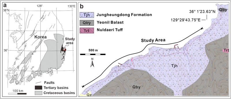
포항시 동해면 일대는 과거 장기반도, 구룡포반도, 영일반도로 일컫던 지역이지만 현재의 행정구역을 기준으로 호미반도로 기술하였다. 연구지역은 포항시 동해면 입암 1리 마을에서 입암 2리 선바우를 지나 하선대에 이르는 2 km의 구간이다(그림 1). 이 지역은 기존 1:50,000 대보도폭(Hwang and Kim, 2012)과 포항도폭(Um et al., 1964)의 경계부이며 실제 도폭에 기재된 암상과 해안에 노출된 암상은 큰 차이를 보인다. 특히 눌대리응회암이 분포하는 것으로 기재된 곳은 대부분 다양한 현무암질 각력암과 유문암질 응회암이 분포하는 것으로 확인된다. Son (2014)와 Hwang and Kim (2012)은 이 일대에 화산쇄설암이 분포하고 있으며 이를 중흥동층 분포지역으로 보고한 바 있다(그림 1). 그러나 Kim (2018)과 Kim et al. (2023)은 이 지역 일대의 중흥동층이 대부분 각지고 분급이 불량한 기반암과 데사이트질 화산물질을 포함하는 괴상 역암으로 주로 구성되며, 내부에 데사이트질 응회암을 포함한 특징을 보이고 있어 중흥리층으로 재 명명한바 있다.
3. 연구결과
연구지점은 암상, 층서, 선후관계 등의 특징에 따라 총 5개의 지점으로 구분하였다. 지점의 명칭은 지역 고유명을 따랐으며, 지명이 없는 경우 암상의 특징을 반영하여 1. 눌대리응회암, 2. 연일현무암, 3. 선바우각력암, 4. 힌디기응회암, 5. 하선대퇴적암으로 각각 명명하였다(그림 2).
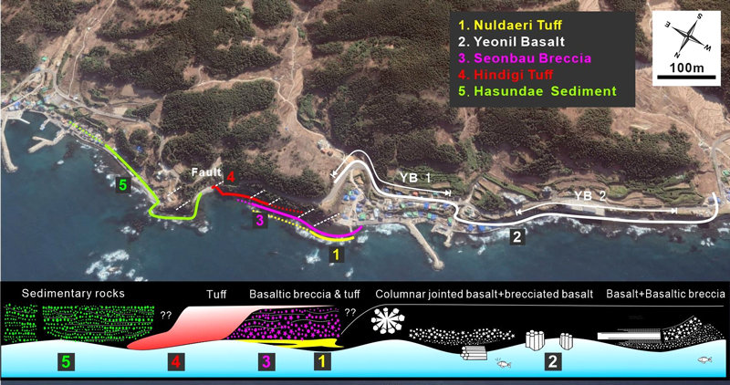
The study area was divided into five sections by lithology, stratigraphy, and chronological sequencing.
3.1. 눌대리응회암
눌대리응회암은 최초 Tateiwa (1924)에 의해 눌태리조면암질응회암으로 명명되었고, 장기분지 기저역암인 정천리역암의 직상부에 정합적으로 분포한다(Yoon, 1992; Cheon et al., 2012). 눌대리 응회암은 데사이트질 화산암류로 장기분지 전체에 광역적으로 대비되는 지층으로 설정되었고, 이후 Yun et al. (1994)과 Hwang and Kim (2012)은 이 응회암이 장기분지 전반에 분포하는 건층으로 인식하고 눌대리응회암으로 정의하였다.
눌대리응회암은 세립 화산회를 포함한 기질 내에 화산력 크기의 부석과 암편을 포함하며, 괴상의 조직을 보이나, 단위층에 따라 미약한 층리가 발달하기도 한다. 또한 암상에 따라 응회 각력암, 용결 응회암, (부석풍부) 화산력 응회암, 층상 (화산력) 응회암 등으로 구분되며, K-Ar 연대는 20.5-22.7 Ma (Kim et al.,1986; Lee et al., 1988; Hwang and Kim, 2012; Son et al., 2013), Zircon을 이용한 연대는 22.8-22.4 Ma로 알려져 있다(Kim et al., 2023).
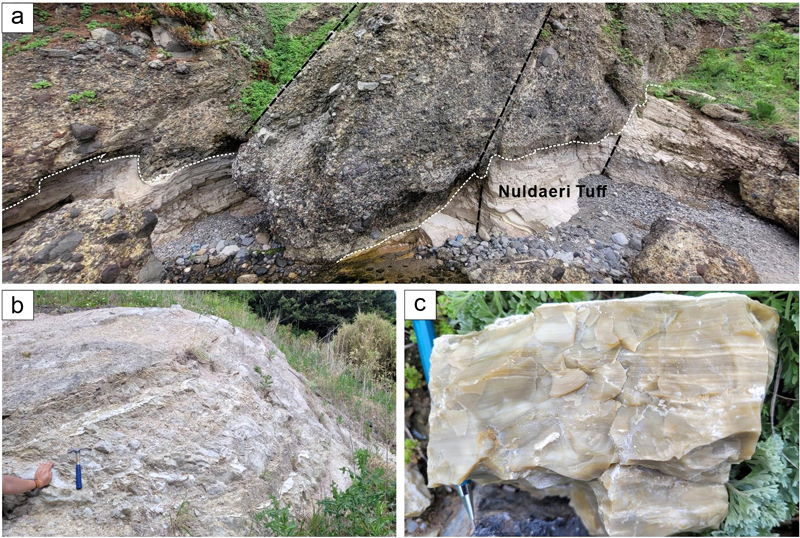
연구지역의 눌대리응회암은 입암 2리 선바우 주차장에서 해안을 따라 국부적으로 노출되어 있으며(그림 2), 두께는 최대 약 3 m 내외이며 측방으로 두께 변화가 크다. 응회암의 상부에는 현무암질 각력암이 분포한다(그림 3a). 응회암과 상부 각력암의 경계부에는 화산력 응회암이 피복하면서 형성된 침식면이나 하중구조가 발달한다. 눌대리응회암은 담황색 또는 담회색을 띠며 분급이 양호한 세립질 화산회 크기 입자들로 구성되고, 이질 암편은 거의 포함되어 있지 않다. 응회암은 대부분 괴상을 띠지만(그림 3b) 일부 희미한 엽층리가 발달하며 층리면을 따라 판상으로 쪼개지는 특성을 보인다. 부분적으로 응회암은 반투명한 담황색을 띠며 치밀한 형태로 나타나기도 하는데, 내부에는 수 mm 간격의 엽층리가 잘 발달하며 패각상으로 깨지는 특성을 보인다(그림 3c). 눌대리응회암은 소규모 단층에 의해 끊어지거나 휘어진 형태가 여러지점에서 관찰된다(그림 3a).
연구지역에서 관찰되는 눌대리응회암은 노출된 범위가 최대 3 m에 불과하여 층서적 위치와 기원을 해석하기에는 어려움이 있다. 그러나 해안에 국부적으로 노출된 눌대리응회암은 대부분 괴상의 특징을 보이는데 이는 플리니언 분출로 화산재들의 급격한 낙하에 의해 형성된 것으로 해석된다(Branney and Kokelaar, 2002). 일부 엽층리가 발달한 부분은 화성쇄설성 밀도류의 마지막 또는 후미에 따라오는 Buoyant coignimbrite ash cloud (or plume)에 의해 퇴적된 것으로 해석된다. 한편 응회암의 고결정도의 차이는 지표 천부의 변질 또는 열수변질 등을 받으면서 조직의 특성이 변화된 것으로 해석된다.
3.2. 연일현무암
연일현무암은 장기분지 일원에서 현무암질 화산활동으로 형성된 하부현무암질응회암, 상부현무암질응회암, 연일현무암및양휘석안산암을 포함한 지층을 말한다(Tateiwa, 1924; Yun et al., 1994). 연일현무암(Hwang and Kim, 2012)은 어일현무암(Yoon, 1992), 구룡포안산암의 일부(Yun et al., 1994), 뇌성산현무암질암(Kim et al., 2011)과 동일한 암석기재적 특징과 층서적 위치를 보여 서로 대비 가능한 동일 기원의 마그마로부터 유래된 동시대 화산활동의 산물로 해석되고 있다(Kim, 2018). 최근 연일현무암은 마그마의 관입과 이와 연결되어 분출한 용암이 수저분출 후 발생한 비폭발성 급랭 파쇄작용에 의해 형성된 일련의 화산활동 결과물로 재 해석한 바 있다(Kim, 2018).
연구지역의 연일현무암은 입암 1, 2리 남동부 방향의 계곡에서부터 북쪽 해안까지 연장되어 분포하는데, 암상의 특징과 산출지점의 위치에 따라 YB 1(입암 2리)과 YB 2(입암 1리)로 구분하였다(그림 2). YB 1은 입암 2리 마을 해안에서 약 300 m 길이로 연장된 동쪽 계곡을 따라 분포한다. YB 1은 공통적으로 괴상이며 기공이 거의 없고 치밀하며, 검은색 또는 암회색을 띤다. 반정으로는 휘석이 1-3 mm 크기로 나타나며 기질은 유리질로 구성되어 있다.
입암 2리 계곡 상류에 분포하는 YB 1은 괴상이며, 부분적으로 방사상 절리가 발달해 있다(그림 4a). 계곡 하류에는 괴상 현무암이 나타나지만, 현무암의 상부에는 절리의 파쇄도가 증가하면서 자가각력화 현무암(auto-brecciated basalt)으로 변해가는 양상을 보인다(그림 4b). 자가각력화된 역들은 수 cm에서 수십 cm 크기로 원마도가 불량하며 울퉁불퉁한 표면 특징을 보이고 역지지에서 기질로 변해가는 양상을 보인다(그리 4c). 각력들의 기질은 화산회 크기의 현무암 유리로 구성된다. 한편 해안에 분포하는 YB 1 현무암은 일부가 물밖으로 드러나 있는데, 괴상의 특징을 보이며 누워있는 주상절리와 수직의 주상절리가 발달한다(그림 4d).
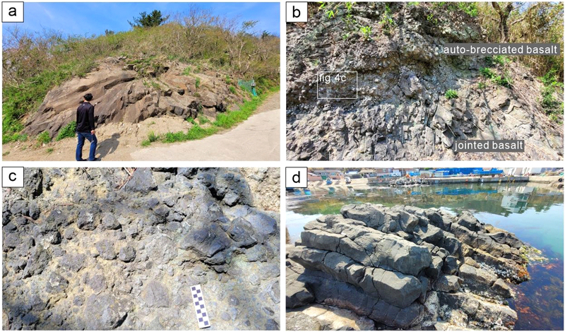
(a) YB 1 Yeonil basalt showing radial joints in the upstream part of the valley. (b) A cross-section of YB 1 with massive jointed basalt at the base overlain by auto-brecciated basalt. (c) Matrix-supported brecciated basalt at the top and basaltic clasts with angular and irregular outlines. (d) YB 1 Yeonil basalt showing horizontal joints in the coastal area.
한편 연일현무암 YB 2는 입암1리 북쪽 해안을 따라 약 200 m 범위에 걸쳐 단면이 잘 드러나 있다(그림 5a). 해안에 분포하는 YB 2는 최대 폭이 15 m 내외에서 점차 줄어들면서 3 m 내외로 감소하는 양상을 보인다(그림 5b). YB 2는 하부에 현무암질 응회암과 경계를 접하고 상부는 충적층(alluvium)이 피복한 양상을 보인다(그림 5a, 5b). 전체적으로 현무암은 괴상이지만 하부 응회암과 상부 충적층과의 경계부를 따라 절리가 발달한 특징을 보인다. 절리는 하부 현무암질 응회암과의 접촉면과 나란한 방향으로 발달하는데, 수평에서 점차 휘어지면서 수직으로 발달하는 양상을 보이기도 한다(그림 5b). 그리고 YB 2는 현무암질 응회암과의 접촉면에서 파쇄정도가 증가하면서 크고 작은 각력들로 파쇄된 자가각력화 현무암의 특징을 보인다(그림 5c). 파쇄된 각력들은 수 cm에서 1 m 이상의 크기이며 각력들은 기질 또는 역지지된 양상을 보인다. 대부분의 각력들은 내부에 절리가 잘 발달한 특징을 보인다(그림 5d).
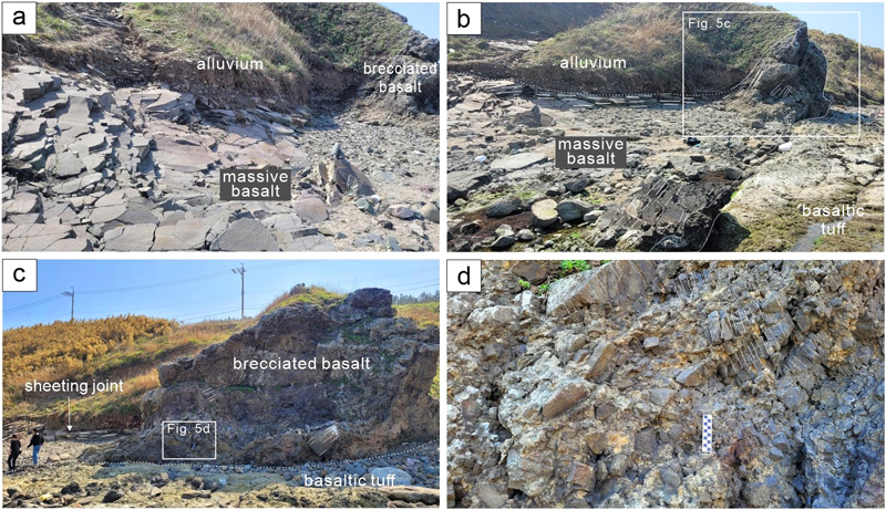
YB 2 Yeonil Basalt along the coast. (a, b) YB 2 basalt showing sheeting joints along the boundary with alluvium and basaltic tuff. These sheeting joints are fragmented auto-brecciated basalt with large and small angular blocks along the boundary between the basaltic tuff and alluivm. (c) Auto-brecciated basalt developed along the boundary with basaltic tuff. (d) The breccia developed sheeting joints and is fragmented into large and small pieces.
연일현무암 YB 2와 관입경계를 이루며 하부에 분포하는 현무암질 응회암은 두께가 3 m 내외이며 일부만 해안에 노출되어 있다. 현무암질 응회암은 수 cm 크기의 현무암편들이 기질 지지된 양상을 보인다(그림 5c). 역들은 대부분 괴상 또는 다공질의 현무암편이며 가장자리에는 최대 1 cm 두께의 급냉대가 발달하는 경우도 있다. 현무암질 응회암의 역 종류와 원마도, 황갈색 세립질 기질에 지지되어 있는 양상은 연일현무암(YB-1과 YB-2)의 자가각력질 현무암과는 구별되는 차이를 보인다.
연일현무암 YB 1과 2는 계곡에서 해안까지 연장되어 분포하고 괴상이며 반정의 종류와 크기 등이 동일한 것으로 볼 때 동일한 마그마에서 기원된 것으로 해석된다. 연일현무암에서 나타나는 절리는 짧은 거리에서 방향이 방사상, 수직, 수평으로 변하는 양상을 보인다. 또한 YB 1의 경우 괴상의 현무암에서 상부로 갈수록 각력질 현무암으로 변하고, YB 2의 경우 하부 현무암질 응회암과의 접촉면을 따라 불규칙한 절리의 발달이 증가하여 각력질 현무암으로 변해가는 양상을 보인다. 이러한 특징은 연일현무암이 지하천부를 관입한 마그마로서 접촉면을 따라 마그마가 식으면서 다양한 방향으로 절리가 발달하였고, 일부는 접촉면을 따라 급냉 파쇄되면서 자가각력화 현무암을 형성한 것으로 해석할 수 있다(Kokelaar 1986; Sohn, 1996; Jeon and Sohn, 2022). 마그마가 지하 천부 또는 다아아트림을 관입하면서 발생한 냉각에 따라 다양한 방향의 절리구조와 자가각력화 구조가 나타나는 특징은 여러 연구에서 보고된 바 있다(Goto and McPhie, 1996; White and Ross, 2011; Jeon et al., 2013).
3.3. 선바우각력암
선바우는 입암 2리 해안에 위치한 높이 약 10 m의 바위를 말하며, 입암(立岩)이란 마을 지명도 이를 한자로 표기한 것이다. 선바우각력암은 선바우 해안 입구에서 흰디기까지 250 m 구간에 분포하며 수 cm에서 수십 cm 크기의 현무암편과 분석(cinder or scoria)이 기질지지 되어있다(그림 2). 선바우각력암은 각력의 종류와 크기, 퇴적구조의 특성에 따라 하부에 괴상 현무암질 각력암(mBB: Massive ba-saltic breccia)과 상부에 층상 현무암질 응회각력암(sBTB: Stratified basaltic tuff breccia)으로 구분된다(그림 6).
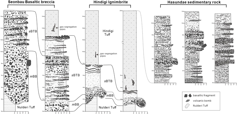
Sedimentary logs in the Seonbau-Haseondae area. Based on the type and size of the angular blocks and depositional structure, they are categorized as Massive basaltic breccia (mBB) in the lower part and Stratified basaltic tuff breccia (sBTB) in the upper part. Hindigi ignimbrite and Haseondae sediment are distributed above these.
① 암상
눌대리응회암을 피복하고 있는 괴상 현무암질 각력암(이하 퇴적상 mBB)은 두께가 최대 8 m이며, 동쪽(힌디기 방향)으로 가면서 두께가 점차 감소한다(그림 6).
퇴적상 mBB는 수십 cm에서 최대 1 m 크기의 각력들이 기질 또는 역지지되어 있다(그림 7a). 각력의 종류는 괴상의 현무암과 분석이 대부분을 차지하고 소량의 퇴적암편과 직하부 눌대리응회암편이 포함되어 있다(그림 7b). 현무암질 각력은 기공이 없는 괴상 또는 다공질이며, 일부 각력은 절리가 발달해 있다(그림 7b). 분석은 흑색 및 적색을 띠고 다공질이며, 일부는 방추형을 띠는 화산탄(volcanic bomb)의 형태로 산출된다(그림 7c). 화산탄의 표면에는 유리질 급냉대와 수축 절리가 발달하기도 한다(그림 7d). 퇴적상 mBB의 기질은 황갈색의 화산회(현무암질 유리) 크기 입자로 구성되어 있다(그림 7c). 전체적으로 퇴적상 mBB는 층리의 발달이 거의 없고 유수의 작용을 지시하는 퇴적구조가 나타나지 않아 쇄설성 역암과는 차이를 보인다(그림 6).
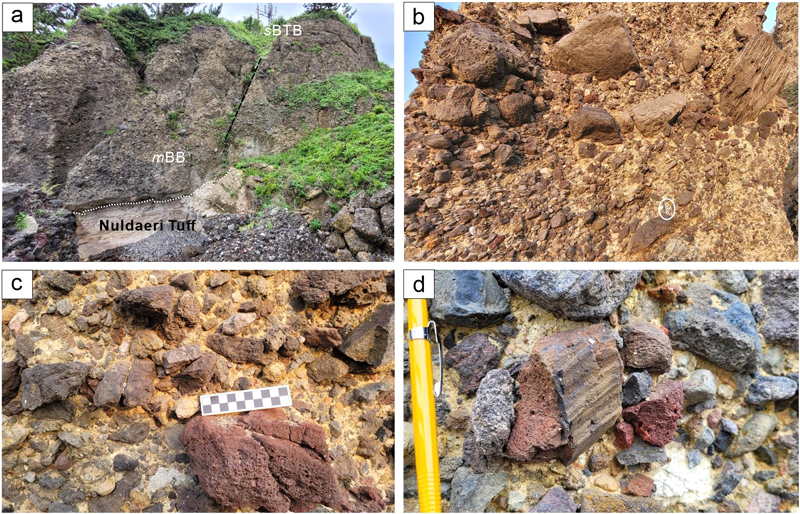
(a) The facies mBB in contact with the Nuldaeri Tuff in the lower part. An erosion surface develops along the boundary, and a fault line penetrates the two strata. (b, c) The facies mBB is massive and comprises either matrix or clast-supported basaltic angular blocks ranging from 1 m to multiple cm in size. Some basalt clasts show sheeting joints. The white circle represents a 10 cm scale bar. (d) Volcanic bomb with rapid cooling zones and wrinkled structures on the surface.
② 해석
퇴적상 mBB는 괴상이며, 분포범위가 좁고 두께가 최대 8 m에서 측방으로의 급격히 감소하며, 내부에 1 m 크기의 거력을 비롯하여 현무암질 각력들이 불규칙하게 섞여 있는 특징으로 볼 때 수증기-마그마성(phreatomagmatic) 화산활동에 의해 형성되었을 가능성이 있다(McClintock and White, 2006). 그러나 각력의 크기가 1 m 이상으로 매우 크고, 괴상의 현무암질 각력들의 비율이 매우 높다는 점을 볼 때 화성쇄설성 밀도류에 의해 퇴적되었을 가능성 보다는 용암돔의 붕괴에 의해 형성된 암괴-화산회류(block and ash flows)에 의해 퇴적되었을 것으로 추정된다(Fisher and Heiken, 1982; Vallance et al., 1995; Charbonnier and Gertisser, 2008). 이와 유사한 사례로 독도에 대한 연구결과 용암돔 내부로 스며든 외부수가 폭발적으로 기화하고 용암돔 내부의 마그마성 가스가 팽창하며 용암돔이 굵거나 잘게 파쇄되어 현무암질 각력암을 형성한 사례가 보고되기도 하였다(Park et al., 2022). 따라서 퇴적상 mBB는 지하 마그마 관입으로 현무암질 용암이 돔을 형성하다가 내부 마그마의 지속적인 압력 증가로 부풀어 오르다 붕괴되면서 형성된 것으로 해석된다. 또한 각력암의 기질을 구성하는 화산회는 팔라고나이트(palagonite)로 변질되었으며 일차(primary) 화산활동에 의해 형성되었음을 지시한다.
또 다른 가능성으로 퇴적상 mBB는 지진이나 산사태 등에 의해서도 각력암이 형성될 수 있지만, 역들의 종류가 다양하고 운반과정을 거치면서 각력들이 원마되고 분급작용이 발생하여 퇴적상 mBB 다른 양상으로 나타나게 된다.
① 암상
층상 현무암질 응회 각력암(이하 퇴적상 sBTB)은 퇴적상 mBB 상부에서 점이적으로 변해가는 양상을 보이며 두께는 최대 약 15 m이다(그림 6, 8a). sBTB는 각력층(breccia layer), 화산력층 그리고 화산회 층이 반복적으로 나타나고 상부로 갈수록 입자크기가 작아지는 상향세립화 경향을 보인다(그림 8b).
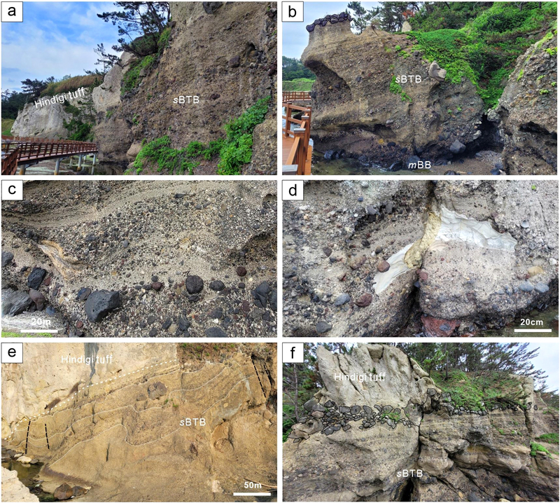
(a) The facies sBTB composed of massive and stratified lapilli tuff and locally found breccia blocks. (b) The facies sBTB has a high proportion of breccia in the lower part and the proportion of stratified lapilli tuff increases towards the upper part. (c) The facies sBTB comprises crudely stratified tuff, thinly stratified lapilli tuff, or undulatory-bedded lapilli tuff. The clasts mainly comprise black basalt, red scoria, and small amounts of Nuldaeri Tuff. (d) Fluidal-shaped Nuldaeri Tuff clasts show rip-up structures (e) Undulatory-bedded lapilli tuff layers in the upper part of the facies sBTB. (f) Basaltic blocks found along the boundary with Hindigi Ignimbrite at the top of the facies sBTB.
sBTB의 하부에는 각력층이 우세하게 분포하는데, 각력은 괴상 현무암과 분석으로 구성되며 희미한 층리를 보인다(그림 8c). 각력의 크기는 대부분 수-수십 cm이며, 최대 2 m 크기의 유동형(fluidal) 눌대리응회암편도 포함되어 있다(그림 8d). 각력층은 상부로 갈수록 화산회와 화산력의 비율이 증가하면서 각력층과 층상 화산력층이 교호하는 양상을 보인다(그림 8b). 각력층과 화산력층의 경계면은 뚜렷하지 않고, 침식면 없이 점이적(diffuse)이다(그림 8b, 8c).
sBTB의 상부는 화산력 크기 입자들로 구성되고 층리(layer)가 물결처럼 휘어진 파상층리 구조가 나타난다. 파형의 진폭은 10 cm 내외지만 상부에 거력이 분포하는 경우는 파형의 폭이 증가하는 경향을 보인다(그림 8e). 퇴적상 sBTB의 기질은 공통적으로 황갈색의 화산회(화산유리)로 구성되어 있다.
한편 퇴적상 sBTB와 힌디기응회암의 경계부를 따라 현무암 각력들이 역지지된 층이 부분적으로 나타난다. 각력은 대부분 수십 cm 크기이며, 대부분 괴상의 현무암과 소량의 다공질 현무암 및 분석으로 구성되어 있다(그림 8f).
② 해석
퇴적상 sBTB는 하부 퇴적상 mBB에서 뚜렷한 경계면 없이 점이적으로 역의 크기가 감소하고 층리의 발달이 양호해지는 양상을 보인다(그림 6). 또한 퇴적상 sBTB의 각력층, 화산력층 그리고 화산회층 사이에 지표작용에 의한 침식 및 재동의 흔적이 나타나지 않는 특징은 이들이 연속적인 화산활동에 의해 형성된 것임을 지시한다. 그리고 퇴적상 sBTB와 mBB는 공통적으로 괴상 현무암과 분석편이 우세하며, 기질 물질도 화산회(화산유리)로 구성되어 있어 동일한 마그마에서 기원되었음을 시사한다.
따라서 퇴적상 sBTB는 용암돔 붕괴나 폭발로 발생한 화산회류에 의해 퇴적상 mBB를 형성한 직후 하중 제거에 따른 지표의 압력 감소로 인해 발생한 현무암질 수증기-마그마성 화산활동에 의해 형성된 것으로 해석된다(Branney and Kokelaar, 2002; Gutmann, 2002; McClintock and White, 2006). 특히 각력층, 화산력층 그리고 화산회층이 뚜렷한 경계면이나 침식면 없이 반복적으로 나타나고 상부로 갈수록 입자크기가 작아지는 상향 세립화 경향을 보이는 특징은 수증기-마그마성 화산활동으로 형성된 화성쇄설성 밀도류(PDC: pyroclastic density current)의 특성에 따라 하부에 괴상 그리고 상부의 층상 화쇄류암을 형성한 것으로 해석할 수 있다(Charbonnier and Gertisser 2008; Park et al., 2022).
한편 퇴적상 sBTB 최상부에 힌디기응회암의과 경계부를 따라 역지지된 각력층은 초기 화산활동으로 형성된 용암돔의 잔존체가 수증기-마그마성 분화과정에서 폭발적으로 뿜어져 나와 서지(surge)나 탄도성 낙하(ballistic fall)에 의해 퇴적된 것으로 추정된다(Sohn and Chough, 1989).
3.4. 힌디기응회암
힌디기는 선바우 해안 둘레길에 위치해 있으며, 흰색을 띠는 해안 절벽을 일컫는 고유지명이다. 선바우각력암을 피복하고 있는 힌디기응회암은 북동쪽 해안에 위치한 하선대 일때까지 약 250 m 범위에 나타난다(그림 2, 8e). 힌디기응회암의 두께는 최대 약 15 m이며, 선바우 쪽으로 갈수록 두께가 얇아지다 첨멸되는 양상을 보인다(그림 9a). 괴상의 힌디기응회암은 다량의 부석편을 비롯해 세립에서 중립 화산력 크기의 흑색 또는 암회색의 현무암편과 적색의 분석편을 포함하고 있다(그림 9b). 힌디기응회암 내부에는 수직 내지 아수직 방향의 파이프 구조들이 불규칙한 그물형태로 나타나는데, 내부에 화산력 크기의 현무암, 분석, 부석편으로 채워져 있다(그림 9c).
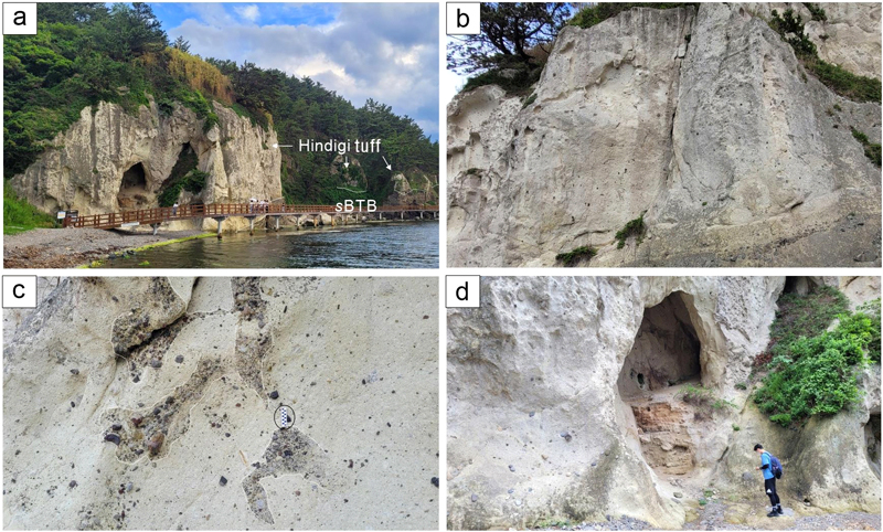
(a) Hindi Tuff in the upper part of the facies sBTB. (b) The Hindi Tuff is massive and contains abundant pumice fragments, including minor basaltic fragments. (c) Gas escape pipes in vertical or pipe-like forms. (d) A sea cave in the Hindi Tuff.
한편 힌디기 서쪽 지점에는 입구 직경이 5~6 m에 달하는 해식동굴이 2곳 분포하고, 힌디기응회암의 표면에는 크고 작은 타포니 구조들도 잘 발달해 있다.
힌디기응회암은 내부에 층리발달이 없고 다량의 부석편과 이질 암편을 함유한 특징으로 볼 때 부석이 풍부한(pumice-rich) 화성쇄설성 밀도류에 의해 퇴적된 화쇄류암(ignimbrite)으로 해석된다(Sparks et al., 1973; Branney and Kokelaar, 2002; Jeong et al., 2022). 화쇄류암 하부에 파이프 모양의 구조는 화쇄류암의 형성 당시 가스가 빠져나가고 그 사이에 조립질 암편들이 채워진 탈가스 구조(gas escape pipe) 구조로 해석된다(Walker, 1985).
힌디기 응회암에서 나타나는 측방의 두께 변화는 응회암이 퇴적된 이후 하성환경이 유지되면서 침식에 의한 결과로 해석된다.
현재 힌디기 해안에 노출된 암석만으로는 근원 화구의 위치를 추정하기는 어렵다. 그러나 최근 3기분지 충전물인 산성질 응회암들(팔조리응회암, 성동리층 내 응회암, 양포지역 응회암 등)은 분지 외부에서 기원한 것으로 해석되고 있다. 따라서 호미반도를 비롯한 구룡포 일대의 화산 및 지질형성사를 연구하는데 있어 산성질 응회암의 분포위치와 양상, 형성시기 등에 추가적인 조사가 필요하다.
3.5. 하선대퇴적암
하선대퇴적암은 힌디기응회암에서 먹바우 일대까지 해안을 따라 노출된 약 400 m 범위에 분포하며, 층의 최대 두께는 약 12 m이다. 하선대퇴적암은 주로 (사)층리가 발달한 사암과 역암이 교호하는 쇄설성 퇴적암의 특징을 보인다(그림 2, 10a).
사암은 입자크기가 중립에서 왕모래 크기이며, 분급은 보통에서 양호한 특징을 보인다. 사암은 수평층리가 잘 발달하며 깎고 채운 구조, 곡사층리(trough cross-bedding), 고각도 사구 사층리(high-angle dune cross-bedding), 연흔 사층리(ripple cross-lamination) 등의 퇴적구조가 잘 발달해 있다(그림 10a, 10b). 사암층 내부에 부분적으로 수cm 두께의 엽층리가 발달한 이암이 협재되는 경우도 있다(그림 10a).
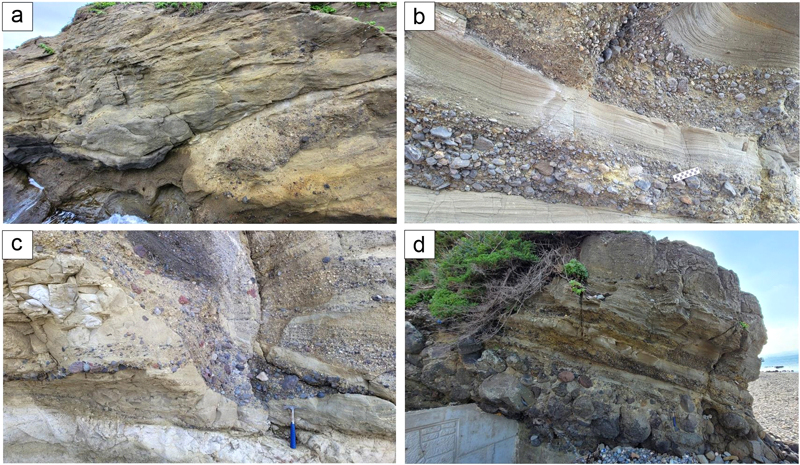
(a) Crudely stratified and cross-bedded sandstone. (b) There are alternations between well-stratified sandstone and normal graded conglomerate. (c) The conglomerate layer is eroding the sandstone layer in a chute-like channel. (d) Stratified sandstone is distributed in the upper part, and normal graded massive conglomerate is distributed in the lower part.
역암은 주로 아각형~아원형의 잔자갈(pebble)에서 거력 크기의 역들로 구성되어 있으며 역의 조성은 현무암, 분석, 유문암, 안산암, 부석편 등으로 구성되며 소량이 변성기원 암편들도 포함되어 있다. 역암은 입자크기에 따라 잔자갈 크기가 우세한 층과 왕자갈에서 거력 크기가 우세한 층으로 구분할 수 있다.
잔자갈 크기의 역암층은 주로 사암과 교호하는 양상을 보이는데, 정점이 층리가 발달하고 역 또는 기질 지지된 특징을 보인다. 또한 역들의 원마도가 보통에서 양호하며, 주로 괴상 및 다공질 현무암의 비율이 높은 특징을 보인다(그림 10b). 일부 잔자갈 크기의 역암층은 괴상 및 역점이 층리를 보이며, 측방 연장은 불량하고 사암을 침식하는 소규모 하도(chute) 형태로 나타나기도 한다(그림 10c).
왕자갈에서 거력 크기의 역암층은 분급이 불량한 기질에 역 또는 기질 지지되어 있다. 역의 원마도는 아원형이며, 역의 종류는 괴상 또는 다공질의 현무암과 분석이 대부분을 차지하며 정점이 층리가 발달한다(그림 10d).
하선대 일대는 주로 사암과 역암으로 구성되며 층리의 발달이 뚜렷하고 침식구조 등이 잘 발달한 특징으로 볼 때 육상에서 쌓인 쇄설성 퇴적암으로 해석된다. 특히 사암에서 보이는 층리, 사층리, 연흔 사층리, 사구 사층리 등은 육상환경의 하천 등에서 판류(sheet flood) 및 고농도 홍수류(hyperconcentrated flood flow)에 의해 퇴적된 것으로 추정된다(Middleton, 1970; Pierson and Scott, 1985; Sohn et al., 1999). 반면 희미한 층리를 보이는 괴상 역암과 역점이를 보이는 역암층은 하천환경에서의 간헐적으로 발생하는판류, 고농도 홍수류 또한 간헐적인 홍수에 의해 만들어진 것으로 해석된다(Fisher, 1983).
하선대퇴적암의 역들은 대부분 현무암, 분석, 유문암, 부석편 등으로 구성되어 있는데, 이러한 특징은 하선대퇴적암 선바우와 힌디기 화산활동 이후에 퇴적되었음을 지시한다. 따라서 하선대 구간은 힌디기 화산분화 종료 후(post- eruptive)의 하천환경에서 재퇴적작용에 의해 형성된 퇴적층으로 해석된다.
4. 토 의
4.1. 선바우-하선대 구간 지질 형성사
선바우에서 하선대 일대는 약 22.7-20.5 Ma (Kim et al., 1986; Lee et al., 1988) 또는 22.8-22.4 Ma (Kim et al., 2023) 기간동안 산성질 화산활동이 발생하여 눌대리응회암이 형성되었다. 입암 2리 해안에 국부적으로 노출된 눌대리응회암은 주로 급격한 화산재 낙하에 의해 형성된 화산회 응회암으로 해석된다. 이 응회암은 후기 천부 열수변질 등을 거치면서 벤토나이트나 오팔 등으로 변질되었고 구조적으로는 단층운동이 발생하였다.
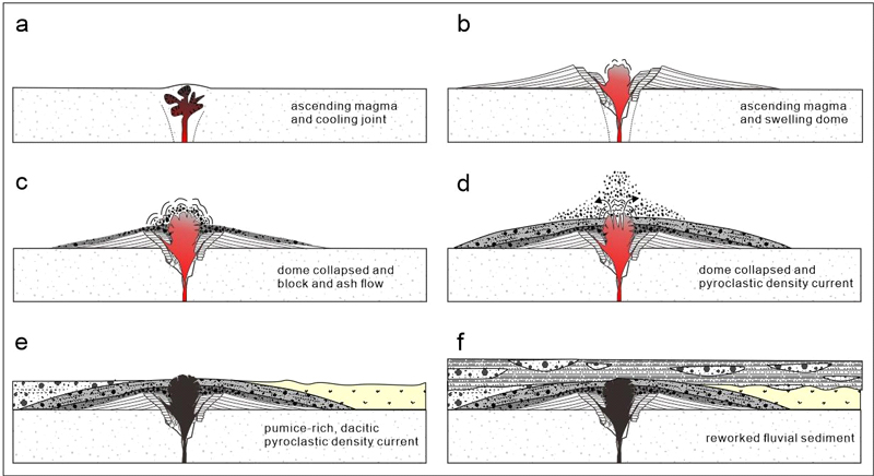
이후 이 일대에서 현무암질 마그마가 응회암을 뚫고 관입하면서 여러방향의 냉각절리를 형성하였다(그림 11a; Kokelaar 1986; Jeon et al., 2022; Go et al., 2023). 이 과정에서 응회암과의 접촉면을 따라 급격한 냉각과 마그마성 가스의 팽창 등이 일어나 절리의 파쇄도가 증가하여 국부적으로 자가각력암이 형성되었다(Park et al., 2022). 현재 이 각력암은 입암 1리 해안에 10 m 높이의 언덕지형으로 남아있고 방향에 따라 방사상, 수평, 수직의 절리가 발달한 관입체는 입암 2리 계곡 상류와 해안에 분포한다.
한편 마그마의 지하 천부 관입으로 인해 지표 천부가 부풀어 올라 크립토돔(cryptodome)이 형성되었다(그림 11b). 그리고 지하 마그마의 계속된 관입과 상승으로 인해 지표의 변형과 불안정한 돔의 급작스러운 사면붕괴가 일어나 대규모 암괴-화산회류가 발생하였다(Fisher and Heiken 1982; Ui, 1983; Charbonnier and Gertisser, 2008; Burchardt et al., 2019; Park et al., 2022). 이 암괴-화산회류로 인해 선바우 일대에 괴상의 현무암질 각력암이 단기간에 쌓이게 되었다(그림 11c). 암괴-화산회류로 인한 지표 압력의 감소 또는 감압(decompression)은 지하 천부에 위치한 크립토돔의 폭발을 유발시켰다. 이 과정에서 화성쇄설성 밀도류가 발생하여 층상 현무암질 각력암이 퇴적되었다(그림 11d; Donnadieu and Merle, 1998; Donnadieu et al., 2001; Németh and Martin, 2007; Sulpizio et al., 2014). 이후 인근 또는 분지 외부에서 화산활동이 발생하여 이 일대에 힌디기응회암을 쌓이게 된 것으로 해석된다(그림 11e; Bahk and Chough, 1996).
이후 화산분화가 종료되고 하성환경이 유지되면서 인근에 쌓인 현무암질 및 유문암질 화산쇄설물이 지표작용에 의해 운반 및 재퇴적 되면서 층리 및 사층리가 발달한 하선대 일대의 퇴적층을 형성한 것으로 해석된다. 그리고 이 과정에서 간헐적으로 발생한 홍수 등에 의해 괴상의 역암층이 중간중간 협재된 것으로 추정된다(그림 11f).
4.2. 선바우-하선대 구간의 지질학적 중요성
선바우에서 하선대 일대의 지층에서는 눌대리응회암이 분출한 이후 이 일대에서 독특한 화산활동이 발생했음을 보여준다. 먼저 연일현무암이 지하 천부를 관입하고 냉각되면서 다양한 방향으로 절리가 발달한 현무암과 자가각력질 현무암을 형성하였다. 그리고 선바우 일대에서는 마그마 관입으로 크립토돔이 형성되고 불안정한 지표의 변형과 돔의 붕괴로 발생한 암괴-화산회류에 의해 선바우 괴상 현무암질 각력암이 형성되었다. 그리고 사면의 붕괴는 지표의 압력 감소와 감압으로 이어져 층상 현무암질 각력암이 퇴적되었다. 그리고 인근 또는 분지외부에서 또 다른 산성질 화산분화가 발생하였음을 보여주고 있다.
선바우 일대의 각력암에서는 유수의 작용을 지시하는 침식, 재동면이 전혀 나타나지 않고 역질부와 사질부가 점이적인 경계를 보이는 특징은 일반적인 하천 퇴적과정에서 볼 수 없는 특징이다. 이처럼 현무암질(혹은 데사이트질)에서 유문암질 화산활동으로 연속되는 화산활동의 사례는 1980년 St. Helens 화산 분화 시 화산체의 정상부에 데사이트질 용암돔이 형성되면서 점차 부풀어 오르다가 마그마 내부의 압력이 증가하면서 용암돔이 붕괴하여 암설사태를 유발하고 동시에 화쇄류가 흘러나간 양상과 유사하다(e.g., Fink et al., 1990; Swanson and Holcomb, 1990; Druitt, 1992; Clynne et al., 2005; Burchardt et al., 2019).
그리고 화산활동이 종료되고 하성환경이 지속되면서 화산쇄설물이 재퇴적 과정을 거치면서 다양한 퇴적구조를 지닌 화산쇄설성 퇴적층을 형성하였다. 특히 하선대 구간에 분포하는 사암과 역암에 포함된 다양한 퇴적구조는 교과서에 소개될 만큼 그 종류와 형태가 다양하다.
4.3. 선바우-하선대 구간의 지질트레일 활용방안
선바우 하선대 구간은 길이는 짧지만 다양한 암석과 지질구조 및 퇴적구조를 관찰할 수 있다. 특히 호미반도 일대에서 발생한 화산활동과 퇴적활동을 직접 눈으로 관찰할 수 있다는 점에서 지질트레일 코스로 매우 적합한 지역이라 할 수 있다.
먼저 입암 2리 마을에는 이 지역의 기반암인 눌대리응회암을 볼 수 있으며, 응회암의 변질로 인한 벤토나이트와 오팔 등의 변질광물을 눈으로 직접 확인할 수 있다. 그리고 지하 천부 관입체의 냉각에 의해 형성된 다양한 절리의 구조를 관찰할 수 있다. 그리고 마그마의 관입에 따라 돔이 형성되고 뒤이어 붕괴, 압력감소에 따른 화산분출과 퇴적작용의 연속적인 과정을 선바우에서 힌디기 일대에서 확인할 수 있다. 그리고 이 화산쇄설물이 다시 하천을 통해 흘러가면서 남긴 다양한 퇴적구조를 하선대 일대에서 관찰할 수 있다.
따라서 선바우에서 하선대 구간은 독특한 화산활동과 퇴적활동을 보여주는 지질교육 장소이자 뛰어난 경관을 지닌 곳이다. 더불어 뛰어난 해안경과 해양생태가 잘 보존되어 있어 이를 연계하여 탐방인프라를 조성한다면 동해안 지질공원을 대표할 수 있는 트레일 코스로 활용될 수 있을 것이라 생각된다.
5. 결 론
경북 동해안 지질공원 호미반도 해안둘레길은 중생대 퇴적층과 마이오세 퇴적분지 지층을 기반으로 다양한 생태 및 역사문화 요소들을 포함하고 있다. 특히 선바우길은 뛰어난 해안경관과 다양한 지질유산을 보유하고 있으며, 호미반도 일대는 동해의 열림에 따라 발생한 구조운동과 화산활동, 그리고 퇴적환경의 변화를 보여주는 중요한 지층이다.
선바우길 일대는 하부로부터 눌대리응회암, 연일현무암, 선바우각력암, 힌디기응회암, 하선대퇴적암이 분포하고 있다. 눌대리응회암은 해안을 따라 국부적으로 노출되어 있고 화산회 응회암의 특징을 보인다. 연일현무암은 방사상, 수직, 수평 절리가 발달하고 상하부 접촉면 주변에서는 자가각력암의 양상을 보인다. 이러한 특징은 연일현무암이 지하 천부 관입체로 여러 방향으로 관입하고 냉각되면서 다양한 방향의 절리를 형성하고 접촉면에서는 급냉 파쇄되면서 자가각력암을 형성한 것으로 추정된다.
눌대리응회암을 피복하는 선바우각력암은 각력의 종류, 크기, 암상에 따라 하부 괴상 현무암질 각력암(퇴적상 mBB)과 상부 층상 현무암질 응회 각력암(퇴적상 sBTB)으로 구분되며 공통적으로 현무암편, 분석, 이질암편을 포함하고 있다. 퇴적상 mBB는 마그마 관입으로 형성된 용암돔이 부풀어 오르다 붕괴하면서 발생한 암괴-화산회류에 의해 형성된 것으로 해석된다. 그리고 상부 퇴적상 sBTB는 각력층, 화산력층 그리고 화산회 층이 반복해서 나타나고 상s향세립화 경향을 보인다. sBTB는 암괴-화산회류에 의해 퇴적상 mBB를 형성한 후 하중 제거에 따른 지표 압력의 감소로 발생한 화성쇄설성 밀도류에 의해 퇴적된 것으로 해석된다.
괴상의 힌디기응회암은 다량의 부석편, 화산력, 화산회로 구성되며, 탈가스 구조가 발달하여 육성환경에서 퇴적된 화쇄류암으로 해석된다. 힌디기응회암 상부의 하선대 퇴적층은 사암과 역암이 교호하는 쇄설성 퇴적암의 특징을 보이는데, 하천환경에서 간헐적으로 발달하는 홍수류에서 발생하는 다양한 퇴적작용(판류, 고농도 홍수류, 쇄설류 등)에 의해 퇴적되었음을 지시한다.
선바우 하선대 구간은 지하 마그마의 상승과 관입에 따른 돔 형성과 사면붕괴, 화산활동 그리고 재퇴적과정을 한눈에 볼 수 있는 흔치 않은 지질학적 사례라 할 수 있으며 지질교육 및 지질관광 자원으로 활용될 수 있을 것이다.
References
-
Bahk, J.J. and Chough, S.K., 1996, An interplay of syn-and intereruption depositional processes: the lower part of the Jangki Group (Miocene), SE Korea. Sedimentology, 43, 421-438.
[https://doi.org/10.1046/j.1365-3091.1996.d01-19.x]

- Branney, M.J. and Kokelaar, P., 2002, Pyroclastic density currents and the sedimentation of ignimbrites. Geological Society of London, 27, 143 p.
-
Burchardt, S., Mattsson, T., Palma, J.O., Galland, O., Almqvist, B., Mair, K., Jerram, D.A., Hammer, Ø. and Sun, Y., 2019, Progressive growth of the Cerro Bayo cryptodome, Chachahuén volcano, Argentina-Implications for viscous magma emplacement. Journal of Geophysical Research: Solid Earth, 124, 7934-7961.
[https://doi.org/10.1029/2019JB017543]

-
Charbonnier, S.J. and Gertisser, R., 2008, Field observations and surface characteristics of pristine block-and-ash flow deposits from the 2006 eruption of Merapi Volcano, Java, Indonesia. Journal of Volcanology and Geothermal Research, 177, 971-982.
[https://doi.org/10.1016/j.jvolgeores.2008.07.008]

-
Cheon, Y., Son, M., Song, C.W., Kim, J.S. and Sohn, Y.K., 2012, Geometry and kinematics of the Ocheon Fault System along the boundary between the Miocene Pohang and Janggi basins, SE Korea, and its tectonic implications. Geosciences Journal, 16, 253-273.
[https://doi.org/10.1007/s12303-012-0029-0]

-
Clynne, M.A., Ramsey, D.W. and Wolfe, E.W., 2005, Pre-1980 eruptive history of Mount St. Helens, Washington US Geological Survey, David A. Johnston Cascades Volcano Observatory, 4 p, http://pubs.usgs.gov/fs/2005/3045, .
[https://doi.org/10.3133/fs20053045]

-
Donnadieu, F. and Merle, O., 1998, Experiments on the indentation process during cryptodome intrusions: new insights into Mount St. Helens deformation. Geology, 26, 79-82.
[https://doi.org/10.1130/0091-7613(1998)026<0079:EOTIPD>2.3.CO;2]

-
Donnadieu, F., Merle, O. and Besson, J.C., 2001, Volcanic edifice stability during cryptodome intrusion. Bulletin of Volcanology, 63, 61-72.
[https://doi.org/10.1007/s004450000122]

-
Druitt, T., 1992, Emplacement of the 18 May 1980 lateral blast deposit ENE of Mount St. Helens, Washington. Bulletin of Volcanology, 54, 554-572.
[https://doi.org/10.1007/BF00569940]

-
Fink, J.H., Malin, M.C. and Anderson, S.W., 1990, Intrusive and extrusive growth of the Mount St Helens lava dome. Nature, 348, 435-437.
[https://doi.org/10.1038/348435a0]

-
Fisher, R.V., 1983, Flow transformations in sediment gravity flows. Geology, 11, 273-274.
[https://doi.org/10.1130/0091-7613(1983)11<273:FTISGF>2.0.CO;2]

-
Fisher, R.V. and Heiken, G., 1982, Mt. Pelee, Martinique: May 8 and 20, 1902, pyroclastic flows and surges. Journal of Volcanology and Geothermal Research, 13, 339-371.
[https://doi.org/10.1016/0377-0273(82)90056-7]

-
Go, S.Y., Jeong, J.O. and Sohn, Y.K., 2023, Ash aggregation processes in a basaltic tuff ring (Songaksan, Jeju Island, Korea): Controls of diatreme conditions and transport processes. Journal of Volcanology and Geothermal Research, 435, 107772.
[https://doi.org/10.1016/j.jvolgeores.2023.107772]

-
Goto, Y. and McPhie, J., 1996, A Miocene basanite peperitic dyke at Stanley, northwestern Tasmania, Australia. Journal of Volcanology and Geothermal Research, 74, 111-120.
[https://doi.org/10.1016/S0377-0273(96)00043-1]

-
Gutmann, J.T., 2002, Strombolian and effusive activity as precursors to phreatomagmatism: eruptive sequence at maars of the Pinacate volcanic field, Sonora, Mexico. Journal of Volcanology and Geothermal Research, 113, 345-356.
[https://doi.org/10.1016/S0377-0273(01)00265-7]

- Hwang, S.K. and Kim, Y.B., 2012, Explanatory note of the Daebo Sheet (1:50,000). Korea Institute of Geoscience and Mineral Resources, 67 p (in Korean with English abstract).
-
Jeon, Y., Park, K.H. and Sohn, Y.K., 2022, Hydrovolcanic activity on a continental shelf inferred from the subsurface diatreme- and crater-filling deposits of Jeju Island, Korea. Bulletin of Volcanology, 84.
[https://doi.org/10.1007/s00445-022-01599-9]

- Jeon, Y., Ryu, C.K., Yoon, W., Kang, S. and Song, S., 2013, Characteristics and interpretation of subsurface diatreme deposits from western Jeju Island. Journal of the Geological Society of Korea, 49, 537-551 (in Korean with English abstract).
-
Jeon, Y. and Sohn, Y.K., 2022, Interactions of pāhoehoe and ‘a ‘ā lavas and fluvial sediments on an alluvial plain (the Cretaceous Gyeongsang Basin, Republic of Korea). Journal of Volcanology and Geothermal Research, 432, 107699.
[https://doi.org/10.1016/j.jvolgeores.2022.107699]

-
Jeong, J.O., Jeon, Y. and Sohn, Y.K., 2022, Geological record of a Cretaceous seismic event paired with multiple volcanic eruptions. Terra Nova, 34, 83-90.
[https://doi.org/10.1111/ter.12565]

- Kim, K.H., Won, J.K., Matsuda, J., Nagao, K. and Lee, M.W., 1986, Paleomagnetism and K-Ar age of volcanic rocks from Guryongpoarea, Korea. Journal of Korean Institute of Mining Geology, 19, 231-237 (in Korean with English abstract).
- Kim, M.-C., 2018, Characteristics of basin fills and structural evolution of the Early Miocene Janggi Basin, SE Korea, Ph.D. Thesis, Pusan National University, Pusan, 230 p (in Korean with English abstract).
-
Kim, M.-C., Gihm, Y.S., Son, E.-Y., Son, M., Hwang, I.G., Shinn, Y.J. and Choi, H., 2015, Assessment of the potential for geological storage of CO2 based on structural and sedimentologic characteristics in the Miocene Janggi Basin, SE Korea. Journal of the Geological Society of Korea, 51, 253-271 (in Korean with English abstract).
[https://doi.org/10.14770/jgsk.2015.51.3.253]

-
Kim, M.-C., Jeong, R.Y., Gahng, G., Chae, Y.U., Song, C.W., Kang, H.C. and Son, M., 2023, Incipient subsidence and subsequent clockwise rotation of the Miocene Janggi onshore basin, SE Korea, associated with the back-arc opening of East Sea. Marine Geophysical Research, 44.
[https://doi.org/10.1007/s11001-023-09520-5]

- Kim, M.-C., Kim, J.-S., Jung, S., Son, M. and Sohn, Y.K., 2011, Bimodal Volcanism and Classification of the Miocene Basin Fill in the Northern Area of the Janggi-myeon, Pohang, Southeast Korea. Journal of the Geological Society of Korea, 47, 585-612 (in Korean with English abstract).
-
Kokelaar, P., 1986, Magma-water interactions in subaqueous and emergent basaltic. Bulletin of Volcanology, 48, 275-289.
[https://doi.org/10.1007/BF01081756]

- Lee, H.K., Moon, H.-S., Min, K.D., Kim, I.-S., Yun, H. and Itaya, T., 1992, Paleomagnetism, Stratigraphy and Geologic Structure of the Tertiary Pohang and Changgi Basins; K-Ar Ages for the Volcanic Rocks. Journal of Korean Institute of Mining Geology, 25, 337-349 (in Korean with English abstract).
- Lee, M.W., Won, C.K., Kim, K.H. and Noh, J.H., 1988, Geology and Petrology of Volcanic Rocks in Guryongpo, Korea. Journal of the Geological Society of Korea, 24, 1-15 (in Korean with English abstract).
-
McClintock, M. and White, J.D., 2006, Large phreatomagmatic vent complex at Coombs Hills, Antarctica: wet, explosive initiation of flood basalt volcanism in the Ferrar-Karoo LIP. Bulletin of Volcanology, 68, 215-239.
[https://doi.org/10.1007/s00445-005-0001-1]

- Middleton, G.V., 1970, Experimental studies related to flysch sedimentation. Flysch sedimentolgy in North America, 7, 253-272.
-
Németh, K. and Martin, U., 2007, Shallow sill and dyke complex in western Hungary as a possible feeding system of phreatomagmatic volcanoes in “soft-rock” environment. Journal of Volcanology and Geothermal Research, 159, 138-152.
[https://doi.org/10.1016/j.jvolgeores.2006.06.014]

-
Park, S.I., Jeong, J.O. and Sohn, Y.K., 2022, Volcaniclastic sedimentation associated with trachytic volcanism in an oceanic intraplate volcano (Dokdo volcano, Republic of Korea). Bulletin of Volcanology, 84.
[https://doi.org/10.1007/s00445-022-01595-z]

-
Pierson, T.C. and Scott, K.M., 1985, Downstream dilution of a lahar: transition from debris flow to hyperconcentrated streamflow. Water Resources Research, 21, 1511-1524.
[https://doi.org/10.1029/WR021i010p01511]

-
Sohn, Y.K., 1996, Hydrovolcanic processes forming basaltic tuff rings and cones on Cheju Island, Korea. Geological Society of America Bulletin, 108, 1199-1211.
[https://doi.org/10.1130/0016-7606(1996)108<1199:HPFBTR>2.3.CO;2]

-
Sohn, Y.K. and Chough, S.K., 1989, Depositional processes of the Suwol bong tuff ring, Cheju Island (Korea). Sedimentology, 36, 837-855.
[https://doi.org/10.1111/j.1365-3091.1989.tb01749.x]

-
Sohn, Y.K., Ki, J.S., Jung, S., Kim, M.-C., Cho, H. and Son, M., 2013, Synvolcanic and syntectonic sedimentation of the mixed volcaniclastic-epiclastic succession in the Miocene Janggi Basin, SE Korea. Sedimentary Geology, 288, 40-59.
[https://doi.org/10.1016/j.sedgeo.2013.01.002]

-
Sohn, Y.K., Rhee, C.W. and Kim, B.C., 1999, Debris flow and hyperconcentrated flood-flow deposits in an alluvial fan, northwestern part of the Cretaceous Yongdong Basin, Central Korea. The Journal of Geology, 107, 111-132.
[https://doi.org/10.1086/314334]

- Son, M., Kim, J.-S., Chong, H.-Y., Lee, Y.H. and Kim, I.-S., 2007, Characteristics of the Cenozoic crustal deformation in SE Korea and their tectonic implications. The Korean Society of Petroleum Geology, 13, 1-16 (in Korean with English abstract).
- Son, M., Song, W.S., Kim, M.-C., Cheon, Y., Jung, S., Cho, H., Kim, H.-G., Kim, J.S. and Sohn, Y.K., 2013, Miocene Crustal Deformation, Basin Development, and Tectonic Implication in the southeastern Korean Peninsula. Journal of the Geological Society of Korea, 49, 93-118 (in Korean with English abstract).
- Son, Y.W., 2014, Volcanology of the Nuldaeri Tuff in Janggi Peninsula, Korea. Andong National University, 60 p, http://www.riss.kr/link?id=T13547872, .
-
Sparks, R.S.J., Self, S. and Walker, G.P., 1973, Products of ignimbrite eruptions. Geology, 1, 115-118.
[https://doi.org/10.1130/0091-7613(1973)1<115:POIE>2.0.CO;2]

-
Sulpizio, R., Dellino, P., Doronzo, D.M. and Sarocchi, D., 2014, Pyroclastic density currents: state of the art and perspectives. Journal of Volcanology and Geothermal Research, 283, 36-65.
[https://doi.org/10.1016/j.jvolgeores.2014.06.014]

-
Swanson, D.A. and Holcomb, R.T., 1990, Regularities in growth of the Mount St. Helens dacite dome, 1980-1986, In Fink, John, ed., The mechanics of lava flow emplacement and dome growth: (Berlin, Springer-Verlag), International Association of Volcanology and Chemistry of the Earth’s Interior, Proceedings in Volcanology, 2, 3-24.
[https://doi.org/10.1007/978-3-642-74379-5_1]

- Tateiwa, I., 1924, 1:50,000 Geological atlas of Chosen, No. 2, Ennichi, Kuryuho and Choyo sheets. Geological Survey of Chosen (in Japanese).
-
Ui, T., 1983, Volcanic dry avalanche deposits-identification and comparison with nonvolcanic debris stream deposits. Journal of Volcanology and Geothermal Research, 18, 135-150.
[https://doi.org/10.1016/0377-0273(83)90006-9]

- Um, S.H., Lee, D.W. and Park, B.S., 1964, Geological report of the Pohang Sheet (1:50,000). Geological Survey of Korea, 21.
-
Vallance, J.W., Siebert, L., Rose Jr, W.I., Girón, J.R. and Banks, N.G., 1995, Edifice collapse and related hazards in Guatemala. Journal of Volcanology and Geothermal Research, 66, 337-355.
[https://doi.org/10.1016/0377-0273(94)00076-S]

-
Walker, G.P., 1985, Origin of coarse lithic breccias near ignimbrite source vents. Journal of Volcanology and Geothermal Research, 25, 157-171.
[https://doi.org/10.1016/0377-0273(85)90010-1]

-
White, J.D. and Ross, P.S., 2011, Maar-diatreme volcanoes: a review. Journal of Volcanology and Geothermal Research, 201, 1-29.
[https://doi.org/10.1016/j.jvolgeores.2011.01.010]

- Yoon, S., 1992, Geology of the Tertiary Yangnam and Pohang basins, Korea. Bulletin of the Mizunami Fossils Museum, 19, 13-31.
- Yun, S.H., Kim, J.S., Ock, S.S., Hong, H.G. and Kim, H.S., 1994, Petrology of volcanic rocks in the Yeongil Peninsula, Southeastern Korea. Journal of the Korean Earth Science Society, 15, 126-138 (in Korean with English abstract).

