해저 테프라층서 연구에 의한 동해 주변 화산의 플리니식 분화 역사 복원
초록
동해에서 채취된 해저퇴적물에는 다양한 화산들의 플리니식 분화에 의해서 장거리 이동되어 쌓인 테프라층(tephra layer)이 보고되었다. 플리니식 화산 분화는 분연주(eruption columns)가 대류권계면(tropopause)을 지나 성층권까지 도달하며, 지역에 따라서 형성된 제트류에 의해서 테프라가 기원화산체로부터 장거리 이동이 특징이다. 화산의 지리적 위치에 따라 대류권계면의 높이와 제트류의 방향과 세기가 차이가 나는데, 테프라의 장거리 이동 범위를 결정하는 주요 인자는 마그마 유입량(magma discharge rate)과 화산의 지리적 위치이다. 동해 해저퇴적물에서 발견된 테프라 연구는 기존 육상 연구에서 보고된 백두산, 울릉도, 일본 화산들의 플리니식 분화 역사 이외에 더 많은 정보를 제공하였다. 그리고 동해 한국대지에 위치하는 해저화산의 후기 플라이스토세 폭발적인 분화가 처음으로 밝혀졌다. 해저 테프라층서 연구는 다양한 규모(퇴적분지내 또는 육상-해양 연결)의 시간층서적 도구를 제공하며, 화산 분화 당시의 고해양학적(해류와 저서생물의 활동) 또는 고기후학적(제트류 세기와 파형) 특성도 규명할 수 있다. 현재까지의 동해 해저 테프라층서 연구를 통해서 동해 주변 화산들의 플리니식 분화 역사가 충분히 밝혀지지 않았으며, 앞으로 동해 형성 이후의 동해 주변 화산들의 플리니식 화산 분화에 대한 종합적인 연구가 필요하다. 동해 주변 화산들의 플리니식 분화 역사 복원은 향후 한반도에 영향을 미칠 수 있는 화산 재해에 대한 방지 계획의 수립에도 도움을 줄 것이다.
Abstract
Tephra layers have been reported in marine sediments from East Sea cores, reflecting long-range transportation of tephra by Plinian eruptions of various volcanoes around the East Sea, Korea. In Plinian eruptions, the eruption column reaches the stratosphere over a tropopause that has developed regionally in the jet stream, enabling long-distance transport of tephra from the source volcano. The direction and strength of the jet stream and height of the tropopause differ substantially from the geographic location of the source volcano. This may be a major factor in the long-range transport of tephra, in addition to the magma discharge rate during the eruption. Marine tephrostratigraphic studies provide more detailed information on the Plinian eruptions history of the Baekdusan and Ulleungdo volcanoes and several other volcanoes in the Japanese Islands around the East Sea, compared to previous volcanological studies around these volcanoes. Furthermore, the features of explosive eruptions from a submarine volcano, during the late Pleistocene, have been newly reported in South Korea Plateau sediments in the East Sea. Marine tephrostratigraphy has enabled chronostratigraphic studies on various scales (intrabasin or land-ocean linkage), and provided information about the paleoceanographic (currents and benthic organism activities) and paleoclimatic (strength and waviness of jet stream) conditions at the time of eruptions in the East Sea. Recent studies of marine tephrostratigraphy suggest that Plinian eruptions histories of volcanoes around the East Sea have not been integrated, necessitating a systematic investigation of the history of Plinian eruptions since opening of the East Sea. A more detailed reconstruction of the history of Plinian eruptions history of volcanoes around the East Sea may aid mitigation planning for possible future volcanic hazards affecting the Korean peninsula.
Keywords:
volcano, tephra, Plinian eruption, tephrostratigraphy, East Sea키워드:
화산, 테프라, 플리니식 분화, 테프라층서, 동해1. 서 론
화산의 플리니식 분화(plinian eruption)는 뜨거운 분연주(eruption columns)가 화구(vent)로부터 높이 10~25 km 이상으로 수직적으로 상승되는 경우를 가르키며, 이탈리아 베수비우스(Vesuvius) 화산의 79 CE 분화(또는 폼페이 분화)에서 ‘플리니식 분화’ 용어가 처음으로 사용되었다(Newhall and Self, 1982; Doronzo et al., 2022). 플리니식 분화는 화산폭발지수(Volcanic Explosivity Index; VEI)가 4 이상이며, 분연주 높이가 25 km 이상일 경우(VEI 5 이상)는 울트라플리니식(ultraplinian) 분화로 분류된다(Newhall and Sehlf, 1982). 화산의 플리니식 분화로 수직 상승한 분연주는 대류권과 성층권 사이에 위치하는 대류경계면(tropopause) 부근에서 분연주의 밀도와 주변 대기의 밀도가 같아지면서 중성 부력(neutral buoyancy)이 형성되고, 그 후에 분연주의 횡적인 장거리 대기 이동이 일어난다(Sparks, 1986; Fero et al., 2009). 화산의 분연주는 테프라(tephra; 그리스어로 화산재를 의미함), 수증기, 화산가스(이산화탄소, 이산화황, 황화수소 등)로 구성된다(Werner et al., 2006; Evans et al., 2009). 테프라는 기원 화산으로부터 장거리 이동하여 육상과 해양의 퇴적분지에 낙하되어 시간층서대비 도구로 사용되는데, 기원 화산으로부터 멀어지면서 점차적으로 입도가 감소하고 층후가 얇아지며, 상대적으로 밀도가 큰 광물이나 암편의 비율이 줄어들지만, 테프라의 지화학적 특성은 변하지 않는다(Sparks et al., 1983–1984; Lowe, 2011).
인도네시아 토바화산(Toba volcano)에서 약 73,000~74,000년 전 화쇄류에 동반된 (co-ignimbrite) 플리니식 분화(VEI 8)는 분연주 높이가 최소 약 32 km에 달하며, 분연주가 장기간 성층권 머물면서 태양이 방출하는 에너지를 반사시켜 수 년간 지표면 온도를 3~5℃ 정도 낮추는 화산 겨울(volcanic winter)을 일으켰다(Rampino and Self, 1993; Timmreck et al., 2012; Williams, 2012). 인도네시아 탐보라화산의 1815년 플리니식 분화(Tambora eruption, VEI 7), 미국 세인트헬렌화산(Mount St. Helens)의 1980년 플리니식 분화(VEI 5), 인도네시아 피나투보화산(Mount Pinatubo)의 1991년 플리니식 분화(VEI 6)를 포함하는 19~20 세기에 일어난 화산의 플리니식 분화 특성 연구가 수행되었다(Self et al., 1981; Rampino and Self, 1982; Carey et al., 1990; Fero et al., 2009; Kandlbauer and Sparks, 2014; Criswell, 2021). 최근에는 화산의 플리니식 분화가 비행기 엔진 손상의 결정적인 자연 재해 요인으로 밝혀졌는데, 1989~1990년에 미국 알래스카 리다우트화산(Redoubt Volcano, 분연주 높이 약 12 km)과 2010년 에이야프얄라화산(Eyjafjalla volcano, 분연주 높이 약 30 km)의 플리니식 분화가 비행기 결항을 야기시켰다(Casadevall, 1994; Weinzierl et al., 2012). 국제민간항공기구(International Civil Aviation Organization; ICAO)에서 설립한 화산재경고센터(Volcanic Ash Advisory Center; VAAC)는 전 세계를 9개 구역으로 구분하고 화산 분화와 대기 중의 분연주 이동 상황을 실시간으로 모니터링하여 비행기 운항에 활용하고 있고, 화산 연구자에게 실시간 화산정보도 제공하고 있다(Guffanti et al., 2005; Weinzierl et al., 2012).
전 세계적으로는 1970년대에 해저 시추작업이 활발해지면서 해저퇴적물에 협재된 테프라 연구가 본격적으로 시작되었고, 기원 화산체와 분화시기를 밝히기 위한 테프라층서학(tephrostratigraphy) 또는 테프라연대학(tephrochronology) 분야가 발전하게 되었다(Kennett and Huddlestun, 1972; Huang et al., 1973; Thorarinsson, 1981; Sparks et al., 1983-1984). 한반도 주변에서는 1980년대에 동해 해저 퇴적분지에서 채취된 시추코어 분석으로 백두산과 울릉도, 일본의 화산으로부터 장거리 이동되어 낙하 퇴적된 테프라들이 보고되었다(그림 1; Machida and Arai, 1983; Furuta et al., 1986). 우리나라의 테프라 연구는 동해 울릉분지 수심 약 2,000 m 이상의 지역에서도 시추코어를 할 수 있는 조사선이 건조된 이후인 1990년대에 본격적으로 시작되었다(그림 1; Chun et al., 1997a; Chun et al., 1998). 이번 논문에서는 동해 해저 테프라층서 연구로 밝혀진 백두산, 울릉도, 일본 화산들의 플리니식 분화 기록과 기존 보고된 테프라의 기원 화산체와 분화 시기의 오류들을 수정 보완하여 정리하였다. 또한 동해 한국대지에 위치하는 것으로 추정되는 해저화산의 폭발적인 분화로 퇴적된 테프라의 특성을 설명하였다. 한반도 주변 화산의 플리니식 분화 역사 복원은 향후 발생할 수 있는 한반도 주변 화산들의 플리니식 분화에 대한 모니터링 연구를 위한 기초 자료로 활용될 수 있을 것이다.

Map showing core locations in the East Sea (data from Chun et al., 2006b; Tada et al., 2015; Um et al., 2017; McLean et al., 2018; Chun, 2000). Solid red triangles: volcanoes around the East Sea, Solid yellow circles: marine cores in the East Sea, Solid blue square: Lake Suigetsu (LS) in Japan. JB: Japan Basin, UB: Ulleung Basin, YB: Yamato Basin.
2. 본 론
2.1 동해 해저 테프라층서 연구로 밝혀진 플리니식 분화 특성
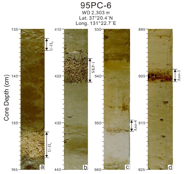
동해에서 채취된 해저퇴적물과 일본 긴끼(Kinki) 지역 도리하마(Torihama)에서 울릉도 화산의 약 9,300년 전 플리니식 분화로 이동 퇴적된 울릉-오키(Ulleung-Oki; U-Oki) 테프라가 보고되었다(그림 1; Machida and Arai, 1983; Furuta et al., 1986; Machida, 1999). 이후 동해 울릉분지(Ulleung Basin)에서 채취된 시추코어의 테프라 분석으로 울릉도 화산의 플리니식 분화 역사가 더 자세히 밝혀졌다(그림 1; Chun et al., 1997a, 1998; Chun, 2000). 울릉도 화산의 플리니식 분화는 울릉-III (Ulleung-III; 약 16,500년 전), 울릉-IIL (Ulleung-IIL; 약 9,300년 전), 울릉-IIU (Ulleung-IIU), 울릉-I (Ulleung-I; 약 5,600년 전) 테프라층에 의해 밝혀졌다(Chun, 2000). 울릉-III 테프라는 최후최대빙하기(Last Glacial Maximum; LGM) 시기에 퇴적된 질량류와 반원양성 교호 퇴적층 내에 포함되어 있다(Chun, 2000). 울릉-II 테프라의 경우는 하부(울릉-IIL)와 상부 (울릉-IIU) 구간으로 구분되는데(그림 2a), 울릉-IIL 테프라는 울릉-IIU 테프라에 비하여 다량의 암편이 포함된 특성을 보이고 울릉-오키(U-Oki; 약 9,300년 전) 테프라와 대비된다(Chun et al., 1997b; Shiihara et al., 2011). 울릉-IIU 테프라의 분화 시기는 울릉분지 시추코어에서 분석되지 않았지만, 본 연구에서는 야마토분지에서 채취된 시추코어에서 약 8,400년 전 울릉도 화산의 플리니식 분화로 기원된 TRG1 테프라와 대비시켰다(Shiihara et al., 2011). 울릉-I 테프라는 시추코어에서 대부분 층리가 발달되지 않고 부석들이 산재되어 나타나는데, 이것은 해저면에 퇴적된 이후에 저서생물의 생물교란작용에 의한 것으로 해석되었다(Chun et al., 1997a, 1998; Chun, 2000). 시추코어에서 울릉-I 테프라의 분포 구간이 생물교란에 의해서 넓게 나타나는데, 이것은 시추코어 간의 시간층서대비에 어려움을 준다(Chun, 2000). 일반적으로 해저 테프라층서 연구는 육안으로 확인되고, 재동 또는 저서생물에 의해서 교란이 일어나지 않은 시료를 대상으로 하지만, 화산의 플리니식 분화 역사 복원을 위해서는 육안으로 확인되지 않는 크립토테프라(cryptotephra)를 분석하기도 한다(Lim et al., 2008; Lowe, 2011). 일본 큐슈 최남단에 위치하는 기카이 칼데라에서 약 6,300년 전 플리니식 분화로 동해로 이동된 기카이-아카호야(Kikai-Akahoya; K-Ah) 테프라는 동해 울릉분지에서 육안으로 확인되지 않지만, 시추코어 퇴적물의 중성자 활성화 분석(Instrumental Neutron Activation Analysis; INNA)을 통해서 확인되었다(Lim et al., 2008). 최근 울릉도 화산에서 각 시기별 화산쇄설성 퇴적층 연구가 활발히 이루어졌는데(Kim et al., 2014; Hwang et al., 2021), 울릉도 화산의 최후 화산 활동이 3,070~3,275년 전에 있었음이 밝혀졌다(Chun and Lee, 2019). 울릉도 화산으로부터 남동쪽으로 약 500 km 떨어진 일본 혼슈의 스이게츠호수(Lake Suigetsu)에서 채취된 SG14 시추코어에서는 크립토테프라 분석으로 울릉도 화산의 플리니식 분화로 장거리 이동된 테프라 4 매(2,620~2,737년 전, 5,619~5,681년 전, 8,367~8,455년 전, 10,171~10,230년 전)가 확인되었다(McLean et al., 2018). 최근 새로이 채취된 시추코어와 관련 연구 결과들을 종합하여 울릉도 화산의 플리니식 분화 역사에 대한 재정립이 필요하다.
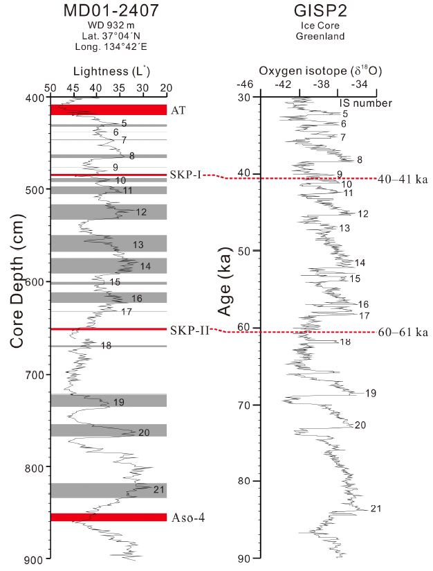
동해 야마토분지(Yamato Basin)에서 채취된 시추코어에서 처음 보고된 울릉-야마토(Ulleung-Yamato; U-Ym) 또는 야마토(Yamato; Ym) 테프라는 울릉도 화산의 약 30,000-50,000년 전 플리니식 분화로 퇴적된 것으로 보고되었다(Machida and Arai, 1983; Nakajima et al., 1996). 동해 울릉분지에서 채취된 시추코어에서는 해당 구간 테프라의 입도, 기공, 층후, 지화학 특성을 분석하여 한국대지(South Korea Plateau; SKP) 남측에 위치하는 SKP 해저화산의 40,000~41,000년 전 폭발적인 분화로 퇴적된 SKP-I 테프라로 재해석되었다(Chun et al., 2007). 그리고 약 60,000~61,000년 전 해저화산의 폭발적인 분화로 퇴적된 SKP-II 테프라도 함께 발견되었다(Chun et al., 2007; Um et al., 2017). 한국대지에서 획득한 자기이상(magnetic anomaly) 자료와 천부탄성파(sub-bottom seismic profile) 자료에 의해서 추정된 SKP 해저화산의 위치는 한국대지 남측 수심 약 1,050 m 지역이만, SKP 해저화산에 대한 정밀조사는 실시되지 않았다(Chun, 2000). SKP-I과 SKP-II 테프라는 조립질 부석과 세립질 암편 또는 광물들로 구성되어 이중모드(bimodal) 입도분포를 보이는데(그림 2b, 3), 이것은 SKP 해저화산의 분연주가 대기로 나가지 못하고 해수면에 도달하여 횡적으로 이동했기 때문이며 이때 해수 중의 부석과 암편(또는 광물)의 밀도 차이가 크지 않아서 거의 동시에 해저면에 낙하되어 이중모드 입도 특성이 나타난다(Cashman and Fiske, 1991). 이와 대조적으로 울릉도 화산의 플리니식 분화로 이동된 테프라들은 단모드(unimodal) 입도 특성을 보이는데, 이것은 대기에서 이동될 때 부석과 암편(또는 광물)의 상대적인 큰 밀도 차이로 일차적인 분급이 일어나고, 그 후에 해수로 낙하되어 이차적인 분급이 일어나서 단모드로 나타나는 것이다(Cashman and Fiske, 1991; Chun et al., 1998). SKP 해저화산 기원 테프라는 총알카리와 실리카 함량(total alkali/silica; TAS) 도표에서 울릉도 화산 기원 테프라와 거의 유사한 포노라이트(phonolite) 또는 조면암(trachyte) 영역에 표시되는데, 테프라의 지화학 특성에 의한 SKP 해저화산과 울릉도 화산의 분류는 어렵다(그림 4; Chun et al., 1997a, 1998, 2007; Chun, 2000). 울릉도 화산기원 테프라의 기공(vesicle)은 한 방향으로 신장되어 있고 기공사이의 벽이 얇다(그림 5a). SKP 해저화산 기원 테프라의 기공은 방향성이 없으며, 기공사이의 벽이 상대적으로 두껍게 발달되어 있다(그림 5b). 이러한 SKP 해저화산 기원 테프라의 기공 특성은 수심 약 1,050 m에서 화산 분화가 일어날 때 높은 수압에 의한 영향에 의한 것으로 해석되었다(Chun et al., 2007). 동해에서는 그린랜드 빙하코어에서 보고된 지난 25만년 동안의 단스고르-외쉬거(Dansgaard-Oeschger; D-O) 고기후 변동 기록인 간극기(Stadial)과 아간극기(Interstadial; IS)에 대비되는 담색과 암색의 교호층이 잘 발달되어 있다(Dansgaard et al., 1993; Nakajima et al., 1996; Tada et al., 1999). 동해 시추코어에서는 아간극기의 발달 순서에 의해서 SKP-I(IS 9와 IS 10 사이)과 SKP-II(IS 17과 IS 18 사이) 테프라의 분화 시기가 밝혀졌다(그림 6; Chun et al., 2007). 일본 혼슈의 스이게츠호수에서 채취된 SG93과 SG06 시추코어에서는 아이라-탄자와(Aira-Tanzawa; AT, 약 29,000년 전) 테프라와 아소-4(Aso-4; 약 88,000년 전) 테프라 사이에서 포노라이트 또는 조면암 마그마 성분의 테프라가 발견되지 않았는데(Maruyama et al., 2019), 이것은 울릉도 기원 테프라와 달리 SKP 테프라가 대기로 이동하지 않았다는 증거이다.
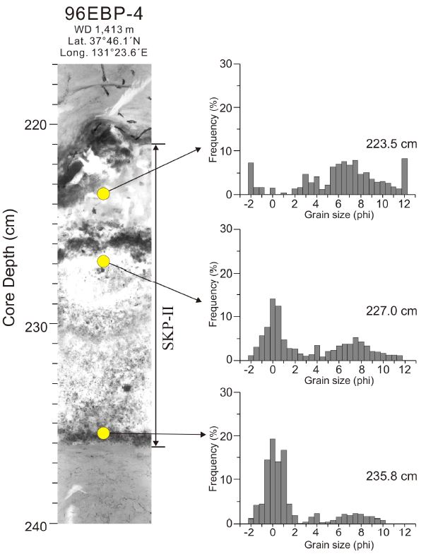
X-radiograph showing the SKP-II tephra in marine cores from the Ulleung Basin, East Sea. Grain-size histograms of the SKP-II tephra are shown for bimodal (modified from Chun et al., 2007).
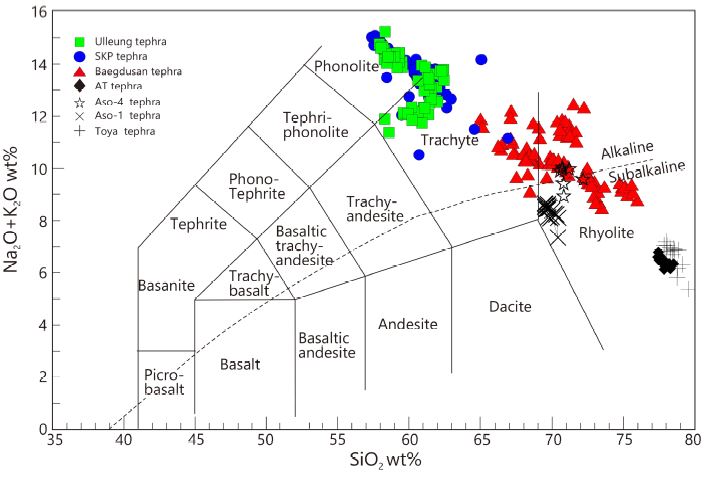
Total alkalis versus silica (TAS) diagram of tephra layers from the East Sea sediments. Ulleung tephra (Ulleung-I, Ulleung-IIU, and Ulleung-IIL tephras; Chun et al., 1997a, 1998), SKP tephra (SKP-I and SKP-II tephra; Chun et al., 2007), AT tephra (Chun et al., 1997a), Aso-4 tephra (Chun et al., 1998), Baegdusan tephra (B-Tm, B-J, B-Sado, B-Ym, B-KY1, B-KY2, and B-Og tephras; Chun and Cheong, 2000), and Aso-1 and Toya tephras (Chun and Cheong, 2020).
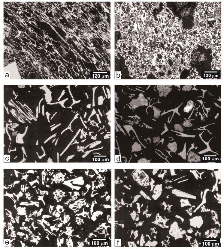
Backscattered electron images (BSEI) of tephra layers in marine core from the East Sea. (a) U-IIL tephra (Chun et al., 2007), (b) SKP-I tephra (Chun et al., 2007), (c) AT tephra (Chun et al., 2006a), (d) Aso-1 tephra (Chun and Cheong, 2020), (e) B-J tephra (Chun et al., 2006b), (f) B-KY1 tephra (Chun et al., 2006a).
백두산 화산에서 10세기에 발생된 플리니식 분화(VEI 7)로 백두산-토마코마이(Baegdusan-Tomakomai; B-Tm) 테프라가 동해 해양 퇴적분지와 홋카이도 육상에서 보고되었다(Machida and Arai, 1983; Furuta et al., 1986; Machida, 1999). 최근 북위 35도 35분에 위치하는 혼슈 스이게츠호수에서 채취된 SG06 시추코어에서도 B-Tm(약 940~950 CE) 테프라가 보고되었다(McLean et al., 2016). 10세기에 발생된 백두산 플리니식 분화와 관련된 화쇄류(pyroclastic density currents; PDC) 수치모델 연구와 화산 분화 예측 연구 등이 이루어졌지만(Chang and Yun, 2015; Hong et al., 2016), 10세기 이전에 발생된 백두산 화산의 플리니식 분화 역사에 대한 연구는 잘 알려져 있지 않다. 지금까지 동해 해저 테프라층서 연구에 의해서 밝혀진 백두산 화산의 플리니식 분화는 약 44만 8천년 전부터 약 940~950 CE 기간 동안에 최소 8차례 이상 으로 분석되었다(Chun and Cheong, 2020). 백두산에서 조면안산암질 또는 조면암질 용암이 분출된 약 149만년 전 이후부터 플리니식 분화의 가능성은 점차적으로 증가하였으며, 최소 약 448,000년 전에는 백두산-오가(Baegdusan-Oga; B-Og) 테프라가 분화되었다(Chun and Cheong, 2020). 백두산-일본분지(Baegdusan-Japan Basin; B-J) 테프라의 분화 시기는 해저퇴적층에 보존된 전 지구적 고기후 변동기록인 아간극기 14 (IS 14) 구간에 해당되는 51,500년 전으로 재해석되었다(Chun et al., 2006b). 동해 시추코어에서 B-J 테프라의 확산 범위는 B-Tm 테프라에 비해서 남측으로 치우쳤는데, 이것은 B-J 테프라의 분화 당시 제트류 특성이 현재 겨울철 제트류 특성과 유사했음을 지시한다(Chun et al., 2006b). 동해 키타-야마토해곡(Kita-Yamato Trough)의 북위 약 39도에서 채취된 시추코어에서는 SKP-I과 SKP-II 테프라 이외의 또 다른 SKP 해저화산 기원 테프라들이 발견되었지만, 울릉도 화산 기원 테프라는 전혀 발견되지 않았다(Chun et al., 2006a). 이 시추코어에서 처음으로 보고되는 백두산-키타야마토 1(Baegdusan-Kita Yamato 1; B-KY1, 약 135,000년 전)과 백두산-키타야마토 2(B-KY2, 약 196,000년 전) 테프라가 발견되었다(Chun et al., 2006a; Chun and Cheong, 2020). 이 결과들은 동해 북위 약 39도 부근이 육안으로 확인되는 울릉도 화산 기원 테프라의 북방한계선이며, 백두산 화산 기원 테프라의 남방한계선으로 해석된다. B-J 테프라와 B-KY1 테프라는 미세 부석(micropumice), 유리질 샤드(glass shard), 광물들로 구성되어 있으며, 일본 큐슈 지역 화산들로부터 이동 퇴적된 테프라와는 입자 구성과 형태가 뚜렷이 구별된다(그림 5).
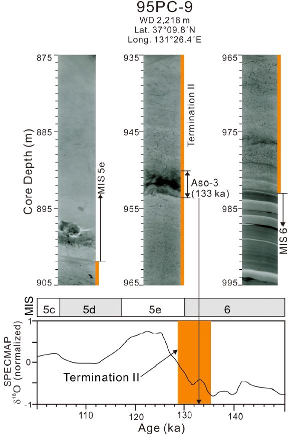
동해에서 채취된 시추코어에서는 일본 큐슈 지역 화산들의 플리니식 분화로 이동 퇴적된 K-Ah, AT, Aso-4, Ata, Aso-3, Aso-1 테프라 등이 보고되었다(Machida and Arai, 1983; Furuta et al., 1986; Chun et al., 1997a, 1998, 2004, 2006a, 2006b, 2007; Machida, 1999; Park et al., 2003; Lim et al., 2008; Um et al., 2017; Chun and Cheong, 2020). 이중에서 일본 큐슈 아소(Aso) 칼데라의 화쇄류에 동반된(co-ignimbrite) 플리니식 분화로 퇴적된 Aso-3 테프라는 일본 연구자들의 핵분열 비적 연대측정(Fission track dating; FT, 약 103,000년 전), 열루미네선스 연대측정(Thermoluminescent dating:TL, 약 110,000년 전), 포타슘-아르곤 연대측정(Potassium-argon; K-Ar, 약 123,000년 전), 북서 태평양의 해저퇴적물과 해안단구 퇴적층 분석에 의해서 해양동위원소 5d(Marine Isotope Stage 5d; MIS 5d) 등으로 다양한 분화시기가 보고되었다(Okaguchi, 1978; Machida and Arai, 1994; Machida, 1999). 동해 울릉분지 시추코어에서 발견된 Aso-3 테프라는 간빙기와 해빙기 사이의 두번째 해빙기 퇴적상(penulti-mate deglaciation or Termination II)에 위치하며, 분화시기는 약 133,000년 전(MIS 6)으로 분석되었다(그림 7; Chun et al., 2004). 최근 일본 혼슈 스이게츠호수에서 채취된 SG93과 SG06 시추코어의 고해상력 연대 분석에서도 Aso-3 테프라의 분화시기가 133,000년 전으로 계산되었다(Maruyama et al., 2019).
2.2 향후 한반도 주변 화산의 플리니식 분화 연구 방향
동해 해양 퇴적분지에서는 국제해저지각시추프로그램(Integrated Ocean Drilling Program Expedition 346; IODP Exp. 346)에서 북위 43도 45분에서 35도 57분까지 7개의 시추코어가 채취되었다(그림 8; Tada et al., 2015). 시추코어의 채취 지점에 따라서 테프라 분포의 차이가 크며, 한국대지에서 채취된 U1430A 시추코어에서는 대부분의 테프라가 플라이스토세 퇴적물에 협재되어 있다(그림 8; Tada et al., 2015). 다른 지역에서 채취된 시추코어에서도 플라이스토세 기간에 협재된 테프라의 빈도수가 우세하지만, 플라이오세(Pliocene; 2.58-5.33 Ma)와 마이오세(Miocene; >5.33 Ma) 기간에도 테프라의 협재가 관찰된다(그림 8; Tada et al., 2015). 이 시추코어들에 협재된 테프라의 층서적 위치는 선상에서 분석된 것으로 화산성 또는 재동 여부가 확인되지 않은 것이다(Tada et al., 2015). 향후 IODP Exp. 346 시추코어에 협재된 테프라를 연구하기 위해서는 테프라층과 상하부 퇴적상 분석을 통한 시료 채취 구간 결정, 지화학 성분과 구성입자 분석에 의한 기원화산 해석, 다양한 연대측정(산소동위원소, 고지자기연대, 생층서, 포타슘-아르곤 연대측정, 고기후 변동에 따른 퇴적상 분석)에 의한 분화 시기 해석 등이 필요하다. 동해 울릉분지에서도 가스하이드레이트 사업에서 다수의 시추코어가 채취되었고, 일부 시추코어에서 테프라층서 연구가 이루어졌지만 아직도 충분하지 않다(Um et al., 2017). 기존 연구에서는 울릉도 화산의 플리니식 분화로 이동된 테프라가 대부분 울릉도 동측으로 이동된 것으로 해석되었는데(Machida and Arai, 1983; Furuta et al., 1986; Machida, 1999), 울릉분지 서측 대륙사면에서도 울릉도 화산 기원의 테프라가 보고되면서 분포 범위에 대한 재해석이 필요하다(Um et al., 2017; Cukur et al., 2020). 백두산 화산의 플리니식 분화 가 언제 시작되었으며, 얼마나 자주 발생되었으며, 백두산 화산체에서의 용암 분출 역사와는 어떤 관련이 있는지에 대한 자세한 연구도 필요하다.
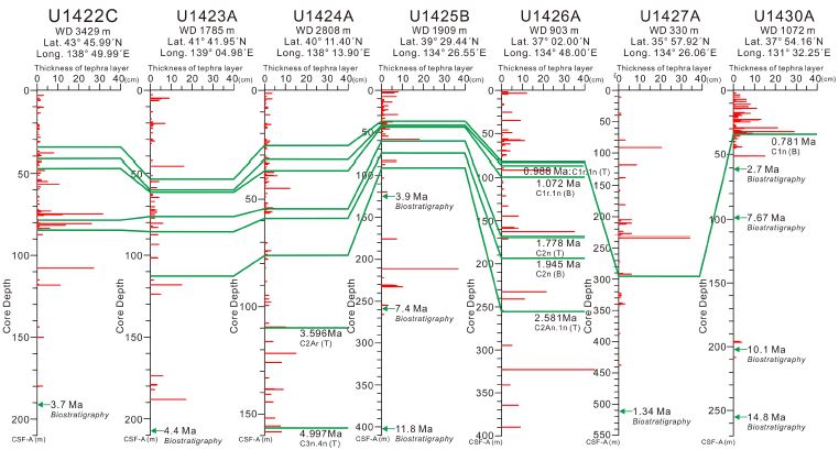
Visible tephra layers (> 0.5 cm thick) in the East Sea sediments of Integrated Ocean Drilling Program (IODP) Exp. 363 cores (data from Tada et al., 2015). Red thick lines indicate the thickness of tephra layers. Green thick lines indicate polarity chron events. Green arrows denote biostratigraphic events.
동해 한국대지에 위치하는 것으로 추정되는 SKP 해저화산체에 대한 연구는 거의 이루어지지 않았는데, 추정되는 지역에서 탄성파 탐사 자료, 해저면 영상 자료, 시료 채취 및 분석이 필요하다. 2022년 1월 15일 남서태평양 통가열도 Hunga (또는 Hunga Tonga-Hunga Háapai) 화산의 플리니식 분화(VEI 5-6)로 2014~2015년 분화에 의해서 형성된 응회구(tuff cone) 대부분이 사면사태로 무너졌는데, 화산분화에 의한 해수 변위(eruption-induced water displacement)와 압력에 의한 지구규모의 지진파(pressure-induced planetary-scale waves) 등에 의해서 발생된 지진해일(tsunami)이 남서태평양 전 역에 큰 피해를 입혔다(Brenna et al., 2022; Heidarzadeh et al., 2022; Yuen et al., 2022). 동해 해저화산의 폭발적인 분화는 해수면에서 테프라의 이동 확산이 일어나서 플리니식 화산 분화로 분류되지는 않지만, 해저화산의 폭발적인 분화에 의한 사면사태 또는 지진해일의 발생 가능성, 테프라 이동 확산에 의한 선박 운항에 피해, 해저면 저서생물의 영향 등에 대한 연구도 필요하다.
일본 큐슈 지역 화산들의 플리니식 분화로 다수의 테프라(K-Ah, AT, Aso-4 등)가 우리나라 육상으로 이동 퇴적된것으로 보고되었다(Machida et al., 1999). 지금까지 우리나라 육상에서 확인된 테프라는 AT와 Ata 테프라이며(Yi et al., 1998; Lim et al., 2006; Kim et al., 2021), 향후 후속연구에 의해서 추가적으로 발견될 가능성은 크다. 최근 우리나라 육상에서 채취된 호수퇴적물 시추코어에서 잘 보존된 플라이스토세 퇴적층이 보고되었는데(Lim et al., 2021), 이 시추코어에서 고해상도 테프라층서 연구가 수행될 경우 일본 큐슈 지역 화산들의 플리니식 분화 역사 복원과 육상 시추코어 간의 시간층서대비 연구에 도움을 줄 것이다.
3. 결 론
동해 해양 퇴적분지에서의 해저 테프라층서 연구는 한반도 주변 화산들의 플리니식 분화에 대한 자세한 정보를 제공하였다. 동해 해저퇴적물에서 발견된 울릉도 화산 기원 테프라들은 후기 플라이스토세부터 홀로세 기간 동안에 플리니식 분화가 최소 4 차례 있었음을 지시하고, 테프라들이 울릉분지 서측 대륙사면까지 이동 퇴적된 것이 확인되었다. 한국대지에 위치하는 것으로 추정되는 SKP 해저화산의 폭발적인 분화는 주로 플라이스토세 기간 동안에 지속적으로 발생되었는데, 해저화산의 폭발적인 분화 역사와 해저 산사태 또는 지진해일의 발생 여부는 알려져 있지 않다. 백두산 화산의 플리니식 분화는 약 448,000년 전부터 약 940~950 CE까지 최소 8 차례가 확인되었고, 백두산 화산체에서 조면암질 용암의 분출 이후에 플리니식 분화의 최초 시점과 플리니식 분화 역사 복원에 대한 연구가 필요하다. 앞으로 동해 퇴적분지에서 채취된 IODP 시추코어와 육상 시추코어에 협재된 테프라의 고해상력 연구는 후기 마이오세 이후의 한반도 주변 백두산, 울릉도, SKP 해저화산, 일본열도 화산들의 플리니식 분화 역사 복원에 큰 도움이 될 것이다. 과거 한반도 주변 화산들의 플리니식 분화 역사의 복원은 향후 플리니식 화산 분화의 예측 및 관측에 필요한 정보를 제공할 것이다.
Acknowledgments
본 연구는 한국지질자원연구원에서 수행한 “한반도 활화산 특성평가 및 화산 감시 기반기술 개발(22-3122)” 사업의 지원으로 수행되었다. 이 논문의 심사과정에서 유익한 의견을 주신 편집위원과 심사위원들께 감사드린다.
References
-
Brenna, M., Cronin, S.J., Smith, I.E.M., Pontesilli, A., Tost, M., Barker, S., Tonga’onevai, S., Kula, T. and Vaiomounga, R., 2022, Post-caldera volcanism reveals shallow priming of an intra-ocean arc andesitic caldera: Hunga volcano, Toga, SW Pacific. Lithos, 412-413, 106614.
[https://doi.org/10.1016/j.lithos.2022.106614]

-
Carey, S., Sigurdsson, H., Gardner, J.E. and Criswell, W., 1990, Variations in column height and magma discharge during the May 18, 1980 eruption of Mount St. Helens. Journal of Volcanology and Geothermal Research, 43, 99-112.
[https://doi.org/10.1016/0377-0273(90)90047-J]

-
Casadevall, T.J., 1994, The 1989-1990 eruption of Redoubt Volcano, Alaska: impacts on aircraft operations. Journal of Volcanology and Geothermal Research, 62, 301-316.
[https://doi.org/10.1016/0377-0273(94)90038-8]

-
Cashman, K.V. and Fiske, R.S., 1991, Fallout of pyroclastic debris submarine volcanic eruptions. Sciences, 253, 275-280.
[https://doi.org/10.1126/science.253.5017.275]

-
Chang, S. and Yun, S.-H., 2015, Numerical simulation using VolcFlow for pyroclastic density currents by explosive eruption of Mt. Baekdu. Journal of the Geological Society of Korea, 51, 363-375 (in Korean with English abstract).
[https://doi.org/10.14770/jgsk.2015.51.4.363]

- Chun, J.-H., 2000, Late Pleistocene to Holocene tephrostratigraphy and paleoenvironment of the Ulleung Basin in the East Sea, Korea. Ph.D. thesis, Kangwon National University, Chuncheon, 283 p.
-
Chun, J.-H. and Cheong, D., 2020, Origin of compositional diversity of marine tephra during the Late Middle Pleistocene B-KY1 Baekdusan volcanic eruption. Applied Sciences, 10, 4469.
[https://doi.org/10.3390/app10134469]

- Chun, J.-H., Cheong, D., Han, S.-J., Huh, S. and Yoo, H.-S., 2006a, Tephrostratigraphy and paleoenvironments of marine core in the Kita-Yamato Trough, East Sea/Japan Sea. Economic and Environmental Geology, 39, 83-93 (in Korean with English abstract).
-
Chun, J.-H., Cheong, D., Ikehara, K. and Han, S.-J., 2007, Age of the SKP-I and SKP-II tephras from the southern East Sea/Japan Sea: Implications for interstadial events recorded in sediment from marine isotope stages 3 and 4. Palaeogeography, Palaeoclimatology, Palaeoecology, 247, 100-114.
[https://doi.org/10.1016/j.palaeo.2006.11.024]

- Chun, J.-H., Cheong, D., Lee, Y.-J., Kwon, Y.-I. and Kim, B.-C., 2006b, Stratigraphic implications as a time marker of the B-J tephra erupted from Baegdusan volcano discovered in the marine cores of the East Sea/Japan Sea during the late Pleistocene. Journal of the Geological Society of Korea, 42, 31-42 (in Korean with English abstract).
-
Chun, J.-H., Han, S.-J. and Cheong, D., 1997a, Tephrostratigraphy in the Ulleung Basin, East Sea: Late Pleistocene to Holocene. Geoscience Journal, 1, 154-166.
[https://doi.org/10.1007/BF02910207]

- Chun, J.-H., Han, S.-J., Cheong, D., Huh, S., Bahk, J.-J. and Choi, D.-L., 1998, Tephrostratigraphy of deep-sea sediments around submarine channels, northeastern Ulleung Basin. Journal of the Geological Society of Korea, 34, 192-210 (in Korean with English abstract).
- Chun, J.-H., Han, S.-J., Cheong, D., Huh, S. and Shin, D.-H., 1997b, Volcanic processes of the Ulleung-II tephra (Ulleung-Oki ash) erupted from the Ulleung Island. Ocean Research, 19, 275-283.
-
Chun, J.-H., Ikehara, K. and Han, S.-J., 2004, Evidence in Ulleung Basin sediment cores for a Termination II (Penultimate deglaciation) eruption of the Aso-3 tephra. The Quaternary Research (Daiyonki-kenkyu), 43, 99-112.
[https://doi.org/10.4116/jaqua.43.99]

-
Chun, J.-H. and Lee, H.-J., 2019, Subaerial and subaqueous investigations of volcanic debris avalanche and lahar deposits on the northern coast of Ulleung Island, Korea. Journal of Coastal Research, 90, 369-376.
[https://doi.org/10.2112/SI90-047.1]

-
Criswell, C.W., 2021, A revised narrative of the May 18, 1980 Plinian eruption of Mount St. Helens: Changes in the conduit and magma supply. Journal of Volcanology and Geothermal Research, 419, 107388.
[https://doi.org/10.1016/j.jvolgeores.2021.107388]

-
Cukur, D., Um, I.-K., Chun, J.-H., Lee, G.-S., Kim, S.-R., Bahk, J.-J., Urgeles, R. and Horozal, S., 2020, Factors leading to slope failure on a sediment-starved margin: The southwestern continental margin of the East Sea, Korea. Marine Geology, 428, 106282.
[https://doi.org/10.1016/j.margeo.2020.106282]

-
Dansgaard, W., Johnsen, S.J., Clausen, H.B., Dahl-Jensen, D., Gundestrup, N.S., Hammer, C.U., Hvidberg, C.S., Steffensen, J.P., Sveinbjörnsdottir, A.E., Jouzel, J. and Bond G., 1993, Evidence for general instability of past climate from a 250-kyr ice-core record. Nature, 364, 218-220.
[https://doi.org/10.1038/364218a0]

-
Doronzo, D.M., Di Vito, M.A., Arienzo, I., Bini, M., Calusi, B., Cerminara, M., Corradini, S., De Vita, S., Giaccio, B., Gurioli, L., Mannella, G., Ricciardi, G.P., Rucco, I., Sparice, D., Todesco, M., Trasatti, E. and Zanchetta, G., 2022, The 79 CE eruption of Vesuvius: A lesson from the past and the need of a multidisciplinary approach for developments in volcanology. Earth-Science Reviews, 231, 104072.
[https://doi.org/10.1016/j.earscirev.2022.104072]

-
Evans, W.C., Bergfeld, D., McGimsey, R.G. and Hunt, A.G., 2009, Diffuse gas emissions at the Ukinrek Maars, Alaska: Implications for magmatic degassing and volcanic monitoring. Applied Geochemistry, 24, 527-535.
[https://doi.org/10.1016/j.apgeochem.2008.12.007]

-
Fero, J., Carey, S.N. and Merrill, J.T., 2009, Simulating the dispersal of tephra from the 1991 Pinatubo eruption: Implications for the formation of widespread ash layers. Journal of Volcanology and Geothermal Research, 186, 120-131.
[https://doi.org/10.1016/j.jvolgeores.2009.03.011]

-
Furuta, T., Fujioka, K. and Arai, F., 1986, Widespread submarine tephra around Japan-petrographic and chemical properties. Marine Geology, 72, 125-142.
[https://doi.org/10.1016/0025-3227(86)90103-9]

-
Guffanti, M., Ewert, J.W., Gallina, G.M., Bluth, G.J.S. and Swanson, G.L., 2005, Volcanic-ash hazard to aviation during the 2003-2004 eruptive activity of Anatahan volcano, Commonwealth of the Northern Mariana Islands. Journal of Volcanology and Geothermal Research, 146, 241-255.
[https://doi.org/10.1016/j.jvolgeores.2004.12.011]

-
Heidarzadeh, M., Gusman, A.R., Ishibe, T., Sabeti, R. and Šepić, J., 2022, Estimating the eruption-induced water displacement source of the 15 January 2022 Tonga volcanic tsunami from tsunami spectra and numerical modelling. Ocean Engineering, 261, 112165.
[https://doi.org/10.1016/j.oceaneng.2022.112165]

-
Hong, T.-K., Choi, E., Park, S. and Shin, J.S., 2016, Prediction of ground motion and dynamic stress change in Baekdusan (Changbaishan) volcano caused by a North Korean nuclear explosion. Scientific Reports, 6, 21477.
[https://doi.org/10.1038/srep21477]

-
Huang, T.C., Watknis, N.D., Shaw, D.M. and Kennett, J.P., 1973, Atomospherically transported volcanic dust in south Pacific deep sea sedimentary cores at distances over 3000 km from the eruptive source. Earth and Planetary Science Letters, 20, 119-124.
[https://doi.org/10.1016/0012-821X(73)90148-9]

-
Hwang, S.K., Lee, S.J., Ryu, H.Y. and Jang, Y.D., 2021, 40Ar/39Ar dating and inferences about plumbing system in Nari Caldera, Ulleung Island, Korea. Journal of the Geological Society of Korea, 57, 679-690 (in Korean with English abstract).
[https://doi.org/10.14770/jgsk.2021.57.5.679]

-
Kandlbauer, J. and Sparks, R.S.J., 2014, New estimates of the 1815 Tambora eruption volume. Journal of Volcanology and Geothermal Research, 286, 93-100.
[https://doi.org/10.1016/j.jvolgeores.2014.08.020]

-
Kennett, J.P. and Huddlestun, P., 1972, Late Pleistocene paleoclimatology, foraminiferal biostratigraphy and tephrochronology, western Gulf of Mexico. Quaternary Research, 2, 38-69.
[https://doi.org/10.1016/0033-5894(72)90004-X]

-
Kim, C.-B., Kim, Y.-S. and Lim, H.S., 2021, Occurrence and identification of tephra layers found in the Ulsan area, Southeastern Korea. Journal of Korean Earth Science Society, 42, 55-64 (in Korean with English abstract).
[https://doi.org/10.5467/JKESS.2021.42.1.55]

-
Kim, G.B., Cronin, S.J., Yoon, W.S. and Sohn, Y.K., 2014, Post 19 ka B.P. eruptive history of Ulleung Island, Korea, inferred from an intra-caldera pyroclastic sequence. Bulletin of Volcanology, 76, 802.
[https://doi.org/10.1007/s00445-014-0802-1]

-
Lim, C., Ikehara, K. and Toyoda, K., 2008, Cryptotephra detection using high-resolution trace-element analysis of Holocene marine sediments, southwest Japan. Geochimica et Cosmochimica Acta, 72, 5022-5036.
[https://doi.org/10.1016/j.gca.2008.07.021]

- Lim, H.S., Nam, Y.J., Lee, Y.I., Kim, C.-B., Yi, S., Chung, C.-H., Lee, H.-J. and Yoon, H.I., 2006, Principles and applications of tephrochronology: widespread AT (Aira-Tanzawa) tephra found in the Korean Peninsula. Journal of the Geological Society of Korea, 42, 645-656 (in Korean with English abstract).
-
Lim, J., Hong, S.-S., Han, M., Yi, S. and Kim, S.W., 2021, First finding of impact cratering in the Korean Peninsula. Gondwana Research, 91, 121-128.
[https://doi.org/10.1016/j.gr.2020.12.004]

-
Lowe, D.J., 2011, Tephrochronology and its application: A review. Quaternary Geochronology, 6, 107-153.
[https://doi.org/10.1016/j.quageo.2010.08.003]

-
Machida, H., 1999, The stratigraphy, chronology and distribution of distal marker-tephras in and around Japan. Global and Planetary Change, 21, 71-94.
[https://doi.org/10.1016/S0921-8181(99)00008-9]

-
Machida, H. and Arai, F. 1983, Extensive ash falls in and around the Sea of Japan from large Late Quaternary eruptions. Journal of Volcanology and Geothermal Research, 18, 151-164.
[https://doi.org/10.1016/0377-0273(83)90007-0]

-
Machida, H. and Arai, F., 1994, Implications of the time-marker Aso-3 tephra to the significant lowering of sea level in the marine isotope stage 5d. Journal of Geography (Japan), 103, 749-759 (in Japanese with English abstract).
[https://doi.org/10.5026/jgeography.103.7_749]

-
Maruyama, S., Takemura, K., Hirata, T., Yamashita, T. and Danhara, T., 2019, Petrographic properties of visible tephra layers in SG93 and SG06 drill core samples from Lake Suigetsu, central Japan. Journal of Geography (Chigaku Zasshi), 128, 879-903 (in Japanese with English abstract).
[https://doi.org/10.5026/jgeography.128.879]

-
McLean, D., Albert, P.G., Nakagawa, T., Staff, R.A., Suzuki, T., Suigetsu 2016 Project Members and Smith, V.C., 2016, Identification of the Changbaishan ‘Millennium’ (B-Tm) eruption deposits in the Lake Suigetsu (SG06) sedimentary archive, Japan: Synchronisation of hemispheric-wide palaeoclimate archives. Quaternary Science Reviews, 150, 301-307.
[https://doi.org/10.1016/j.quascirev.2016.08.022]

-
McLean, D., Albert, P.G., Nakagawa, T., Suzuki, T., Staff, R.A., Yamada, K., Kitaba, I., Haraguchi, T., Kitagawa, J., SG14 Project Members and Smith, V.C., 2018, Integrating the Holocene tephrostratigraphy for East Asia using a high-resolution cryptotephra study from Lake Suigetsu (SG14 core), central Japan. Quaternary Science Reviews, 183, 36-58.
[https://doi.org/10.1016/j.quascirev.2017.12.013]

-
Nakajima, T., Kikkawa, K., Ikehara, K., Katayama, H., Kikawa, E., Joshima, M. and Seto, K., 1996, Marine sediments and late Quaternary stratigraphy in the southeastern part of the Japan Sea–concerning the timing of dark layer deposition. Journal of Geological Society of Japan, 102, 125-138.
[https://doi.org/10.5575/geosoc.102.125]

-
Newhall, C.G. and Self, S., 1982, The volcanic explosivity Index (VEI): An estimate of explosive magmitude for historical volcanism. Journal of Geophysical Research, 87, 1231-1238.
[https://doi.org/10.1029/JC087iC02p01231]

- Okaguchi, M., 1978, Fission track dating of the obsidians from pyroclastic flow deposits. Secondary Series Bulletin of the Volcanological Society of Japan, 23, 231-240 (in Japanese with English abstract).
-
Rampino, M.R. and Self, S., 1982, Historic eruptions of Tambora (1815), Krakatau (1883), and Agung (1963), their stratospheric aerosols, and climatic impact. Quaternary Research, 18, 127-143.
[https://doi.org/10.1016/0033-5894(82)90065-5]

-
Rampino, M.R. and Self, S., 1993, Climate-volcanism feedback and the Toba eruption of ~74,000 years ago. Quaternary Research, 40, 269-280.
[https://doi.org/10.1006/qres.1993.1081]

-
Self, S., Rampino, M.R. and Barbera, J.J., 1981, The possible effects of large 19th and 20th century volcanic eruptions on zonal and hemispheric surface temperatures. Journal of Volcanology and Geothermal Research, 11, 41-60.
[https://doi.org/10.1016/0377-0273(81)90074-3]

-
Shiihara, M., Torii, M., Okuno, M., Domitsu, H., Nakamura, T., Kim, K.-H., Moriwaki, H. and Oda, M., 2011, Revised stratigraphy of Holocene tephras on Ulleung Island, South Korea, and possible correlatives for the U-Oki tephra. Quaternary International, 246, 222-232.
[https://doi.org/10.1016/j.quaint.2011.08.030]

-
Sparks, R.S.J., 1986, The dimensions and dynamics of volcanic eruption columns. Bulletin of Volcanology, 48, 3-15.
[https://doi.org/10.1007/BF01073509]

-
Sparks, R.S.J., Brazier, S., Hunag, T.C. and Muerdter, D., 1983–1984, Sedimentology of the Minoan deep-sea tephra layer in the Aegean and Eastern Mediterranean. Marine Geology, 54, 131-167.
[https://doi.org/10.1016/0025-3227(83)90011-7]

-
Tada, R., Irino, T. and Koizumi, I., 1999, Land-ocean linkages over orbital and millennial timescales recorded in late Quaternary sediments of the Japan Sea. Paleoceanography, 14, 236-247.
[https://doi.org/10.1029/1998PA900016]

- Tada, R., Murray, R.W., Alvarez Zarikian, C.A. and the Expedition 346 Scientists, 2015, Proceedings of the Integrated Ocean Drilling Program, Volume 346: College Station, TX (Integrated Ocean Drilling Program).
-
Thorarinsson, S., 1981, Tephra studies and tephrochronology: a historical review with special reference to Iceland. In: Self, S., Sparks, R.S.J. (eds.), Tephra Studies. Reidel, Dordrecht, 1-12.
[https://doi.org/10.1007/978-94-009-8537-7_1]

-
Timmreck, C., Graf, H.-F., Zanchettin, D., Hagemann, S., Kleinen, T. and Krüger, K., 2012, Climate response to the Toba super-eruption: Regional changes. Quaternary International, 258, 30-44.
[https://doi.org/10.1016/j.quaint.2011.10.008]

-
Um, I.K., Choi, M.S., Bahk, J.-J. and Chun, J.-H., 2017, Provenance of late Quaternary sediments on the southwestern slope of the Ulleung Basin, East/Japan Sea. Quaternary International, 459, 153-164.
[https://doi.org/10.1016/j.quaint.2017.04.013]

-
Weinzierl, B., Sauer, D., Minikin, A., Reitebuch, O., Dahlkötter, F., Mayer, B., Emde, C., Tegen, I., Gasteiger, J., Petzold, A., Veira, A., Kueppers, U. and Schumann, U., 2012, On the visibility of airborne volcanic ash and mineral dust from the pilot’s perspective in flight. Physics and Chemistry of the Earth, 45-46, 87-102.
[https://doi.org/10.1016/j.pce.2012.04.003]

-
Werner, C., Christenson, B.W., Hagerty, M. and Britten, K., 2006, Variability of volcanic gas emissions during a crater lake heating cycle at Ruapehu Volcano, New Zealand. Journal of Volcanology and Geothermal Research, 154, 291-302.
[https://doi.org/10.1016/j.jvolgeores.2006.03.017]

-
Williams, M., 2012, The ~73 ka Toba super-eruption and its impact: History of a debate. Quaternary International, 258, 19-29.
[https://doi.org/10.1016/j.quaint.2011.08.025]

- Yi, S., Soda, T. and Arai, F., 1998, New discovery of Aira-Tn ash (AT) in Korea. Journal of the Korean Geographical Society, 33, 447-454.
-
Yuen, D.A., Scruggs, M.A., Spera, F.J., Zheng, Y., Hu, H., McNutt, S.R., Thompson, G., Mandli, K., Keller, B.R., Wei, S.S., Peng, Z., Zhou, Z., Mulargia, F. and Tanioka, Y., 2022, Under the surface: Pressure-induced planetary-scale waves, volcanic lightning, and gaseous clouds caused by the submarine eruptions of Hunga Tonga-Hunga Háapai volcano. Earthquake Research Advances, 2, 100134.
[https://doi.org/10.1016/j.eqrea.2022.100134]


