부안군 백악기 격포리층 내 연질퇴적변형구조: 산상, 고경사 복원 및 사태형성원인
초록
이 논문은 백악기 격포분지 닭이봉 지역의 흑색 이암 내 특정 층준에 연속적으로 발달하는 연질퇴적변형구조(폭 >200 m, 두께 <2 m)의 특징과 형성기작에 대한 연구결과이다. 분지 평원에서 발생한 저밀도 저탁류에 의해 퇴적된 흑색 이암 내에 발달하는 연질퇴적변형구조는 중력 주도 사태가 아주 완만한 경사면(<1°) 발생하였음을 지시한다. 연질퇴적변형구조는 습곡, 충상단층 및 정단층으로 구성되며, 조사지점(동쪽에서부터 서쪽으로 조사지점 1에서 3)에 따라 상이한 기하학적 특징을 보인다. 조사지점 1의 습곡은 변형된 층준의 중·상부(높이 1~2 m 구간)에서 집중적으로 발달하고 이에 수반된 단층들(충산단층과 정단층)이 나타나는 반면, 조사지점 2와 3은 층준 전체(두께 약 2 m)가 습곡 되어있고 단층들은 관찰되지 않는다. 습곡의 전향성은 조사지점 1과 2에서는 동쪽 방향인 반면, 조사지점 3은 다양하다. 습곡의 힌지와 축면의 방향이 분산된 점 그리고 다양한 전향 방향은 조사지역의 습곡이 비원통형 습곡임을 지시한다. 습곡 힌지 방위각과 익간각의 상호관계를 통해 유추된 고경사 방향은 동남동(120°)이며, 이는 기 격포분지의 퇴적중심지 방향(북 내지 북서 방향; Kim et al., 2003)과 반대인 분지 동편에 위치한 부안화산암쪽으로 향하고 있음을 보여준다. 이는 연질변형구조의 형성기작이 화산분출작용 동안 분지 바닥이 화산방향으로 경동되어 발생하는 화산기원 사태와 밀접한 관련이 있었음을 유추케 한다.
Abstract
This study aims at revealing the structural characteristics and triggering mechanism of the soft-sediment deformation (SSD; up to 2 m-thick) structures that occurred continuously (>200 m-wide) within the black mudstone strata in Dalgibong area of the Cretaceous Gyeokpo Basin (or Kyokpori Basin). The highly deformed black mudstones indicate that the deformation is generated by gravity-driven slumping on a basin plain environment with low gradient less than <1°. The SSD structures, consisting of fold, thrust and normal fault, show different geometric characteristics at three sites (site 1 to 3 from east to west). The folding at site 1 predominantly occurs in the middle to upper part (from 1 to 2 m-high) of the deformed layer together with syn-deformational faults (thrust and normal fault), whereas folding observed in the whole layer (up to 2 m-thick) at site 2 and 3 without the faults. Fold vergence at site 1 and 2 is toward east, but is variable at site 3. Scattered directions of the fold hinge and axial plane of the folds together with diverse vergence directions of the folds indicate that the folds can be classified into a non-cylindrical fold. The inferred paleoslope direction on the basis of the Fold Hinge Azimuth and Interlimb Angle Method (HIM) is ESE (120°), and it is toward the Buan Volcanics locating the east side of the Gyeokpo Basin and is inconsistent with paleoflow direction inferred from a previous study (north- to northwest-ward; Kim et al., 2003). This envisages that the triggering mechanism of the SSD is closely related to volcanogenic-slumping, which was caused by volcanic-ward tilting of the basin floor during and/or shortly after volcanic eruptions.
Keywords:
Gyeokpo Basin, Gyeokpori Formation, Soft-sediment deformation, paleoslope, Volcanic activity키워드:
격포분지, 격포리층, 연질퇴적변형구조, 고경사 복원, 화산분출작용1. 서 론
연질퇴적변형(soft-sediment deformation)구조는 퇴적 동시기 또는 퇴적 직후에 물 또는 습기를 함유한 미고결 퇴적물이 액상화 작용(liquefaction)과 유체화 작용(fluidization)에 의해 형성되며, 이러한 변형구조는 경사진 사면의 붕괴에 따른 사태(slump), 상위 퇴적층의 과하중(overloading), 지진 충격파에 따른 지층의 흔들림 그리고 거대 폭풍우(major tempests) 등의 다양한 작용에 의해 발생할 수 있다(Owen, 1996, 2003; Shiki et al., 2000; Montenat et al., 2007; Moretti and Sabato, 2007; Owen and Moretti, 2008; Alfaro et al., 2010; Alsop and Marco, 2011, 2012, 2013, 2014; Moretti and Ronchi, 2011a; Owen et al., 2011). 따라서 퇴적분지 내에서 연질퇴적변형구조의 감별 및 형성기작에 대한 해석은 퇴적 동시성 분지 구조운동(예, 지진에 따른 지층의 흔들림, 사태, 퇴적동시성 단층운동 등)과 극렬한 지질재해 사건(예, 지진, 쯔나미, 폭풍 등)을 인지할 수 있으며, 이는 분지 내 퇴적기작 및 분지의 진화사를 이해하는데 있어 중요한 정보를 제공해 준다(Owen et al., 2011 and references therein).
퇴적분지가 형성되는 동안 분지 내부 또는 가장자리에 발달한 단층들의 활동은 분지 내부에 수많은 지진을 야기 시키며, 이러한 지진에 수반된 지층의 흔들림 또는 지진기원 사태(seismogenic slump)는 다양한 연질퇴적변형구조를 분지충전물 내에 형성시킨다(Neuwerth et al., 2006; Alsop and Marco, 2011; Berra and Felletti, 2011; Ettensohn et al., 2011; Koç Taşgın, 2011; Koç Taşgın et al., 2011; Moretti and Ronchi, 2011b; Odonne et al., 2011; Owen and Moretti, 2011; Rossetti et al., 2011; Doughty et al., 2014). 퇴적분지가 형성되는 동안 분지 내부 또는 외부에서의 활발한 화산작용은 분지충전물의 퇴적작용 그리고 퇴적계 및 층서 발달에 주요한 영향을 줄 뿐만 아니라(Simith, 1987; Branney and Kokelaar, 2002; Kataoka, 2005; Manville et al., 2005), 화산분출에 수반된 지진은 상기 단층운동처럼 분지충전물 내에 연질퇴적변형구조를 형성시킬 수 있다. 또한 화산분출 동안에 비워진 마그마방은 마그마방 천장의 붕괴와 이에 수반된 많은 단층작용(주로 정단층)에 의해 화산 주변 지층은 화구쪽으로 수렴하는 지괴 경동(block tilting)이 발생하게 된다(Gottsmann and Martí, 2011 and references therein). 이러한 지괴 경동은 분지 내 퇴적물의 변형 또는 퇴적물의 유동에 중요한 역할을 할 수 있음에도 불구하고, 연질퇴적변형구조의 발달과 분지 주변 화산작용의 영향에 대한 연구는 미흡한 실정이다.
한반도 중서부에 위치한 백악기 격포분지는 북동-남서 주향방향의 좌수향 주향이동단층에 의해 형성된 호성 주향이동분지(lacustrine strike-slip basin)로 알려져 있다(Kim et al., 1995, 2003). 최근 부안지역의 정밀 지질도 작성 결과는 격포분지가 최대직경 약 20 km에 달하는 부안화산암의 서편 가장자리에 위치하고 있으며, 쇄설성퇴적암과 화산쇄설암으로 구성된 격포분지의 격포리층(Kim et al., 1995, 2003)은 부안화산암의 다양한 층서단위 또는 층(stratigraphic unit or formation) 중 하나에 포함되는 것으로 보고되었다(Koh et al., 2013). 이는 분지주변의 화산활동이 분지의 형성과 층서 발달에 직·간접적인 영향을 주었음을 유추케 한다. 격포분지 닭이봉의 흑색 이암층 내에는 최대 두께 약 2 m의 습곡구조가 주향방향으로 약 200 m 이상 연속적으로 분포하고 있으며, 이러한 이암 내 습곡구조는 아주 완만한 경사면(<1°)에서 발달한 중력 주도 사태(gravity-driven slump)에 의해 연질변성을 받았음을 지시한다(e.g., Alsop and Marco, 2013). 본 연구에서 측정된 이암 내 습곡 그리고 이와 동시에 발달한 충상단층 및 신장변형구조(정단층, 부딘)의 구조요소 분석결과는 이들이 서쪽에서 동쪽으로 작용한 전단력에 의해 형성됨을 지시하며, 이러한 변형구조의 방향성은 퇴적물이 남동쪽 방향으로 기울어진 고사면을 따라 유동하면서 변형구조를 형성한 것으로 해석된다. 따라서 이러한 사태가 기 격포리층 퇴적계의 발달 방향(북 내지 북서방향; Kim et al., 2003)과 반대 방향인 부안화산암으로 수렴하는 점은 격포분지의 연질퇴적변형작용이 부안화산암의 화산작용과 밀접한 연관이 있음을 유추케 한다. 본 논문에서는 격포분지 닭이봉의 이암층 내에 발달하는 연질변형구조의 산상과 변형구조특성의 기재 및 변형기작을 해석하고, 이를 통해 퇴적물이 유동한 고사면의 경사 방향을 복원하고자 한다. 이와 더불어 분지 내 사태를 야기 시킨 요인들에 대해 토의하고자 한다.
2. 지질개요
2.1 부안화산암과 격포분지 암상 특징
유라시아판 아래로 사각섭입하는 해양판(이자나기판)의 영향으로 인해(Klimetz, 1983; Engebretson et al., 1984; Watson et al., 1987; Kim et al., 1997) 백악기 한반도는 광범위한 좌수향 주향이동 구조운동과 함께 대륙성 화산호 활동(continental arc volcanism)이 활발하게 일어났으며, 그 결과 북동-남서 내지 북북동-남남서 주향방향의 좌수향 주향이동단층대(공주단층계, 광주단층계)를 따라 다양한 크기와 모양의 육성퇴적분지(nonmarine sedimentary basin)와 다량의 화강암류와 화산암류가 형성되었다(Kim et al., 2012; Chough, 2013 and references therein; 그림 1).
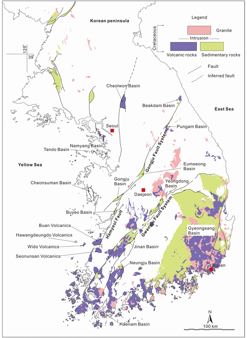
Distribution of Cretaceous sedimentary basins and plutonic-volcanic rocks along major fault systems in the southern part of the Korean Peninsula. Independent Cretaceous volcanic mountains occurred along the NE-SW-trending strike-slip fault, named Hamyeol Fault, in the mid-west Korea.
백악기 화산암류는 주로 북동-남서 주향방향의 좌수향 주향이동 단층대를 따라 그리고 경상분지 중앙에 넓게 분포하고 있으며, 특히 한반도 중서부(부안-법성포)에는 수 개의 화산암체가 좌수향 주향이동단층(함열단층)을 따라 타원형 내지 원형의 독립적인 산악지형을 형성하고 있다(그림 1). 최근 부안 지역에서의 지질도작성 결과는 각각의 화산암체가 다양한 화산암류와 퇴적암으로 이루어져 있으며, 독립적인 분포양상 및 서로 다른 암상 구성을 보이는 이들 화산암체를 크게 4개의 독립적인 화산암(부안화산암, 선운산화산암, 위도화산암, 하왕등도화산암)으로 구분하였다(Koh et al., 2013; 그림 1). 이들 중 가장 큰 규모의 부안화산암은 북동-남서 방향으로 최대직경과 북서-남동 방향으로의 최단직경이 각각 약 20 km와 10 km에 달한다(그림 2). Koh et al. (2013)은 부안화산암을 구성하고 있는 다양한 화산암류와 퇴적암에 대해서 암석 유형(표생쇄설암 대 화산쇄설암), 화산폭발 유형(폭발적 화산분출 대 비폭발적 화산분출), 입자크기, 구성하고 있는 광물과 암편의 조합, 산상 등을 근거로 총 9개의 층서단위(또는 층)으로 구분하고, 하위에서부터 천마산응회암, 우동제응회암, 석포응회암, 격포리층(Kim et al., 1995, 2003), 곰소유문암, 유정재응회암, 변산응회암, 그리고 삼예봉유문암으로 명명하였다. 이들 화산암들의 주성분 분석결과는 모두 Le Bas et al. (1986) TAS도(total al-kali versus silica diagram)의 비알칼리 계열의 유문암 영역에 도시되며, 석포응회암에서 분리된 저어콘의 SHRIMP U-Pb 가중평균연대는 약 89±2.0 Ma로 부안화산암이 후기 백악기(Coniacian)에 형성되었음을 지시한다(Koh et al., 2013).
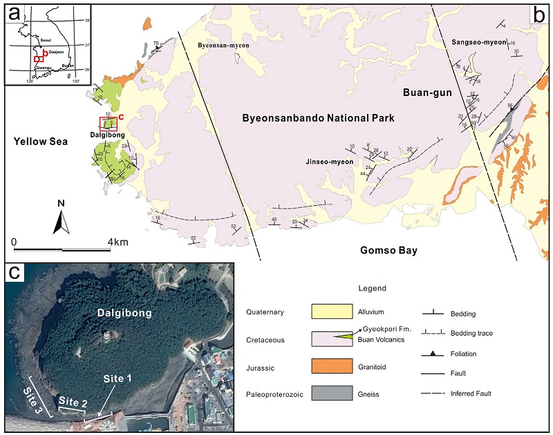
(a) Location of the study area. (b) Geological map of the Buan Volcanics (modified after Koh et al., 2013), showing the bedding trace of the strata of the volcanics is parallel to the elliptical-shaped volcanics and dipping toward the north to northwest. The Gyeokpori Formation is located on the western margin of the volcanics. (b) Aerial map of studied sites (aerial map from http://map.naver.com).
석포응회암과 곰소유문암 사이에 위치하는 두께 약 300 m의 격포리층은 주로 역암, 역질 사암, 사암, 이암으로 구성되어 있으며, 유문암질(화산력)응회암이 여러 층준에 협재되어 나타난다(Kim et al., 2003). Kim et al. (2003)은 퇴적상과 퇴적상 조합을 통해 격포리층을 (1) 수중 암추(subaqueous talus), (2) 삼각주 평원(delta plain), (3) 급경사진 큰 규모의 삼각주 사면(large-scaled steep-sloped delta system), (4) 삼각주사면 기저부-전삼각주(base of delta slope to prodelta), (5) 작은 규모로 둥우리진 길버트형 삼각주(small-scaled nested Gilbert-type delta), (6) 작은 규모의 삼각주-로브 시스템(small-scaled delta-lobe system), (7) 수중 팬(subaqueous fan), 그리고 (8) 분지 평원(basin plain) 등의 다양한 퇴적환경으로 구분하였고, 이들은 호수 환경에서 발달한 사태/미끄럼사태(slump/slide), 무점착성 쇄설류(cohesionless debris flow), 암석낙하(debris fall), 저밀도에서 고밀도 저탁류(low- and high-concentrated turbidity cur-rents) 등의 다양한 퇴적작용에 의해 퇴적된 것으로 해석하였다. Kim et al. (2003)은 분지전반에 나타나는 상향세립화 경향을 통해 격포리층을 크게 하부 연계층(lower succession; 0~215 m)와 상부 연계층(upper succession; 215~290 m)로 구분하였으며, 본 논문의 연구 대상인 연질퇴적변형구조는 하부 연계층과 상부 연계층의 경계부(약 200~230 m 구간)의 이암층 내에 발달하고 있다. 격포리층과 곰소유문암의 경계를 따라서는 페퍼라이트(Choi et al., 2001), 하중구조 그리고 불꽃구조가 관찰된다. 격포리층 내의 화산쇄설암의 협재, 페퍼라이트 그리고 연질퇴적변형구조 등은 격포리층을 구성하고 있는 퇴적물이 완전히 고화되기 전에 분지주변의 화산활동(부안화산암)에 의해 직·간접적인 영향을 받았음을 지시한다. 격포리층의 고유향 측정결과는, 분지의 퇴적계가 전반적으로 분지의 남쪽 가장자리에서는 북쪽, 북동 그리고 북서 방향으로, 분지의 북쪽 가장자리에서는 남쪽 그리고 남서 방향으로 발달함을 보여준다(Kim et al., 2003). 이러한 고유향의 방향은 격포리층 퇴적 당시 전반적인 분지의 바닥(basin floor)이 북 내지 북서쪽으로 기울어졌고 분지의 퇴적중심지(depocenter) 또한 같은 방향에 위치하고 있었음을 지시한다.
2.2 지층 경동
부안화산암의 내부에 인지되는 층리 및 지층경계의 궤적은 비교적 일정한 경향성을 가지며 변화한다. 이들 지질요소의 공간적 궤적은 위치 및 분포 지층의 종류에 따라 편차가 존재하나 전반적으로 타원형의 화산암체와 평행 내지 아평행함을 유지하며 변화하는 특징을 보인다(그림 2).
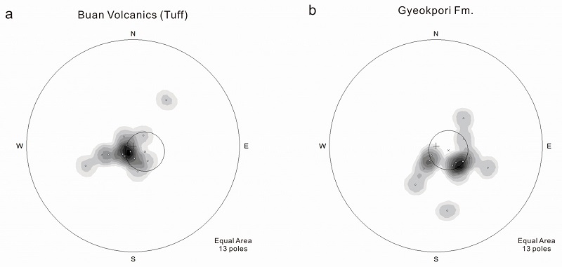
부안화산암의 화산암들의 경우 전반적으로 남측의 지층은 동북동-서남서~서북서-동남동 방향의 주향을 가지고 북쪽으로 경사하는 양상을 보여주며 반면, 동측 지층은 북동-남서 주향을 가지고 북서쪽으로 경사하는 형태를 보인다(그림 2). 이들 층리 자료를 하반구 투영한 결과, 극점의 분포가 하나의 대원(great circle) 보다는 정점각(apical angle)이 약 30° 인 아수직의 원뿔(cone)에 근사함을 보인다(그림 3a). 이러한 투영 결과는 지층 분포 형태가 부안화산암 중심부를 향해 완만하게 경사지는 깔때기 모양과 유사함을 지시한다. 암상 중심으로 경사지는 깔때기형 지층 분포는 격포리층에서도 인지된다(그림 3b). 이러한 깔때기형의 지층 분포는 기하학적 특성상 압축응력에 의한 좌굴습곡(buckling fold)이 아닌 화산체의 붕괴 및 침강에 수반된 수동적인 지층 경동에 기인한 것으로 판단된다(Park, 1997).
3. 연질퇴적변형구조의 산상
격포리층 내에 관찰되는 연질퇴적변형구조는 격포분지(Kim et al., 2003) 중앙에 위치한 타원 모양의 닭이봉 남쪽 해안가를 따라 동일 층준 내에 연속적 또는 단속적으로 발달하고 있다. 연질퇴적변형구조는 이암층 내 최대 두께 약 2 m와 이 이암 상위의 두께 약 1.5 m의 역암층에서 관찰되며, 이 두 층은 변형 받지 않은 두께 약 0.2 m의 이암층에 의해 구분된다(그림 4). 연질퇴적변형구조의 하부 경계는 뚜렷하고 편평한 반면, 상부 경계는 변형구조의 기복 때문에 완만하게 굴곡진 형태를 보인다. 연질퇴적변형구조는 조사 지점에 따라 상이한 기하학적 발달 특징을 보이고 있어, 본 연구에서는 크게 3개의 조사지점(동에서부터 서쪽으로 조사지점 1, 2, 3)으로 구분하였다(그림 2c; 표 1). 조사지점 1과 2는 주로 동-서 방향의 수직 노두 단면에서, 조사지점 3은 다양한 방향의 수직-수평 노두 단면에서 변형구조가 잘 관찰된다. 변형구조요소는 구조가 연속적이며 잘 보존된 이암 내 변형구조에서 측정하였다.
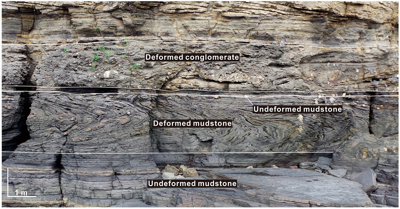
The photograph showing deformed mudstone and conglomerate layers, which distinguished by undeformed mudstone layer between them.
조사지역의 연질퇴적변형구조는 운동학적 특성에 따라 크게 수축변형구조(예, 습곡, 충상단층 등)와 신장변형구조(예, 정단층, 부딘 등)로 구분할 수 있다. 하지만 조사지역에는 연질퇴적변형작용에 수반되어 발달한 단층들과 이후의 취성변형작용에 의해 생성된 단층들이 함께 발달하고 있기 때문에 이에 대한 구별이 필요하다. 연질퇴적변형작용에 수반된 단층들은 단층선이 비 변형된 이암층으로 연장되지 않고 변형된 층준 내에서도 특정 층만을 절단하는 특징을 보인다(Neuwerth et al., 2006). 따라서 본 연구에서는 변형작용을 받은 이암 내에서만 발달하는 단층들만을 선별하여 측정하였다. 아울러 연질퇴적변형작용 이후의 구조운동의 영향(e.g., 지층 경동)을 제거하기 위하여 측정된 구조요소들은 스트레오넷(stereonet 8) 프로그램을 이용하여 경사보정을 실시하였다.
3.1 조사지점 1 (site 1)
닭이봉 남중앙에 위치한 조사지점 1은 습곡들이 수축변형 받은 층준의 중·상부(높이 1~2 m 구간) 부분에 집중적으로 발달하고 있으며, 각각의 습곡은 측방으로의 연속성이 불량하다(폭 <5 m)(그림 5a). 습곡들은 양쪽 날개부(limb)의 길이가 서로 다른 비대칭습곡(asymmetry fold)으로 전반적으로 시계방향의 회전을 지시하는 동쪽 전향(east-verging)의 습곡이 우세하며 일부 반시계방향의 회전을 지시하는 서쪽 전향(west-verging)의 습곡이 관찰된다(그림 5a & b). 습곡들의 습곡축면의 경사각과 습곡힌지의 침강각은 약 10~30° 로 Fluety (1964) 습곡분류법의 완만경사습곡(gently inclined fold)과 완만침강습곡(gently plunging fold)에 각각 대응된다(그림 5a). 습곡의 익간각(interlimb angle)은 대부분 30~70° 내외인 폐쇄습곡(close fold)으로(그림 5a; Twiss and Moores, 2007), 일부는 습곡의 양 날개가 거의 평행한 등사습곡(isoclinal fold)의 형태를 보이기도 한다(그림 5b). 습곡 힌지(hinge)의 방향(trend)은 북동 혹은 남서 방향으로 20° 미만으로 경사져 있다(그림 5c). 습곡축면은 다소 분산된 양상을 보이지만, 주로 북북서-남남동 또는 북북동-남남서 주향 방향이며, 이들은 각각 북동과 남서 방향으로 경사져 있다(그림 5d).
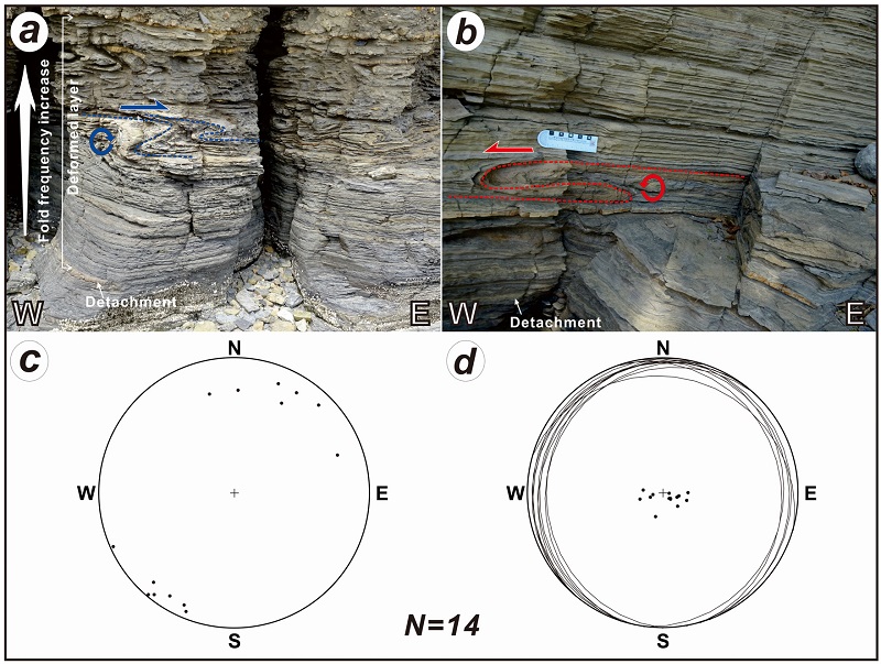
Characteristics of fold geometry at site 1. Outcrop photographs showing east-verging (a) and west-verging (b) folds. It is noteworthy that the east-verging folds are mainly occurred in the middle to upper part of the deformed layer, while the west-verging folds at the bottom. Stereographic projection (lower hemisphere, equal area) of fold hinges (c) and axial planes (d).
연질퇴적변형작용에 수반된 단층은 크게 충상단층(thrust)과 정단층으로 구분된다(그림 6a-6d). 충상단층은 습곡과 함께 발달하며, 일부는 습곡축면을 변위시키며 발달하고 있다. 충상단층의 최대 변위는 약 10 cm 내외이며(그림 6b), 단층면은 북북서 내지 북서 주향에 30° 미만의 저각으로 남서쪽으로 경사져 있다(그림 6e). 정단층은 변형된 층준의 하부(<1 m 높이)에 집중적으로 발달하고 있으며(그림 6a), 부딘과 함께 결합되어 전단띠 부딘(shearband boudin; Goscombe et al., 2004)의 형태로 관찰된다(그림 6c). 최대 변위는 5 cm 이내 이다(그림 6d). 정단층의 방향은 층준에 따라 상이하게 관찰되는데, 남북 주향에 동쪽 경사 방향을 보이는 정단층은 전술한 충상단층 주변에 나타나는 반면, 동서 주향에 북쪽 경사 방향의 정단층은 층의 하부에 주로 발달한다(그림 6f).
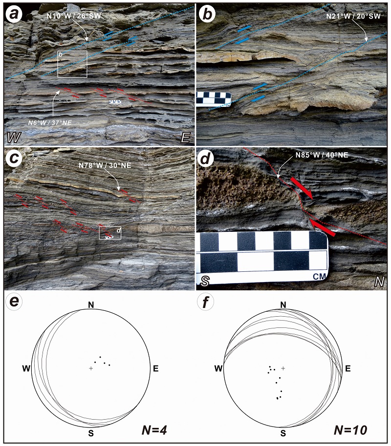
Characteristics of fault geometry at site 1. (a) An outcrop photograph showing the coexistence of NNW-trending thrust and normal fault in the upper part of the deformed layer. It is notable that the spatial distribution of the faults with two contrasting kinematic styles is controlled by a detachment located at the center of the photograph. (b) An enlarged photograph of thrusts cutting through axial surfaces of asymmetric folds. (c) An outcrop photograph showing WNW-trending normal fault and shear-band boudin in the lower part of the deformed layer. (d) An enlarged photograph of the shear-band boudin with a dip-separation of ca. 3cm. Stereographic projection (lower hemisphere, equal area) of thrusts (e) and normal faults (f).
3.2 조사지점 2 (site 2)
이 지점은 닭이봉 남서쪽에 위치하고 있으며, 조사지점 1에 비해 규모가 크고(약 2 m 두께) 측방으로 연속성이 좋은(폭 >100 m) 습곡구조가 발달하고 있다. 하지만 조사지점 1과 같은 단층들은 관찰되지 않는다. 전반적인 주 습곡의 기하학적 형태는 습곡의 상부 날개부의 길이가 하부 날개부보다 긴 비대칭습곡이며, 전반적으로 시계방향의 회전을 지시하는 동남동쪽 전향(ESE-verging)의 습곡이 우세하다. 이에 수반된 기생습곡(parasitic fold)은 주 습곡의 힌지부에서 M자형 습곡, 상부 날개부에서는 Z자형 습곡, 하부 날개부에서는 S자형 습곡 그리고 하부 경계부에는 주 습곡의 축면 경사 방향과 반대인 박스형 습곡 구조가 관찰된다(그림 7a). M자형 습곡의 힌지부에는 힌지방향과 평행한 방향으로 파랑힌지(crenulation hinges)들이 발달해 있다(그림 7b). 주 습곡의 습곡축면 경사각과 습곡 힌지의 침강각은 모두 10° 미만으로, 횡와습곡(recumbent fold)으로 분류된다(그림 7a; Fluety, 1964). 습곡의 익간각은 10~30°로 조임습곡(tight fold)에 해당된다. 습곡힌지의 방향(trend)은 북동 혹은 남서 방향으로 10° 미만으로 경사져 있다(그림 7c). 습곡축면은 북동 주향에 북서쪽으로 경사져 있다(그림 7d).
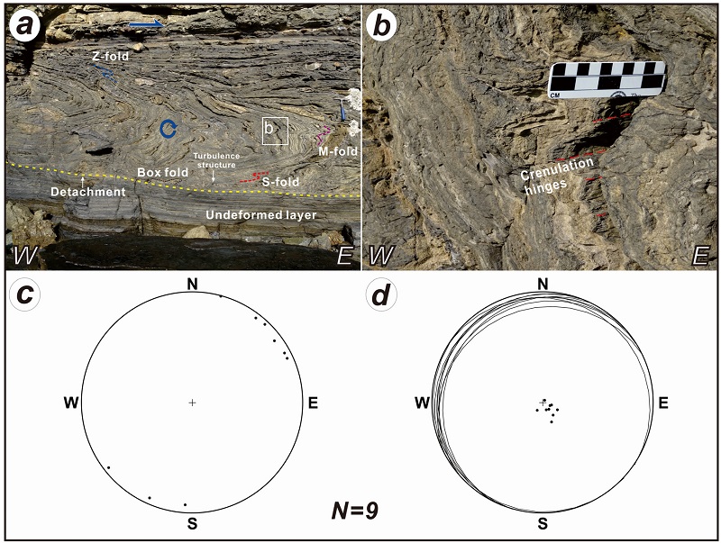
Characteristics of fold geometry at site 2. (a) An outcrop photograph showing recumbent, asymmetric fold verging toward ESE-direction on a detachment. Z-, M-, S-shaped parasitic folds are well developed. (b) An enlarged photograph of hinge zone of the asymmetric fold. It is notable that higher order crenulation fold is cogenetically occurred parallel to the first order asymmetric fold. Stereographic projection (lower hemisphere, equal area) of fold hinges (c) and axial planes (d).
3.3 조사지점 3 (site 3)
이 지점은 닭이봉 서쪽 해안가에 위치하고 있다. 습곡의 규모(층의 두께와 측방연장성) 및 노두에서 관찰되는 습곡축면의 경사각, 습곡 힌지의 침강각 그리고 습곡의 익간각은 조사지점 2와 유사하다. 이 지점은 다른 두 지점과 달리 다양한 방향의 노두 단면에서 서로 다른 여러 방향으로 전향하는 습곡이 관찰된다(그림 8a). 평면상에서 관찰되는 습곡의 힌지는 완만한 곡선의 형태를 보이고 있으며, 습곡들의 궤적(trace)은 북동-남서 내지 동-서 방향의 방향성을 보인다(그림 8b). 습곡힌지의 방향은 이전 두 지점과 같은 북동 혹은 남서 방향뿐만 아니라, 북서 혹은 남동 방향까지 관찰되는 매우 분산된 형태를 보이고 있다(그림 8c). 그리고 습곡축면도 매우 분산되어져 있어 우세한 방향을 특정하기 어렵다(그림 8d).
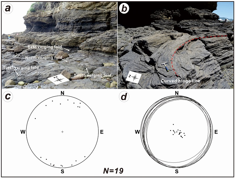
Characteristics of fold geometry at site 3. (a) An outcrop photograph showing various directions of fold verging well observed compared with other sites. (b) An outcrop photograph showing gently curved fold hinge-line is well exposed. Stereographic projection (lower hemisphere, equal area) of fold hinges (c) and axial planes (d).
4. 운동학적 해석
조사지점 3에서 관찰되는 분산된 형태의 습곡축 분포 그리고 곡선형의 습곡 힌지의 특징은 이암층 내 발달하고 있는 습곡들이 높은 전단응력변형(shear strain)을 받아 형성된 비원통형 습곡(non-cylinder-ical fold)임을 지시하며, 이러한 강력한 전단응력변형은 퇴적물의 사태(slumping)에 의해 형성되는 것으로 알려져 있다(Fossen, 2010). 조사지점에 따라 서로 다른 습곡의 기하학적 형태, 분포 그리고 규모 등은 차별적인 응력작용을 받았음을 지시하며, 이는 사태에 의한 퇴적물의 유동이 하나의 거대 셀 형태의 유동(single-cell flow; Farrell, 1984) 보다는 퇴적물의 불균질성에 기인한 다중셀 유동(multi-cell flow)에 의해 형성된 것으로 해석된다(Alsop and Marco, 2014). 조사지점 1에 비해 상대적으로 큰 규모의 습곡구조를 보이는 조사지점 2와 3은 상대적으로 많은 응력변형작용을 받았음을 지시하며, 이 두 지역이 퇴적물 유동이 보다 강했던 것으로 해석된다. 시계방향의 회전을 지시하는 동쪽 전향 습곡(조사지점 1) 그리고 주 습곡 주변에 수반되어 나타나는 다양한 기생습곡(조사지점 2; 주 습곡의 힌지부의 M자형 습곡, 상부 날개와 하부 날개의 각각 Z자형과 S자형 습곡)들의 기하학적 형태 특징은 주 습곡의 형성이 서쪽에서 동쪽으로 이동하는 퇴적물의 유동에 의해 형성되었음을 지시한다.
연질퇴적변형작용에 수반되어 형성되는 단층들의 경우, 정단층면의 경사방향은 퇴적물의 유동 방향과 동일한 방향으로 발달하는 반면, 충상단층면의 경사방향은 주로 반대 방향으로 발달한다(Maltman, 1994; Stranchan, 2008; Debacker et al., 2009; Debacker and De Meester, 2009). 조사지점 1에 함께 관찰되는 남서쪽으로 경사진 충상단층과 동쪽 방향으로 경사진 정단층은 퇴적물의 유동이 서에서 동으로 이동하였음을 지시하며, 이는 습곡에서 관찰되는 기하학적 형태와 잘 일치한다. 반면 변형된 지층의 하부에 발달하는 북쪽 경사 방향의 정단층은 남에서 북으로의 퇴적물 유동이 있었음을 지시하는데, 이러한 다중셀 유동에 의해 운반되는 퇴적물은 동일한 지층 내에서도 층준에 따라 다양한 변형작용을 받을 수 있음을 보여준다(e.g., Alsop and Marco, 2014).
5. 고경사 방향 해석
사태에 의해 사면을 이동하는 퇴적물은 그 내부에 다양한 형태의 습곡과 이에 수반된 정·역단층들을 형성하게 되며, 이러한 연질퇴적변형구조의 기하학적 형태와 방향성은 다양한 환경에서의 사면의 경사 방향(또는 퇴적물의 유동 방향)을 유추하는데 널리 적용되어 왔다(Alsop and Marco, 2014 and references therein). 이러한 경사 방향 유추를 위한 변형구조 방향성의 통계처리 방식은 평균축 방법[Mean Axis Method (MAM); Jones (1939)]과 호분리 방법[Seperation Arc Method (SAM); Hansen (1971)]이 주로 사용되어져 왔다. 하지만 이 방법들은 연질퇴적변형작용을 받는 퇴적물이 균질한 유동작용에 의해 원통형 습곡을 형성하고 변형작용을 받는 동안 습곡의 전향(vergence)은 경사방향을 따라 일정하게 발달해야 한다는 가정이 전제되어져야 한다. 따라서 이들 방법은 습곡 힌지 및 축면의 방향이 분산되지 않고 일정한 방향성을 보이는 지역에서만 적용 가능하며, 본 연구지역처럼 다양한 전향 방향을 갖는 비원통형 습곡이 발달하는 지역에서는 적용할 수 없는 단점이 있다.
최근 Strachan and Alsop (2006)은 원통형 습곡과 비원통형 습곡 내 힌지 방위각과 익간각의 상관관계[comparision of Fold Hinge azimuth and Interlimb angle (HIM)]를 통해 사태에 의해 유동하는 퇴적물의 운반 방향 그리고 고경사 방향 추론 방법을 제시하였다. 먼저 원통형 습곡이 만들어 지는 경우, 사면을 따라 유동하는 퇴적물은 공간적 위치에 관계없이 일정한 전단응력변형작용이 가해지기 때문에 습곡 힌지(습곡 축)의 차별적인 회전량이 없다. 따라서 공간적으로 다양한 범위값을 갖는 익간간은 일정하고 뚜렷한 2개의 방향값(습곡 힌지의 방위각)으로 구분되고, 이 두 방향은 고사면의 주향을 지시함을 설명하였다[Strachan and Alsop (2006)의 그림 10a]. 반면 비원통형 습곡의 경우, 사면을 따라 유동하는 퇴적물은 공간적 위치에 따라 차별적인 전단응력변형작용이 가해지고, 그 결과 차별적인 습곡 힌지의 회전량에 의해 습곡의 밀착도(tightness)가 달라짐을 이용한 방법이다. 즉, 전단응력을 가장 많이 받는 사면 중심부에서는 퇴적물 내의 습곡 힌지의 회전량이 많아 습곡의 밀착도가 증가하여 익간각은 감소하는 반면, 중심부에서 멀어질수록 습곡 힌지의 회전량은 상대적으로 감소하여 밀착도가 감소하고 익간각은 증가하는 것이다. 따라서 비원통형 습곡의 이상적인 습곡 힌지 방위각과 익간각의 그래프 모양은 익간각이 사면의 주 경사 방향(또는 퇴적물 이동 방향)으로 값이 감소하는 완만한 V형의 분포양상임을 보여준다[Strachan and Alsop (2006)의 그림 10b]. 하지만 Strachan and Alsop (2006)은 실제 야외에서 측정되는 습곡 힌지의 회전(e.g., fold data of the Fisherstreet Slump)은 두 단성분의 중간 단계도 충분히 나타날 수 있음을 제시하였으며, 이 경우 익간각의 분포에 의해 구분되는 2개의 그룹은 고사면의 주향방향을 지시함을 설명하였다. 그리고 이 주향방향의 90° 방향에 위치한 두 방향의 사면 경사 방향 중, 퇴적물이 유동한 경사 방향은 습곡의 전향방향과 동일한 방향으로 추정하였다.
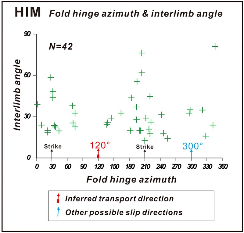
Hinge Interlimb Method (HIM) plot of fold hinge azimuth and interlimb angle data, suggesting a preferred slope direction of 120°.
연구지역에 관찰되는 습곡 힌지 방위각과 익간각을 그래프로 도시해 본 결과, 분산된 익간각은 크게 두 방향(약 30°와 210°)에서 그룹되어 나타난다. 따라서 고사면의 주향은 NNE-SSW로 해석할 수 있으며, 사면의 경사 방향은 동남동(약 120°) 또는 서북서(약 300°) 두 방향 중 하나일 것으로 추정된다. 본 연구지역의 습곡이 동쪽으로 전향하고 있는 점 그리고 충상단층과 정단층 모두 서쪽에서 동쪽으로의 전단작용을 지시하는 점은 퇴적물의 변형작용이 서쪽에서 동쪽 방향으로의 전단작용에 의해 형성되었음을 지시하며, 이는 동남동쪽으로 기울어진 고사면을 따라 퇴적물이 유동하면서 습곡과 이에 수반된 단층들을 형성한 것으로 해석된다.
6. 사태형성 원인
백악기 호성 퇴적분지 중 하나인 격포분지는 북동-남서 주향 방향의 좌수향 주향이동성 단층의 구조운동에 의해 형성된 인리형 분지로 해석되어 왔다(Kim et al., 2003). 최근 부안지역의 정밀 지질도 작성 결과는 격포분지가 최대직경 약 20 km의 부안화산암 서편 가장자리에 위치하며, 쇄설성퇴적암과 화산쇄설암으로 구성된 격포리층(Kim et al., 1995, 2003)은 부안화산암의 여러 층서단위 중 하나에 포함되는 것으로 보고하였다(Koh et al., 2013). 이는 분지의 확장에 따른 구조운동뿐만 아니라, 분지 주변의 화산활동 또한 격포분지 형성과 층서발달/변형에 직·간접적으로 영향을 주었음을 지시한다.
세립질 퇴적층에서 관찰되는 다양한 크기의 연질퇴적변형구조들은 퇴적물이 퇴적되는 동안 또는 퇴적 직후에 주로 형성되는데, 이러한 변형구조를 야기한 원인에는 상위 퇴적층의 과하중, 지진 충격파에 따른 지층의 흔들림에 의한 액상화 작용 그리고 지층의 흔들림에 의한 중력 주도 사태 등이 있다(Owen, 1996, 2003; Shiki et al., 2000; Montenat et al., 2007; Moretti and Sabato, 2007; Owen and Moretti, 2008; Alfaro et al., 2010; Alsop and Marco, 2011; Moretti and Ronchi, 2011a; Owen et al., 2011; Alsop and Marco, 2012, 2013, 2014). 전자 두 개의 작용은 후자와 비교하여 아주 짧은 시간에 그리고 상대적으로 좁은 구간에서의 변형작용을 야기 시켜 변형구조의 규모가 작은(<수 m; Moretti and Sabato, 2007) 반면, 후자의 경우 퇴적물의 유동 정도에 따라 다양한 크기의 그리고 큰 규모(수 m에서 수 십 m 이상)의 변형구조가 형성된다(Alsop and Marco, 2011). 최근 Alsop and Marco (2013)은 초 저각(<1°)의 사면에서도 중력 주도 사태에 의해 연질퇴적변형구조가 발달할 수 있음을 제시하였는데, 편평한 분지 평원(basin plain)에 발달한 세립질 저탁류(Bouma, 1962)에 의해 형성된 것으로 해석되는 흑색 이암(Kim et al., 2003) 내 측방 연장성(> 200 m)이 좋은 연질퇴적변형구조는 거의 편평한(<1°) 분지 평원에서 발생한 중력 주도 사태에 의해 변형구조가 형성된 것으로 해석된다.
퇴적 분지에서 퇴적물의 유입, 퇴적 시스템의 발달 그리고 중력 주도 사태 등은 주로 주 단층의 침강작용 활동이 우세하여 분지의 바닥이 깊어지는 퇴적중심지(depocenter)로 이동하게 된다(Miall, 1984). 격포리층 내 소규모 단층들의 운동학적 분석결과는 격포분지가 동-서에서 동북동-서남서 방향으로의 확장에 의해 분지가 형성되었음을 보여준다(Lambiase and Bosworth, 1995; Lee, 2011). 또한 격포리층의 고유향 측정결과는 격포분지의 퇴적계가 북 내지 북서쪽으로 발달함을 보여준다(Kim et al., 2003). 이러한 구조학적 및 퇴적학적 연구결과는 격포분지가 북 내지 북서쪽으로 분지의 바닥이 기울어졌고 퇴적중심지가 이 방향에 위치했던 것으로 해석된다(Kim et al., 2003). 만약 분지의 확장에 따른 분지 경계단층의 침강작용이 발생하여 분지 평원에서 사태가 발생하였다면, 퇴적물은 퇴적중심지인 북 내지 북서쪽으로 유동하면서 연질퇴적변형구조를 만들어야만 한다. 하지만 닭이봉의 연질퇴적변형구조가 분지의 퇴적중심지 및 퇴적계 발달 방향과 반대인 남동쪽으로 기울어진 고사면에 의해 형성되는 점은 사태가 분지 경계단층의 침강운동에 기인한 것으로 해석하기 어렵다.
격포분지 동편에 격포리층과 동시기에 형성된 타원형의 독립적인 부안화산암은 많은 화산암류와 퇴적암으로 구성되어 있으며(Koh et al., 2013), 이러한 특징은 부안화산암이 다양한 화산분출작용에 의해 화산암류들이 집적되어 형성된 칼데라로 해석된다(Cas and Wright, 1987; Gottsmann et al., 2008 and references therein). 이러한 칼데라의 화산분출작용은 칼데라 지하에 위치한 마그마방을 비우게 되며, 그 결과 마그마방의 붕괴와 이에 수반된 많은 단층작용에 의해 칼데라 주변 지층은 화구쪽으로 수렴하는 지괴 경동이 발생한다(Gottsmann and Marti, 2011 and references therein). 따라서 닭이봉의 연질퇴적변형구조를 형성시킨 고사면의 방향이 분지의 퇴적중심지가 아닌 부안화산암쪽으로 기울어진 점은 이 퇴적동시성 변형구조를 야기 시킨 사태가 화산의 분출에 따른 지층의 경동에 의해 형성될 수 있음을 유추케 한다. 이러한 화산분출에 따른 지층의 경동은 화산의 최후기까지 지속되어 부안화산암의 지층 경사의 공간적 궤적이 부안화산암을 향해 깔때기 모양으로 수렴한 것으로 판단된다(그림 3).
하지만 일반적으로 고사면에 의한 점진적인 퇴적물의 유동은 주향방향과 수직한 방향으로 시작되지만, 계속적인 중력 주도 사태가 진행되면서 국부적인 사태의 방향 변화가 발생하는 것으로 알려져 있다(Butler, 1987). 특히 사태의 말단부(toe of slump)에서는 전진 또는 측방 로브의 방사형 측방 퍼짐(radial lateral spreading)이 발생하게 되는데, 이러한 국부적인 발산 유동 패턴은 변형작용 동안에 항상 일정한 기하학적인 변형구조만 생성되는 것이 아님을 설명해 준다(Strachan and Alsop, 2006). 따라서 닭이봉에서의 남동쪽 방향의 고경사 방향은 전체적인 고사면의 방향이 아닌 사태의 말단부에서 나타나는 국부적인 유동방향일 가능성도 있다. 향후 격포분지 내 연질퇴적변형구조의 정확한 형성 원인을 해석하기 위해서는 주막 및 봉화산 일대에서도 관찰되는 서로 다른 층준의 연질퇴적변형구조에 대한 추가적인 조사가 수행되어져야 할 것으로 사료된다.
7. 결 론
백악기 부안화산암의 서편 가장자리에 위치하고 있는 격포분지 격포리층(Kim et al., 1995)은 주로 쇄설성퇴적암과 이들 내에 협재된 여러 화산쇄설암으로 구성되어있으며, 최근의 지질도 작성 결과(Koh et al., 2013)는 격포리층이 부안화산암의 다양한 층서단위 중 하나에 포함됨을 보여준다. 이러한 화산암과의 공간적 분포 양상 및 분지충전물의 암상 특징은 격포분지의 형성 및 퇴적계 발달이 화산작용의 영향을 많이 받았음을 나타낸다. 격포분지 흑색 이암층 내에 발달하는 연질퇴적변형구조는 여러 조사들에 의해 보고된 바 있는데, Lee (2011)은 이 변형구조를 분지에 서에서 동으로 작용한 횡압력에 의해 형성된 것으로 설명한 반면, Kim et al. (2003)은 퇴적동시성 변형작용에 의해 형성된 것으로 해석하였으나 형성기작에 대해서는 명확한 설명을 하진 못하였다. 이번 연구에서는 격포분지 퇴적층 내 특정 층준에 측방 연속성 있게 발달하고 있는 연질퇴적변형구조는 횡압력에 의한 변형보다는 퇴적 동시기 또는 퇴적 직후에 물 또는 습기를 머금은 퇴적물이 고사면을 따라 이동하여 형성된 것으로 판단된다. 특히 분지 평원에서 퇴적된 흑색 이암 내에 연질퇴적변형구조가 발달하는 특징은 이 변형구조가 아주 완만한 경사면(<1°)에서 발달한 사태에 의해 형성되었던 것으로 해석되는데, 이는 퇴적물 내에 포함된 물이 윤활유와 같은 작용을 하여 퇴적물이 평지를 잘 이동할 수 있었던 것으로 보인다. 습곡 힌지의 방위각과 익간각의 상호관계를 이용하여 복원된 고경사 방향은 분지의 퇴적중심지와 반대방향인 부안화산암쪽으로 기울어져 있음을 보여주는데, 이는 화산체 주변에 발달하는 퇴적 분지는 분지의 형성 및 퇴적시스템 뿐만 아니라 분지충전물의 퇴적 동시성 변형작용도 화산작용에 의해 많은 영향을 받을 수 있음을 유추케 한다. 이러한 분지 형성에 따른 화산작용의 영향은 퇴적분지의 발달 및 변형구조 해석에 있어 구조운동뿐만 아니라 화산작용도 중요한 변수로 고려해야 됨을 보여준다.
Acknowledgments
이 논문은 한국지질자원연구원의 ‘한반도 중서부의 층서지구조 규명 및 통합지질정보시스템 구축(15-3111)’에 의해 지원을 받아 수행되었습니다. 논문을 심사하여 세심하고 건설적인 조언을 해주신 강희철 박사님, 충북대학교 이철우 교수님, 그리고 편집위원님께 깊은 감사드립니다.
References
-
Alfaro, P., Gibert, L., Moretti, M., García-Tortosa, F.J., Sanz de Galdeano, C., Galindo-Zaldívar, J., and López-Garrido, T.C., (2010), The significance of giant seismites in the Plio-Pleistocene Baza palaeo-lake (S Spain), Terra Nova, 22, p172-179.
[https://doi.org/10.1111/j.1365-3121.2010.00930.x]

-
Alsop, G.I., and Marco, S., (2011), Soft-sediment deformation within seismogenic slumps of the Dead Sea Basin, Journal of Structural Geology, 33, p433-457.
[https://doi.org/10.1016/j.jsg.2011.02.003]

-
Alsop, G.I., and Marco, S., (2012), Tsunami and seichetriggered deformation within offshore sediments, Sedimentary Geology, 261-262, p90-107.
[https://doi.org/10.1016/j.sedgeo.2012.03.013]

-
Alsop, G.I., and Marco, S., (2013), Seismogenic slump folds formed by gravity-driven tectonics down a negligible subaqueous slope, Tectonophysics, 605, p48-69.
[https://doi.org/10.1016/j.tecto.2013.04.004]

-
Alsop, G.I., and Marco, S., (2014), Fold and fabric relationships in temporally and spatially evolving slump systems: A multi-cell flow model, Journal of Structural Geology, 63, p27-49.
[https://doi.org/10.1016/j.jsg.2014.02.007]

-
Berra, F., and Felletti, F., (2011), Syndepositional tectonics recorded by soft-sediment deformation and liquefaction structures (continental Lower Permian sediments, Southern Alps, Northern Italy): Stratigraphic significance, Sedimentary Geology, 235, p249-263.
[https://doi.org/10.1016/j.sedgeo.2010.08.006]

- Bouma, A.H., (1962), Sedimentology of Some Flysch Deposits, Elsevier, Amsterdam.
- Branney, M.J., and Kokelaar, P., (2002), Pyroclastic density currents and the sedimentation of ignimbrites, Geol. Soc. Lond. Mem. Lond, 27, p152.
-
Butler, R.W.H., (1987), Thrust sequences, J. Geol. Soc. London, 144, p619-634.
[https://doi.org/10.1144/gsjgs.144.4.0619]

-
Cas, R., and Wright, J., (1987), Volcanic Successions: Modern and Ancient, Allen y Unwin, London, p518.
[https://doi.org/10.1007/978-94-009-3167-1]

- Choi, S.W., Lee, Y.E., Park, K.H., and Lee, C.H., (2001), Occurrences and formation model of peperite in the Jugmagri area, Byeonsan Peninsula, Korea, Journal of the Geological Society of Korea, 37, p297-308, (in Korean with English abstract).
- Chough, S.K., (2013), Geology and Sedimentology of the Korean Peninsula, Elsevier, Amsterdam.
-
Debacker, T.N., Dumon, M., and Matthys, A., (2009), Interpreting fold and fault geometries from within the lateral to oblique parts of slumps: a case study from the Anglo-Brabant Deformation Belt (Belgium), J. Struct. Geol, 31, p1525-1539.
[https://doi.org/10.1016/j.jsg.2009.09.002]

- Debacker, T.N., and De Meester, E., (2009), A regional, S-dipping late Early to Middle Ordovician palaeoslope in the Brabant Massif, as indicated by slump folds (Anglo-Brabant Deformation Belt, Belgium), Geologica Belgica, 12, p145-159.
-
Doughty, M., Eyles, N., Eyles, C.H., Wallace, K., and Boyce, J.I., (2014), Lake sediments as natural seismographs: Earthquake-related deformations (seismites) in central Canadian lakes, Sedimentary Geology, 313, p45-67.
[https://doi.org/10.1016/j.sedgeo.2014.09.001]

-
Engebretson, D.C., Cox, A., and Gordon, R.G., (1984), Relative motions between oceanic plates of the Pacific Basin, Journal of Geophysical Research, 89, p10291-10310.
[https://doi.org/10.1029/JB089iB12p10291]

-
Ettensohn, F.R., Zhang, C., Gao, L., and Lierman, R.T., (2011), Soft-sediment deformation in epicontinental carbonates as evidence of paleoseismicity with evidence for a possible new seismogenic indicator: Accordion folds, Sedimentary Geology, 235, p222-233.
[https://doi.org/10.1016/j.sedgeo.2010.09.022]

-
Fleuty, M.J., (1964), The description of folds, Proc. Geol. Assoc, 75, p461-492.
[https://doi.org/10.1016/S0016-7878(64)80023-7]

-
Farrell, S.G., (1984), A dislocation model applied to slump structures, Ainsa Basin, South Central Pyrenees, Journal of Structural Geology, 6, p727-736.
[https://doi.org/10.1016/0191-8141(84)90012-9]

-
Fossen, H., (2010), Structural Geology, Cambridge University Press, Cambridge.
[https://doi.org/10.1017/CBO9780511777806]

-
Goscombe, B.D., Passchier, C.W., and Hand, M., (2004), Boudinage classification: end-member boudin types and modified boudin structures, Journal of Structural Geology, 26, p739-763.
[https://doi.org/10.1016/j.jsg.2003.08.015]

- Gottsmann, J., Camacho, A., Wooller, L., Martí, J., Fernández, J., Garcia, A., and Rymer, H., (2008), Shallow structure beneath the central volcanic complex of Tenerife from new gravity data, Physics of the Earth and Planetary Interiors, 168((3–4), p212-230.
- Gottsmann, J., and Martí, J., (2011), Caldera volcanism: analysis, modelling and response, Elsevier.
-
Hansen, E., (1971), Strain Facies, Springer-Verlag, Berlin, p207.
[https://doi.org/10.1007/978-3-642-65080-2]

-
Jones, O.T., (1939), The geology of theColwynBay district: a study of submarine slumping during the Salopian period, Q. J. Geol. Soc. London, 380, p335-382.
[https://doi.org/10.1144/GSL.JGS.1939.065.01-04.14]

-
Kataoka, K., (2005), Distal fluvio-lacustrine volcaniclastic resedimentation in response to an explosive silicic eruption: Pliocene Mushono tephra bed. central Japan, Geological Society of America Bulletin, 117, p3-17.
[https://doi.org/10.1130/B25379.1]

-
Kim, S.B., Chough, S.K., and Chun, S.S., (1995), Bouldery deposits in the lowermost part of the Cretaceous Kyokpori Formation, SW Korea; Cohesionless debris flows and debris falls on a steep-gradient delta slope, Sedimentary Geology, 98, p97-119.
[https://doi.org/10.1016/0037-0738(95)00029-8]

-
Kim, S.B., Chough, S.K., and Chun, S.S., (2003), Tectonic controls on spatio-temporal development of depositional systems and generation of fining-upward basin fills in a strike-slip setting: Kyokpori Formation (Cretaceous), south-west Korea, Sedimentology, 50, p639-665.
[https://doi.org/10.1046/j.1365-3091.2003.00568.x]

-
Kim, S.B., Chun, S.S., and Chough, S.K., (1997), Discussion on structural development and stratigraphy of the Kyokpo Pull-Apart Basin, South Korea and tectonic implication for inverted extensional basins, Journal of Geological Society, 154, p369-372.
[https://doi.org/10.1144/gsjgs.154.2.0369]

-
Kim, S.W., Kwon, S., Ryu, I.C., Jeong, Y.J., Choi, S.J., Kee, W.S., Yi, K., Lee, Y.S., Kim, B.C., and Park, D.W., (2012), Characteristics of the Early Cretaceous igneous activity in the Korean Peninsula and tectonic implications, Journal of Geology, 120, p625-646.
[https://doi.org/10.1086/667811]

-
Klimetz, M.P., (1983), Speculations on the Mesozoic plate tectonic evolution of eastern China, Tectonics, 2, p139-166.
[https://doi.org/10.1029/TC002i002p00139]

-
Koç Taşgın, C., (2011), Seismically-generated hydroplastic deformation structures in the Late Miocene lacustrine deposits of the Malatya Basin, eastern Turkey, Sedimentary Geology, 235, p264-276.
[https://doi.org/10.1016/j.sedgeo.2010.09.015]

-
Koç Taşgın, C., Orhan, H., Türkmen, İ, and Aksoy, E., (2011), Soft-sediment deformation structures in the late Miocene Şelmo Formation around Adıyaman area, Southeastern Turkey, Sedimentary Geology, 235, p277-291.
[https://doi.org/10.1016/j.sedgeo.2010.08.005]

- Koh, H.J., Kwon, C.W., Park, S.I., Park, J., and Kee, W.-S., (2013), Geological Report of the Julpo and Wido · Hawangdeungdo Sheets (1:50,000), Korea Institute of Geoscience and Mineral Resources, p80, (in Korean with English abstract).
- Lambiase, J.J., and Bosworth, W.P., (1995), Structural deveolpment and stratigraphy of the Kyokpo Pull-Apart Basin, South Korea and tectonic implications for inverted extensional basins, In: Basin Inversion J.G. Buchanan, and P.G. Buchanan Eds, 88, p457-471, Geological Society of London Special.
-
Le Bas, M.J., Le Maitre, R.W., Streckheisen, A., and Zanettin, B., (1986), A chemical classification of volcanic rocks based on the Total Alkali-Silica Diagram, J. Petrol, 27, p745-750.
[https://doi.org/10.1093/petrology/27.3.745]

- Lee, B.-J., (2011), Fault system in the Cretaceous Kyokpo Basin and its basement: Implications for basin formation, Journal of the Geological Society of Korea, 47, p245-254, (in Korean with English abstract).
-
Maltman, A., (1994), The Geological Deformation of Sediments, Chapman & Hall, London, p362.
[https://doi.org/10.1007/978-94-011-0731-0]

-
Manville, V., Newton, E.H., and White, J.D.L., (2005), Fluvial responses to volcanism: Resedimentation of the 1800a Taupo ignimbrite eruption in the Rangitaiki River catchment, North Island, New Zealand, Geomorphology, 65, p49-70.
[https://doi.org/10.1016/j.geomorph.2004.07.007]

-
Miall, A.D., (1984), Principles of sedimentary basin analysis, Springer, New York Heidelberg, p490.
[https://doi.org/10.1007/978-1-4757-4232-9]

-
Montenat, C., Barrier, P., Ott dEstevou, P., and Hibsch, C., (2007), Seismites: An attempt at critical analysis and classification, Sedimentary Geology, 196, p5-30.
[https://doi.org/10.1016/j.sedgeo.2006.08.004]

-
Moretti, M., and Ronchi, A., (2011a), Liquefaction features interpreted as seismites in the Pleistocene fluviolacustrine deposits of the Neuquén Basin (Northern Patagonia), Sedimentary Geology, 235, p200-209.
[https://doi.org/10.1016/j.sedgeo.2010.09.014]

-
Moretti, M., and Ronchi, A., (2011b), Liquefaction features interpreted as seismites in the Pleistocene fluvio-lacustrine deposits of the Neuquén Basin (Northern Patagonia), Sedimentary Geology, 235, p200-209.
[https://doi.org/10.1016/j.sedgeo.2010.09.014]

-
Moretti, M., and Sabato, L., (2007), Recognition of trigger mechanisms for soft-sediment deformation in the Pleistocene lacustrine deposits of the Sant'Arcangelo Basin (Southern Italy): Seismic shock vs. overloading, Sedimentary Geology, 196, p31-45.
[https://doi.org/10.1016/j.sedgeo.2006.05.012]

-
Neuwerth, R., Suter, F., Guzman, C.A., and Gorin, G.E., (2006), Soft-sediment deformation in a tectonically active area: The Plio-Pleistocene Zarzal Formation in the Cauca Valley (Western Colombia), Sedimentary Geology, 186, p67-88.
[https://doi.org/10.1016/j.sedgeo.2005.10.009]

-
Odonne, F., Callot, P., Debroas, E.-J., Sempere, T., Hoareau, G., and Maillard, A., (2011), Soft-sediment deformation from submarine sliding: Favourable conditions and triggering mechanisms in examples from the Eocene Sobrarbe delta (Ainsa, Spanish Pyrenees) and the mid-Cretaceous Ayabacas Formation (Andes of Peru), Sedimentary Geology, 235, p234-248.
[https://doi.org/10.1016/j.sedgeo.2010.09.013]

-
Owen, G., (1996), Experimental soft-sediment deformation: Structures formed by the liquefaction of unconsolidated sands and some ancient examples, Sedimentology, 43, p279-293.
[https://doi.org/10.1046/j.1365-3091.1996.d01-5.x]

-
Owen, G., (2003), Load structures: gravity-driven sediment mobilization in the shallow subsurface, In: Subsurface Sediment Mobilization P. Van Renssebergen, R.R. Hillis, A.J. Maltman, and C.K. Morley Eds, 216, p21-34, Geological Society, London, Special Publications, London.
[https://doi.org/10.1144/gsl.sp.2003.216.01.03]

-
Owen, G., and Moretti, M., (2008), Determining the origin of soft-sediment deformation structures: A case study from Upper Carboniferous delta deposits in south-west Wales, UK, Terra Nova, 20, p237-245.
[https://doi.org/10.1111/j.1365-3121.2008.00807.x]

-
Owen, G., and Moretti, M., (2011), Identifying triggers for liquefaction-induced soft-sediment deformation in sands, Sedimentary Geology, 235, p141-147.
[https://doi.org/10.1016/j.sedgeo.2010.10.003]

-
Owen, G., Moretti, M., and Alfaro, P., (2011), Recognising triggers for soft-sediment deformation: Current understanding and future directions, Sedimentary Geology, 235, p133-140.
[https://doi.org/10.1016/j.sedgeo.2010.12.010]

- Park, R.G., (1997), Foundations of Structural Geology, (third edition), Chapman and Hall, p202.
-
Rossetti, D.F., Bezerra, F.H.R., Góes, A.M., and Neves, B.B.B., (2011), Sediment deformation in Miocene and post-Miocene strata, Northeastern Brazil: Evidence for paleoseismicity in a passive margin, Sedimentary Geology, 235, p172-187.
[https://doi.org/10.1016/j.sedgeo.2010.02.005]

-
Shiki, T., Kumon, F., Inouchi, Y., Kontani, Y., Sakamoto, T., Tateishi, M., Matsubara, H., and Fukuyama, K., (2000), Sedimentary features of the seismo-turbidites, Lake Biwa, Japan, Sedimentary Geology, 135, p37-50.
[https://doi.org/10.1016/S0037-0738(00)00061-0]

- Smith, G.A., (1987), The influence of explosive volcanism on fluvial sedimentation: the Deschutcs Formation (Neogenet in central Oregon, J. Sediment. Petrol, 57, p613-629.
-
Strachan, L.J., (2008), Flow transformations in slumps: a case study from the Waitemata Basin, New Zealand, Sedimentology, 55, p1311-1332.
[https://doi.org/10.1111/j.1365-3091.2007.00947.x]

-
Strachan, L.J., and Alsop, G.I., (2006), Slump folds as estimators of palaeoslope: a case study from the Fisherstreet Slump of County Clare, Ireland, Basin Research, 18, p451-470.
[https://doi.org/10.1111/j.1365-2117.2006.00302.x]

- Twiss, R., and Moores, E., (2007), Structural Geology, p36, WH Freeman and Company, Nwe York.
-
Watson, M.P., Hayward, A.B., Parkinson, D.N., and Zhang, Z.M., (1987), Plate tectonic history, basin development and petroleum source rock deposition onshore China, Marine and Petroleum Geology, 4, p205-225.
[https://doi.org/10.1016/0264-8172(87)90045-6]

