
장산단층 : 충남분지 구조역전의 증거
초록
남포층군이 넓게 분포하는 충남분지는 중생대 퇴적분지의 진화와 지구조 운동과의 상관관계를 규명하는데 매우 중요한 지역이다. 본 연구에서는 충남분지 서부 오서산 지역에 발달하는 새로운 단층을 보고한다. 장산단층이라 명명된 이 단층은 분지 경계와 아평행한 북북동-남남서∼북동-남서 방향으로 발달하며, 장산단층 1과 2로 구분된다. 장산단층 1은 고원생대 기반암의 일부를 잘라 북서측 화산쇄설암 상위로 이동시킨 단경단층의 특성을 보인다. 장산단층 2는 상부 남포층군(조계리층, 백운사층, 성주리층)을 북서쪽으로 이동시켜 화산쇄설암 및 응회암질 퇴적암, 그리고 신원생대-고생대 기반암 상위로 충상시킨다. 장산단층 2의 상위로 역암 혹은 역질 사암이 연장성 좋게 분포하고 대칭 형태의 단층 수반 습곡이 발달하는 점을 미루어 보아 이 단층은 기반암과 조계리층 사이의 경계면을 따른 분리단층으로 발달된 것으로 해석된다. 장산단층의 형성 모델은 인장환경에서 형성된 충남분지가 구조적으로 역전되는 과정에서 이 단층이 형성되었음을 제안한다. 한편 장산단층의 하반에 넓게 분포하는 화산쇄설암 및 응회암질 퇴적암은 층서적으로 하부 남포층군에 대비되는 것으로 해석된 바 있다. 하지만 장산단층의 존재는 이 화산-퇴적암체가 남포층군보다 젊은 새로운 지층군으로서 재정의 되어야 할 가능성을 제기한다.
Abstract
The Chungnam Basin, consisting mainly of the Nampo Group, is an important area to investigate the relationship between Mesozoic basin evolution and its tectonics. This study reports a new fault preserved in the Mt. Oseo area, western Chungnam Basin. The fault, named here as Jangsan fault, runs NNE-SSW to NE-SW subparallel to basin boundary, and is divided into Jangsan fault 1 and 2. The Jangsan fault 1 is interpreted to be a shortcut fault displaced Paleoproterozoic basement northwesterly upon pyroclastic rocks. The Jangsan fault 2 carried the upper Nampo Group sequence (Jogyeri, Baegunsa, Seongjuri formations) northwestward over pyroclastic rocks and associated tuffaceous sedimentary rocks as well as Neoproterozoic to Paleozoic basement. The Jangsan fault 2 might be initially developed as a detachment fault along an interface between basement and Jogyeri Formation, considering continuous occurrence of competent conglomerate or pebbly sandstone layer and symmetric fault-related fold above the fault. A model for formation of the Jangsan fault suggests that this fault formed in the process of structural inversion of the Chungnam Basin, possibly subsided under extensional regime. The pyroclastic rocks and associated tuffaceous sedimentary rocks occupying the footwall of the Jangsan fault have been formerly interpreted to be correlated to the lower Nampo Group sequence. However, the existence of the Jangsan fault with reverse sense of movement raises the possibility that the pyroclastic rocks and tuffaceous sedimentary rocks might be redefined as a lithostratigraphic unit younger than the Nampo Group in age.
Keywords:
Jangsan fault, shortcut fault, detachment fault, structural inversion, Chungnam Basin키워드:
장산단층, 단경단층, 분리단층, 구조역전, 충남분지1. 서 언
보령, 김포, 영월, 단양, 문경, 연천 일대에 국지적으로 분포하는 대동누층군(그림 1)은 한반도의 지각 변형을 야기한 중생대 조산운동의 특성을 이해하는데 중요한 위치를 차지한다(Cluzel, 1992; Kim, 1996; Han et al., 2006; Jeon et al., 2007; Egawa and Lee, 2008, 2009, 2011; Lim and Cho, 2012). 초창기 연구에서는 식물화석 및 고지자기 자료를 근거로 대동누층군의 퇴적시기를 트라이아스기-전기 쥬라기로 제한하였으며(e.g., Kimura, 1984; Chun et al., 1990; Min et al., 1992), 이를 근거로 분지의 형성을 트라이아스기 송림조산운동과 연관 짓는 모델들이 도출되었다(e.g., Cluzel, 1992; Chough et al., 2000; Kim et al., 2000). 하지만 근래 영월 및 보령지역 대동누층군 내에 분포하는 화산쇄설암에서 전기-중기 쥬라기의 저어콘 U-Pb 연령(ca. 187-172 Ma: Han et al., 2006; Koh, 2006; Jeon et al., 2007)이 보고됨에 따라 퇴적 시기 및 지구조적 의미에 대한 재해석이 이루어지고 있다. 근래의 모델들 중 일부는 대동누층군을 대보조산운동과 관련된 전기-중기 쥬라기의 동시조산성 퇴적층으로 간주하며, 이와 관련된 지구조 운동이 북남미 코디에란 조산운동(Cordilleran orogeny) 혹은 중국의 전기 얀샨 조산운동(early Yanshanian orogeny)과 특징적으로 유사한 것으로 보고있다(e.g., Han et al., 2006; Jeon et al., 2007; Egawa and Lee, 2009; Lim and Cho, 2012; Egawa, 2013). 이렇듯 대동누층군과 중생대 조산운동의 연관성에 대한 다양한 의견들이 제시되어 왔지만, 1) 퇴적 연대의 불확실성, 2) 분지의 형성 및 변형 기작에 대한 의견 불일치, 3) 분지 형성의 시·공간적인 변이에 대한 이해도 부족에 기인해 지구조적으로 일관성 있는 중생대 분지 진화 모델이 제시되지 못한 것이 사실이다.
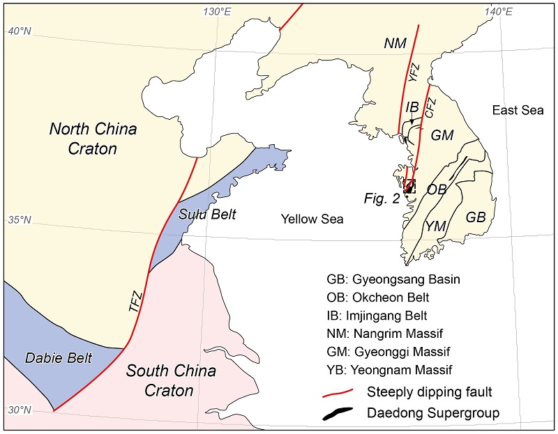
General tectonic setting of the Mesozoic Daedong Supergroup in South Korea ,modified from Cluzel (1992), Han et al. (2006), Choi et al. (2012), and Park et al. (2014b). It is notable that the Daedong Supergroup in the southwestern Korean peninsula is located in the southwesterly extension of the Chugaryeong fault zone which is a crustal scale strike-slip fault cutting through three different tectonic domains (viz. Gyeonggi massif, Imjingang belt, and Nangrim massif). A black dashed box is the area of Figure 2. Abbreviation, TFZ: Tan-Lu fault zone, YFZ: Yeseonggang fault zone, CFZ: Chugaryeong fault zone.
이러한 맥락에서 본 연구는 충남분지에 발달하는 지질구조의 지층 규제 양상에 대한 연구의 일환으로 수행되었다. 충남분지는 대동누층군이 가장 넓게 분포하는 지역으로 근래 구조지질학적, 퇴적학적, 암석학적, 연대지질학적 측면에서 활발하게 연구가 진행된 곳이다(e.g., Egawa et al., 2006, 2008, 2009, 2011; Jeon et al., 2007; Lim and Cho, 2012; Egawa, 2013). 본 연구에서는 충남분지 서부 오서산 지역에 대한 지표 조사 및 구조 해석을 수행하였으며, 이를 통해 새로운 단층을 정의하고 장산단층이라 명명하였다. 분지의 구조역전(structural inversion)에 수반된 단경단층(shortcut fault) 및 분리단층(detachment fault)으로서 발달한 것으로 해석되는 장산단층의 존재는 분지 형성이 인장환경에서 이루어 졌음을 지시할 수 있으며, 그간 충남분지에서 수립되었던 층서 체계에 대한 재검토가 필요함을 암시한다. 연구 결과는 향후 충남분지를 형성·변형시킨 지구조 운동의 특성을 파악하고 분지 진화사를 복원하는데 매우 유용하게 활용될 수 있을 것으로 판단된다.
2. 지질개요
충청남도 보령 일대에 발달하는 충남분지의 기반암은 지질시대, 지구조 환경, 변성 및 구조 특성에 근거하여 크게 세 영역으로 구분된다(그림 2; Kim et al., 2014 and references therein). 가장 동쪽에 분포하는 영역 1은 고원생대 편마암으로 주로 구성되며, 신원생대 및 고생대의 염기성 화성 활동에 의해 영향을 받았다. 신원생대에 관입한 일부 변성염기성암 내에는 에클로자이트상 변성작용이 기록되어 있다(Oh et al., 2005; Kim et al., 2006; Kwon et al., 2009, 2013; Park et al., 2014b). 영역 2는 주로 신원생대 호 환경 화성활동과 고생대 호-전호 환경의 화산-퇴적 작용을 기록한다(Kim et al., 2008, 2013; Park et al., 2014a). 이중 변성 화산-퇴적암에서는 특징적으로 백립암상의 고생대 변성작용이 인지된다(Kim et al., 2011a, b). 영역 3에는 융기된 퇴적암 혹은 변성퇴적암에서 퇴적물이 유래한 후기 고생대 저탁암이 넓게 분포한다(Lim et al., 1999; Cho, 2007; So et al., 2013; Choi et al., 2014). 이 영역의 변성도는 녹색편암상에 해당한다(Na, 1992; Cho et al., 2010). 각 영역은 단층에 의해 서로 접촉한다. 영역 1과 2는 청라단층(Egawa and Lee, 2006), 영역 2와 3은 당진단층(Kihm et al., 2010)으로 각기 구획된다(그림 2).
충남분지는 성주, 오서산, 오천 지역으로 크게 분대된다(그림 2). 이들 지역의 분지 충전물은 각기 독립된 아분지(subbasin)에 퇴적된 것으로 해석되기도 하지만(e.g., Egawa and Lee, 2009; Egawa, 2013), 남포층군으로 동일하게 명명되어 왔다(Choi et al., 1987; Lim and Cho, 2012; Egawa and Lee, 2006, 2008, 2009; Egawa, 2013). 남포층군은 하부로부터 하조층, 아미산층, 조계리층, 백운사층, 성주리층으로 세분되며, 하천-삼각주-호수 환경에서 퇴적된 것으로 해석된다(Choi et al., 1987; Egawa and Lee, 2009). 이들 중 하조층, 조계리층, 성주리층은 주로 역암과 사암으로 구성되며, 아미산층과 백운사층은 사암 및 셰일로 이루어져 있다(Choi et al., 1987; Egawa and Lee, 2006). 남포층군의 퇴적시기는 고생물학적, 고지자기적 자료들을 근거로 후기 트라이아스기-전기 쥬라기로 제안되어 왔으나(e.g., Min et al., 1992; Chun et al., 1990), 근래 분지의 동측 연변부에 분포하는 화산쇄설암에서 약 172 Ma의 저어콘 SHRIMP U-Pb 연령(Koh, 2006)이 보고됨에 따라 전기-중기 쥬라기로 재해석되고 있다(e.g., Egawa and Lee, 2009; Lim and Cho, 2012). 하지만 본래 성주지역에서 정의된 남포층군 내에 화산쇄설암이 발달하지 않는 것을 고려하였을 때(Kim, 1976; Choi et al., 1987), 해당 화산쇄설암이 실제로 남포층군에 포함되는 것인지에 대한 여부 및 그 층서적 위치가 아직 불명확한 것이 사실이다.
충남분지 오서산 지역의 경우 하위에 유문암질-석영안산암질 화산쇄설암 및 응회암질 퇴적암이 넓게 분포하며, 그 상위로 성주지역 상부 남포층군(상부 조계리층, 백운사층, 성주리층)에 대비되는 지층들이 분포하는 것으로 알려져 있다(그림 2; Choi et al., 1987; Egawa and Lee, 2006, 2008, 2009; Kim et al., 2014). 초창기 Shimamura (1931)는 화산쇄설암을 남포층군을 관입한 백악기 석영 반암으로 분류하였고, 이후 일부 연구자들에 의해 그 시대 혹은 암상분류가 받아들여졌으나(e.g., Lee et al, 1996; Lim and Cho, 2012), Choi et al. (1987)과 Egawa and Lee (2006, 2008, 2009)는 화산쇄설암과 응회암질 퇴적암을 묶어 남포층군의 하부 단위(하조층, 아미산층, 하부 조계리층)와 대비시켰다. 이러한 해석은 근본적으로 오서산 지역에 분포하는 충남분지 퇴적층들이 역전되거나 단층에 의한 중첩 없이 본래의 층서적 관계를 유지하고 있다는 가정에서 비롯하였다. 하지만 후술할 내용과 같이 상부 남포층군과 화산쇄설암 및 응회암질 퇴적암 단위는 충상단층에 의해 접촉하고 있으며(그림 2∼4), 이는 현재까지 제시되어 왔던 충남분지 오서산 지역의 층서 체계가 새롭게 정립되어야함을 의미한다.
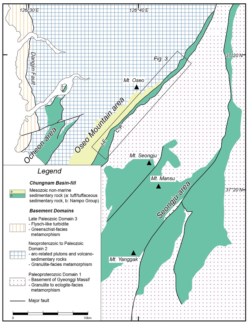
Simplified tectonostratigraphic map around the Chungnam Basin, modified from Shimamura (1931), Lee et al. (1996), Lim and Cho (2012) and Kim et al. (2014). The basement is divided into three domains, Paleoproterozoic domain ,Neoproterozoic to Paleozoic domain, and Late Paleozoic domain, all of which are bounded by major faults. The Chungnam Basin-fill is composed of isolated sediment packages as those in the Ocheon, Oseo Mountain, and Seongju areas. It is noteworthy that pyroclastic rock and tuffaceous sedimentary rock are widely distributed in the Oseo Mountain area. A black solid box is the area of Figure 3. Abbreviation, J.F.: Jangsan fault, C.F.: Cheongla fault.
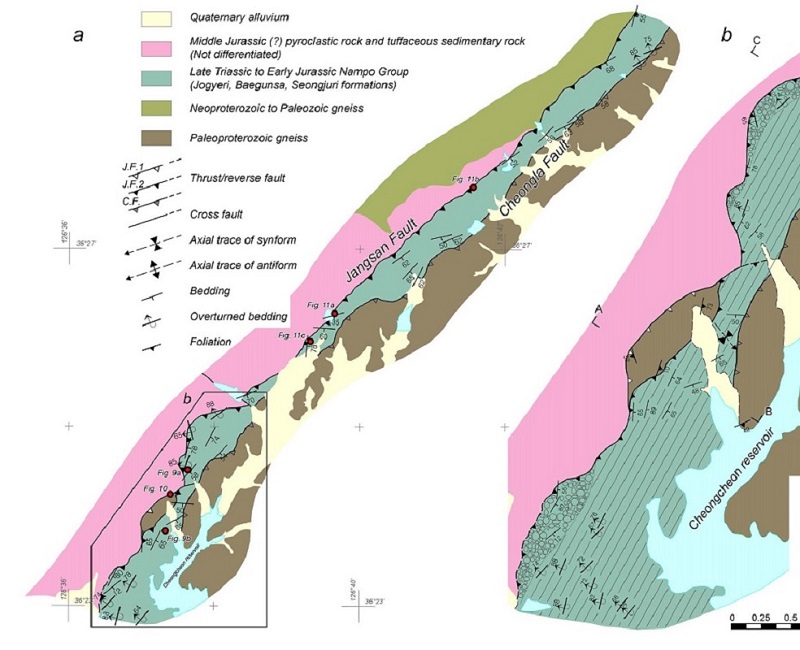
(a) New geologic map of the Jangsan Sheet. Red dots are the locations of following figures. (b) Detailed geologic map around the Cheongcheon reservoir where the Jangsan fault 1 and 2 are developed. Abbreviation, J.F.1: Jangsan fault 1, J.F.2: Jangsan fault 2. C.F.: Cheongla fault.
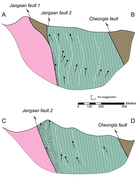
Cross sections of the Jangsan Sheet. The sections were drawn perpendicular to fold axis, based on down-plunge projection using surface bedding data. The projection axis for the sections A-B and C-D is 025°/17° and 036°/25°, respectively, that are selected from π-pole to fold (refer Figure 8). Black stick on the sections indicates projected bed attitude, and white dashed line means inferred bed trace. Lithologic symbols are adopted from Figure 3.
충남분지는 두 번의 압축변형을 경험한 것으로 알려져 있다(Cluzel, 1992; Lim and Cho, 1992; Kim, 1996). 변형작용의 시기 및 관련된 조산운동 종류에 대한 해석에 다소 차이는 있지만, 첫 번째 변형작용은 북서-남동 혹은 서북서-동남동 방향의 압축에 의한 북동-남서 혹은 북북동-남남서 방향의 충상단층과 습곡구조로 특징지어지는 반면 두 번째 변형작용은 남-북 방향의 압축에 의한 동-서 방향의 역단층 및 습곡구조로 정의되는 것으로 일관되게 해석되어지고 있다. 서로 다른 두 습곡의 중첩은 충남분지 내에 돔과 분지 구조(dome-and-basin structure)를 형성시켰다.
3. 장산단층
장산단층은 오서산 지역에 분포하는 유문암질-석영안산암질 화산쇄설암 및 응회암질 퇴적암과 상부 남포층군(조계리층, 백운사층, 성주리층)의 경계단층으로 정의된다. 장산단층에 의해 분포가 제어된 지층들의 특성, 단층 및 단층에 수반된 습곡의 기하학적 특성, 단층의 내부구조 양상을 정리하면 다음과 같다.
3.1 지층 규제 양상
단층의 남동측은 상부 남포층군(조계리층, 백운사층, 성주리층)에 해당하는 역암, 셰일, 사암이 분포한다(그림 2, 3). 특징적인 점은 단층과 인접하여 지표에 조계리층의 역암 혹은 역질 사암이 연장성 좋게 분포한다는 것이다. 역암은 대부분 중조립사 크기의 기질 내에 최대 4∼5 cm 크기를 가지는 원형∼아각형의 역들이 기질지지(matrix-supported) 또는 역지지된(clast-supported) 특징을 보인다(그림 5a). 역의 종류는 규암, 석영맥과 같은 석영질암이 지배적이며, 편마암, 사암, 이암, 화산암 또한 관찰된다. 역암 상위에는 회색∼암회색의 셰일이 주로 분포하며 세립∼조립 장석질 사암이 빈번하게 협재한다(그림 5b, 5c). 단층의 남동측에 분포하는 셰일에서 산출되는 식물화석은 성주 지역 남포층군에서 보고된 식물군과 잘 대비된다(Chun, H.Y., personal communication).
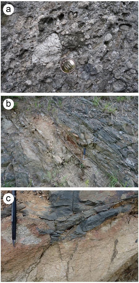
Outcrop photographs of main lithologies in the Jangsan Sheet. (a) Conglomerate of the Jogyeri Formation. (b) Dark gray shale of the Baegunsa Formation. (c) Load structure in the Baegunsa Formation. Upper dark gray shale is injected into lower sandstone indicating overturned sequence.
한편 청천저수지 북서쪽으로 장산단층에 수반되어 이동된 길이 약 1,300 m, 폭 약 300 m 크기의 고원생대 편마암체가 발달한다(그림 3). 암체 내부에는 퇴적암류에서는 관찰되는 않는 점착력을 가지는 단층각력암(cohesive fault breccia)이 빈번하게 발달한다(그림 6). 각력암 내부의 암편들은 파쇄작용(cataclasis)에 의해 깨지고 이동된 흔적을 간직한다. 하지만 단층각력암과 모암의 경계는 점이적이고 불규칙하며, 판상 단층대의 형태를 뚜렷하게 정의하기 어렵다.
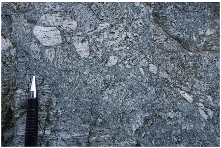
Outcrop photograph of cohesive fault breccia, pervasively developed in the Paleoproterozoic basement sliver which is cut and carried by the Jangsan fault 1.
단층의 북서측 지역에 분포하는 암종은 횡적으로 큰 차이를 보인다. 단층의 남서부에는 화산쇄설암 및 응회암질 퇴적암이 단층과 인접하여 넓게 분포한다(그림 2, 3). 화산쇄설암은 담회색-회색을 보이는 유리질 석기 내에 K-장석, 사장석, 석영 반정이 함유되어 있는 것이 특징이다(그림 7a). 이 암체는 대부분 괴상이나 국부적으로 층상구조를 보인다. 암편은 주로 유문암질 화산암류로 구성되며, 곳에 따라 편마암편 및 이암편이 관찰된다. 화산쇄설암은 대부분 화산력(lapilli)의 함량이 25% 미만으로 응회암(tuff)의 범주에 해당하나, 일부 화산력 함량이 높은 곳에서는 화산력 응회암(lapilli tuff) 혹은 화산역암(lapillistone)으로 분류되기도 한다. 응회암질 퇴적암은 주로 회색-암회색 셰일, 역암, 사암으로 구성된다(그림 7b). 셰일 내에는 슬럼프 구조, 정단층과 같은 퇴적 동시성 구조가 발달하며(그림 7c), 곳에 따라 응회암이 얇게 협재하기도 한다. 해당 역암의 경우 단층의 남동측에 분포하는 조계리층 역암에 비해 원마도가 불량하고 입도가 크다. 특히 기반암과의 부정합면 주변에 분포하는 역암은 특징적으로 대력(cobble) 이나 거력(boulder)을 포함하기도 한다(그림 7d). 역의 종류는 화강암이나 편마암이 지배적이다. 응회암질 퇴적암 내에서 산출되는 식물화석은 Ruffordia sp., Coniopteris concinna, Sphenopteris sp., Carpolithus sp. 등이 있으며, 이는 남포층군에서 그간 보고되어 왔던 식물군과는 차이를 보인다(Hong, P.S. and Chun, H.Y., personal communication).
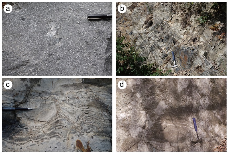
Outcrop photographs of main lithologies in the footwall of the Jangsan fault. (a) Massive rhyolitic to dacitic tuff. (b) Dark gray tuffaceous shale. (c) Tuffaceous shale layer disrupted by chaotic fold and normal fault possibly as slump structures. (d) Boulder conglomerate showing angular to subangular clasts composed dominantly of gneiss and granite.
화산쇄설암 및 응회암질 퇴적암이 북동쪽으로 갈수록 첨멸하면서, 단층의 북서측을 이루는 암종은 신원생대-고생대 편마암으로 변한다. 편마암은 주로 화성암 기원으로, 변성돌러라이트과 변성화강섬록암이 주를 이룬다(Kim et al., 2014).
3.2 장산단층 및 상반 습곡의 기하학적 특성
장산단층은 전반적으로 북북동-남남서∼북서-남동 방향의 주향을 가지며, 경사방향은 남동쪽을 향한다(그림 2∼4). 이는 상술한 단층의 남동측 지역과 북서측 지역이 각기 상반과 하반에 해당함을 의미한다. 이 단층은 청천저수지 인근에 발달하는 렌즈상 편마암체를 기준으로 두 개의 단층(장산단층 1, 2)으로 구분된다(그림 3). 지층 분포 정보(그림 3b)와 하향 투영법(down-plunge projection)으로 작성된 단면도(그림 4)를 통해 인지할 수 있듯이, 장산단층 1은 기반암을 잘라 응회암 상위로 이동시킨 고각의 단층이며, 장산단층 2는 역암, 사암으로 주로 구성된 조계리층에 위치한 저각(지층에 아평행)의 분리단층(detachment fault: Butler, 1982; McClay, 1992)이 셰일, 사암으로 주로 이루어진 백운사층을 통해 램프의 형태로 전파(ramp up)된 충상단층이다.
장산단층 2의 상반에는 두 조의 습곡 구조(Fa, Fb: 발달 순서와 무관)가 발달한다. 층리 자세의 공간적인 변화 양상을 고려하여 적절하게 영역을 나눈 후 평사 투영 해석을 수행하면 두 조의 습곡 구조 발달이 더욱 명확하게 인지된다(그림 8). Fa는 완만형(gentle) 내지는 개방형(open)의 횡와습곡(recumbent fold) 혹은 완사습곡(gently inclined fold) 형태를 보이며, 힌지는 단층과 평행한 북북동 내지는 북동 방향으로 완만하게 침강한다(gently plunging). 습곡의 두 날개는 각기 남동쪽과 북서쪽으로 경사하는데, 이 중 북서쪽으로 경사하는 날개는 역전되어 있다(그림 3). Fb는 완만형(gentle) 내지는 개방형(open)의 급경사습곡(steeply inclined fold)의 형태를 보인다. 이 습곡의 힌지는 남남동 내지는 남쪽 방향으로 단층에 사교하며 중침강(moderately plunging)한다. Fa는 장산단층 1, 2의 상반에서 각기 남서측 영역에 해당하는 영역 1-1과 영역 2-1에서 뚜렷하게 정의되는 반면, Fb는 북서측 영역인 영역 1-2와 영역 2-2에서 잘 인지된다(그림 8). 이들 습곡에서 주목할 만한 공간기하학적 특성은 노두규모 혹은 미세규모에서는 해당 습곡의 형태가 잘 관찰되지 않는다는 점이다. 이는 광역 습곡에 수반된 기생습곡(parasitic fold)의 발달정도가 미약함을 의미하며, 그림 8에서 보이는 바와 같이 서로 다른 영역에서 획득한 지층 방향 자료의 평사 투영 해석 결과가 뚜렷하게 차이를 보이는 이유이다. 또한 이들 습곡은 벽개면을 광역적으로 수반하지는 않는다. 비록 일부 노두에서 첫 번째 습곡에 수반된 저각의 벽개면이 관찰되기는 하지만(그림 9), 전반적으로 벽개면의 발달 빈도는 매우 낮다. Fa, Fb 습곡의 형태가 모두 완만하고 기생습곡의 발달정도가 미약함에 따라 상호 간섭 형태(interference pattern: Ramsay, 1967)가 뚜렷하게 인지되지 않는다. 이와 더불어 두 습곡 모두 면구조의 형성을 잘 수반하지 않기 때문에 구조 요소의 간섭 현상을 통해 해당 변형의 상대적 순서를 파악하기란 사실상 어렵다.
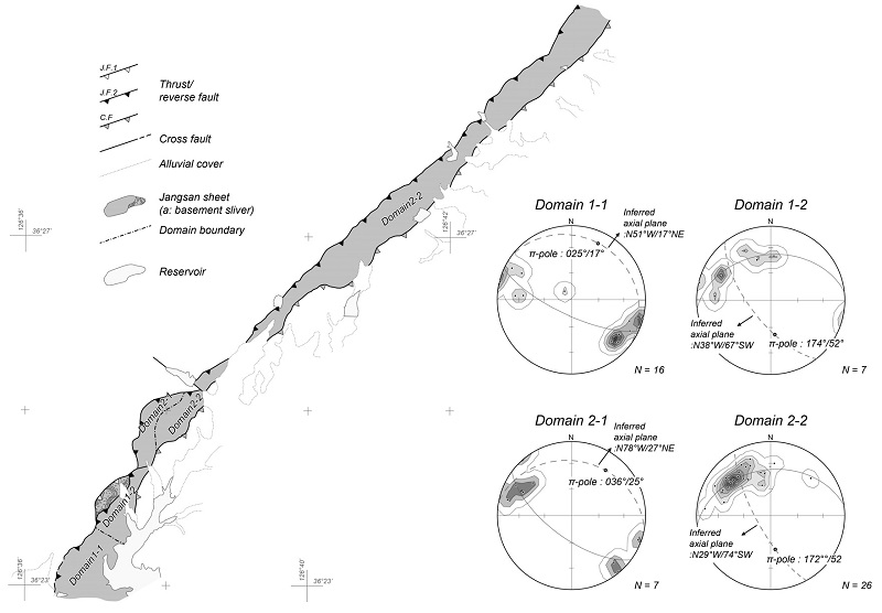
Equal area stereographic projection of pole to bedding within the Jangsan Sheet. Four domains are divided based on spatial variation of bedding attitude. Fold hinge inferred from π-pole plunges toward NNE in the domains 1-1 and 2-1, while southward in the domains 1-2 and 2-2. Abbreviation, J.F.1: Jangsan fault 1, J.F.2: Jangsan fault 2. C.F.: Cheongla fault.
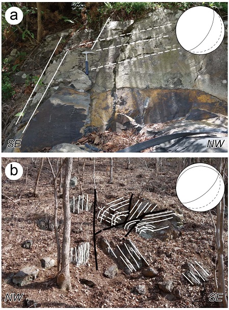
Outcrop photographs showing a bedding-cleavage relationship (The locations are marked in Figure 3). Soild line is bedding trace and dashed line is cleavage trace (a) Bedding is higher than cleavage in dip angle. The cleavage is interpreted to be formed in association with Fa fold. (b) A gently dipping Fa fold with NE-plunging hinge and related axial plane cleavage. Note that the fold is developed on a low-angle fault.
3.3 장산단층의 내부 구조
그림 10a는 장산단층 1의 노두로서 단층을 기준으로 남동측의 고원생대 편마암과 북서측의 응회암이 서로 맞닿고 있는 양상을 보인다. 상반에는 점착력을 가지는 단층각력암(cohesive fault breccia)이 발달하고 있는데, 모든 암편은 원암인 편마암으로 구성된다(그림 10b). 단층각력암은 괴상이며 내부에는 운동학적 특성을 파악할 수 있는 비대칭 구조가 관찰되지 않는다. 이는 위치에 상관없이 편마암체 내부에 빈번하게 발달하는 단층각력암(그림 6)과 그 특성이 유사하다. 이에 반해 하반에는 엽리상 파쇄암(foliated cataclasite)이 분포한다(그림 10c). 엽리상 파쇄암의 발달은 단층면에서 약 1 m 이내의 구간에 국한된다. 엽리상 파쇄암의 기질은 세립의 석영, 견운모, 백운모 등으로 구성된다. 암편은 각형 혹은 아각형의 석영 및 장석 입자, 그리고 편마암으로 이루어져 있는데, 편마암편은 파쇄작용 도중 상반 암체에서부터 유래한 것인지 혹은 원암인 응회암에 함유되어 있던 암편 인지 명확하게 파악할 수 없다. 일부 편마암편을 제외하고 구성 광물 대부분은 균질소광(uniform extinction) 혹은 미약한 파동소광(weak undulatory extinction)을 보인다. 더불어 아입자(subgrain), 재결정된 입자(recrystallized grain) 등 입자 규모의 소성변형(plastic deformation)을 지시하는 증거들은 잘 관찰되지 않는다. 대신 암편 내부 균열이 빈번하게 관찰되며 이를 따라 조각난 파편이 이동하고 회전한 증거들이 관찰된다. 엽리면은 암편 및 운모류의 정향배열에 의해 정의되는데, 이에 아평행 혹은 사교하며 압력용해선(pressure solution seam)이 단속적으로 발달한다(그림 10c). 엽리상 파쇄암은 원암인 괴상의 응회암(그림 10d)으로 점이한다.
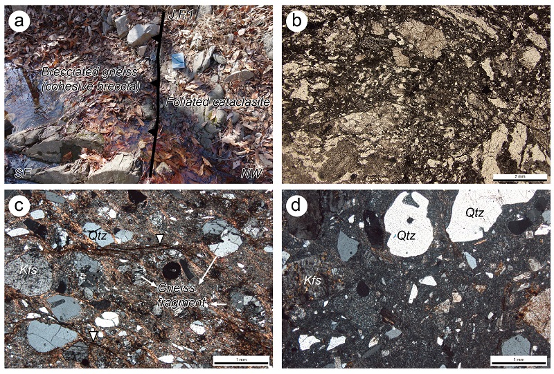
(a) Outcrop photograph of the Jangsan fault 1 (The location is marked in Figure 3). The Jangsan fault 1 is defined by high-angle contact between gneiss southeasterly and tuff northwesterly. The fault zone is composed of cohesive fault breccia and foliated cataclasite. The fault breccia is similar to that shown in Figure 6 in characteristics. The foliated cataclasite has a width beneath approximately 1 meter, and changes gradually into massive tuff. (b) Photomicrograph of the cohesive fault breccia (open-polarized light), (c) Photomicrograph of the foliated cataclasite (cross-polarized light). Sericite-bearing foliation is cut by pressure solution seams which partly accommodate slip (white triangles). (d) Photomicrograph of massive tuff as a protolith of the foliated cataclasite (cross-polarized light).
상술한 단층노두에서는 몇 가지 중요한 정보를 얻을 수 있다. 첫째로 단층각력암이 장산단층 1의 근접구간 뿐만 아니라 편마암체 내부에 빈번하게 발달되어 있으며 분지충전물 내부에는 관찰되지 않기 때문에, 기원적으로 장산단층 1의 발달 이전에 이미 형성된 상속구조(inherited structure)에 해당할 수 있다. 즉 장산단층 1이 기존에 형성되어 있던 기반암 내 단층각력암을 절단하고 있는 양상(그림 10a)은 렌즈상의 편마암체가 상속된 약대(inherited weak zone)를 따라 절단되어 단층에 병합되었을 가능성을 지시한다. 둘째로 엽리상 파쇄암의 경우 단층 주변에 국한되어 발달되기 때문에 장산단층 1과 기원적으로 밀접한 관련성을 가진다. 입자 규모의 소성 변형 증거가 미약하고 암편 내부 균열 및 압력용해선이 발달하는 양상은 단층암의 형성 기작으로 파쇄작용(cataclasis) 및 유체에 의해 촉진되는 확산작용(fluid-assisted diffusion)이 우세하게 작용하였음을 지시한다(Passchier and Trouw, 2005). 운모류의 성장 및 엽리면의 발달은 유체에 의해 촉진되는 확산작용에 의해 제어되고 단층암의 연화작용(softening)을 야기했을 가능성이 높다(Evans and Chester, 1995; Jefferies et al., 2006). 마지막으로 접착력이 있는 엽리상 파쇄암이 응회암 내부에 발달되어 있음은 응회암이 최소 약 4 km 이상 깊이까지 매몰되었음을 의미한다(Twiss and Moores, 2007).
장산단층 1의 노두에서는 물질의 이동 방향을 지시하는 선구조가 명확하게 인지되지 않는다. 일부 변위를 보이는 압력용해선 및 이를 따른 엽리면의 휨현상이 현미경 하에서 관찰되기는 하나, 단층 운동 방향이 명확하지 않아 체계적인 운동학적 해석을 수행하기에는 무리가 있다. 다만 응회암 상위에 구조적으로 기반암이 놓이는 점은 장산단층 1의 운동이 적어도 역경사이동 성분을 우세하게 가짐을 간접적으로 지시한다.
한편 남포층군의 조계리층(혹은 일부 백운사층)을 응회암 혹은 기반암과 병치시키는 장산단층 2의 노두에서는 운동학적 특성이 비교적 명확하게 인지된다. 그림 11에서 보이는 바와 같이 장산단층 2의 직상부에는 손상대(damage zone)에 해당하는 변형 집중 구간이 발달한다(그림 3에서 노두 위치 참조). 비록 노두 발달이 제한적이어서 응회암과 남포층군의 접촉구간(단층핵) 자체는 관찰되지는 않으나, 손상대 내부에는 대략 북서쪽으로 상단 절단(cut up section)하는 저각의 단층들이 일관되게 발달한다. 이들 단층들은 주로 각력암, 단층점토와 같은 점착력이 없는 단층암(incohesive fault rock)으로 채워져 있어, 상술한 장산단층 1의 단층대보다는 비교적 얕은 깊이에서 형성되었음을 가정할 수 있다. 하지만 단층핵을 직접적으로 관찰하지 못한 상태에서 장산단층 2가 장산단층 1과 같이 초기에는 비교적 깊은 깊이에서 형성된 단층인지 혹은 처음부터 얕은 깊이에서 형성된 단층인지는 명확하지 않다. 다만 확실한 것은 장산단층 2는 조계리층을 응회암 혹은 기반암 상위로 충상시켜 현재의 지층 분포 양상을 가장 크게 제어한 단층이라는 것이다.
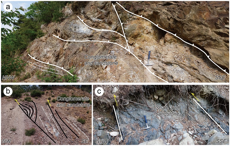
Outcrop photographs of damage zone of the Jangsan fault 2 (the locations are marked in Figure 3). Thrusts with top to the NW to NNW sense of movement are frequently developed in the damage zones. (a) and (b) show thrusts developed in competent conglomerate and sandstone layers, while (c) in incompetent shale and intercalated sandstone layers. Gray dashed line means bedding trace.
4. 해석: 형성 모델
4.1 습곡 형성 모델
장산단층 2의 상반에 발달하는 습곡의 기원을 단층의 운동과 연관해 살펴보면, Fa의 경우 방향성의 평행함에 근거하여 장산단층 2의 충상운동에 수반된 것으로 판단된다. 충상운동과 관련하여 생성될 수 있는 주된 단층 수반 습곡(fault-related fold)의 종류로는 단층 전파 습곡(fault-propagation fold), 단층 요굴 습곡(fault-bend fold), 그리고 분리습곡(detachment fold)이 있다(그림 12: Brandes and Tanner, 2014, and references therein). Fa는 1) 분리단층의 특성을 보이는 장산단층 2의 직상부에 발달하고, 2) 습곡의 형태가 대칭에 가까우며, 3) 습곡축면이 단층과 고각을 이루는 점으로 미루어 보아(그림 4) 분리습곡으로서 발달된 것으로 해석된다(Jamison, 1987; Mitra and Namson, 1989; Poblet and Hardy, 1995; Hardy and Finch, 2005). 더불어 북북동 혹은 북동 방향의 습곡 형태를 고려하였을 때, 본 습곡 및 이와 관련된 충상단층은 기존 연구자들에 의해 제시된 충남분지에서의 첫 번째 압축변형작용의 산물(Cluzel, 1992; Kim, 1996; Lim and Cho, 2012)에 대비된다.
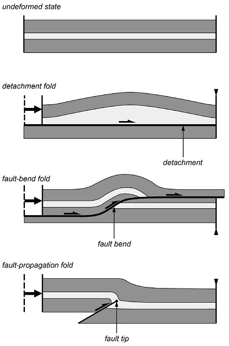
Schematic diagram showing geometry and mechanism of representative fault-related folds (detachment fold, fault-bend fold, and fault-propagation fold), adopted from Brandes and Tanner (2014).
반면 Fb의 경우 축면의 지표 궤적이 단층의 방향과 고각을 이루는 점을 바탕으로 일종의 교차습곡(cross fold)으로 분류될 수 있다. 충상단층이 전파될 때 융기된 기반암과 같은 장애물과 부딪침으로 인해 부분적으로 교차습곡이 형성될 수도 있지만(Yonkee et al., 2013), 연구지역처럼 단층의 연장을 따라 해당 습곡이 비교적 연속적으로 발달되고 있는 상황에서는 이러한 기작을 습곡의 형성 원인으로 적용하기 어렵다. 다만 장산단층이나 청라단층의 궤적이 Fb에 의해 교란 받지 않은 점(그림 3)은 습곡의 형성이 이들 단층의 활동과 동시기(충상운동 제외) 혹은 그 이전에 이루어졌음을 의미할 수 있다. 이러한 조건 안에서 가능한 습곡의 형성 모델로는 1) 분지 형성과 관련하여 전달인장(transtension)에 의해 발달된 습곡(e.g., Fossen, 2013; Venkat-Ramani and Tikoff, 2002), 2) 충상단층의 주향이동단층으로의 재활성에 수반된 습곡(e.g., Lim and Cho, 2012) 등이 있다. 하지만 연구지역에서 획득한 한정된 자료를 통해서는 Fb의 형성 원인을 명확하게 파악하기 어렵다. 한편 이 습곡은 기존 연구자들에 의해 두 번째 압축변형작용의 산물로 제시된 동-서 방향의 습곡과는 큰 차이를 보인다. 이러한 배경에서 Fb 습곡의 상대적인 발달 시기 및 발달 기작을 규명하기 위해서는 추후 성주지역과 오천지역에 분포하는 남포층군의 구조 요소에 대한 종합적인 검토가 필요하다.
4.2 장산단층 형성 모델
장산단층의 형성 모델을 수립하기 위해서는 우선 단층의 특성에 대한 몇 가지 의문점에 대해 고민해 보아야 한다. 1) 장산단층 1의 상반(장산단층 2의 하반)에 분포하는 고원생대 편마암체 조각(sliver)의 경우 어떠한 기작으로 절단되어 이동하였는가? 2) 일반적으로 분리단층이 셰일, 암염, 석고 등과 같은 역학적 약대를 따라 발달한다는 점을 고려할 때(e.g., Davis and Engelder, 1985; Echavarria et al., 2003; Nilfouroushan et al., 2013), 분리단층으로서 장산단층 2가 어떻게 역학적 강도가 상대적으로 높은 역암 및 사암 우세대에 발달할 수 있는가? 3) 장산단층 2의 북동쪽 연장을 따르면 하반을 구성하는 암종이 화산쇄설암 및 응회암질 퇴적암에서 신원생대-고생대 편마암류로 변화하는데, 이 구간에서 젊은 퇴적암이 오래된 기반암 상위로 충상하는 현상은 어떻게 설명할 수 있는가?
첫 번째 의문점과 관련하여 충상단층 혹은 역단층에 의해 기반암이 변형될 수 있는 대표적인 경우를 나열하면 다음과 같다(그림 13). 1) 분리단층이 기반암 내부에 발달되는 경우(그림 13a: e.g., Lacombe and Mouthereau, 2002; Butler et al., 2006), 2) 고각의 정단층이 역단층으로 역전(inversion)되면서 기반암 전체가 융기되는 경우(그림 13b: e.g., McClay and Buchanan, 1992; Coward, 1994), 3) 고각의 정단층이 역단층으로 역전(inversion)되면서 기반암의 일부가 절단되어 이동되는 경우(그림 13c: e.g., McClay and Buchanan, 1992; Coward, 1994), 4) 기반암-퇴적암 경계면이 고각으로 변화해 이를 따르는 단층 경로의 단축 과정에서 기반암의 모서리가 절단되는 경우(그림 13d: e.g., Mitra, 1997) 등이다. 고각의 정단층이 역단층으로 역전되어 기반암 전체가 융기되거나 분리단층이 기반암 내부에 발달한다면, 단층에 의해 이동된 기반암의 분포 영역이 넓게 혹은 반복적으로 분포해야 하며 관련된 충상단층이나 역단층이 상단 절단(cut up section)의 원칙을 따라야 한다. 하지만 렌즈상의 기반암체가 국부적으로 발달하며 하단 절단(cut down section)의 특징을 보이는 것으로 보아 연구지역에서 기반암이 절단되어 이동된 원인으로 첫 번째나 두 번째 경우보다는 세 번째나 네 번째 경우를 고려하는 것이 합리적이다. 만약 네 번째 경우 고각의 기반암-퇴적암 경계면을 정단층과 같은 기존의 분지 제어 단층으로 해석한다면, 결국 렌즈상의 기반암체는 장산단층 1의 후피변형(thick-skinned deformation) 혹은 박피변형(thin-skinned deformation) 과정에서 분지 제어 단층의 하반이 붕괴되었음을 의미한다. 분지 확장 시 형성된 고각의 단층이 향후 충상단층 혹은 역단층으로 재활성 되는 과정에서 하반이 붕괴되어 절단되는 현상은 알프스 조산대(e.g., Coward, 1994), 코디에란 조산대(e.g., Mora et al., 2006; Carrera and Munoz, 2008), 피레니안 조산대(e.g., Saura and Teixell, 2006) 등지에서 빈번하게 인지되며, 이러한 특성을 보이는 단층은 단경단층(shortcut fault: Hayward and Graham, 1989; McClay and Buchanan, 1992; Bonini et al., 2012)으로 표현된다. 단경단층은 일반적으로 확장성 분지(extensional basin)의 구조역전(structural inversion)에 대한 중요한 증거로서 받아들여진다(Hayward and Graham, 1989). 이러한 관점에서 렌즈상 편마암체 내부에 빈번하게 발달하는 단층각력암(그림 6, 10b)은 분지 형성 시 확장성 단층운동과 관련하여 발생되었을 가능성이 매우 높다.
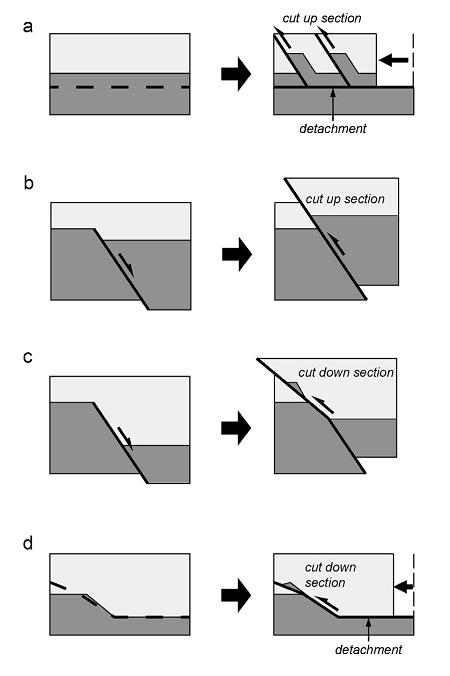
Schematic diagram showing possible mechanisms of basement-involved thrust(or reverse fault) in sedimentary basin. Dark gray domain is basement while light gray sedimentary cover. (a) Thin-skinned basement thrust on a detachment fault. (b) Thick-skinned reverse fault inverted from a high-angle normal fault. (c) Shortcut fault cutting through basement ramp during inversion of a high-angle normal fault in thick-skinned style. (d) Shortcut fault cutting through a high-angle basement ramp during thin-skinned deformation.
한편 지각의 변형은 역학적인 이방성(anisotropy) 및 이질성(heterogeneity)에 크게 좌우된다. 특히 비교적 균질한 기반암 상위에 이방성이 크고 불균질한 퇴적층이 팬케이크처럼 쌓여있는 경우 주변 지층에 비해 강도가 낮고 이방성이 큰 층준에 변형이 집중되는 경향이 있다(Teixell and Koyi, 2003). 하지만 퇴적층 내부의 역학적 약대를 고려하기 이전에 변형의 집중 구간으로 예측될 수 있는 곳이 바로 기반암과 퇴적층의 경계이다. 실제로 확장성 혹은 압축성 변형대에서 바닥의 분리단층(basal detachment fault)은 주로 기반암과 퇴적층의 경계에 발달한다(e.g., Mitra, 1997; Pfiffner, 2006; Collittini, 2011). 앞서 제시한 두 번째 의문점은 바로 이러한 현상에 근거하여 해결된다. 즉 장산단층 2는 박피변형(thin-skinned deformation) 과정에서 기반암과 그 상위에 퇴적된 조계리층의 경계를 따르는 분리단층으로서 형성되었다고 해석된다.
마지막으로 세 번째 의문점은 앞서 해석한 내용에 의해 자연스럽게 해결된다. 즉 기존의 분지 제어 단층을 따라 충상단층이 형성되는 경우 분지 경계에서 젊은 퇴적암이 오래된 기반암 상위로 충상하는 현상은 무리 없이 받아들여진다.
결론적으로 장산단층 1과 2는 인장 분지의 역전 과정에서 형성된 것으로 해석되며, 충남분지의 형성을 제어한 확장성 단층이 후기 압축변형작용 시 구조 발달을 제어했음을 나타내는 예라 할 수 있다. 하지만 장산단층 1이 장산단층 2와 같이 박피변형 과정에서 형성된 것인지 혹은 독립적으로 후피변형을 통해 형성된 후 장산단층 2과 연결되어 현재의 기하학적 특성을 보이는 것인지는 현재로서 명확하게 설명할 수 없다. 장산단층의 시·공간적인 진화에 관한 좀 더 정교한 모델을 수립하기 위해서는 분지 전체 규모의 종합적인 해석이 향후 수행되어야 한다.
5. 토 의
5.1 충남분지의 형성
앞서 기술한 장산단층의 형성 모델은 이 단층이 분지의 구조역전(structural inversion) 과정에서 형성되었음을 설명한다. 이는 충남분지의 형성이 인장환경에서 정단층에 의해 제어되었음을 지시하는 것이다. 다만 이러한 인장환경이 판 내부의 광역적인 변형조건을 대변하는 것인지 혹은 주향이동단층에 의해 국부적으로 야기되는 변형조건을 의미하는지는 현재로서는 명확하게 이야기할 수 없다. 한 가지 주의 깊게 살펴보아야 할 사항은 장산단층을 비롯한 충남분지 내 주된 단층들(Lee et al., 1996)이 한반도에서 가장 규모가 큰 주향이동단층대 중 하나인 추가령 단층대(Chwae, 1998; Choi et al., 2012; Song et al., 2014)의 연장과 거의 일치한다는 점이다(그림 1). 이는 충남분지의 진화가 이들 단층대의 운동과 밀접하게 연관되었을 가능성을 지시한다. 실제 일부 연구자들은 충남분지를 비롯한 한반도 서부지역 중생대 퇴적분지의 형성이 추가령 단층대와 예성강 단층대를 포함한 추가령 단층계의 운동에 수반되었음을 주장한바 있다(e.g., Cluzel et al., 1992; Choi et al., 2012). 하지만 이러한 가능성을 좀 더 명확하게 규명하기 위해서는 향후 체계적인 구조지질학적, 퇴적층서학적, 연대지질학적 접근이 필요하다.
충남분지가 인장환경에서 형성되었다는 생각은 근래 충남분지에서 제시되었던 분지형성모델과는 차이를 보인다. Egawa and Lee (2009), Egawa (2013)는 충남분지를 후호 지역의 쐐기상부분지(wedge-top basin) 혹은 목말분지(piggyback basin)로 해석하였다. 이러한 해석은 1) 충남분지에서 보고된 약 172 Ma의 저어콘 U-Pb 연대(Koh, 2006)가 분지의 형성시기를 대변하며 그간 알려져왔던 대보조산운동의 지속기간에 부합한다는 생각과 2) 충남분지 퇴적층의 분포를 제어한 주된 충상단층의 이동 방향이 쥬라기 고태평양판의 섭입 방향과 유사한 북서 방향이라는 조사 결과에 기반을 둔다. 하지만 이러한 모델이 지지되기 위해서는 설명되어야 하는 몇 가지 사항들이 있다. 첫째로는 쐐기상부분지 혹은 목말분지가 전대륙 분지(foreland basin) 중 하나의 퇴적대(depozone)에 해당함을 고려하였을 때(DeCelles and Giles, 1996), 전대륙 분지의 다른 퇴적대(foredeep, forebulge, back-bulge depozones)를 대변하는 지층들이 왜 발달하지 않는 것인지, 둘째로 충남분지의 형성시기로 제시된 전기-중기 쥬라기에 분지 주변이 대륙호(continental arc)에 위치하고 있었음을 고려할 때(Sagong et al., 2005; Park et al., 2009; Kim et al., 2015), 후대륙(hinterland)에 해당하는 호 내부에서 전대륙 분지가 어떻게 형성될 수 있는 것인지, 마지막으로 전대륙 분지에 퇴적물을 공급한 후대륙 방면의 단층습곡대는 어디에 존재하는지가 바로 그것이다. 결론적으로 본 논문은 충남분지가 인장환경에서 정단층 발달에 수반되어 형성되었음을 제안하며, 압축환경에서 형성된 동시조산성 퇴적층이라는 일부 모델에 대한 재고가 필요함을 지적하고자 한다.
5.2 오서산 지역 충남분지의 층서 체계: 새로운 지층군 정의의 필요성
오서산 지역 충남분지에는 성주지역이나 오천지역에서 보고되지 않은 화산쇄설암 및 응회암질 퇴적암이 넓게 분포한다(그림 2, 3). 화산쇄설암 및 응회암질 퇴적암은 기존 연구자들에 의해 하부 남포층군(하조층, 아미산층, 하부 조계리층)과 대비되는 것으로 간주되어 왔다(e.g., Choi et al., 1987; Egawa and Lee, 2006, 2008, 2009; Egawa, 2013). 이러한 해석은 화산쇄설암 및 응회암질 퇴적암이 그 상위에 분포하는 상부 남포층군(상부 조계리층, 백운사층, 성주리층)과 부정합적인 관계에 놓여 있다는 가정에서 비롯하였다. 하지만 Egawa and Lee (2008)는 사암에서 추출한 일라이트 결정도(illite crystallinity)가 두 단위 사이에서 급격하게 변화한다는 사실을 보고하였고, 이후 Egawa (2013)는 이러한 자료를 설명하기 위해 두 단위가 단층에 의해 접촉되어 있음을 개념적인 삽도를 통해 암시한 바 있다. 그럼에도 불구하고 이들 연구 역시 기존 층서 체계 아래에서 단층의 실체를 제시하지 못하였다.
본 연구에서는 오서산 지역에 분포하는 화산쇄설암 및 응회암질 퇴적암과 상부 남포층군의 경계단층으로서 장산단층을 정의하였다. 장산단층의 존재에 따라 오서산 지역 충남분지를 이루는 모든 지층이 본래의 층서적 관계를 유지하고 있다는 가정은 더 이상 유효하지 않다. 이는 식물 화석 자료에 의해서도 지지된다. 앞서 언급한 응회암질 퇴적암에서 산출되는 식물화석 중 Coniopteris concinna는 중국, 시베리아 등지에서 중기 쥬라기-전기 백악기에 번성한 것으로 알려져 있으며(Chen et al., 1990; Hong, P.S. and Chun, H.Y., personal communication), 이를 포함한 식물군은 남포층군에서 기존에 보고된 후기 트라이아스기-전기 쥬라기의 Dictyophyllum-Clathropteris 식물군보다는 번성 시기가 더 젊은 것으로 받아들여질 수 있다. 고생물학적인 자료는 단층의 하반에 분포하는 지층의 형성시기가 상반 지층의 형성시기보다 젊다는 것을 의미하므로 구조지질학적인 해석과 조화롭다. 결론적으로 저자는 장산단층의 하반에 넓게 분포하는 화산쇄설암 및 이와 관련된 응회암질 퇴적암을 남포층군에서 제외시켜야 하며 독립적인 지층군으로서 새롭게 정의할 필요가 있음을 제안한다. 이러한 관점에서 Koh (2006)에 의해 제시된 약 172 Ma의 저어콘 SHRIMP U-Pb 연령이 과연 남포층군의 퇴적 시기를 대변하는지 신중하게 생각해 보아야 한다. 분석된 화산쇄설암이 충남분지의 동측 연변부에 분포하는 양상(Koh, 2006)은 이 암체가 전체 분지 충전물 중 층서적으로 상위에 위치함을 의미하며 연구 지역의 화산쇄설물과 대비될 수 있는 가능성을 결코 배재할 수 없다. 이러한 가능성을 시험하기 위해서는 후속 연구로서 오서산 지역에 분포하는 화산쇄설암에 대한 정밀한 절대연령측정이 필요하다.
충남분지의 층서 체계 재검토가 중요한 이유는 이러한 정보가 결국 충남분지를 교란시킨 변형사건의 시기 해석과 밀접하게 관련되어 있기 때문이다. 충남분지의 변형을 야기한 조산운동의 시기 및 특성을 정확하게 파악하기 위해서는 새로운 지층군의 명확한 정의 및 연대 측정, 그리고 정밀한 지질구조 해석이 반드시 선행되어야 한다.
6. 결 론
본 연구에서는 오서산 지역 충남분지에 발달하는 새로운 단층을 보고한다. 장산단층이라 명명된 이 단층은 남동측의 상부 남포층군(조계리층, 백운사층, 성주리층)과 북서측의 화산쇄설암 및 응회암질 퇴적암 사이의 경계단층으로 정의된다. 장산단층은 절단된 렌즈상의 기반암체를 기준으로 장산단층 1과 장산단층 2로 나뉜다. 장산단층 1은 기반암을 잘라 북서측 응회암 상위로 이동시킨 고각의 단층이며, 단경단층의 성격을 가진다. 장산단층 2는 역암, 사암으로 주로 구성된 조계리층에 위치한 저각의 분리단층이 셰일, 사암으로 주로 이루어진 백운사층을 통해 램프의 형태로 전파된 충상단층이다. 장산단층 2는 횡적으로 오래된 기반암 상위에 젊은 남포층군을 충상시키는 특성을 보인다. 이러한 특성을 보이는 장산단층 2는 단경단층의 특성을 보이는 장산단층 1과 함께 충남분지 구조역전의 증거로서 받아들여질 수 있다. 본 연구 결과는 충남분지가 압축환경 보다는 인장환경에서 정단층에 의해 제어되어 형성되었음을 제안한다. 다만 이러한 인장환경이 판 내부의 광역적인 변형조건을 대변하는 것인지 혹은 주향이동단층에 의해 국부적으로 야기되는 변형조건을 의미하는지는 좀 더 논의해야 할 사안이다. 한편 본 구조해석에 따르면 단층 하반에 분포하는 화산쇄설암 및 응회암질 퇴적암을 남포층군보다 젊은 새로운 지층군으로 재정의해야 할 필요성이 대두된다. 이는 충남분지 층서 체계의 재정립이 필요함을 의미한다.
Acknowledgments
이 논문은 한국지질자원연구원의 주요사업인 ‘한반도 중서부의 층서지구조 규명 및 통합지질정보시스템 구축(15-3111)’에 의해 지원되었다. 식물화석 동정과 관련하여 유익한 정보를 주신 한국지질자원연구원 전희영 박사님과 홍발 박사님께 감사드리며, 논문의 질적 향상을 위해 세심하고 건설적인 비평을 해주신 한국지질자원연구원 김유홍 박사님, 익명의 심사위원님, 그리고 편집위원님께 깊은 사의를 표한다.
References
-
Bonini, M., Sani, F., and Antonielli, B., (2012), Basin inversion and contractional reactivation of inherited normal faults: A review based on previous and new experimental models, Tectonophysics, 522-523, p55-88.
[https://doi.org/10.1016/j.tecto.2011.11.014]

-
Brandes, C., and Tanner, D.C., (2014), Fault-related folding: A review of kinematic models and their application, Earth-Science Reviews, 138, p352-370.
[https://doi.org/10.1016/j.earscirev.2014.06.008]

-
Butler, R.W.H., (1982), The terminology of structures in thrust belts, Journal of Structural Geology, 4, p239-245.
[https://doi.org/10.1016/0191-8141(82)90011-6]

- Butler, R.W.H., Holdsworth, R.E., and Matthews, S.J., (2006), Styles of basement involvement in the Moine Thrust Belt, NW Scotland, In: Mazzoli, S., and Butler, R.W.H. (eds.), Styles of Continental Contraction: Geological Society of America Special Paper, 414, p133-151.
-
Carrera, N., and Munoz, J.A., (2008), Thrusting evolution in the southern Cordillera Oriental (northern Argentine Andes): constraints from growth strata, Tectonophysics, 459, p107-122.
[https://doi.org/10.1016/j.tecto.2007.11.068]

- Chen, F., Li, C.-S., and Ren, S.-Q., (1990), ON CONIOPTERIS CONCICCA (HEER) comb. Nov, Palaeontographica Abteilung B, 216, p129-136.
- Cho, D.-L., (2007), SHRIMP zircon dating of a low-grade meta-sandstone from the Taean Formation: provenance and its tectonic implications, KIGAM Bulletin, 11, p3-14, (in Korean with English abstract).
- Cho, M., Na, J., and Yi, K., (2010), SHRIMP U-Pb ages of detrital zircons in metasandstones of the Taean Formation, western Gyeonggimassif, Korea: tectonic implications, Geosciences Journal, 14, p99-109.
- Choi, H.I., Kim, D.S., and Seo, H.G., (1987), Stratigraphy, Depositional Environment and Basin Evolution of the Daedong Strata in the Chungnam Coalfield: KR-87-(B)-3, Korea Institute of Energy and and Resources, p97, (in Korean with English abstract).
-
Choi, S.J., Chwae, U., Lee, H.-K., Song, Y., and Kang, I.-M., (2012), Review on Chugaryeong Fault, Economic and Environmental Geology, 45, p441-446, (in Korean with English abstract).
[https://doi.org/10.9719/EEG.2012.45.4.441]

- Choi, T., Kwon, M., Cho, G., and Lim, Y., (2014), Provenance of the Taean Formation sedimentary rocks in the Western Gyeonggi Massif, In: Choi, S.-J. (eds.), Tectonic evolution of the western Gyeonggi Block and construction of geologic DB system: GP2011-004-2014(3), Korea Institute of Geoscience and Mineral Resources, p244-269, (in Korean).
- Chough, S.K., Kwon, S.-T., Ree, J.-H., and Choi, D.K., (2000), Tectoni and sedimentary evolution of the Korean peninsula: a review and new view, Earth-Science Reviews, 52, p175-235.
- Chun, H.Y., Kim, D.H., Um, S.H., Bong, P.Y., Lee, H.Y., Choi, S.J., and Kim, B.C., et al , (1990), The study on the organic remains of the separated sedimentary basin in Korea, Korea Institute of Energy and Resources, p288, (in Korean).
- Chwae, U., (1998), Does the Imjingang Fold Belt cross the mid-Korean Peninsula along the demilitarized zone (DMZ) as an extension of the Sulu Belt, China?, The Journal of Earth Planetary Sciences, Nagoya University, 45, p41-73.
-
Cluzel, D., (1992), Formation and tectonic evolution of early Mesozoic intramontane basin in the Ogcheon belt (South Korea): a reappraisal of the Jurassic “Daebo orogeny”, Journal of Southeast Asian Earth Sciences, 7, p223-235.
[https://doi.org/10.1016/0743-9547(92)90002-S]

-
Collettini, C., (2011), The mechanical paradox of low-angle normal faults: Current understanding and open questions, Tectonophysics, 510, p253-268.
[https://doi.org/10.1016/j.tecto.2011.07.015]

- Coward, M.P., (1994), Inversion tectonics, In: Hancock, P.L. (eds.), Continental Deformation, Pergamon Press, p280-304.
- Davis, D.M., and Engelder, T., The role of sault in fold-and-thrust belts, Tectonophysics, 119, p67-88.
-
DeCelles, P.G., and Giles, K.A., (1996), Foreland basin systems, Basin Research, 8, p105-123.
[https://doi.org/10.1046/j.1365-2117.1996.01491.x]

-
Echavarria, L., Herna´ndez, R., Allmendinger, R., and Reynolds, J., (2003), Subandean thrust and fold belt of northwestern Argentina: Geometry and timing of the Andean evolution, The American Assocication of Petroleum Geologists Bulletin, 87, p965-985.
[https://doi.org/10.1306/01200300196]

-
Egawa, K., (2013), East Asia-Wide Flat Slab Subduction and jurassic Synorogenic Basin Evolution in West Korea, In: Itoh, Y. (eds.), Mechanism of sedimentary Basin Formation-Multiplinary Approach on Active Plate Margin, InTech.
[https://doi.org/10.5772/56770]

- Egawa, K., and Lee, Y.I., (2006), Stratigraphy of the Nampo Group in the Ocheon and Oseosan areas: significance of conglomerates of the Jogheri Formation for unconformity, Journal of the Geological Society of Korea, 42, p635-643, (in Korean with English abstract).
- Egawa, K., and Lee, Y.I., (2008), Thermal maturity assessment of thje Upper Triassic to Lower Jurassic Nampo Group, mid-west Korea: Reconstruction of thermal history, Island Arc, 17, p109-128.
-
Egawa, K., and Lee, Y.I., (2009), Jurassic synorogenic basin filling in western Korea: sedimentary response to inception of the western Circum-Pacific orogeny, Basin Research, 21, p407-431.
[https://doi.org/10.1111/j.1365-2117.2009.00408.x]

-
Egawa, K., and Lee, Y.I., (2011), K-Ar dating of illites for time constraint on tectonic burial metamorphism of the Jurassic Nampo Group (West Korea), Geosciences Journal, 15, p131-135.
[https://doi.org/10.1007/s12303-011-0016-x]

-
Evans, J.P., and Chester, F.M., (1995), Fluid-rock interaction in faults of the San Andreas system: Inferences from San Gabriel fault rock geochemistry and microstructures, Jourcal of Geophysical Research, 100, p13,007-13,020.
[https://doi.org/10.1029/94JB02625]

-
Fossen, H., Teyssier, C., and Whitney, D.L., (2013), Transtensional folding, Journal of Structural Geology, 56, p89-102.
[https://doi.org/10.1016/j.jsg.2013.09.004]

-
Han, R., Ree, J.-H., Cho, D.-L., Kwon, S.-T., and Armstrong, R., (2006), SHRIMP U-Pb zircon ages of pyroclastic rocks in the Bansong Group, Taebaeksan Basin, South Korea and their implication for the Mesozoic tectonics, Gondwana Research, 9, p106-117.
[https://doi.org/10.1016/j.gr.2005.06.006]

-
Hardy, S., and Finch, E., (2005), Discrete-element modelling of detachment folding, Basin Research, 17, p507-520.
[https://doi.org/10.1111/j.1365-2117.2005.00280.x]

-
Hayward, A.B., and Graham, R.H., (1989), Some geometrical characteristics of inversion, In: Cooper, M.A., and Williams, G.D. (eds.), Inversion Tectonics, Geological Society of London Special Publication, 44, p17-39.
[https://doi.org/10.1144/GSL.SP.1989.044.01.03]

-
Jamison, W., (1987), Geometric analysis of fold development in overthrust terranes, Journal of Structural Geology, 9, p207-219.
[https://doi.org/10.1016/0191-8141(87)90026-5]

-
Jefferies, S.P., Holdsworth, R.E., Shimamoto, T., Takagi, H., Lloyd, G.E., and Spiers, C.J., (2006), Origin and mechanical significance of foliated cataclastic rocks in the cores of crustal-scale faults: Examples from the Median Tectonic Line, Japan, Journal of Geophysical Research, 111, pB12303.
[https://doi.org/10.1029/2005JB004205]

-
Jeon, H., Cho, M., Kim, H., Horie, K., and Hidaka, H., (2007), Early Archean to Middle Jurassic Evolution of the Korean Peninsula and Its Correlation with Chinese Cratons: SHRIMP U-Pb Zircon Age Constraints, Journal of Geology, 115, p525-539.
[https://doi.org/10.1086/519776]

- Kihm, Y.H., Hwang, J.H., and Song, K.Y., (2010), Structural relationship between the Taean Formation and the surrounding rocks, In: Kee, W.-S. (eds.), Tectonic evolution of the upper crustal units in the mid-western part of the Korean peninsula: GP2009-012-01-2010(2), Korea Institute of Geoscience and Mineral Resources, p45-56, (in Korean).
- Kim, B.K., (1976), Geological and Paleontological Studies of Chungnam Coalfield, Journal of the Geological Society of Korea, 12, p124-143, (in Korean with English abstract).
-
Kim, J.H., (1996), Mesozoic tectonics in Korea, Journal of Southeast Asian Earth Sciences, 13, p251-265.
[https://doi.org/10.1016/0743-9547(96)00032-3]

-
Kim, J.-N., Ree, J.-H., Kwon, S.-T., Park, . Y., Choi, S.-J., and Cheong, C.-S., (2000), The Kyonggi Shear Zone of the Central Korean Peninsula: Late Orogenic Imprint of the North and South China Collision, The Journal of Geology, 108, p469-478.
[https://doi.org/10.1086/314412]

-
Kim, S.W., Kee, W.-S., Lee, S.R., Santosh, M., and Kwon, S., (2013), Neoproterozoic plutonic rocks from the western Gyeonggi massif, South Korea: implications for the amalgamation and break-up of the Rodinia supercontinent, Precambrian Research, 227, p349-367.
[https://doi.org/10.1016/j.precamres.2012.01.014]

-
Kim, S.W., Kwon, S., Ko, K., Yi, K., Cho, D.-L., Kee, W.-S., Kim, B.C., (2015), Geochronological and geochemical implications of Early to Middle Jurassic continental adakitic arc magmatism in the Korean Peninsula, Lithos, 227, p225-240.
[https://doi.org/10.1016/j.lithos.2015.04.012]

-
Kim, S.W., Kwon, S., Santosh, M., Williams, I.S., and Yi, K., (2011a), A Paleozoic subduction complex in Korea: SHRIMP zircon U-Pb ages and tectonic implications, Gondwana Research, 20, p890-903.
[https://doi.org/10.1016/j.gr.2011.05.004]

-
Kim, S.W., Oh, C.W., Williams, I.S., Rubatto, D., and Ryu, I.C., (2006), Phanerozoic high-pressure eclogite and intermediate- pressure granulite facies metamorphism in the Gyeonggi Massif, south Korea: implications for the eastward extension of the Dabie-Sulu continental collision zone, Lithos, 92, p357-377.
[https://doi.org/10.1016/j.lithos.2006.03.050]

- Kim, S.W., Park, S.-I., Ko, K., Lee, H.-J., Koh, H.J., Kihm, Y.H., and Lee, S.R., (2014), 1:100,000 Tectonostratigraphic map of the Hongseong area, map 1 : solid geology interpretation, Korea Institute of Geoscience and Mineral Resources.
- Kim, S.W., Santosh, M., Park, N., and Kwon, S., (2011b), Forearc serpentinite mélange from the Hongseong suture, South Korea, Gondwana Research, 20, p852-864.
- Kim, S.W., Williams, I.S., Kwon, S., and Oh, C.W., (2008), SHRIMP zircon geochronology and geochemical characteristics of metaplutonic rocks from the southwestern Gyeonggi Block, Korea: implications for Paleoproterozoic to Mesozoic tectonic links between the Korean Peninsula and eastern China, Precambrian Research, 162, p475-497.
- Kimura, T., (1984), Mesozoic £oras of East and Southeast Asia, with a short note on the Cenozoic floras of Southeast Asia and China, Geology and Palaeontology of Southeast Asia, 25, p325-350.
- Koh, H.-J., (2006), Tectonic implication of the Mungyeong-Jeongseon tectonic line, the Yeongweol Nappe and the Bansong Group in the Ogcheon belt, In: Kee, W.-S. (eds.), Mesozoic Crustal Evolution of Northeast Asia, Korean Institute of Geoscience and Mineral Resources, p228-259, (in Korean).
-
Kwon, S., Kim, S.W., and Snatosh, M., (2013), Multiple generation of mafic-ultramafic rocks from the Hongseong suture zone, western South Korea: implications for the geodynamic evolution of NE Asia, Lithos, 160-161, p68-83.
[https://doi.org/10.1016/j.lithos.2012.11.011]

-
Kwon, S., Sajeev, K., Mitra, G., Park, Y., Kim, S.W., and Ryu, I.-C., (2009), Evidence for Permo-Triassic collision in Far East Asia: the Korean collisional orogen, Earth and Planetary Science Letters, 279, p340-349.
[https://doi.org/10.1016/j.epsl.2009.01.016]

-
Lacombe, O., and Mouthereau, F., (2002), Basement-involved shortening and deep detachment tectonics in forelands of orogens: Insights from recent collision belts(Taiwan, Western Alps, Pyrenees), Tectonics, 21, p1030.
[https://doi.org/10.1029/2001TC901018]

- Lee, B.J., Kim, D.H., Choi, H.I., Kee, W.S., and Park, K.H., (1996), Explanatory note of the Daejeon sheet (1:250,000), Korea Institute of Geoscience and Mineral Resources, p59, (in Korean with English abstract).
-
Lim, C., and Cho, M., (2012), Two-phase contractional deformation of the jurassic Daebo Orogeny, Chungnam Basin, Korea, and its correlation with the early Yanshanian movement of China, Tectonics, 31, pTC1004.
[https://doi.org/10.1029/2011TC002909]

- Lim, S.-B., Choi, H.-I., Kim, B.C., and Kim, J.C., (1999), Depositional Systems of the Sedimentary Basins (I): Depositional Systems and their evolution of the Proterozoic Paegryeong Group and Taean Formation, Korea Institute of Geology, Mining and Materials, p116, (in Korean with English abstract).
- McClay, K.R., (1992), Glossary of thrust tectonics terms, In: McClay, K.R. (eds.), Thrust Tectonics, Chapman and Hall, London, p419-433.
- McClay, K.R., and Buchanan, P.G., (1992), Thrust faults in inverted extensional basins, In: McClay, K.R. (eds.), Thrust Tectonics, Chapman and Hall, London, p93-121.
- Min, K.D., Um, J.-G., Kim, D.W., Choi, Y.H., Lee, Y.S., and Nishimura, S., (1992), Paleomagnetic Study of the Daedong Group in the Choongnam Coal Field, Journal of Korean Institute of Mining Geology, 1, p87-96, (in Korean with English abstract).
- Mitra, G., (1997), Evolution of salients in a fold-and-thrust belts: the effects of sedimentary basin geometry, strain distribution and critical taper, In: Sengupta, S. (eds.), Evolution of Geological Structures in Micro- to Macro-scales, Chapman & Hall, p59-90.
-
Mitra, S., and Namson, J., (1989), Equal-area balancing, American Journal of Science, 289, p563-599.
[https://doi.org/10.2475/ajs.289.5.563]

-
Mora, A., Parra, M., Strecker, M.R., Kammer, A., Dimaté, C., and Rodríguez, R., (2006), Cenozoic contractional reactivation of Mesozoic extensional structures in the Eastern Cordillera of Colombia, Tectonics, 25, pTC2010.
[https://doi.org/10.1029/2005TC001854]

- Na, K.C., (1992), A study on the metamorphism in the southwestern part of Gyeonggi Massif, Journal of the Petrological Society of Korea, 1, p25-33.
-
Nilfouroushan, F., Pysklywec, R., Cruden, A., and koyi, H., (2013), Thermal-mechanical modeling of salt-based mountain belts with pre-existing basement faults: Application to the Zagros fold and thrust belt, southwest Iran, Tectonics, 32, p1212-1226.
[https://doi.org/10.1002/tect.20075]

-
Oh, C.W., Kim, S.W., Choi, S.G., Zhai, M., Guo, J., and Sajeev, K., (2005), First finding of eclogite facies metamorphic event in South Korea and its correlation with the Dabie-Sulu collision belt in China, The Journal of Geology, 113, p226-232.
[https://doi.org/10.1086/427671]

-
Park, S.-I., Kim, S.W., Kwon, S., Thanh, N.X., Yi, K., and Santosh, M., (2014a), Paleozoic tectonics of the southwestern Gyeonggi massif, South Korea: Insights from geochemistry, chromian-spinel chemistry and SHRIMP U-Pb geochemistry, Gondwana Research, 26, p684-698.
[https://doi.org/10.1016/j.gr.2013.07.015]

-
Park, S.-I., Kwon, S., Kim, S.W., Yi, K., and Santosh, M., (2014b), Continental origin of the Bibong eclogite, southwestern Gyeonggi massif, South Korea, Journal of Asian Earth Sciences, 95, p192-202.
[https://doi.org/10.1016/j.jseaes.2014.08.024]

- Park, Y.S., Kim, S.W., Kee, W.-S., Jeong, Y.-J., Yi, K., and Kim, J., (2009), Middle Jurassic tectonomagmatic evolution in the southwestern margin of the Gyeonggi massif, South Korea, Geoscience Journal, 13, p217-231.
- Passchier, C.W., and Trouw, A.J., (2005), Microtectonics, Springer, p356.
- Pfiffner, O.A., (2006), Thick-skinned and thin-skinned styles of continental contraction, In: Mazzoli, S., and Butler, R.W.H. (eds.), Styles of Continental Contraction: Geological Society of America Special Paper, 414, p153-177.
-
Poblet, J., and Hardy, S., (1995), Reverse modelling of detachment folds; application to the Pico del Aguila anticline in the South Central Pyrenees (Spain), Journal of Structural Geology, 17, p1707-1724.
[https://doi.org/10.1016/0191-8141(95)00059-M]

- Ramsay, J.G., (1967), Folding and Fracturing of Rocks, McGraw-Hill, New York, p568.
-
Saura, E., and Teixell, A., (2006), Inversion of small basins: effects on structural variations at the leading edge of the Axial Zone antiformal stack (Southern Pyrenees, Spain), Journal of Structural Geology, 28, p1,909-1,920.
[https://doi.org/10.1016/j.jsg.2006.06.005]

- Shimamura, S., (1931), Geological Atlas of Chosen, no. 13: Seiyo, Daisenri, Fuyo, Ranpo sheets (1:50,000), Geological Survey of Chosen, 4 maps, (in Japanese).
-
Sagong, H., Kwon, S.-T., and Ree, J.-H., (2005), Mesozoic episodic magmatism in South Korea and its tectonic implication, Tectonics, 24.
[https://doi.org/10.1029/2004TC001720]

-
So, Y.S., Rhee, C.W., Choi, P.-Y., Kee, W.-S., Seo, J.Y., and Lee, E.-J., (2013), Distal turbidite fan/lobe succession of the Late Paleozoic Taean Formation, western Korea, Geosciences Journal, 17, p9-25.
[https://doi.org/10.1007/s12303-013-0016-0]

-
Song, Y., Chung, D., Choi, S.-J., Kang, I.-M., Park, C., Itaya, T., and Yi, K., (2014), K-Ar illite dating to constrain multiple events in shallow crustal rocks: Implications for the Late Phanerozoic evolution of NE Asia, Journal of Asian Earth Sciences, 95, p313-322.
[https://doi.org/10.1016/j.jseaes.2014.05.018]

-
Teixell, A., and Koyi, H.A., (2003), Experimental and field study of the effects of lithological contrasts on thrust-related deformation, Tectonics, 22, p1054.
[https://doi.org/10.1029/2002TC001407]

- Twiss, R.J., and Moores, E.M., (2007), Structural Geology, Freeman, New York, p736.
-
Venkat-Ramani, M., and Tikoff, B., (2002), Physical models of transtensional folding, Geology, 30, p523-526.
[https://doi.org/10.1130/0091-7613(2002)030<0523:PMOTF>2.0.CO;2]

- Yonkee, A., Weil, A.B., and Mitra, G., (2013), Transect of the Sevier and Laramide orogenic belts, northern Utah to Wyoming: Evolution of a complex geodynamic system, In: Abbott, L.D., and Hancock, G.S. (eds.), Classic Concepts and New Directions: Exploring 125 Years of GSA Discoveries in the Rocky Mountain Region: Geological Society of America Field Guide, 33, p1-55.