영월군 남애 지질단면에 분포하는 영월층군: 서부 태백산 분지 상부 캄브리아계-하부 오르도비스계 퇴적층의 암층서 개선과 그 지질학적 중요성

초록
서부 태백산 분지의 영월층군은 충상단층의 발달 및 극심한 백운암화 작용의 영향으로 인해 층서학적 이해가 여전히 불분명하다. 본 연구는 영월층군의 상부 캄브리아계~하부 오르도비스계 퇴적층이 구조적 단절 없이 연속적으로 노출되어 있는 남애 지질단면의 암층서학적 산상을 기재하고, 암층서 단위와 경계부에 대한 개선된 정보를 중심으로 이 단면의 지질학적 가치를 조명하고자 한다. 남애 지질단면은 영월층군의 최하부 암층서 단위인 삼방산층과 그 상부의 마차리층의 경계를 제외한 모든 층간 경계가 한장소에서 관찰되는 유일한 지질단면이다. 본 지질단면에서 영월층군은 하부로부터 마차리층 최상부(약 14.5 m), 와곡층(총 171 m), 문곡층(총 189.5 m), 영흥층 하부(약 38 m) 순으로 구성된다. 이 중 와곡층의 전체 층서와 문곡층 상부에서 영흥층 하부로 전이되는 층서 구간은 본 연구에서 처음으로 보고되는 암층서 기록들이다. 와곡층은 괴상 백운암이 주요 암상이지만, 최하부와 상부 구간에서 식별 가능한 퇴적 구조와 조직, 주요 탄산염 입자 및 골격 화석의 보존 상태가 확인되어 추후 추가적인 고생물학, 층서학 및 퇴적학적 정보의 취득이 가능할 것으로 사료된다. 또한, 남애 지질단면은 기존 연구들에서 불분명하게 제시되었거나 오해석되었던 문곡층의 상한(영흥층의 하한)에 대한 명확한 층서 기준을 제공하며, 영흥층을 대표하는 조간대 탄산염 퇴적시스템이 어떻게 처음으로 형성되었는지에 대한 층서 기록을 보존하고 있다.
Abstract
Stratigraphic understanding of the Yeongwol Group in a western division of the Taebaeksan Basin remains unclear due largely to development of complex thrust faults and extensive dolomitization. This study aims to describe lithostratigraphic features of the Namae section, where the upper Cambrian to Lower Ordovician sedimentary successions are continuously exposed without structural discontinuities, and to shed light on their geological values with an emphasis on refinement of lithostratigraphic units and boundaries. The Yeongwol Group in the Namae section consists of the uppermost Machari (14.5 m), Wagok (171 m), Mungok (189.5 m), and lower Yeongheung (38 m) formations in ascending order. This section is the only site to date where three lithostratigraphic boundaries between the formations can be observed in one place. In this section, two lithostratigraphic intervals, including an entire succession of the Wagok Formation and a transitional interval from the upper Mungok to the lower Yeongheung formations, were newly identified. Although the Wagok Formation is mainly composed of massive dolostone, sedimentary structure, carbonate grains, and fossil skeletons are partly preserved in the lower and upper intervals of the formation, allowing us for further paleontologic, stratigraphic, and sedimentologic researches. In addition, the Namae section provides a lithostratigraphic standard for the boundary between the Mungok and Yeongheung formations, which has been ambiguously defined or misinterpreted in previous works. It reveals how and when the peritidal carbonate depositional system of the Yeongheung Formation developed in this region.
Keywords:
Yeongwol Group, Namae section, lithostratigraphy, upper Cambrian, lower Ordovician키워드:
영월층군, 남애 지질단면, 암층서, 상부 캄브리아계, 하부 오르도비스계1. 서 론
조선누층군 영월층군은 태백층군과 더불어 한반도 전기고생대 지사와 태백산 분지의 진화과정을 이해하기 위한 정보의 보고이다(Chough et al., 2000; Choi and Chough, 2005; Chough, 2013; Choi, 2019a; Lee et al., 2023). 일제강점기에 영월형 조선계(영월층군)가 명명된 이래로(Yoshimura, 1940), 지난 40여년간 영월층군에 대한 층서와 지질구조, 고지리, 고해양학적 연구가 활발히 수행되었다(Choi and Chough, 2005; Kwon, 2012). 영월층군의 화석은 생층서 정립과 많은 충상단층의 존재를 밝혔고(Choi, 1998), 고지리학적 위치를 복원하는데 기여하였다(Choi and Park, 2017; Choi, 2019a). 순차층서학적 분석 결과는 큰 규모의 상대적 해수면 변동이 태백 지역(태백층군)과 유사함을 보여주었다(Kwon, 2012; Kwon et al., 2019). 또한, 최근 수행된 지화학적 연구는 전지구적 규모의 고해양학적 사건이 영월층군에 기록되어 있음을 보여주었다(Chung et al., 2011; Hong et al., 2011; Bang and Lee, 2020). 그러나 충상단층의 발달로 인한 지층들의 단절된 분포와 비교적 강한 백운암(돌로마이트)화 작용의 영향으로 인하여 영월층군에 대한 층서학적 이해는 여전히 태백층군에 비해 정교하지 못하다(Choi and Chough, 2005; Chough, 2013; Kwon et al., 2019; Lee et al., 2023).
영월층군은 캄브리아계 삼방산층, 마차리층, 와곡층과 오르도비스계 문곡층과 영흥층으로 구분된다(Choi, 1998). 이 중 삼방산층, 마차리층, 영흥층은 전체 층서가 노출된 지질단면이 없으며, 노두 간 대비 또한 어려워 분절적으로 층서학적 연구가 수행되었다(Lee, H.-Y., 1979; Kim et al., 1985; Lee, H.-Y. et al., 1986; Lee, S.J., 1990; Lee, B.-S. et al., 1991, 2009; Choi and Woo, 1993; Lee and Yu, 1993; Lee, J.G., 1995; Lee and Choi, 1995, 1996; Yoo and Lee, 1997; Choi et al., 1999, 2008; Chung and Lee, 2002; Hong, P.S. et al., 2003; Chung et al., 2011; Lee, B.-S., 2012a, 2012b, 2013; Hong and Choi, 2015; Hong, J. et al., 2017; Jeon et al., 2017; Park et al., 2017; Bang and Lee, 2020; Kwon and Kwon, 2020). 백운암이 지배적인 와곡층의 경우 일부 생층서학적 보고 외에 심도있는 지질학적 연구 결과는 전무하다(Sohn and Choi, 2002; Choi et al., 2016). 문곡층은 영월층군 중 유일하게 거의 모든 층서가 알려져있지만(Lee and Lee, 1999; Kim and Choi, 2000; Choi and Lee, 2001; Cho and Kim, 2007; Hong et al., 2011; Kim et al., 2014), 층의 상한에 대한 정의는 표식지(type section)의 불량한 노두 상태로 인하여 모호하다(Kim and Choi, 2000; Kim et al., 2014; Kwon and Kwon, 2020).
영월군 남면 북쌍리 남애길을 따라서 영월층군이 노출된 남애 지질단면은 마차리층 상부부터 영흥층 하부까지 구조적 단절 없이 연속적으로 노출되어 있다(그림 1). 기존에 이 지질단면의 문곡층에서 생층서학적 연구와 순차층서학적 연구가 수행되었으며(Kim and Choi, 2000; Cho and Kim, 2007; Kwon and Kwon, 2020), 와곡층의 특정 구간에서 입자, 퇴적구조와 조직이 식별됨에 따라 이 연속층은 비교적 양질의 퇴적학적 및 고생물학적 기록을 보존하고 있는 것으로 보인다. 특히 현 시점에서 남애 지질단면은 마차리층-와곡층의 경계부, 와곡층의 전 층서, 문곡층-영흥층의 경계부를 한 지역에서 관찰할 수 있는 유일한 지질단면으로서, 캄브리아계 상부부터 오르도비스계 하부에 해당하는 영월층군의 층서학적 기록을 살펴 볼 수 있는 최적의 기회를 제공할 것으로 판단된다. 본 연구는 남애 지질단면에 노출된 영월층군의 암층서학적 산상을 기술하고, 이 지질단면의 층서학적 가치와 향후 연구 방향 및 전망에 대하여 논하고자 한다.

(a) Tectonic elements of the East Asia and the location of the Taebaeksan Basin. Abbreviations: SKB = Sino-Korean Block; N = Nangrim Massif; Y= Yeongnam Massif; SCB = South China Block; G = Gyeonggi Massif; P = Pyeongnam Basin; T = Taebaeksan Basin; O = Okcheon Basin; Q-D = Qinling-Dabie Belt; S = Sulu Belt; I = Imjingang Belt (after Chough, 2013). (b) Simplified geologic map of the Taebaeksan Basin, showing the distribution of the Yeongwol and the other lower Paleozoic groups (after Choi, 1998). (c) Enlargement of a red rectangle in figure 1b, showing geologic map of the northern area of the Yeongwol Group and location of the Namae section (red rectangle) (after Choi, 1998 and Kim et al., 2014). Previously studied sections: 1 = Gokgeum; 2 = Yeonjeong 3; 3 = Dumok; 4 = Namgyo; 5 = Dojanggol; 6 = Uggagol; 7 = Garaejae. (d) Satellite image of the Namae section, showing the upper and lower limits of the section and boundaries of the lithostratigraphic units (image source: https://map.kakao.com).
2. 지질배경 및 연구방법
2.1. 태백산 분지의 영월층군
태백산 분지는 한중지괴(Sino-Korean Block)의 동쪽 가장자리에 위치하며, 행정구역 상 강원도 남부, 충청북도 북동부, 경상북도 북부 및 서부 일원에 분포한다(그림 1a, 1b; Choi and Chough, 2005; Chough, 2013). 분지를 충진하는 퇴적층은 크게 하부 고생대 조선누층군과 상부 고생대 평안누층군으로 구성된다(Chough et al., 2000; Chough, 2013; Choi, 2019a, 2019b). 태백산 분지에서 중부 고생대층은 결층으로서, 조선누층군과 평안누층군 사이는 평행부정합이 형성되어 있다(Chough et al., 2000). 전기 고생대 동안 한중지괴는 동부 곤드와나 대륙의 연변부에 위치했으며, 트라이아스기~쥐라기 초 판게아 초대륙이 형성될 때 남중국 지괴(South China Block)와 충돌하여 한반도가 형성되었고 오늘날 북미와 유라시아로 분리된 로라시아 대륙의 일부가 되었다(Torsvik and Cocks, 2017; Scotese and Wright, 2018; Choi, 2019a, 2019b).
조선누층군은 캄브리아기 전기부터 오르도비스기 후기까지 퇴적된 규산질 쇄설성-탄산염 복합 해성 퇴적층으로서, 지리적 위치와 주요 암상에 따라서 크게 태백층군, 영월층군, 용탄층군, 문경층군, 평창층군으로 세분된다(그림 1b; Choi, 1998). 영월층군은 하부로부터 캄브리아계 삼방산층(쇄설암), 마차리층(쇄설-탄산염 혼합암), 와곡층(탄산염암), 오르도비스계 문곡층(쇄설-탄산염 혼합암)과 영흥층(탄산염암)으로 구분된다(Choi, 1998; Choi and Chough, 2005; Choi et al., 2016; Lee et al., 2023). 주로 강원도 남서지역 영월군 일대와 충청북도 북동부 단양군 일대에 노출되어있는 이 지층들은 남동~동쪽으로 각동단층, 북동~북쪽으로 상리단층, 북서쪽으로 천곡 및 용봉종 단층으로 경계 지어지며, 서쪽의 제천시 및 남쪽의 단양군으로 갈수록 지층 변형이 심해지고 백악기 화강암이 관입하여 지리적 경계가 불분명해진다(그림 1b, 1c). 영월층군의 지층은 주로 서쪽으로 경사진 남북 주향의 충상단층들에 의해 절개되어 특정 층서 구간이 반복적으로 노출되는 경향이 있으며, 마차리 및 평창 단층과 같이 변위가 큰 단층 주변부는 심하게 변형되어 있다(그림 1c).
영월층군의 기반암은 노출되지 않았기 때문에 현재까지 정확히 알려진 바 없다. 영월층군의 최하부 층서 단위인 삼방산층은 주로 사암, 실트암 및 셰일로 구성되며(Kim et al., 1985; Choi et al., 1999), 주요 상조합을 토대로 천해 및 외해 대륙붕에서 퇴적된 것으로 제안된 바 있다(Kwon, 2012). 마차리층은 주로 석회이암과 셰일로 구성되며, 입자암과 석회역암이 간혹 협재하는 특징에 근거하여 폭풍에 영향을 받은 완사면 대지(ramp platform)의 중간에서 외해 환경에서 퇴적되었다고 해석되었다(Chung and Lee, 2002; DKwon, 2012). 괴상의 백운암으로 구성된 와곡층은 퇴적학적인 연구가 수행된 적이 없으나, 백운암 내 잔존 입자 구성물을 토대로 천해 여울환경 또는 조간대 및 조하대의 완사면 대지에서 퇴적되었다고 추정되었다(Choi and Chough, 2005; Kwon, 2012). 문곡층은 백운암, 백운암질 석회암, 석회암-셰일 교호상, 괴상 이암으로 구성되며, 탄산염암과 쇄설암의 분포 빈도에 따라서 네 개(가람, 배일재, 점말, 두목) 층원(member)으로 세분된다(Kim and Choi, 2000; Choi and Chough, 2005). 주로 탄산염암으로 구성된 하부 두 개의 층원은 내해 완사면 탄산염 대지에서 퇴적되었고 이후 쇄설성 이암의 퇴적 빈도가 높은 상부 두 개 층원은 내해에서 점차 외해 완사면 탄산염 대지로 깊어지는 환경에서 퇴적되었다고 해석되었다(Choi and Lee, 2001; Kim and Choi, 2002; Kim et al., 2014). 영흥층은 주로 백운암, 백운암질 석회암 및 백운이암으로 구성되며, 해수면 변동에 따라서 조간대와 천해 탄산염 대지 환경에서 반복적으로 퇴적되었다고 해석되었다(Choi and Woo, 1993; Yoo and Lee, 1997; Park et al., 2017; Kwon and Kwon, 2020).
본 연구가 수행된 남애 지질단면은 기존에 문곡층을 대상으로 삼엽충과 필석 생층서 연구가 수행되었으며(Kim and Choi, 2000; Cho and Kim, 2007; Kim et al., 2009), 영흥층의 순차층서학적 연구에서 영흥층의 최하부 층준이 노출된 지질단면으로 일부 소개된 바 있다(Kwon and Kwon, 2020). 그 외 지질단면 하부와 상부에 해당하는 마차리층, 와곡층 및 영흥층은 보고된 바 없다.
2.2. 연구방법
본 연구는 남애 지질단면에 노출된 영월층군 암상의 수직적 변화상을 집중적으로 탐구했다. 노출된 지층의 연속성을 확인하기 위해 단층과 습곡의 발달 유무를 확인하고 각 지점에서 주향경사를 측정하여 큰 구조적 결함이 있는지를 점검하였다(그림 1d). 암층서 단위를 식별하기 위해 모든 지층의 암상에 대한 1:200 규모의 전체 주상도를 작성하였으며, 층 간 경계부에 대해서 1:50 규모의 상세 주상도를 작성하였다(그림 2a-d). 암상은 야외에서 관찰되는 퇴적구조와 조직을 기재한 후 주요 퇴적암상들에 대해 샘플을 채집하고 박편을 제작 및 관찰하여 미세 조직 및 입자 종류에 대한 기재를 보완하였다. 백운암화 작용으로 인해 보존상태가 불량한 백운암과 백운암질 석회암은 화이트 카드 관찰법(Folk, 1987)을 활용하였다. 이 관찰법은 재물대 위에 흰 종이와 박편을 올려두고 빛을 사선 방향으로 입사시켜 빛의 산란을 이용하여 잔존 유기물 조직의 흔적을 식별할 수 있는 연구법이다(Folk, 1987). 입자와 일차 조직이 식별되지 않는 백운암은 돌로마이트 결정의 크기, 모양 및 조직을 기준으로 프리드먼의 분류법 및 용어(Friedman, 1965)를 사용하여 기재하였다.
3. 남애 지질단면
영월군 남면 북쌍리 산1-1에 위치하는 남애(南崖) 지질단면은 서강의 북쪽 강변을 따라서 동서로 길게 형성된 작은 능선의 남쪽 기슭에 도로(남애길)가 만들어지면서 노출되었다(그림 1c, 1d). 남애 지질단면의 지층은 주향 N20~30°E와 경사 55~60°NW의 방향으로 하부로부터 마차리층 상부, 와곡층, 문곡층, 영흥층 하부 순으로 노출되어 있다(그림 1d, 2a; 표 1). 남애 지질단면에는 문곡층 가람층원 내 소규모 역단층(층서적 변위 약 5 m)에 의해 반복되는 일부 구간을 제외하면 총 413 m 두께의 연속층이 노출되어 있다(그림 2a). 노출된 지질단면의 하한(마차리층)은 얇은 층상 석회질 백운암이며, 그 하부는 충적층으로 덮여 있다(그림 1c, 1d). 상한(영흥층)은 서강으로 합류하는 문곡천 하류 인근에 노출되어 있으며, 역단층을 사이에 두고 영흥층의 하부 구간이 반복되어 나타난다(그림 1d, 2a).

(a) Simplified lithologic log of the Namae section. (b) Detailed lithologic log of the interval around the boundary between the Machari and Wagok formations. (c) Detailed lithologic log of the interval around the boundary between the Wagok and Mungok formations. (d) Detailed lithologic log of the interval around the boundary between the Mungok and Yeongheung formations. Information of fossil biozones sourced from Lee and Lee (1999) and Lee, B.-S. (2012a) for conodont zones, from Kim and Choi (2000), Sohn and Choi (2002), and Lee, S.-B. (2020) for trilobite zones, and from Cho and Kim (2007) and Kim et al. (2009) for graptolite zones. Biozones established from other sections are marked with asteroid (Lee and Lee, 1999; Sohn and Choi, 2002; Cho and Kim, 2007; Lee, B.-S., 2012a; Lee, S.-B., 2020). Abbreviations: S = shale; M = lime mudstone; W = wackestone; P = packstone; G = grainstone; and C = limestone conglomerate.

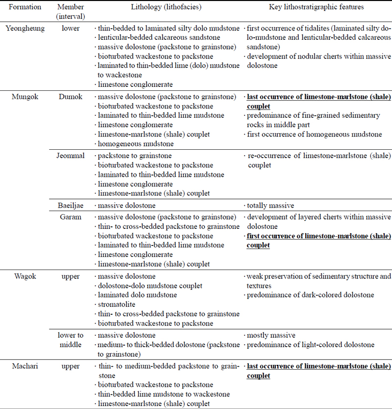
Lithostratigraphic summary of the Yeongwol Group in Namae section. Key features for lithostratigraphic boundaries are underlined and in bold.
3.1. 마차리층 상부
남애 지질단면에 노출된 마차리층 상부(총 14.5 m 두께)는 백운암질 석회암 및 일부 이회암으로 구성되며, 주요 암상에 따라서 백운암질 팩암 및 입자암이 우세한 하부 6.3 m 구간과 백운암질 석회이암 및 와케암과 이회암이 우세한 상부 8.2 m 구간으로 크게 구분할 수 있다(그림 2b, 3a). 이들의 퇴적 구조와 조직은 야외 노두에서 쉽게 인지되지 않으나, 풍화 상태에 따라서 일부 구조 및 조직들이 식별된다. 암석 표본의 연마편 또는 박편을 육안으로 관찰할 경우에 퇴적구조를 더 용이하게 인지할 수 있으며, 현미경 개방니콜 하에서는 대부분 돌로마이트 결정들이 관찰되지만 화이트 카드 관찰을 통해 입자 및 생물골격 조직들이 대체로 식별된다(그림 3b-e, 4).

Lithological features of the uppermost Machari Formation. (a) Field photograph of an entire sequence of the uppermost Machari Formation. (b) Photograph of a thin section of dolomitized limestone (bioturbated wacke to packstone). (c) Enlarged photomicrograph of a rectangle in figure 3b, showing peloids and bivalve shells, taken using the white card method. (d) Field photograph of alternation of dark gray limestone and reddish-brown marlstone (shale) thin beds. Scale bar is in centimeters. (e) Photomicrograph of a boundary of limestone and marlstone (shale) couplets, showing that dolomite crystals occur commonly within a limestone layer.

Stratigraphic interval around the boundary between the Machari and Wagok formations. (a) Field photograph with the lithostratigraphic boundary (dashed line) between the Machari and Wagok formations. (b) Field photograph showing a gradational change of lithofacies in the uppermost Machari Formation, from limestone-marlstone (shale) couplet (L-S) and thin bedded lime mudstone (LM/Wtb), wackestone and packstone (W/P) to massive dolostone (Dm) (packstone to grainstone; P/G). (c) Photograph of a thin section of dolomitic limestone (wackestone to packstone). (d) Enlarged photomicrograph of a rectangle in figure 4c, showing peloids and fossil fragments of probable trilobite, taken using the white card method. (e) Photograph of a thin section showing limestone-marlstone (shale) couplet collected from the uppermost Machari Formation. (f) Enlarged photomicrograph of a rectangle in figure 4e, taken using the white card method. Note that sedimentary structures of both limestone and marlstone layers are partly preserved, but grain components are not identified. Hammer for scale in figures 4a (white circle) and 4b is 28 cm long.
하부 구간의 주 암상은 주로 얇은 및 중간 등급 두께(1~20 cm)의 백운암질 팩암과 입자암으로 구성되며, 와케암이 국부적으로 관찰된다. 층리는 용해심(dissolution seam)의 발달로 인해 쉽게 인지된다(그림 3a). 층 내부는 일반적으로 괴상(massive)이며, 와케암과 팩암에서는 생교란 구조가 관찰된다(그림 3b). 입자는 대부분 펠로이드(peloid)이며, 잔자갈 크기의 석회암편(intraclast) 및 일부 생물골격(bioclast)이 부분적으로 혼재한다(그림 3c). 생물골격은 분절 및 파쇄된 삼엽충, 완족류, 연체동물 골격들의 잔해로서, 골격 내부의 미세구조는 치환된 돌로마이트 결정들로 인해 대부분 관찰되지 않는다(그림 3c). 백운암질 팩암 및 입자암은 등립질(equigranular), 세립질(0.1~0.25 mm), 타형(anhedral) 및 반자형(subhedral)의 돌로마이트 결정들로 치환되어 있으며 제노토픽(xenotopic) 및 하이피디오토픽(hypidiotopic) 조직을 보인다.
상부 구간은 주로 얇은 두께(1~10 cm)의 층상 암회색 백운암질 석회이암 및 와케암으로 구성되며, 부분적으로 얇은 층~엽층(<1 cm)의 적색 및 황록색 이회암(marl)이 협재하여 석회이암-이회암 교호상을 구성한다(그림 3d, 3e). 백운암질 석회이암은 미크라이트(micrite)가 주요 구성물이며, 하이피디오토픽 조직을 보이는 수십 m 크기의 등립질 돌로마이트 결정들로 치환된 생교란 및 침식 구조 흔적들이 인지된다. 이회암 엽층은 주로 균질하며, 부분적으로 엽층리 흔적들이 남아 있다. 이회암 내부에는 수~수십 m 크기의 사방형 돌로마이트 결정들(dolomite rhombs)이 산재해 있다(그림 3e). 이러한 석회이암-이회암 교호상은 층서적 최상부에서 이회암이 점이적으로 사라지며 얇은 층상 석회이암 및 와케암상과 중간 등급의 층상 백운암질 팩암 및 입자암으로 전이된다(그림 4a, 4b). 이 구간의 백운암질 팩암 및 입자암은 하부 구간의 암석들과 퇴적 구조와 조직, 입자의 조성과 함량이 유사하다(그림 4c, 4d).
마차리층은 석회이암 및 이회암이 주요 구성암상으로서 상부에서 층상 백운암질 석회암이 등장하고 점차 그 두께가 두꺼워지는 것으로 변화하는 점이적 경계를 보인다고 알려져 있다(Lee, 1995; Choi, 1998; Lee, 2012a, fig. 2). 남애 지질단면에서 관찰되는 마차리층 최상부는 상향 조립화 및 후층화(coarsening- & thickening-upward) 경향과 함께 와곡층의 괴상 백운암으로 전이되는 점이적 상변화 관계가 확인된다(그림 2b, 4). 이에 마차리층과 와곡층의 경계를 야외에서 쉽게 구분하기 어렵지만, 본 연구에서는 마차리층의 주요 구성암상 중 하나가 석회암-셰일 교호상이고 와곡층은 탄산염암(백운암)으로 구성된다는 기존 암층서 정의(Choi, 1998; Choi and Chough, 2005)를 참고하여 마차리층과 와곡층의 경계를 본 지질단면에서 확인되는 마지막 백운암-이회암 교호상의 최상단 층리면으로 설정하였다(그림 4a, 4e, 4f; 표 1).
3.2. 와곡층
와곡층(총 171 m 두께; 14.5~185.5 m 구간)은 주로 중간~두꺼운 층상(10~100 cm) 및 괴상의 조립질 백운암과 부분적으로 협재하는 세립질 백운암으로 구성된다(그림 2a). 와곡층의 백운암은 야외에서 퇴적구조와 조직이 거의 식별되지 않으며, 현미경 개방니콜에서도 대체로 결정질 돌로마이트 조직으로 관찰된다(그림 5a-c). 그러나 층 기저와 상부의 백운암 박편들을 육안 관찰하거나 화이트 카드로 관찰할 경우 일부 퇴적 구조 및 조직 흔적들이 식별된다(그림 5d-f). 주요 백운암의 색상, 돌로마이트 결정의 조직적 특성, 그리고 퇴적구조와 조직의 야외관찰 가능 여부를 기준으로 밝은 계통의 백운암이 우세한 하~중부(14.5~130 m)와 어두운 계통의 백운암이 우세한 상부(130~185.5 m)로 분할하여 기술한다(그림 2a; 표 1).

Lithological features of the Wagok Formation. (a) Field photograph of light gray massive dolostone in the lower Wagok Formation. Scale bar is in centimeters. (b) Photomicrograph of massive dolostone, showing a xenotopic fabric. (c) Field photograph of thick- to medium-bedded dark gray dolostone in the upper Wagok Formation. Hammer for scale (white circle) is 28 cm long. (d) Photograph of dolomitic packstone to grainstone in the upper Wagok Formation, showing partially well-preserved peloidal and intraclastic grains. (e) Photograph of thin- to cross-bedded packstone to grainstone in the upper Wagok Formation, showing weakly preserved cross-bedding (dotted lines). (f) Photograph of a stromatolite slab sampled from the upper Wagok Formation. (g) Photograph of a thin section of dolostone-dolo mudstone couplet in the upper Wagok Formation, showing development of lamination. (h) Enlarged photomicrograph of a rectangle in figure 5g, showing well-rounded and -sorted peloids, granular intraclasts, and unidentified fossil fragments, taken using the white card method.
와곡층 하~중부(총 115.5 m 두께)는 청회색, 밝은 회색 및 분홍색을 띠는 비교적 밝은 계통의 괴상 백운암들로 구성되며(그림 5a), 암회색 백운암들이 부분적으로 협재 한다(그림 2a; 표 1). 밝은 계통의 백운암에서는 퇴적구조 및 조직이 야외뿐만 아니라 박편에서도 거의 식별되지 않는다. 이러한 백운암은 주로 등립질(equigranular) 및 비등립질(inequigranular), 중립질(0.25~0.5 mm), 타형(anhedral) 및 반자형(subhedral) 결정들이 제노토픽(xenotopic) 조직으로 관찰되며, 부분적으로 조립질(0.5~1 mm) 돌로마이트 결정들이 산재하여 분포한다(그림 5b). 대부분의 암회색 백운암들은 괴상이지만, 마차리층과 접하고 있는 기저부 약 5 m 구간의 층상 백운암과 하부 일부 구간에서는 박편 육안 관찰 및 화이트 카드 현미경 관찰 시 펠로이드 또는 우이드(ooid)와 석회암편이 식별된다. 암회색 계통의 백운암은 등립질, 세립~중립질(0.1~0.5 mm), 타형 및 반자형 결정들이 제노토픽 조직으로 관찰되어 밝은 계통 백운암과 부분적인 조직 차이를 보인다.
와곡층 하~중부는 상부로 갈수록 어두운 계통의 백운암들의 협재 빈도가 증가하며 이들이 우세한 층 상부로 전이된다. 이에 와곡층 하~중부와 상부의 경계는 밝은 계통의 백운암이 거의 사라지고 어두운 계통의 백운암이 십여 미터로 두껍게 퇴적된 구간의 하부 경계면으로 설정하였다(그림 2a).
와곡층 상부(총 55.5 m 두께)는 암회색 및 짙은 암회색을 띠는 어두운 계통의 괴상 및 층상 백운암으로 주로 구성되어 있으며, 층 상부의 중부 구간에 1~2 m 두께의 밝은 회색 괴상 백운암이 국부적으로 협재한다(그림 2a; 표 1). 와곡층 상부의 하부 구간에서는 주로 괴상 및 두꺼운 층상으로 관찰되며, 상부 구간으로 갈수록 점차 층리가 잘 발달하는 경향이 있다(그림 2a, 5c). 어두운 계통의 괴상 백운암은 퇴적구조가 야외에서 쉽게 식별되지 않으나(그림 5c-e), 연마편이나 박편을 육안으로 관찰할 경우 미시 퇴적구조와 조직들이 대체로 관찰된다(그림 5f, 5g). 이 암석들은 개방니콜 하에서 세립질 및 중립질, 타형 및 반자형 결정들로 구성된 제노토픽 조직의 백운암으로 관찰되나, 화이트카드 관찰을 통해 펠로이드, 잔자갈 석회암편 및 일부 삼엽충과 완족류 생물골격들이 확인된다(그림 5h). 중부 구간에 간혹 협재하는 밝은 회색 괴상 백운암은 와곡층 하~중부의 밝은 계통 백운암과 조직적 특성이 유사하여 퇴적구조와 조직의 식별이 어렵다. 특히, 주로 짙은 암회색의 층상 백운암들로 구성된 와곡층의 최상부 20 m 구간에서는 풍화상태에 따라서 스트로마톨라이트, 생교란 구조 및 사층리가 인지된다(그림 5d-h). 이 구간에서는 식별 가능한 생교란된 백운암질 와케암 및 팩암상, 스트로마톨라이트상, 사엽층리 및 얇은 층상 백운암질 팩암/입자암상, 백운암질 팩암/입자암-백운이암 교호상, 엽층리상 백운이암상이 수십 센티미터에서 수 미터 단위로 반복되어 나타난다(표 1).
괴상 및 두꺼운 층상 백운암으로 주로 이루어진 와곡층은 최상부로 갈수록 층상 및 엽층리상 백운암 및 백운이암의 분포 빈도가 점차 높아지며 문곡층 하부(가람층원)의 주요 구성암상(단락 3.3. 참조)으로 점이적으로 변한다(표 1). 와곡층의 최상부는 문곡층 최하부에 처음 등장하는 석회암-이회암(셰일) 교호상의 하부 경계면으로 정의된 바 있으며(표 1; Kim and Choi, 2000, 2002; Choi and Lee, 2001; Kim et al., 2014; Lee et al., 2023), 남애 지질단면에서 또한 쉽게 인지된다(그림 6a).

Stratigraphic interval around the boundary between the Wagok and Mungok formations and lithologic features of the lower Mungok Formation (Garam Member). (a) Field photograph with the lithostratigraphic boundary between the Wagok and Mungok formations, showing a sharp contact between massive dolostone (Dm) and limestone-marlstone (shale) couplet (L-S). (b) Enlarged photograph of a rectangle in figure 6a showing limestone-marlstone (shale) couplets (L-S). (c) Field photograph of bioturbated packstone to grainstone (P/G) and limestone pebble conglomerate (Clp) interbedding packages of limestone-marlstone couplet (L-S) lithofacies. (d) Field photograph of massive dolostone interbedded with layered cherts in the lower Garam Member of the Mungok Formation. Scale bar is in centimeters. (e-f) Field photograph and photomicrograph of laminated lime mudstone (LMl) lithofacies in the upper Garam Member of the Mungok Formation, showing development of parallel- to low-angle cross-lamination, partly obliterated by bioturbation. Hammer (circles) for scale in figures 6a, 6c, and 6e is 28 cm long.
3.3. 문곡층
문곡층(총 189.5 m 두께; 185.5~375 m 구간)은 이회암(셰일)과 석회암-이회암(셰일) 교호상, 석회역암, 백운암질 석회이암 및 와케암, 백운암질 팩암 및 입자암, 괴상 백운암으로 구성되며(그림 6, 7), 탄산염암과 쇄설성 이암의 분포 및 빈도에 따라서 하부로부터 가람, 배일재, 점말 및 두목층원으로 세분된다(그림 2a; 표 1; Kim and Choi, 2000; Kim et al., 2014). 남애 지질단면에서 이 층은 낙석방지벽의 설치로 인해 노출되지 않은 점말층원 중부에서 두목층원 최하부 약 41.5 m 구간을 제외한 전 층서가 관찰된다. 일반적으로 가람과 배일재 층원은 탄산염암의 구성 빈도가 높으며, 점말과 두목층원에서 쇄설성 이암의 퇴적 빈도가 점차 높아진다고 알려져 있다(Kim et al., 2014; Kim and Choi, 2000, 2002). 문곡층은 괴상 백운암 외 모든 암상에서 퇴적구조들이 야외에서 대부분 식별된다. 가람 및 배일재층원에 분포하는 백운암 및 백운암질 석회암은 와곡층 상부의 탄산염암들과 유사하게 돌로마이트 결정들이 크게 성장하여 박편을 개방니콜 상태에서 관찰하는 것보다 육안 및 화이트 카드로 관찰할 때 미세 퇴적 구조, 조직 및 구성 입자를 용이하게 식별할 수 있다. 반면에, 점말 및 두목층원에 분포하는 탄산염암의 박편들은 화이트 카드로 관찰할 경우 덜 성장한 돌로마이트들의 외형이 오히려 강조되어 기존 퇴적구조 및 조직의 관찰을 방해하며, 이에 이 두 층원에서는 박편을 육안 관찰할 경우에 미세 퇴적구조 및 조직을 부분적으로 식별할 수 있다.
가람층원(총 52 m 두께)은 백운암질 석회암, 쇄설성 이암과 처트로 구성된 하부의 혼합암 구간(약 18 m)과 층상 백운암질 석회이암과 괴상 백운암으로 구성된 중~상부의 탄산염암 구간(약 34 m)으로 크게 구분된다(그림 2a, 2c). 가람층원의 최하부는 와곡층 최상부에 처음으로 놓이는 약 2.5 m 두께의 석회암-이회암(셰일) 교호상에 의해 인지된다(그림 6a, 6b).
하부 혼합암 구간은 상부로 갈수록 이회암의 협재 빈도는 줄어들고 탄산염암의 비율은 증가하는 경향이 있다(그림 2c). 이 혼합암 구간은 석회암-이회암 교호상, 사엽층리상 및 층상 팩암 및 입자암상과 괴상 백운암이 순서대로 미터 규모의 윤회 퇴적층(meter-scale cyclic successions)을 이루는 주 구성 암상이며, 생교란된 와케암 및 팩암상과 석회역암상은 드물게 나타난다(그림 6a-d). 윤회층의 최하부를 구성하는 석회암-이회암(셰일) 교호상은 엽층에서 얇은 층상의 석회암-이회암 호층으로서, 석회암 부분은 교호상 내에서 상부로 갈수록 석회이암에서 팩암 및 입자암으로 대체된다. 윤회층 내에서 교호상의 상부에는 사엽층리상 및 층상의 팩암 및 입자암상과 괴상 백운암상이 놓인다. 팩암 및 입자암상은 혼합암 구간의 하부에서 나타나며, 야외에서 퇴적구조와 조직이 대체로 식별되고 펠로이드와 우이드, 극피동물 및 삼엽충과 같은 일부 생물골격 흔적들이 관찰된다. 혼합암 구간 상부에 나타나는 괴상 백운암은 야외에서 퇴적구조와 조직이 거의 확인되지 않으나, 박편 관찰을 통해 펠로이드 팩암 및 입자암 흔적이 부분적으로 확인된다. 이 괴상 백운암에서는 수 cm 두께의 검은색 단괴상 및 층상 처트들이 협재하는데 이 처트들은 문곡층 내에서 가람층원에서만 인지된다(그림 2a, 2b, 6d; 표 1; Kim and Choi, 2000; Choi and Chough, 2005; Kim et al., 2014). 수 cm 두께의 얇은 층상 및 렌즈상 석회역암층은 팩암 및 입자암상과 괴상 백운암 내에 부분적으로 협재한다(그림 6c). 하부 혼합암 구간에서는 이러한 미터 규모의 윤회 퇴적층(meter-scale cyclic deposits)이 크게 네 차례 반복하여 퇴적되어 있다(그림 2c).
가람층원의 중~상부 탄산염암 구간은 회색 및 암회색의 엽층상 및 얇은 층상 석회이암과 괴상 백운암이 수 미터 두께의 윤회 퇴적층을 구성한다(그림 2a). 엽층상 및 얇은 층상 석회이암은 하부에 뚜렷한 경계를 갖고 세립질 돌로마이트 결정으로 구성된 밝은 엽층과 그 상부로 수십 m 크기의 돌로마이트 결정 및 미크라이트로 구성된 어두운 엽층으로 전이되는 점이층리가 반복적으로 발달해 있으며, 종종 저각의 사층리와 생교란 구조들도 관찰된다(그림 6e, 6f). 이 석회이암에서는 종종 얇은 렌즈상 및 층상 팩암 및 입자암층이 협재한다. 괴상 백운암은 가람층원 하부 혼합암 구간 최상부에 분포하는 백운암과 거의 유사한 특징을 보이지만, 처트를 동반하지 않는다. 하부 혼합암과 중~상부 탄산염암 구간의 경계부에 소규모 역단층(충상단층)이 발달하여 수 미터의 층서 반복 구간이 있다.
배일재층원(총 17 m 두께)은 회색 및 암회색의 두꺼운 층상 및 괴상의 백운암으로 구성되어 와곡층과 구분이 어렵지만(그림 7a), 하부로는 가람층원의 층상 백운이암과 처트를 포함하는 괴상 백운암이, 상부로는 점말층원의 석회암-이회암(셰일) 교호상이 놓이는 정합적인 층서 관계를 기반으로 인지될 수 있다(그림 2a, 7b; 표 1). 본 층원의 백운암은 퇴적구조가 거의 관찰되지 않으나, 화이트 카드 관찰을 통해 펠로이드와 일부 생물골격의 흔적들이 부분적으로 식별된다. 이러한 백운암은 등립질(equigranular), 세립질 및 중립질(0.1~0.5 mm), 타형(anhedral) 및 반자형(subhedral) 결정들이 제노토픽(xenotopic) 조직으로 구성되어 가람층원과 와곡층 상부 구간의 백운암들과 유사한 결정 조직을 보인다.

Lithological features of the middle to upper Mungok Formation (Baeiljae, Jeommal, and Dumok members). (a) Field photograph of massive dolostone in the Baeiljae Member. Net for scale (right) is tied at 10 cm intervals. (b) Field photograph of lithostratigraphic boundary (dashed line) between the Baeiljae and Jeommal members, showing a sharp contact between massive dolostone (Dm) and limestone-shale couplet (L-S). (c) Field photograph of lithofacies associations of the lower Dumok Member, including homogeneous mudstone (Mh) or shale (S), limestone-marlstone (shale) couplet (L-S), laminated to thin-bedded lime mudstone (LMl), bioturbated wackestone to packstone (W/Pb), and packstone to grainstone (P/G) facies. (d) Field photograph of a representative lithofacies associations of the middle Dumok Member, showing a few meters-thick homogeneous mudstone (Mh) or shale (S) and limestone-marlstone (shale) couplet (L-S) intercalated with limestone pebble conglomerate (Clp). (e) Photograph of a thin section of limestone-marlstone (shale) couplet lithofacies, showing four packages of couplet, consisting of graded lime mudstone and homogeneous mudstone thin beds to laminae, recognized by erosional surfaces and burrows. (f) Enlarged photomicrograph of a rectangle in figure 7e, showing burrows filled with dolomite crystals. Hammer (circles) for scale in figures 7b, 7c, and 7d is 28 cm long.
남애 지질단면에 대한 기존 문곡층 연구에서는 가람층원을 약 30 m, 배일재층원을 약 35 m 두께로 기재한 바 있다(Kim and Choi, 2000, fig. 4). 그러나, 본 연구에서는 기존 배일재층원으로 구분된 구간에서 여러 차례 협재하는 층상 백운암질 석회이암이 추가로 관찰되었다. 이에 기존 연구자들이 제시한 배일재층원의 암상 정의(즉, 괴상 백운암으로 구성됨)에 맞춰 가람층원과 배일재층원을 각각 52 m와 17 m 두께로 재조정하였다(그림 2a).
점말층원의 하한은 배일재층원의 괴상 백운암 위로 석회암-이회암(셰일) 교호상이 처음 등장하는 지점으로 인지된다(그림 7b; 표 1; Kim and Choi, 2000). 본 층원은 미터 규모의 윤회층을 구성하는 석회암-이회암(셰일) 교호상, 엽층리상 및 얇은 층상 백운암질 석회이암 및 와케암상, 중간 및 두꺼운 층상 백운암질 팩암 및 입자암상과 이들에 협재하는 석회역암상으로 구성되어 있다. 이러한 윤회 퇴적층들은 점말층원 내에서 십여 차례 누적 분포한다고 알려진 바 있다(Kim et al., 2014). 그러나, 남애 지질단면에서는 점말층원이 약 12 m 두께의 하부만 노출되어 이러한 윤회 퇴적층이 크게 세 차례 반복되는 것만 확인되며, 점말층원과 두목층원의 층서적 접촉 관계는 확인되지 않는다(그림 2a).
두목층원(약 67 m 두께)은 점말층원과 유사한 암상 및 윤회 퇴적층으로 구성되어 두 개의 층원을 쉽게 구분하기 어렵지만(Kim et al., 2014), 수십 센티미터 또는 미터 규모의 균질한(homogeneous) 및 엽층리상 이회암(셰일)이 처음으로 등장하는 구간으로 인지가 될 수 있다고 제안된 바 있다(그림 2a, 2d, 7c; 표 1; Kim and Choi, 2000). 두목층원에서는 균질 및 엽층리상 이회암, 석회암-이회암(셰일) 교호상, 엽층리상 및 얇은 층상 백운암질 석회이암 및 와케암, 중간 및 두꺼운 층상 백운암질 팩암 및 입자암이 미터 규모의 윤회 퇴적층을 구성하며, 석회역암상과 얇은 층상 팩암 및 입자암상이 이들에 협재되어 있다(그림 7c). 주요 암상과 이회암의 분포 빈도에 따라서 크게 하부(15.5 m), 중부(35.5 m), 상부(16 m) 구간으로 재차 세분될 수 있다(그림 2d).
하부 구간에서는 상기한 두목층원 퇴적암상 모두가 4~5회의 윤회 퇴적층을 구성한다(그림 2d, 7c). 이 구간에서 관찰되는 모든 윤회 퇴적층의 최상부에는 중간 및 두꺼운 층상 백운암질 팩암 및 입자암상이 위치한다. 중부 구간에서 발달하는 윤회층의 구성상은 하부 구간과 유사하나, 하부 구간과 달리 수 미터 두께의 석회암-이회암 교호상과 엽층리상 및 얇은 층상 석회이암 및 와케암상의 발달과 층상 및 렌즈상 석회역암 또는 팩암 및 입자암상의 빈번한 협재가 특징적이다(그림 7d-f). 중부 구간의 최상부에서는 이회암이 점차 사라지고 층상 및 괴상 팩암 및 입자암이 윤회층의 최상부 퇴적상으로 서서히 나타나는 경향이 있다(그림 2d). 이 구간에서 윤회 퇴적층은 3회 이상 반복적으로 퇴적되어 있다(그림 2d, 7d). 상부 구간은 두꺼운 층상 및 괴상 팩암 및 입자암상, 얇은 층상 백운이암 및 와케암상, 괴상 백운암상 등 주로 탄산염암으로 구성되어 있으며, 이러한 탄산염암들 사이에 수~수십 cm의 균질한 이회암과 석회암-이회암 교호상이 중간과 최상부 구간에 부분적으로 협재한다(그림 2d).
두목층원의 탄산염암은 상부로 갈수록 백운암화 과정이 심화되어 팩암 및 입자암상의 퇴적구조와 조직이 흐릿해지고 괴상의 백운암으로 변해가는 과정이 전반적으로 관찰된다(그림 8). 두목층원에서 관찰되는 엽층리 및 얇은 층상 석회이암과 백운이암은 가람층원 중상부에서 관찰된 것과 유사한 점이층리가 반복적으로 발달해 있다(그림 7e, 7f). 백운암질 팩암 및 입자암과 괴상 백운암은 등립질, 세립질 및 중립질, 타형 및 반자형 결정들이 하이피디오토픽 및 제노토픽 조직으로 구성되어 있다(그림 8d, 8f). 두목층원의 탄산염암에서는 생교란 구조와 해백합, 삼엽충, 연체동물, 완족동물의 골격 화석들이 종종 관찰되나 골격 미세 구조의 보존상태는 대체로 불량하다(그림 7f, 8d-f).

Stratigraphic interval around the boundary between the Mungok and Yeongheung formations. (a) Field photograph of the lithostratigraphic boundary (white dashed line) between the Mungok and Yeongheung formations and the upper stratigraphic limit of the Namae section below a reverse fault (red dashed line). (b) Enlarged field photograph of a rectangle in figure 8a showing the lithostratigraphic boundary between the Mungok and Yeongheung formations. This boundary is delineated by last occurrence of limestone-marlstone (shale) couplet (L-S), located in between laminated dolo-mudstone (DMl) and massive dolostone (Dm). (c) Enlarged field photograph of a rectangle in figure 8b, showing occurrence of limestone pebble conglomerate (Clp) within the L-S lithofacies interval. (d) Photomicrograph of massive dolostone (packstone to grainstone; P/G) in the uppermost Mungok Formation, showing peloids and a shell fragment. (e) Photograph of a thin section of limestone pebble conglomerate in the lowermost Yeongheung Formation. (f) Enlarged photomicrograph of a rectangle in figure 8e, showing intraclasts and grainy matrix consisting of peloids and fossil fragments. Hammer for scale in figures 8b and 8c is 28 cm long.
남애 지질단면에 대한 기존 문곡층 연구에서는 두목층원이 약 45 m(예, Kim and Choi, 2000, fig. 4; Kim et al., 2009, fig. 2) 또는 약 58 m 두께(예, Cho and Kim, 2007, fig. 3G)로 다르게 기재된 바 있다. 전자의 경우는 하부와 중부 구간만을 포함시킨 경우이며, 중부 구간 최상부의 마지막 석회암-이회암 교호상의 최상단까지를 문곡층의 상한으로 기재했던 것으로 판단된다(Kim and Choi, 2000). 후자의 경우는 하부~상부 일부 구간을 포함시킨 경우로서 상부 구간 중간에 협재하는 석회암-이회암 교호층의 최상단을 문곡층의 상한으로 기재한 것으로 보인다(그림 2d; Cho and Kim, 2007). 석회암-이회암 교호상은 문곡층을 정의하는 주요 암상 중 하나이며, 하부의 와곡층과 상부의 영흥층은 주로 탄산염암으로만 구성된다는 기존 암층서 정의에 기반하여(Choi, 1998; Choi and Chough, 2005), 본 연구에서는 문곡층의 상한 및 영흥층의 하한을 두목층원 최상부에 약 40 cm 두께로 분포하는 석회암-이회암 교호상의 최상단으로 설정하였다(그림 8a-c; 표 1). 이 경계는 기존 연구들에서 제시되었던 암층서 경계보다 층서적 상부로 약 9~13 m 더 위쪽에 위치한다.
3.4. 영흥층 하부
남애 지질단면에 노출된 영흥층 하부(총 38 m 두께; 375~413 m 구간)는 주로 엽층리 및 얇은 층상 백운이암과 두꺼운 층상 및 괴상 백운암을 포함한 탄산염암으로 구성되어 있으며, 부분적으로 처트와 석회질 사암이 협재한다(그림 2d, 9; 표 1). 이러한 백운암 및 백운이암의 퇴적 구조와 조직은 야외 노두에서 쉽게 식별되지 않으나, 풍화 상태에 따라서 일부 구조들이 확인되고 던햄 분류가 부분적으로 가능하며, 박편을 육안으로 관찰하는 경우에 퇴적구조 및 조직을 더 쉽게 인지할 수 있다(그림 8, 9). 영흥층은 얇은 층상 백운이암과 괴상 백운암이 미터 규모의 윤회 퇴적층을 형성하며 반복적으로 퇴적된 하부 구간(약 24 m 두께)과 얇은 층상 및 엽층리상 백운이암으로 대부분 구성되어 있는 상부 구간(약 14 m 두께)으로 세분된다(그림 2d).
하부 구간은 문곡층 최상부 석회암-이회암 교호층 위로 석회역암을 포함한 얇은 층상 백운이암과 괴상 백운암이 점이적인 순서로 놓이는 것으로 시작되며(그림 8c), 상부로 백운이암과 백운암으로 구성된 탄산염 윤회 퇴적층이 세 차례 더 반복된다(그림 2d). 이러한 백운이암과 백운암은 문곡층 두목층원 중상부 구간의 백운암질 석회암 및 백운암과 유사한 돌로마이트 결정조직으로 관찰되며, 엽층리, 생교란 구조, 탄산염 입자의 흔적은 야외에서 쉽게 인지되지 않으나 박편 관찰을 통해서 부분적으로 식별된다(그림 9a, 9b). 특별히, 하부 구간의 괴상 백운암에서는 수 cm 크기의 흑색 단괴상 처트들이 중부와 상부 지점에서 두 차례 관찰되는데(그림 9c), 이러한 처트들은 문곡층 가람층원에서 특징적으로 관찰되는 층상 및 단괴상 처트 군집보다 평균 크기가 작고 밀도 면으로 낮게 나타난다(예, 그림 6d).
상부 구간은 대부분 얇은 층상 및 엽층리상 실트질 백운이암으로 구성되며, 최상부에 약 1 m 두께의 괴상 백운암이 놓인 이후 역단층에 의해 영흥층 하부 구간이 다시 반복되며 남애 지질단면의 층서 기록이 단절된다(그림 2d, 8a, 9d-f). 이 구간에서 관찰되는 얇은 층상 및 엽층리상 실트질 백운이암은 약 0.3~2.5 m 두께로 반복되는 상향 박층화 시퀀스(thinning-upward sequences)로 구성되어 있다. 이러한 상향 박층화 시퀀스는 하부에는 얇은 층상으로 시작되어 상부로 점차 평행, 파동형, 및 렌즈상 엽층리로 점이적인 층리 변화가 일어나며(그림 9d), 엽층리 구간은 하부에 침식면을 갖는 밝은색의 실트질 백운이암과 상부로 어두운 색의 백운이암으로 전이되는 점이층리들로 구성된다(그림 9e, 9f). 이 구간에서는 측방 연속성이 불량하고 두께가 다양한 각력암들이 종종 협재하며, 일부 구간에서는 원마도가 좋은 석영 모래 입자를 포함하는 석회질(백운암질) 사암 엽층 및 박층이 협재한다(그림 9d, 9f). 이러한 상향 박층화 실트질 백운이암에서는 영흥층 최하부 구간 및 문곡층의 엽층리 및 얇은 층상 석회(백운)이암상에서 관찰되는 생교란 구조나 화석 파편들(예, 그림 6f, 7e, 9b)은 거의 관찰되지 않는다(그림 9e, 9f).

Lithological features of the lower Yeongheung Formation. (a-b) Field photograph and photomicrograph of laminated dolo mudstone (DMl). This facies unit consists of sets of homogeneous lime mudstone and marlstone thin beds to laminae with burrows. (c) Field photograph of massive dolostone (Dm) including chert nodules (arrows). (d) Field photograph and photomicrograph in an inset of calcareous sandstone (CS). This facies that contain well-rounded quartz sand grains is underlain by limestone pebble conglomerate (Clp) and overlain by laminated silty dolo mudstone (DMls). (e-f) Field photograph and photomicrograph of laminated silty dolo mudstone (DMls), showing low-angle cross lamination and intercalation of lenticular calcareous siltstone laminae. Note that there are no fossils in this lithofacies, such as bioturbation and skeletal fragments. Scale bar in figures 9a, 9c, 9d, and 9e is in centimeters.
남애 지질단면에 노출된 영흥층에서 상부 구간의 대부분을 구성하는 상향 박층화 층상 및 엽층리상 실트질 백운이암 구간은 기존 영흥층 연구에서 다수 보고된 조간대 퇴적상조합의 특징을 보여준다(Choi and Woo, 1993; Yoo and Lee, 1997; Park et al., 2017; Kwon and Kwon, 2020). 처트가 포함된 백운암과 석회질 사암은 본 연구에서 최초 보고하는 암상으로서, 영흥층 하부에 대한 암상 구성이 기존의 보고보다 다양했음을 시사한다. 문곡층 최상부에서 마지막으로 관찰되는 백운이암-이회암 교호상 이후로 영흥층은 주로 괴상 백운이암과 백운암으로 구성된 탄산염암 구간(약 24 m)이 형성된 뒤, 다시 두꺼운 조간대성 실트질 엽층리암(peritidal laminite)이 발달하는 특징이 있는데, 이러한 암상 변화가 일어나는 구간은 기존 영흥층 연구 지역에서는 관찰된 적이 없다(예, Yoo and Lee, 1997, fig. 2; Kwon and Kwon, 2020, fig. 6). 따라서, 본 지질단면에서 노출된 영흥층 최하부는 영월층군에서 조하대 탄산염 대지의 발달 후 처음으로 기록된 조간대 환경의 퇴적층을 보여준다고 할 수 있다.
4. 토론: 남애 지질단면의 지질학적 가치와 향후 연구 전망
남애 지질단면은 마차리층 상부부터 영흥층 하부까지 구조적 단절 없이 연속적으로 노출되어 있으며, 영월층군 내 5개 지층 사이의 4개 경계면 중 삼방산층과 마차리층의 경계를 제외한 3개의 층서 단위 경계가 모두 관찰되는 유일한 지질단면이다(그림 1d, 2). 이 지질단면은 현재까지 정확하게 보고된 적이 없었던 와곡층의 전층서, 문곡층의 상한 및 영흥층 하부층에 대한 층서 기록을 보존하고 있다(표 1). 이에 본 단락에서는 남애 지질단면에서 관찰된 각 신규 층서 구간의 기존 연구결과를 검토하고 지질학적 중요성과 학술적 가치에 대해 논하고자 한다.
4.1. 와곡층의 암층서 구축과 지질학적 가치
와곡층은 영월층군 내에서 가장 극심한 백운암화 작용으로 인해 퇴적구조와 화석의 보존 상태가 불량하여 지질학적 연구가 거의 수행되지 않은 암층서 단위이다(Choi, 1998; Choi and Chough, 2005). 와곡층은 뚜렷한 암질의 특징이 없는 괴상의 백운암으로서, 천해 조하대 여울 또는 조간대 퇴적층으로 알려져있으나, 이는 일부 보존된 삼엽충과 완족동물 등 생물골격과 우이드의 잔존물의 존재를 통한 추정으로서 퇴적학적 근거는 극히 미미하다(Choi, 1998; Kwon, 2012; Chough, 2013). 와곡층의 상한은 문곡층의 층서 고생물학 및 퇴적학 연구를 통해 다양한 지질단면에서 보고가 이루어진 것에 비해(예, Kim and Choi, 2000, 2002; Choi and Lee, 2001; Kim et al., 2014), 하한은 마차리층의 최상부 코노돈트 생층서대가 정립된 곡금 지질단면에서 유일하게 제시되었다(그림 1c; Lee, 2012a). 곡금 지질단면은 층상 석회암이 괴상의 백운암으로 점이적으로 전이되는 마차리층과 와곡층의 경계부가 관찰된다고 알려져 있지만(예, Lee, 1995; Choi, 1998), 와곡층의 하부 일부만 관찰될 뿐만 아니라 변위가 큰 평창단층의 인근에서 구조적 변형을 받아서 층서학적 기록이 비교적 온전하지 못하다. 현재까지 와곡층에 대한 암층서 기록이 단일 지질단면에서 이루어진 것은 전무하며, 층후 역시 250 m 미만의 추정치 외에 알려져 있지 않다(Choi, 1998). 와곡층에서 설정된 생층서대 역시 전무하며, 그 퇴적 시기는 주로 마차리층의 최상부 코노돈트 생층서대(Eoconodontus notchpeakensis Zone)와 문곡층의 최하부 삼엽충 생층서대(Yosimuraspis vulgaris Zone)를 참고하여 최후기 캄브리아기 제10절 중후기부터 캄브리아기-오르도비스기 경계로 추정된 바 있다(그림 7; Kim and Choi, 2000; Choi et al., 2003, 2016; Lee, 2012a; Choi and Park, 2017). 한편, 영월층군에서 최후기 캄브리아기에 해당하는 Fatocephalus hunjiangensis 삼엽충 생층서대는 평창단층의 서부 어상천면(삼태산 지질단면)에서 유일하게 보고되었는데, 암층서적으로는 와곡층이 아닌 마차리층 최상부 층준에서 발굴된 것으로 제시되었다(Sohn and Choi, 2002). 어상천면(삼태산 지질단면)에 노출된 영월층군의 암층서 기록은 영월층군 층서 구축의 근간이 되는 평창단층의 동부지역 층서와는 상이한데(그림 1c; Sohn and Choi, 2002, fig. 2), 이는 해당 연구에서 저자들이 발견한 대부분의 화석이 심한 구조적 변형을 받았다는 점에 근거하여 노출된 지층들 또한 구조적 변형에 영향을 받아서 층서가 온전하게 보존되어 있지 않을 가능성이 높다는 것을 시사한다.
남애 지질단면에 노출된 와곡층은 명확한 상하부 경계를 포함하여 전체 층서가 모두 관찰되며, 영월지역 내 충상단층에 의한 지층 변형에도 불구하고 변위가 큰 주요 단층(예, 마차리단층, 평창단층)으로부터 상대적으로 원거리에 위치하여 암석들의 보존 상태가 양호하다(그림 1, 2). 남애 지질단면에서는 와곡층의 최하부 최소 5 m와 최상부 최소 20 m 구간을 포함하여 주로 어두운 계통의 백운암에서 1차 퇴적구조 및 조직을 포함하여 생물골격 입자들이 대체로 보존되어 있으며, 상이한 퇴적작용의 산물로 판단되는 다섯 가지 이상의 암상이 인지된다(표 1). 이는 퇴적상 분석을 통한 퇴적환경 해석이 최소한 부분적으로 가능함을 의미하며 향후 와곡층의 퇴적과정에 대한 이해가 크게 제고될 가능성이 높음을 시사한다. 또한, 남애 지질단면에 노출된 와곡층은 약 171 m 두께로서, 250 m 미만이라는 기존에 알려진 층후 추정치 예상에 부합하는 결과를 제시할 뿐만 아니라 하부와 상부를 구성하는 주요 암상 사이에 차이점이 식별되어 향후 면밀한 연구를 통해 층원 단위의 세분이 가능할 것으로 사료된다(그림 2a; 단락 3.2 참조). 이는 다른 지역에 불완전하게 노출된 와곡층의 암층서적 위치를 판단하고 지층 대비의 기준으로 활용될 수 있다. 게다가 일부 층준에서는 화석골격들의 보존상태가 확인되었기 때문에 탄산염암의 용해처리로 얻을 수 있는 화석 표본 수집이 일부 가능하여(예, 코노돈트) 생층서 연대에 대한 이해를 제고할 수 있을 것으로 예상된다. 따라서, 남애 지질단면의 와곡층은 다양한 지질학적 연구의 기회를 제공하며, 영월지역 최후기 캄브리아기의 지질사를 더 자세히 이해할 수 있는 잠재적 연결 고리가 될 가능성이 높을 것으로 사료된다.
4.2. 문곡층과 영흥층의 암층서적 경계부 정의에 대한 개선과 그 지질학적 중요성
영월층군에서 문곡층은 뚜렷한 암상 변화와 다양한 화석 산출에 근거하여 층서뿐만 아니라 퇴적과정에 대한 이해가 가장 높은 층서 단위이지만, 영흥층은 탄산염암으로 구성된 단조로운 암상과 심각한 구조적 변형으로 인해 삼방산층과 더불어 층서적 이해가 가장 불분명한 지층으로 여겨진다(Choi, 1998; Chough and Choi, 2005; Lee et al., 2023). 특히, 영흥층의 기저 및 하부에 대한 층서 기록은 현재까지 명확하게 기록된 적이 없었는데, 그 원인으로 문곡층 상부 또는 영흥층 하부 경계 구간이 종종 충상단층으로 단절되어 두 지층 단위 사이의 연속성이 잘 확인되지 않는다는 것이 지목된 바 있다(예, Choi and Woo, 1993; Kim and Choi, 2000; Cho and Kim, 2007). 다만, 일부 문곡층과 영흥층의 고생물학 및 층서퇴적학적 연구에서 문곡층의 상한과 영흥층의 하한에 대한 정보가 일부 기재되어 있으나, 해당 연구들에서도 서로 다른 기준으로 경계를 설정하고 있기 때문에 영흥층 하한의 층서적 위치와 영흥층의 하부 구간의 퇴적 환경 및 그 시기적 변화에 대한 정보가 불분명하다(예, Yoo and Lee, 1997; Lee and Lee, 1999; Kim and Choi, 2000; Cho and Kim, 2007; Kim et al., 2014; Kwon and Kwon, 2020). 문곡층과 영흥층의 경계가 확인된 것으로 보고된 지질단면은 두목, 남교, 욱가골, 가래재, 도장골, 연정3, 및 남애 지질단면 등이 있으며(Kim and Choi, 2000, 2002; Cho and Kim, 2007; Kim et al., 2014), 이 중 두목 지질단면은 문곡층 두목층원의 표식지로 제시된 바 있다(Kim and Choi, 2000). 그러나, 두목 지질단면에 노출된 두목층원은 현재 그 하부의 점말층원과 상부의 영흥층과의 경계가 각각 약 20 m와 10 m씩 식생과 토양에 덮여 있어서 상하 경계부에 대한 지층 연속성이 확인되지 않으며, 도장골과 연정3 지질단면은 오늘날 주택이 지어졌거나 콘크리트 낙석 방지벽이 설치되어 확인이 불가능하고, 남교, 욱가골, 가래재 지질단면의 경계 구간은 단층 및 습곡이 발달하거나 지층들의 주향 및 경사가 크게 달라지는 것이 관찰되어 지층 연속성이 보장되지 않는 문제가 있다(개별 관찰; 그림 1c).
조간대 환경에서 퇴적된 엽층리상 실트질 백운이암은 영흥층의 대표적인 암상으로서 종종 영흥층의 최하부를 규정하는 암상으로 소개된 바 있다(예, Kim and Choi, 2000; Cho and Kim, 2007). 그러나, 문곡층과 영흥층의 경계부에서는 조하대(그림 8b, 8c, 9a, 9b)와 조간대 환경(그림 9d-f)에서 쌓인 두 종류의 엽층리상 백운이암이 관찰되는데, 박편을 통해서 면밀히 관찰하지 않으면 야외에서 두 암상을 구분하는 것은 매우 어렵다. 이에 조간대성 엽층리암을 기준으로 영흥층의 하한을 설정하는 것은 관찰자마다 문곡층 전 층준에 걸쳐 분포하는 조하대 엽층리암을 조간대성 엽층리암으로 오인할 소지가 높기 때문에 층서 경계를 정의하는 암상으로는 부족한 면이 있다. 남애 지질단면에서 문곡층과 영흥층의 경계부는 혼합암상에서 탄산염암상으로 전이되는 점이적 암상 변화를 보이는 동시에 하부의 문곡층에서 상부의 영흥층으로 갈수록 탄산염암의 백운암화 강도가 점차 높아진다는 점에서 마차리층과 와곡층의 경계부와 매우 유사한 특징을 보인다(그림 2). 본 연구에서 설정한 문곡층과 영흥층의 암층서적 경계는 문곡층의 석회암-이회암 호층이 마지막으로 관찰되는 구간으로서, 이 경계는 기존에 생각했던 암층서 경계들 보다 층서적으로 더 위쪽에 위치한다(그림 2d; Lee and Lee, 1999; Kim and Choi, 2000; Cho and Kim, 2007; Kwon and Kwon, 2020). 문곡층 두목층원의 중부구간은 하부와 상부 구간에 비해 대부분 세립질 퇴적층으로 구성되고 석회역암층들이 더 빈번하게 협재하는 특징이 있는데, 이러한 세립퇴적층의 누적 분포 구간은 다른 지역에서도 관찰될 여지가 있는 수직적 암상변화 경향이며(예, Kim and Choi, 2000, fig. 4; Kim et al., 2014, fig. 6), 광역 대비의 중요한 기준층으로 활용 가능성이 있다. 또한, 영흥층의 하부는 처트가 포함된 백운암 두 매와 탄산염질 사암이 협재된 조간대 엽층리암이 각각 하부와 상부에서 순서대로 인지되는데, 이는 추후 영층층의 하한과 하부를 식별하고 대비하는데 필요한 잠재적 열쇠층으로 활용될 수 있다. 이처럼 문곡층과 영흥층의 경계부는 점이적인 암상변화를 보이지만, 광역적으로 대비가 될 수 있는 다양한 열쇠층들이 존재하며, 이러한 요소들을 종합적으로 고려하여 본 연구에서 문곡층과 영흥층의 경계부에 대한 정의를 개선하였다.
남애 지질단면은 두목층원의 최하부가 일부 노출되지 않았으나, 두목층원의 대부분을 관찰할 수 있는 동시에 문곡층과 영흥층의 경계를 정의할 수 있다는 조건에서 영월층군의 하부 오르도비스계 층서 구축을 위한 중요한 연결고리를 제공할 수 있다. 특히, 기존 문곡층의 고생물 생층서 연구에서 제시된 최상부 생층서대의 암층서적 위치보다 상부로 약 50~60 m의 지층이 더 노출되어 있기 때문에 추가적인 고생물 생층서 연구를 수행할 수 있는 기반이 마련된다. 예를 들면, 영월층군 내 트레마독절과 플로절의 연대 경계가 문곡층 내에 위치하는지(예, Choi, 1998; Lee and Lee, 1999), 문곡층과 영흥층의 암층서 경계부에 위치하는지(예, Kim and Choi, 2000; Choi and Chough, 2005; Choi et al., 2016; Choi and Park, 2017; Choi, 2019a), 아니면 영흥층 내에 위치하는지(예, Cho and Kim, 2007; Choi and Park, 2017; Lee, 2020)에 대한 다양한 가설들을 검증할 수 있는 최적의 장소가 될 수 있다. 영흥층은 천해 조하대-조간대 탄산염 대지에서 쌓인 두꺼운 탄산염암으로 해석되어 왔지만(Choi and Woo, 1993; Yoo and Lee, 1997; Park et al., 2017; Kwon and Kwon, 2020), 이렇게 영월층군에서 가장 천해에 퇴적된 암상이 어떻게 처음 등장하는지에 대해서는 그 과정이 불분명하다. 예를 들면, 최근에 수행된 영흥층의 순차층서 연구에서는 영흥층의 최하부 구간을 남애 지질단면에서 약 20 m 관찰하여 두목 지질단면에 노출된 영흥층 약 30 m 구간에 연결하여 고 해수면 변동 모델을 제시 하였는데(Kwon and Kwon, 2020, figs. 6 and 7), 해당 연구에서 제시된 남애 지질단면의 영흥층은 실제로 문곡층 두목층원의 중상부 구간으로서 추가로 노출되어 있는 약 45 m의 두목층원 최상부 및 영흥층의 하부 구간이 빠져 있다(그림 2d). 남애 지질단면의 문곡층 두목층원부터 영흥층까지의 층서 구간은 조하대 환경에서 첫 조간대 환경으로 점이적인 변화가 기록되어 있으며, 향후 이 구간에 대한 현미 퇴적상 분석, 고빈도 순차층서 분석 및 동위원소 및 지화학 연구 등과 같은 추가 연구가 수행된다면 영월층군의 오르도비스기 고환경 시스템에 대한 이해를 개선할 수 있는 기반을 제공할 것으로 사료된다.
5. 결 론
남애 지질단면은 영월층군에서 가장 연속적인 층서를 관찰할 수 있는 지질단면으로서, 여기에는 마차리층 최상부(약 14.5 m), 와곡층 전층서(총 171 m), 문곡층 전층서(총 189.5 m), 영흥층 하부(약 38 m)를 포함하여 총 413 m 층후의 영월층군 상부 캄브리아계~하부 오르도비스계 퇴적층이 노출되어있다. 마차리층과 와곡층의 경계는 쇄설암-탄산염암의 혼합암상에서 탄산염암으로 전이되는 점이적 경계가 관찰되며, 두 지층에 대한 기존 암층서 정의에 따라서 마차리층 최상부에서 이회암이 마지막으로 관찰되는 지점으로 경계를 설정하였다. 백운암으로 대표되는 와곡층은 상하 경계가 모두 확인될 뿐만 아니라 최하부와 상부 구간에서 퇴적구조와 조직, 주요 탄산염 퇴적입자 및 화석 파편들의 보존 상태가 확인되어 추후 퇴적학 및 일부 고생물학 연구의 전망을 밝게하며, 문곡층은 가람층원, 배일재층원, 점말층원 일부 및 두목층원 대부분을 포함하여 점말층원과 두목층원의 경계를 제외한 모든 층원의 상하 경계가 확인되어 기존 연구 지역의 대체 연구지 및 대비 노두로서의 잠재성을 갖는다. 특히, 남애 지질단면에서는 현재까지 모호했던 문곡층(두목층원)과 영흥층의 암층서 경계부가 노출되어 있는데, 두 층간 경계는 기존에 이 단면에서 설정되었던 경계보다 층서적으로 더 위쪽에 위치한다. 영흥층의 최하부는 처트를 포함한 백운암 및 석회질 사암을 포함한 엽층리상 실트질 백운이암으로 구성되어 현재까지 보고된 적 없었던 영흥층의 첫 조간대 주변 탄산염 대지 환경의 퇴적 기록을 담고 있다. 남애 지질단면은 영월지역의 충상단층 시스템에서 영월층군의 최하부 삼방산층을 제외하고 네 개의 암층서 단위의 층간 경계가 모두 확인되는 이례적인 지질단면으로서 서부 태백산 분지 층서 구축의 기반을 제공하고 전기 고생대 지사에 대한 이해를 개선할 수 있는 중요한 연결고리를 제공한다. 따라서, 본 지질단면은 현재 노출된 모든 층서 구간이 미래 연구자들을 위한 연구 및 교육의 현장으로 활용되기에 충분한 학술적 가치를 지니고 있다고 사료된다.
Acknowledgments
본 연구는 2023년도 정부(과학기술정보통신부, 교육부)의 재원으로 한국연구재단 창의도전연구기반지원사업(No. RS-2023-00246923), 신진연구자지원사업(No. 2020R1C1 C1007690), 대학중점연구소지원사업(No. 2019R1A6A1A 03033167)의 지원을 받아 수행되었습니다. 원고의 질 향상을 위해 건설적인 조언을 주신 편집자와 심사위원분들께 감사드립니다. 야외 및 실내 조사 과정에서 도움을 준 고려대학교 지구환경과학과 조세현군, 강원대학교 지질학과 이새롬, 이은수, 강수정양께 감사드립니다.
References
-
Bang, S. and Lee, Y.I., 2020, Darriwilian carbon isotope stratigraphy in the Taebaeksan Basin, Korea and its implications for Middle Ordovician paleoceanography. Palaeogeography, Palaeoclimatology, Palaeoecology, 541, 109534.
[https://doi.org/10.1016/j.palaeo.2019.109534]

-
Cho, H.S. and Kim, J.Y., 2007, Graptolite biostratigraphy and its correlation of the Mungok and Yeonghung formations at Yeongwol area, Korea. Geosciences Journal, 11, 23-38.
[https://doi.org/10.1007/BF02910378]
-
Choi, D.K., 1998, The Yongwol Group (Cambrian-Ordovician) redefined: a proposal for the stratigraphic nomenclature of the Choson Supergroup. Geosciences Journal, 2, 220-234.
[https://doi.org/10.1007/BF02910166]
-
Choi, D.K., 2019a, Evolution of the Taebaeksan Basin, Korea: I, early Paleozoic sedimentation in an epeiric sea and break-up of the Sino-Korean Craton from Gondwana. Island Arc, 28, e12275.
[https://doi.org/10.1111/iar.12275]
-
Choi, D.K., 2019b, Evolution of the Taebaeksan Basin, Korea: II, late Paleozoic sedimentation in a retroarc foreland basin and assembly of the proto-Korean Peninsula. Island Arc, 28, e12277.
[https://doi.org/10.1111/iar.12277]
-
Choi, D.K. and Chough, S.K., 2005, The Cambrian-Ordovician stratigraphy of the Taebaeksan Basin, Korea: a review. Geosciences Journal, 9, 187-214.
[https://doi.org/10.1007/BF02910579]
-
Choi, D.K., Kim, D.H., Sohn, J.W. and Lee, S.-B., 2003, Trilobite faunal successions across the Cambrian-Ordovician boundary intervals in Korea and their correlation with China and Australia. Journal of Asian Earth Sciences, 21, 781-793.
[https://doi.org/10.1016/S1367-9120(02)00106-2]
-
Choi, D.K., Kim, E.-Y. and Lee, J.G., 2008, Upper Cambrian polymerid trilobites from the Machari Formation, Yongwol, Korea. Geobios, 41, 183-204.
[https://doi.org/10.1016/j.geobios.2007.05.005]
- Choi, D.K., Lee, J.G. and Choi, S.Y., 1999, Middle Cambrian trilobites from the Sambangsan Formation in Yongwol area, Korea. Journal of the Paleontological Society of Korea, 2, 134-144.
-
Choi, D.K., Lee, J.G., Lee, S.-B., Park, T.-Y.S. and Hong, P.S., 2016, Trilobite Biostratigraphy of the lower Paleozoic (Cambrian-Ordovician) Joseon Supergroup, Taebaeksan Basin, Korea. Acta Geological Sinica, 90, 1976-1999.
[https://doi.org/10.1111/1755-6724.13016]
-
Choi, D.K. and Park, T.-Y.S., 2017, Recent advances of trilobite research in Korea: Taxonomy, biostratigraphy, paleogeography, and ontogeny and phylogeny. Geosciences Journal, 21, 891-911.
[https://doi.org/10.1007/s12303-017-0041-5]
- Choi, S.J. and Woo, K.S., 1993, Depositional environment of the Ordovician Yeongheung Formation near Machari Area, Yeongweol, Kangweondo, Korea. Journal of the Geological Society of Korea, 29, 375-386.
- Choi, Y.S. and Lee, Y.I., 2001, Facies and sequence analysis on the Lower Ordovician Mungok Formation. The Korean Journal of Petroleum Geology, 9, 1-15 (in Korean with English abstract).
- Chough, S.K., 2013, Geology and sedimentology of the Korean Peninsula. Elsevier, Amsterdam, 363 p.
-
Chough, S.K., Kwon, S.-T., Ree, J.-H. and Choi, D.K., 2000, Tectonic and sedimentary evolution of the Korean peninsula: a review and new view. Earth-Science Reviews, 52, 175-235.
[https://doi.org/10.1016/S0012-8252(00)00029-5]
- Chung, G.S. and Lee, E.-K., 2002, Depositional environment of the Cambrian Machari Formation in the Yeongweol area, Gangweon Province, Korea. Journal of the Korean Earth Science Society, 23, 72-86.
-
Chung, G.S., Lee, J.G. and Lee, K.S., 2011, Stable carbon isotope stratigraphy of the Cambrian Machari Formation in the Yeongweol area, Gangweon provice, Korea. Journal of the Korean Earth Science Society, 32, 437-452.
[https://doi.org/10.5467/JKESS.2011.32.5.437]
-
Folk, R.L., 1987, Detection of organic matter in thin-sections of carbonate rocks using a white card. Sedimentary Geology, 54, 193-200.
[https://doi.org/10.1016/0037-0738(87)90022-4]
-
Friedman, G.M., 1965, Terminology of crystallization textures and fabrics in sedimentary rocks. Journal of Sedimentary Research, 35, 643-655.
[https://doi.org/10.1306/74D7131B-2B21-11D7-8648000102C1865D]
-
Hong, J., Choh, S.-J., Park, J. and Lee, D.-J., 2017, Construction of the earliest stromatoporoid framework: Labechiid reefs from the Middle Ordovician of Korea. Palaeogeography, Palaeoclimatology, Palaeoecology, 470, 54-62.
[https://doi.org/10.1016/j.palaeo.2017.01.017]
-
Hong, P.S. and Choi, D.K., 2015, Cambrian series 3 agnostoid trilobites Ptychagnostus sinicus and Ptychagnostus atavus from the Machari Formation, Yeongwol Group, Taebaeksan Basin, Korea. Journal of Paleontology, 89, 377-384.
[https://doi.org/10.1017/jpa.2015.30]
-
Hong, P.S., Lee, J.G. and Choi, D.K., 2003, Trilobites from the Lejopyge armata Zone (Upper Middle Cambrian) of the Machari Formation, Yongwol Group, Korea. Journal of Paleontology, 77, 895-907.
[https://doi.org/10.1666/0022-3360(2003)077<0895:TFTLAZ>2.0.CO;2]
-
Hong, S.K., Lee, Y.I. and Jeong, S.Y., 2011, Carbon isotope composition of Upper Cambrian to Lower Ordovician carbonate in Korea, and its bearing on the Cambrian–Ordovician boundary and Lower Ordovician paleoceanography. Journal of Asian Earth Sciences, 40, 252-260.
[https://doi.org/10.1016/j.jseaes.2010.07.007]
-
Jeon, J., Park, J., Choh, S.-J. and Lee, D.-J., 2017, Early labechiid stromatoporoids of the Yeongheung Formation (Middle Ordovician), Yeongwol Group, mideastern Korean Peninsula: Part II. Systematic paleontology and paleogeographic implications. Geosciences Journal, 21, 331-340.
[https://doi.org/10.1007/s12303-016-0055-4]
-
Kim, D.H. and Choi, D.K., 2000, Lithostratigraphy and biostratigraphy of the Mungok Formation (Lower Ordovician), Yongwol, Korea. Geosciences Journal, 4, 301-311.
[https://doi.org/10.1007/BF02914039]
-
Kim, D.H. and Choi, D.K., 2002, Facies of a Lower Ordovician carbonate shelf (Mungok Formation: Taebaeksan Basin, Korea). Facies, 47, 43-56.
[https://doi.org/10.1007/BF02667705]
- Kim, I.S., Cheong, C.H. and Lee, H.Y., 1985, Trilobites from the Sambangsan Formation in the eastern side of the Pyeongchang area, Kangweon-do, South Korea. Journal of the Geological Society of Korea, 21, 45-49 (in Korean with English abstract).
-
Kim, J.Y., Choi, S.K., Jin, Y.P. and Kim, K.S., 2009, Late Tremadocian graptolites from the Mungok Formation of the Namaeri and Baeiljae sections at Yeongwol, Korea. Journal of the Korean Earth Science Society, 30, 646-659.
[https://doi.org/10.5467/JKESS.2009.30.5.646]
-
Kim, Y.-H., Rhee, C.W., Woo, J. and Park, T.-Y.S., 2014, Depositional systems of the Lower Ordovician Mungok Formation in Yeongwol, Korea: implications for the carbonate ramp facies development. Geosciences Journal, 18, 397-417.
[https://doi.org/10.1007/s12303-014-0033-7]
-
Kwon, Y.J. and Kwon, Y.K., 2020, Sequence stratigraphy in the Middle Ordovician carbonate successions (Yeongheung Formation), mid-east Korea: Paleogeographic implications for a land-detached ramp-type platform. Journal of Asian Earth Sciences, 193, 104263.
[https://doi.org/10.1016/j.jseaes.2020.104263]
-
Kwon, Y.K., 2012, Sequence stratigraphy of the Yeongweol Group (Cambrian-Ordovician), Taebaeksan Basin, Korea: Paleogeographic implications. Economic and Environmental Geology, 45, 317-333.
[https://doi.org/10.9719/EEG.2012.45.3.317]
- Kwon, Y.K., Kwon, Y.J., Yeo, J.M. and Lee, C.Y., 2019, Basin evolution of the Taebaeksan Basin during the Early Paleozoic. Economic and Environmental Geology, 52, 427-448 (in Korean with English abstract).
-
Lee, B.-S., 2012a, Furongian conodonts from the Machari Formation in the Gokgeum section, Yeongwol, Korea. Geosciences Journal, 16, 17-23.
[https://doi.org/10.1007/s12303-012-0006-7]
- Lee, B.-S., 2012b, Early Furongian (Late Cambrian) conodont fauna from the Machari section (Machari Formation), Yeongwol, Korea. Journal of the Paleontological Society of Korea, 28, 11-27 (in Korean with English abstract).
-
Lee, B.-S., 2013, Middle Cambrian (Upper Series 3) protoconodonts and paraconodonts from the Machari Formation at Eodungol Section, Yeongwol, Korea. Journal of Earth Science, 24, 157-169.
[https://doi.org/10.1007/s12583-013-0318-1]
- Lee, B.-S. and Lee, J.-D., 1999, Conodonts from the Mungog Formation (Lower Ordovician), Yeongweol. Journal of the Paleontological Society of Korea, 15, 21-42.
- Lee, B.-S., Choi, D.K. and Lee, H.Y., 1991, Conodonts from the Machari Formation (Middle?-Upper Cambrian) in the Yeongweol area, Kangweon-do, Korea. Journal of the Geological Society of Korea, 27, 394-408.
- Lee, B.-S., Lee, Y.I., Miller, J.F. and Jeong, H., 2009, Conodont fauna of the Machari Formation (Middle and Upper Cambrian), Yeongweol area, Gangweon Province, Korea. Ameghiniana, 46, 407-430.
- Lee, D.-J. and Yoo, C.M., 1993, Middle Ordovician stromatoporoids from the Yeongheung Formation and its biostratigraphic implications. Journal of the Paleontological Society of Korea. 9, 131-142 (in Korean with English abstract).
- Lee, H.Y., 1979, A study on biostratigraphy and bioprovince of the Middle Ordovician conodonts from South Korea. Journal of the Geological Society of Korea, 15, 37-60.
- Lee, H.Y., Yu, K.M. and Lee, J.-D., 1986, Sedimentological, stratigraphical and paleontological study on the Sambangsan Formation and its adjacent formations in the Yeongweol-Pyeongchang area, Kangweondo. Journal of the Geological Society of Korea, 22, 69-86 (in Korean with English abstract).
- Lee, J.G., 1995, Late Cambrian Trilobites from the Machari Formation, Yeongweol, Korea. Ph.D. thesis, Seoul National University, Seoul, Korea, 418 p.
- Lee, J.G. and Choi, D.K., 1995, Late Cambrian trilobites from the Machari Formation, Yeongweol-Machari area, Korea. Journal of the Paleontological Society of Korea, 11, 1-46.
- Lee, J.G. and Choi, D.K., 1996, Trilobites from the Pseudoyuepingia asaphoides Zone (Late Cambrian) of the Machari Formation near Gamaesil village, Yeongweol, Korea. Journal of the Paleontological Society of Korea, 12, 145-167.
-
Lee, J.-H., Cho, S.H., Choh, S.-J., Hong, J., Lee, B.-S., Lee, D.-C., Lee, D.-J., Lee, S.-B., Park, J. and Woo, J., 2023, The Ordovician of the Korean Peninsula: a synthesis. In:Servais, T., Harper, D.A.T., Lefebvre, B. and Percival, I.G. (eds.), A Global Synthesis of the Ordovician System: Part 2. Geological Society, London, Special Publications, 533, 479-504.
[https://doi.org/10.1144/SP533-2022-48]
-
Lee, S.-B., 2020, Kayseraspis (Trilobita) from the Mungok Formation in Yeongwol area and its significance for the Lower Ordovician biostratigraphy and chronostratigraphy of the Taebaeksan Basin, Korea. Geosciences Journal, 24, 351-357.
[https://doi.org/10.1007/s12303-020-0009-8]
- Lee, S.J., 1990, Conodont biostratigraphy and paleontology of the Lower Paleozoic Youngheung Formation in the Yeongweol Area, Kangweondo, Korea. M.S. Thesis, Yonsei University, Seoul, Korea, 107 p (in Korean with English abstract).
-
Park, J., Hong, J., Lee, J.-H., Choh, S.-J. and Lee, D.-J., 2017, Early labechiid stromatoporoids of the Yeongheung Formation (Middle Ordovician), Yeongwol Group, mideastern Korean Peninsula: Part I. Environmental distribution. Geosciences Journal, 21, 317-329.
[https://doi.org/10.1007/s12303-017-0001-0]
-
Scotese, C.R. and Wright, N., 2018, PALEOMAP Paleodigital Elevation Models (PaleoDEMS) for the Phanerozoic.
[https://doi.org/10.5281/zenodo.5460860]
- Sohn, J.W. and Choi, D.K., 2002, An uppermost Cambrian trilobite fauna from the Yongwol Group, Taebaeksan Basin, Korea. Ameghiniana, 39, 59-76.
-
Torsvik, T.H. and Cocks, L.R.M., 2017, Earth history and palaeogeography. Cambridge University Press, Cambridge, 312 p.
[https://doi.org/10.1017/9781316225523]
-
Yoo, C.M. and Lee, Y.I., 1997, Depositional cyclicity of the Middle Ordovician Yeongheung Formation, Korea. Carbonate and Evaporites, 12, 192-203.
[https://doi.org/10.1007/BF03175417]
-
Yosimura, I., 1940, Geology of the Neietsy (Yeongwol) district, Kogendo (Kangwondo), Chosen. Journal of the Geological Society of Japan, 47, 113-122.
[https://doi.org/10.5575/geosoc.47.112]