한반도 남동부 마이오세 포항분지 내 이산화탄소 지중저장 후보지에 관한 연구
초록
한반도 남동부 마이오세 포항분지 내 대염수층을 이용한 이산화탄소 지중저장 실증을 위한 파일럿 규모 후보지를 선정하기 위해, 구조지질, 퇴적학, 대심도 시추, 물리탐사 그리고 대상 지층에 대한 수리적 특성 등의 자료를 종합적으로 분석하였다. 이를 통해 포항분지 동부 해안가 3개 지점에서 이산화탄소 초임계상태의 한계인 740 m 보다 깊은 심도에 저장층으로 유망한 역암 및 사암의 조립질 암체가 존재하고 이를 두꺼운 이암층이 피복하고 있음이 드러나, 이곳에 이산화탄소 지중저장 후보지로서 가능한 층서 트랩이 형성되어 있음이 밝혀졌다. 그러나 이곳에는 분지의 확장 이후 지하 단층이 재활한 증거가 발견되고 있어, 이 지역에 대한 세밀한 추가 조사를 통한 지중저장 후의 누출에 대한 평가가 반드시 이루어져야 할 것으로 판단된다.
Abstract
In order to assess the geological storage potential of CO2 in saline aquifers of the Miocene Pohang Basin, SE Korea, a synthetic analysis of structural, stratigraphic, deep drilling, and geophysical data with hydraulic features of basin-fill has been carried out. As a result, three potential storage sites along the eastern coastline of the basin, which satisfy the criteria for CO2 storage, were determined. In these sites, coarse-grained reservoir rocks that are overlain by thick caprock mudstones are distributed beyond a minimum depth (740 m) for CO2 supercritical phase as an efficient stratigraphic trap. However, geological evidences, indicative of the reactivation of buried faults after the basin opening due to a tectonic inversion, are found in the sites. It is thus concluded that CO2 leakage after injection should be evaluated through further sophisticated investigations.
Keywords:
underground CO2 storage, Pohang Basin, saline aquifer, stratigraphic trap키워드:
이산화탄소 지중저장, 포항분지, 대염수층, 층서 트랩1. 서 론
1992년 5월 기후변화협약(United Nations Framework Convention on Climate Change, UNFCCC)과 1997년 12월 교토의정서는 국제사회를 향해 화석연료의 사용을 줄여 6대 온실가스(CO2, CH4, N2O, HFCs, PFCs, SF6)의 배출을 억제하고, 이산화탄소 배출권의 상품화와 매매체제로의 전환을 통해 환경 분야 문제에 경제적 가치를 부여하기를 요구하고 있다. 국제에너지기구(International Energy Agency, IEA)의 에너지기술전망(energy technology perspectives, ETP) 보고서(IEA, 2008)에 따르면, 이산화탄소의 배출량은 현재의 기술력 하에서는 2005년 27 Gt에서 2050년에는 62 Gt으로 증가하겠지만, 향후 혁신기술개발을 통해 2050년에 2005년 대비 약 50% 수준인 14 Gt 수준으로 감소될 수 있을 것으로 전망된다. 이러한 혁신기술로는 신재생에너지, 원자력, 발전소 연료전환, 에너지 효율증대, 이산화탄소 포집과 저장(carbonate capture & storage: CCS) 등이 있으며, 이중 단일 기술로 가장 높은 효율(19%)을 보일 것으로 전망되는 것이 바로 CCS 기술이다.
유엔 산하 정부 간 기후변화위원회(Intergovern- mental Panel for Climate Change, IPCC)의 CCS 특별보고서(Metz, et al., 2005)에 따르면, 이산화탄소 저장기술에는 해양저장, 광물탄산염화, 지중저장 등이 있다. 이중 해양저장과 광물탄산염화의 경우 생태계 변화와 같은 새로운 환경문제, 저장의 안정성과 효율 등의 문제가 있어 현재까지는 기술 수준이 미숙한 단계이다. 한편, 지중저장 기술의 경우 1990년대 이후 석유 및 천연가스 개발과 이산화탄소 지중저장을 연계하는 EOR 또는 EGR (Enhanced Oil and Gas Recovery) 기술을 사용한 프로젝트가 미국, 캐나다, 노르웨이 등 여러 선진국에서 수행됨으로 인해 실증 또는 실용화 초기 단계의 고부가가치 산업으로 인식되고 있다. 이처럼 지중저장 기술은 현재의 기술력 중 가장 안정성과 효율성이 확보되고 발달 수준이 높은 것으로 평가받고 있다.
이러한 국제적 요구로 인해 국내에서도 이산화탄소 지중저장 기술의 확보와 적절한 조건을 가진 지중저장소 선정은 오늘날 지질학자들이 해결해야할 중요한 과제 중 하나라 할 수 있다. 현재 전 세계적으로 이산화탄소 지중저장의 유망지층으로 1) 대염수층, 2) 석유와 가스층, 3) 석탄층 등이 주로 제안되고 있다. 이중 가장 높은 저장능력을 보이는 것은 지하 800 m ~ 수 km 심부의 안정적인 지질구조 내에 존재하는 대염수층이다. 대염수층은 사암과 같은 다공성 퇴적암층 내 공극수가 오랫동안 흐름이 정체되어 암석과 반응하여 염수화된 지층을 말하며 주로 성숙된 퇴적분지 내에 존재한다. 국내에는 다수의 퇴적분지들이 발달하고 있으나 상대적으로 높은 투수율과 공극률을 보이는 퇴적층이 존재할 수 있는 곳으로는 한반도 남동부의 신생대 마이오세 분지들을 예로 들 수 있다(그림 1). 본 연구는 이들 마이오세 분지 중 가장 규모가 큰 포항분지의 육상을 대상으로 이산화탄소 주입에 적합한 대염수층과 지중저장 이후 안정성을 유지할 수 있는 층서/구조 트랩의 존재 유무를 평가하는데 목적이 있다. 이를 위해 다양한 기존 자료들을 종합하여 분지의 구조/층서적 특성을 정리하고, 분지 내부에서 실시된 대심도 시추와 야외조사에서 획득된 지질학적 자료들을 분석하여 포항분지 내 유망 이산화탄소 지중저장소 후보지를 선정하고자 하였다.
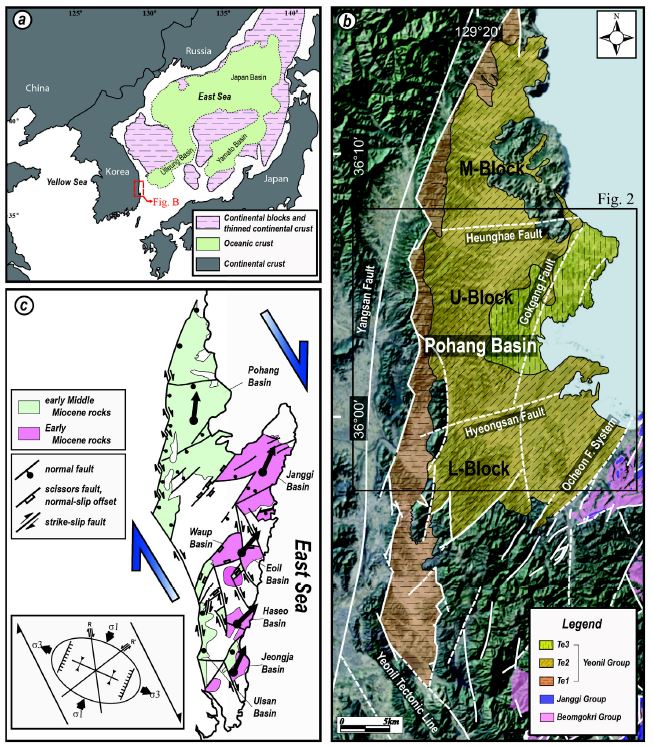
(a) Simplified tectonic map of the East Sea modified after Jolivet et al. (1991). (b) Landsat TM satellite image of the Pohang Basin showing the distribution of the Miocene sedimentary rocks and major faults (modified from Yun et al., 1991; Hwang et al., 1996; Son, 1998; Son et al., 2002, 2013; Cheon et al., 2012; Song et al., 2012) and (c) the regional structural map in SE Korea with the strain diagram during the East Sea opening. The thick black arrows indicate the mean declination directions of characteristic remanent magnetizations of the basin-fills. Te1: Conglomerate and sandstone, Te2: Mudstone with lenses of conglomerate and sandstone, Te3: Diatomaceous mudstone.
2. 지질학적 특성
2.1 일반지질
포항분지는 서쪽 경계단층에 인접하여 분포하는 선상지-삼각주계와 이를 피복하며 분지의 중앙부와 서부에 넓게 분포하는 해양 부유성의 미고결 퇴적물에 의해 채워져 있다(그림 1b; Yoon, 1975; Chough et al., 1990; Hwang, 1993; Noh, 1994; Hwang and Chough, 2000; Sohn et al., 2001). 충전물의 퇴적 시기는 고생물학적 연구들(Yoon, 1976a, 1976b; You et al., 1986; Kim, 1990, 1999; Byun and Yun, 1992; Yi and Yun, 1995)에 의해 전기 마이오세 말에서 중기 마이오세 말인 것으로 알려져 있다. 암층서는 Tateiwa (1924) 이래로 다수의 제안이 있었으나(Um et al., 1964; Kim, 1970; Yoon, 1975; Yun, 1986; Chough et al., 1990; Noh, 1994) 현재까지 통일되지 못하고 논란이 계속되고 있다.
대부분의 선행 연구들은 포항분지의 확장 형식으로 양산단층의 우수향 주향이동에 의한 당겨열림(pull- apart)형 확장을 제안하고 있다(Han et al., 1986; Chough et al., 1990; Kim, 1992; Hwang, 1993; Yoon and Chough, 1995; Choi, 2006). 그러나 이런 대다수의 제안과는 달리 일부 학자들은 포항분지 확장이 양산단층의 주향이동과는 무관함을 주장할 뿐만 아니라(Yun et al., 1991; Hong et al., 1998; Sohn and Son, 2004), 분지의 서쪽 경계는 양산단층이 아니라 보다 동편에 발달하는 수조의 지그재그 형태의 정단층과 이음단층(transfer fault)으로 이루어져 있으며(그림 1b), 동해 확장으로 야기된 북북서 방향의 우수향 전단력이 대륙 내로 전파되어 17 Ma 경에 우수향 주변위대(principal displacement zone)로 운동한 연일구조선에 의해 주도된 것으로 보고되고 있다(그림 1c; Sohn and Son, 2004; Son et al., 2007, 2013; Cheon et al., 2012).
한편, 포항분지의 기반암인 심부 화강암에 대한 열연대학적 연구결과(Shin and Nishimura, 1994)는 분지의 최대 침강 시기의 심도는 1,000 m 이내일 것으로 보고된 바 있으며, 이곳은 한반도 내에서도 가장 높은 지열류량(~89 mW/m2)과 지온구배(35~40℃/km)를 보이는 지역 중 하나로 알려져 있다(Lee et al., 2010; Song et al., 2010; Lee et al., 2011).
2.2 분지충전물의 퇴적학적 특성
포항분지 충전물의 층서는 뚜렷한 열쇠층의 부재와 암상 간 특성에 대한 견해차이로 인해 연구자에 따라 다양한 의견들이 제시되고 있지만, 분지 서편에 선상지-삼각주계 퇴적체가 먼저 형성되고 이후 중앙으로 가면서 천해성 사암과 이암 그리고 동편에 원양성 이암으로 시공간적으로 변화된다는 점에서는 공통된 견해를 보이고 있다(그림 1b). 이에 따라 분지 충전물의 층리는 대체로 동쪽으로 경사져 있으며, 서쪽 경계단층 인접부에서는 20~30° 내외의 상대적으로 고각의 경사를 보이는 역암 또는 역질 사암(Te1)이 우세하게 발달하는 반면, 동쪽으로 가면서 세립화되고(Te2와 Te3) 대체로 10° 미만의 얕은 지층경사를 보인다.
최근 포항분지 서편 경계단층을 따라 나타나는 선상지-삼각주계들 중에서 고주산과 도음산 지역에 대한 순차층서학적 연구를 살펴보면(Sohn and Son, 2004; Park et al., 2013), 각 선상지-삼각주계 퇴적물은 충적선상지, 하천성, 길버트형 선상지 등과 관련된 다양한 역암과 이들 사이에 협재된 사암 또는 천해성 이암 등으로 구성되는 5개의 상조합으로 구분된다. 특히 고주산 선상지-삼각주계의 경우에는 북북동 방향의 단층 주향을 따라 북부, 중앙부, 남부에서 측방으로 변화되는 상조합을 보여준다(그림 9 in Sohn and Son, 2004). 이는 분절된 정단층들 사이의 이음부(transfer zone)에서 대규모 퇴적물이 공급되어 단층의 상반으로 이동될 때 상반의 분지 기저가 평탄하지 않고 상당한 지형기복이 있었음을 지시한다(그림 2). 이러한 상반의 지형기복은 분절된 각 정단층의 중앙부에서 수직변위가 가장 크나 주향을 따라 측방으로 단층말단으로 갈수록 변위가 줄어들며(Schlische, 1992, 1993), 더불어 계속된 분지 확장으로 분지 내부에 새로이 만들어지는 퇴적동시성 정단층에 의한 지형기복이 원인인 것으로 판단된다. 분지 내부에 새로이 만들어지는 정단층의 상반 기저에는 단층애를 따라 기존의 역층이 재동(reworking)되어 새로운 조립질 퇴적체가 퇴적될 가능성이 높다(Sohn and Son, 2004).
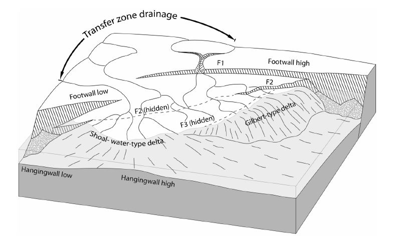
Three-dimensional block diagram showing the topographic relief around the transfer zone between two normal fault segments (from Sohn and Son, 2004). The delta system has a composite shoal water-type and Gilbert-type geometry because of its development near an intrabasinal transfer zone where the hangingwall relief is variable along the strike of the basin margin.
2.3 지질구조 특성
단층으로 구획된 포항분지는 북북동 쪽으로 벌어진 쐐기 형태의 구조분지로써(그림 1b), 서쪽으로는 북서 내지 북북서 방향의 이음단층으로 분절된 북북동 방향의 정단층들과 경주시 보문호에서 이와 연결되어 남남동 쪽으로 연장되는 연일구조선에 의해 경계되며, 동쪽으로는 여러 조의 북동 내지 북북동 방향 단층들이 다발을 이루는 오천단층계에 의해 경계된다(Cheon et al., 2012; Song et al., 2012; Son et al., 2013). 포항분지의 서편 경계단층은 지그재그 형태로 북북동 방향의 정단층 분절들이 좌향스텝(left-stepping)하는 구조를 보이며, 이들 사이의 이음단층 인접부에는 선상지-삼각주계 역암 및 역질 사암이 두껍게 퇴적되어 있다(Sohn and Son, 2004; Song et al., 2012; Son et al., 2013). 한편, 이 경계단층의 남단에서 연결되는 연일구조선은 한반도 남동부 전기 마이오세 지각변형을 규제한 서쪽 한계선으로 주향 변화에 따라 4개의 분절단층으로 구분된다(그림 1b). 이중 북북서 방향의 것은 우수향 주향이동단층 운동을 그리고 남북과 북북동 방향의 것들은 우수향 횡인장성 단층운동을 한 것으로 보고되어 있다(Son et al., 2002). 포항분지의 동편 경계인 오천단층계는 남서쪽으로 갈수록 변위량이 감소하는 가위단층의 기하를 가지며, 이들 중 규모가 가장 큰 단층이 장기분지와 포항분지의 경계를 이루고 있다(Cheon et al., 2012). 장기분지와 포항분지를 경계하는 단층은 전기 마이오세동안 장기분지의 서편 경계로써 정단층 운동을 하였으나, 마이오세 동안 지속된 우수향 전단응력 하에서 중기 마이오세에는 포항분지의 확장과 함께 시계방향의 회전운동을 겪으면서 좌수향 횡인장성 사교이동단층으로 재활된 것으로 알려져 있다(Cheon et al., 2012).
이들 분지 경계단층 인근에서 실시된 고응력장 복원 결과(Moon et al., 2000; Cheon et al., 2012; Song et al., 2012)와 분지 내부 해안가에서 얻어진 소규모 단층들의 기하와 운동학적 자료들을 분석한 결과(그림 3)는 모두 포항분지가 서북서-동남동 방향의 최소 수평주응력장(σ3) 하에서 확장되었음을 지시한다. 또한 분지 서편 경계단층과 연일구조선의 기하와 운동학적 특징 그리고 오천단층 동편의 지괴(구룡포 반도)의 시계방향 회전운동 등을 종합적으로 고려할 때, 포항분지는 강력한 우수향 전단력 하에서 동편의 회전되는 지괴와 서편의 회전되지 않는 지괴 사이에서 확장된 쐐기형 당겨열림분지(sphenochasm)로 해석된다(그림 1c; Son et al., 2013).
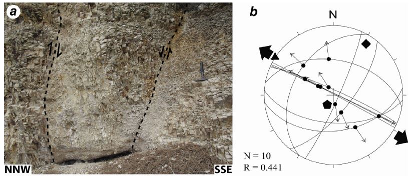
(a) Outcrop photograph showing a conjugate normal fault pair and (b) stereographic projection showing paleostress reconstruction calculated from slip data observed near F3 fault. Polygons: principal stress axes (pentagon=σ1, square=σ2, triangle=σ3). Divergent arrows indicate the direction of minimum horizontal stress (σHmin).
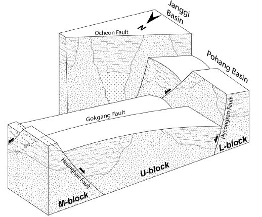
이러한 분지의 확장은 분지 내부에도 다수의 단층을 생성시켰다. Yun et al. (1991)은 야외조사, 시추조사, 고생물 그리고 중력탐사 등의 자료를 토대로, 포항분지는 내부에 발달하는 두 조의 공액상(conjugate) 동서 방향 정단층인 형산단층과 흥해단층에 의해 세 개의 지괴로 나누어지며(그림 1), 흥해단층 북쪽의 M-지괴와 형산단층 남쪽의 L-지괴는 단층하반에 해당하고 두 단층 사이의 U-지괴는 가장 깊은 침강을 겪은 상반에 해당하는 것으로 해석하였다. 더 나아가 Yun (1994)은 포항분지 동부에서 북북동 주향에 동쪽으로 경사지고 U-지괴와 L-지괴를 절단하는 곡강단층의 존재를 보고하였다(그림 4). 한편, Sohn and Son (2004)는 고주산 선상지-삼각주계의 퇴적상과 구조분석을 통하여 분지 내부에 동쪽으로 경사진 퇴적 동시성 정단층 운동이 최소 3회 이상 동편으로 점진적으로 이동하면서 발생하였음을 보고하였다. 따라서 포항분지의 기저는 전반적으로 동쪽으로 갈수록 깊어지며, 특히 U-지괴의 동부 해안가에서 가장 깊은 심도를 가질 것으로 예상된다. 그러나 이러한 분지 내부 단층들은 퇴적 동시성 성장단층의 특징을 가지고 있어 후기 원양성 부유 퇴적물에 의해 매몰되어 대부분 야외에서 노두로 관찰되지는 않는다.
3. 대심도 시추공 분석
1970년대 말에 석유와 가스전 탐사와 관련되어 포항분지를 대상으로 18개소에서 대심도 시추조사가 수행되었다. 또한, 2003년부터 포항시 흥해읍 남부에서 심부 지열에너지 개발을 위해 4개소, 2011년부터 이산화탄소 지중저장 사업과 관련하여 4개의 대심도 시추가 추가되었다(그림 5, 6). 총 26개 시추공 중 2개(201과 TB2공)를 제외하고 모든 시추공에서 분지의 기반암까지 시추가 완료되었다. 따라서 이들 시추공의 기반암 심도 분포를 이용하여 분지 기저의 기하를 유추하였으며 이를 앞서 제시된 분지의 구조 모델(그림 4)과 비교·분석하였다.
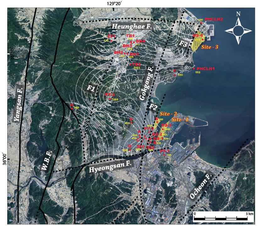
Depth (yellow numbers) distribution map of the basement in the U-block of the Pohang Basin, determined using 26 deep drilling boreholes, shows major faults and three potential CO2 storage sites (yellowish areas). Contour lines, derived from kriging method using the basement depths, show the depth distribution of the basin floor. The red characters and/or numbers represent the borehole names. W.B.F.: the western border fault of the Pohang Basin.
시추조사는 대부분 Yun et al. (1991)에 의해 제시된 U-지괴에 집중되어 수행되었으며, 특히 지괴의 남동부 시가지에 밀집되어 있다(그림 5). 기반암의 심도분포를 자세히 살펴보면, 전반적으로 분지의 서쪽에서 동쪽으로 갈수록 깊어지나 특정 시추공 사이에서 심도가 급격히 깊어졌다가 일정 구간 점차 얕아지다 다시 급격히 깊어지는 경향이 반복적으로 나타나는 특징을 보인다(그림 6). 이와 같은 동서 방향의 기반암 심도 변화와 함께, 흥해단층과 인접한 북부보다는 형산단층과 인접한 남쪽으로 갈수록 기반암의 심도가 깊어지는 남북 방향의 변화도 인지된다. 위 결과를 종합해 볼 때, 포항분지의 기저 심도는 U-지괴 중에서도 남동부 일대가 800 m 이상으로 가장 깊다고 할 수 있다.
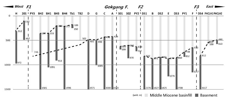
Simplified borehole logs showing abrupt changes of the basement depths along east-west direction and correlated with locations of faults. Borehole localities are the same as Fig. 5.
U-지괴의 기반암 심도가 서에서 동으로 깊어지는 특징은 포항분지에 대한 기존 연구결과로 잘 설명될 수 있다. 지질구조 분석에 의해(Cheon et al., 2012; Song et al., 2012; Son et al., 2013; 그림 3), 포항분지의 확장방향은 서북서-동남동 방향으로 북북동 주향에 동쪽으로 경사진 정단층들에 의해 분지의 확장이 주도된 것으로 알려져 있다. 이러한 정단층은 분지 경계뿐만 아니라 내부에도 존재하며(Yun, 1994), 분지 내부의 정단층들은 분지가 확장되는 동안 서쪽으로 위치가 이동되면서 새로이 만들어진 것으로 해석된 바 있다(Sohn and Son, 2004). 즉, 분지의 서편에 비해 동편에서 오랜 기간 지속적인 지각 침강이 발생하여 분지의 퇴적심(depocenter)이 확장 과정에서 동쪽으로 이동된 것으로 해석된다. 따라서 분지 내 기반암의 심도가 급격히 하강하는 시추지점 사이에는 퇴적동시성 정단층이 위치할 것으로 판단된다. 이러한 해석은 기존에 알려져 있는 곡강단층과 인접한 양편 시추공의 기반암 심도가 뚜렷한 차이를 보여주고 있어 지지된다(그림 5, 6).
이번 연구에서는 이러한 갑작스런 기반암 심도의 차이에 근거하여 곡강단층뿐만 아니라 이 단층의 동편과 서편에 각각 한 개(F1)와 두 개의 단층(F2와 F3)이 지하에 존재할 것으로 추정하였다. 따라서 포항분지 U-지괴 내에는 최소 4개의 북북동 방향 퇴적동시성 정단층이 존재하며, 이로 인해 동편으로 갈수록 분지의 심도가 점차 깊어지는 것으로 해석된다. 특히, F3 단층은 최근 이산화탄소 지중저장소 선정을 위해 실시된 PHCLH2 공의 심도 490 m 지점부터 산출되는 기반암 내 단층파쇄대(그림 7a)와 이 단층을 가로지르며 실시된 MT 탐사에서 얻어진 고각의 이상대로 그 존재가 확인되고 있다(Kim, 2013). 또한 F3 단층의 서편과 동편에서 얻어진 충전물의 층리의 주향도 각각 동북동과 북북동으로 큰 차이를 보여주고 있어 지하 단층의 존재를 지지해준다(그림 7b).
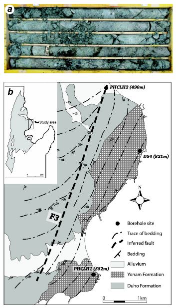
(a) Deep-drilling core photograph of PHCLH2 showing the fault damage zone of F3. The highest stratigraphic position is in the upper left corner of box. (b) Geologic map in the vicinity of F3 showing the significant distinction of bedding traces between western and eastern blocks of the F3.
시추공 자료에 의하면 단층선 근처에서 분지 기저 심도가 갑자기 깊어지다 동편으로 가면 점차 심도가 완만히 얕아지는 양상이 반복된다(그림 6). 이는 지하에 존재하는 정단층들이 동쪽으로 경사진 점완(listric) 또는 서가형(bookshelf) 정단층이며, 단층운동과 함께 상반에 해당하는 기반암 지괴가 서북서 방향으로 경동(tilting)되었을 가능성을 지시해 준다. 열개(rift) 또는 당겨열림형 분지들에서 점완/서가형 단층운동에 의해 지괴가 확장방향과 평행한 방향으로 경동되는 현상은 전 세계적으로 흔히 보고되며(Wernicke, 1981; Schlische, 1992, 1993; Wise, 1992; Scott et al., 1994), 포항분지보다 남쪽에 위치하는 우리나라 전기 마이오세 분지들에서도 널리 보고된 바 있다(Son and Kim, 1994; Son et al., 2000a, 2000b; Cheon et al., 2012).
한편, U-지괴의 기반암 심도는 형산단층과 인접한 남부로 갈수록 보다 깊어지는 경향을 보이는데(그림 5), 이는 흥해단층과 형산단층의 변위차이에 기인하는 것으로 판단된다. 대심도 시추공과 지표에서 산출되는 미화석을 이용하여 지층을 지괴 간에 대비한 연구결과에 의하면(Yun et al., 1991), 형산단층 남쪽의 L-지괴에서 가장 오래된 화석군이, 다음으로 흥해단층 북쪽의 M-지괴에서 오래된 화석군이 그리고 형산단층과 흥해단층 사이의 U-지괴에서 가장 젊은 화석군이 지표에서 관찰됨을 보고하고 있다. 이러한 결과는 상대적인 침강량이 U-지괴가 가장 컸으며 다음으로 M-지괴 그리고 L-지괴가 가장 적은 침강을 겪었음을 의미한다. 즉, 흥해단층에 비해 형산단층의 수직변위가 보다 컸으며, 이로 인해 U-지괴의 남부가 북부에 비해 분지의 기저 심도가 깊은 특징을 보일 가능성이 높다.
4. 이산화탄소 지중저장을 위한 조건
4.1 물리·화학적 조건
지중저장을 위한 이산화탄소는 초임계상태(su-percritical phase)를 유지함으로써 효율을 극대화할 수 있다. 초임계 유체란 임계점 이상의 온도와 압력 상태에서 존재하는 유체로 분자 밀도가 액체에 가까워 부피는 감소시키면서 점도는 기체에 가까워 빠른 확산을 기대할 수 있다. 이산화탄소의 경우 임계점은 온도 31.1℃(304.25 k), 압력 7.39 Mpa (72.9 atm)으로써 포항분지에서 이에 해당하는 지하 환경에 대해서는 Han et al. (2012)에서 자세히 논의되었으며 아래는 그 내용이다.
Koo et al. (2006)에서 제시된 포항지역 연평균지면온도(annual mean ground surface temperature; MGST)는 15.79℃로 제시되었다. 이에 포항분지의 지온구배의 평균값 37.5℃(Song et al., 2010)을 고려하면 포항분지에서 심도(Z)에 따른 온도(Tz)는 식 1과 같이 구할 수 있다.
| (식 1) |
심도에 따른 압력의 경우 정수압 상황을 가정하면 압력구배는 10 Mpa/km로 산정할 수 있다. 이때 심도(Z)에 따른 압력(Pz)은 식 2와 같이 구할 수 있다.
| (식 2) |
두 식을 바탕으로 이산화탄소의 임계점을 초과하는 심도를 산출하면 740 m라는 결과를 도출할 수 있다. 이는 대심도 시추 결과에서 보이는 포항분지 기저까지의 심도 분포(그림 5)와 비교할 때 수용 가능한 범위에 해당된다.
4.2 지층 특성화
포항분지 내 기반암이 740 m 보다 깊은 심도에 존재하더라도 실제 이산화탄소 지중저장을 위해서는 저장층이 이 심도보다 깊은 곳에 존재하는가와 주입 이후 지표로 상승하는 이산화탄소의 차폐막 역할을 할 덮개층의 유무가 중요하다. 이산화탄소 지중저장을 위한 최소한의 심도를 만족하는 곳은 U-지괴의 F2와 F3 단층의 동편 해안가 지역이 해당되며, 이곳 시추공 상에서 나타난 분지 기저의 심도는 812~889 m 범위를 보인다. 이 지역 내에 위치하는 B와 E공의 기존 연구는 역질 또는 사질의 육성 퇴적물이 기반암 상부에 200 m 이상의 두께로 퇴적되어 있음을 보고하고 있다(Yi and Yun, 1995). 이 구간에 대한 보다 정밀한 주상도를 작성한 결과(그림 8), B공은 875~795 m 구간에서 약 70%가 역암 또는 역질 사암(그림 9a)으로 구성되어 있으며 그 상부는 두꺼운 암회색 또는 자색의 이암에 의해 피복된다. E공의 경우는 889~725 m 구간에서 약 90%가 역암(그림 9b)으로 구성되어 있으며 그 상부에는 역암, 역질 사암, 이암이 호층을 이루다 두꺼운 이암으로 피복된다. 이러한 기저의 조립질 퇴적암의 분포는 지중저장을 위한 심도조건을 만족하는 유망 저장층이 포항분지 내에 존재함을 의미한다. 또한 이를 지표까지 700 m 이상 두껍게 피복하고 있는 이암층은 덮개층으로서 매우 유망하다 할 수 있다.
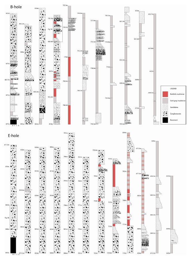
Columnar sections of B and E boreholes showing thick conglomerates and intercalated sandstones accumulated on the bottom of the Pohang Basin.
저장층의 경우 높은 공극률과 투수율을 가져야 하고 덮개층은 낮은 투수율이 필수적이다. 지표에 드러난 유망 저장층은 주로 선상지-삼각주계 퇴적층으로 분지의 서편경계단층을 따라 노두로 직접 관찰할 수 있다. 이들은 조립질일 뿐만 아니라 미고결 상태로 산출되어 육안으로 보아도 높은 공극률과 투수율이 기대된다. 시추공에서 관찰되는 기저의 조립질 암체의 경우에도 북북동 방향 정단층의 상반에 두껍게 나타나고 있어 노두에서 관찰되는 퇴적 시스템과 유사하게 단층운동에 따른 지형기복(단층애)을 따라 운반되어 퇴적된 것으로 판단된다. 분지 내 지하 단층의 규모는 서쪽 경계단층에 비해 훨씬 작으며, 실제 시추조사에서 지하 조립질 암체는 단층의 주향을 따라 기반암의 심도가 얕아질수록 두께가 얇아지는 특징을 보인다. 이는 이 암체가 지표의 것에 비해 연장성이 좋지 않음을 의미하며, 수직변위가 상대적으로 가장 큰 지하 정단층의 중앙부 상반에 고립되어 두껍게 분포할 가능성이 높다(그림 10). 한편, 덮개층으로써 조립질 암체를 피복하는 이암층은 분지 동편 해안가에서 약 700 m의 두꺼운 두께를 가지며 야외 및 시추조사에서 양호한 측방 연속성을 보여 분지 내부 단층들까지 대부분 피복할 것으로 예상된다. 또한 매우 세립질로 낮은 투수율이 기대되어 상대적으로 고립된 조립질 암체의 상부 전체를 덮는 훌륭한 층서 트랩을 형성할 것으로 판단된다. 실제로 PHCLH1 공에서 측정된 역암 및 사암과 이암의 공극률(Han et al., 2012; Kim, 2013; KIGAM, 2014)은 20~35%로 유사한 범위를 가진다. 반면, 투수율의 경우 역암 및 사암은 예외적으로 0.008 mD의 낮은 값도 있으나 111~136 mD으로 높은 범위를 보이며 이암은 0.01~0.4 mD로 상대적으로 모두 낮은 값이 보고된 바 있다. 현재 세계적으로 염대수층을 대상으로 지중저장이 수행되고 있는 저장층의 공극률은 5~34%, 투수율은 5~5,000 mD에 범위에 해당하고 있어(Michael et al., 2010), 포항분지의 조립질 암체는 대체로 이 저장층의 범위 내에 해당되며 이암의 경우에도 낮은 투수율로 덮개층으로 만족스러운 값을 보여주고 있다.
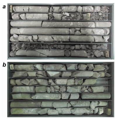
Deep-drilling core photographs of B- (a) and Eboreholes (b) consisting of conglomerates and intercalated sandstones. The highest stratigraphic position is in the upper left corner of boxes.
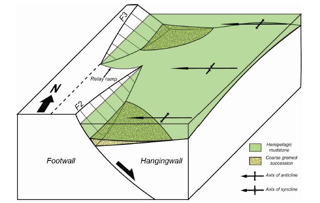
Schematic block diagram showing the topographic relief of the eastern part of the Pohang Basin floor developed due to the relayed NNE-trending normal faulting. Note that permeable coarse grained successions overlain by impermeable thick mudstones are isolated in the central part of hanging wall because of its maximum vertical displacement.
5. 유망후보지역에 대한 제언과 결론
포항분지 심부 대염수층을 이용한 파일럿 규모의 이산화탄소 지중저장 유력 후보지를 선정하기 위해 구조지질, 퇴적학, 대심도 시추, MT 탐사 그리고 대상 지층에 대한 수리적 특성 등의 자료를 종합적으로 분석하였다. 이를 통해, 포항분지는 북북동 방향 서편 경계단층의 정단층 운동에 의해 확장이 시작되었으며, 동일한 방향의 수매의 단층들이 서쪽으로 이동하며 새로이 생성되는 과정을 겪으면서 분지의 동편으로 갈수록 심도가 깊어진 것으로 해석된다. 또한 분지를 동서로 가르는 공액상 정단층에 의해 분지의 북부와 남부에 비해 중앙부(U-지괴)가 가장 깊이 침강하였으며 특히, 이 지괴의 F2와 F3 단층의 동편 해안가의 분지 심도가 이산화탄소 초임계상태의 한계인 740 m를 초과할 뿐만 아니라 이 심도보다 깊은 곳에 저장층으로 유망한 역암 및 사암의 조립질 암체가 존재함이 확인되었다. 또한 이 조립질 암체는 700 m 이상 두꺼운 이암층에 의해 피복되고 있어 이산화탄소 지중저장 후에 지상으로의 누출을 막을 수 있는 층서 트랩이 형성되어 있는 것으로 판단된다.
위 연구결과를 바탕으로 본 연구에서는 포항분지 내에 3개 지점의 이산화탄소 지중저장 유망 후보지를 선정하였다(그림 5). 이들 지점은 지질학적, 물리․화학적 조건들을 만족시킬 뿐 아니라, 인접지역에 POSCO와 같은 대규모 이산화탄소 발생원이 위치하고 있어 지리적 이점까지 가진다. 한편, 지점 1(제철동)과 2(송도동)에는 각각 주택 및 상업지구와 산업시설이 형성되어 있어 부지 특성화 조사/탐사 및 분석 연구에 불리한 반면, 지점 3(우목리)은 저개발 지역으로 지점 1과 2에 비해 부지 특성화 및 선정 연구에 상대적으로 용이하다. 그러나 지점 3 일원에 대한 정밀 지질 조사결과, 덮개층으로 평가되는 F3 단층의 양편에 분포하는 이암층의 층리 자세가 확연히 다르고 이암층을 절단하는 소규모 단층과 습곡들이 관찰되어 있어(그림 7) 지하의 퇴적동시성 정단층(F3)이 후기 응력장 하에서 재활(reactivation)하였을 가능성이 높다. 따라서 이 지역에 대한 추가 정밀 조사가 반드시 필요하며, 이를 통해 상세 지층 특성화를 통한 저장용량 평가와 함께 이산화탄소 지중저장 이후 후기 단열들을 통로로 하는 누출에 대한 평가도 이루어져야 할 것으로 판단된다. 또한 인근 해상 지역의 심부에 분포하는 포항분지의 지층과 지질구조에 대한 연구가 전무하기 때문에 향후 연구는 해상 포항분지의 지중저장 유망성을 조사하고 평가하는 방향으로 수립될 필요가 있다.
Acknowledgments
본 연구는 한국지질자원연구원 주관의 ‘이산화탄소 지중저장 실증을 위한 저장지층 특성화 및 기본설계 기술개발(GP2012-03)’ 과제와 2014년도 정부(미래부)의 재원으로 (재)한국이산화탄소 포집 및 처리 연구개발센터의 지원(NRF-2014M1A8A1049339)을 받아 수행된 연구이다. 심사과정에서 유익한 조언을 주신 공주대학교 권이균 교수님과 KINS 이현우 박사님께 깊이 감사드린다.
REFERENCES
- Byun, H.S., and Yun, H.S., (1992), Miocene Dinoflagellate Cysts from the central part of the Pohang Basin, Korea, Journal of the Paleontological Soceity of Korea, 8, p164-235.
-
Cheon, Y., Son, M., Song, C.W., Kim, J.-S., and Sohn, Y.K., (2012), Geometry and kinematics of the Ocheon Fault System along the boundary between the Miocene Pohang and Janggi basins, SE Korea, and its tectonic implications, Geosciences Journal, 16, p253-273.
[https://doi.org/10.1007/s12303-012-0029-0]

-
Choi, P.Y., (2006), 'Singwang strike-slip duplex' around the Pohang Basin, SE Korea: its structural evolution and role in opening and fill of the Miocene basin, Geosciences Journal, 10, p145-157.
[https://doi.org/10.1007/BF02910359]

- Chough, S.K., Hwang, I.G., and Choe, M.Y., (1990), The Miocene Doumsan Fan-delta, South Korea: A composite fan-delta system in back-arc margin, Journal of Sedimentary Petrology, 67, p130-141.
- Han, J.H., Kwak, Y.H., and Son, J.D., (1986), Tectonic evolution and depositional environments of the Tertiary sedimentary basin, KIER Report KR-86-(B)-8, p76, (in Korean with English abstract).
- Han, R., Kim, C.-M., Song, C.W., Cho, H., Ghim, Y.-S., Son, M., and Sohn, Y.K., (2012), Geological storage of CO2 in the Pohang Basin: Preliminary discussion based on geological structures and hydraulic properties of sedimentary deposits, Fall joint annual conference of the geological societies in Korea (Abstracts), Jeongseon, October 24-27, 102, (in Korean).
-
Hong, S.W., Chough, S.K., and Hwang, I.G., (1998), Provenance of coarse-grained detritus in fan-delta systems, Miocene Pohang Basin, SE Korea: Implication for boundary fault movements, Geosciences Journal, 2, p46-58.
[https://doi.org/10.1007/BF02910203]

-
Hwang, I.G., and Chough, S.K., (2000), The Maesan Fan delta, Miocene Pohang Basin, SE Korea: architecture and depositional processes of a high-gradient fan-delta-fed slope system, Sedimentology, 47, p995-1010.
[https://doi.org/10.1046/j.1365-3091.2000.00335.x]

- Hwang, I.G., (1993), Fan-Delta systems in the Pohang Basin (Miocene) SE Korea, Ph.D. these, Seoul National University, Seoul, p923.
- Hwang, J.H., Kim, D.H., Cho, D.R., and Song, K.Y., (1996), Explanatory note of the Andong Sheet, Korea Institute of Geology, Mining & Materials, Teajon.
- IEA, (2008), Energy technology perspectives, Technical report, International energy agency (IEA), Paris, France, p643.
-
Jolivet, L., Huchon, P., and Brun, J.P., (1991), Arc deformation and marginal basin opening: Japan Sea as a case study, Journal of Geophysical Research, 96, p4367-4384.
[https://doi.org/10.1029/90JB02455]

- Kim, B.K., (1970), A study on the Neogene Tertiary deposits in Korea, Journal of Geological Society of Korea, 6, p77-96, (in Korean with English abstract).
- Kim, I.-S., (1992), Origin and tectonic evolution of the East Sea (Sea of Japan) and the Yangsan Fault System: A new synthetic interpretation, 28, p84-109, (in Korean with English abstract).
- KIGAM, (2014), Characterization of storage strata and development of basis design technology for demonstration of CO2 geological storage, Korea Institute of Geology, Mining & Materials, GP2012-030-2014(2), p441.
-
Kim, J.-M., (1999), Early Neogene biochemostratigraphy of Pohang Basin: a paleoceanographic response to the early opening of the Sea of Japan (East Sea), Marine Micropaleontology, 36, p269-290.
[https://doi.org/10.1016/S0377-8398(99)00006-7]

- Kim, T., (2013), The comparison of geologic features in Pohang Basin with site selection guideline by FutureGen2.0, International Workshop on Structural de-risking of CO2 sequestration sites, Busan, South Korea, Feb. 19-20, Part 6.
- Kim, W.H., (1990), Significance of early to middle Miocene planktonic foraminiferal biostratigraphy of the E-core in the Pohang Basin, Korea, Journal of Paleontaological Society of Korea, 6, p144-164.
- Koo, M.-H., Song, Y., and Lee, J.-H., (2006), Analyzing spatial and temporal variation of ground surface temperature in Korea, Korea Institute of Geoscience and Mineral Resources, 39, p255-268, (in Korean with English abstract).
- Lee, T.J., Yoon, Y., Yoon, W.S., Kim, K.-Y., Jeon, J., and Min, K.-B., (2011), The first exhanced geothermal system project in Korea, The 9th Asian Geothermal Symposium, Kagoshima, Japan, November 7-9, p129-132.
-
Lee, Y., Park, S., Kim, J., Kim, H.C., and Koo, M.-H., (2010), Geothermal resource assessment in Korea, Renewable and Sustainable Energy Reviews, 14, p2392-2400.
[https://doi.org/10.1016/j.rser.2010.05.003]

- Metz, B., Davidson, O., Coninck, H.C., Loos, M., and Meyer, L.A., (Eds.) , (2005), Intergovernmental panel on climate change special report on carbon dioxide capture and storage, Cambridge University Press, New York, USA, p442.
-
Michael, K., Golab, A., Shulakova, V., Ennis-King, J., Allinson, G., Sharma, S., and Aiken, T., (2010), Geological storage of CO2 saline aquifers -A review of the experience from existing storage operations, International Journal of Greenhouse Gas Control, 4, p659-667.
[https://doi.org/10.1016/j.ijggc.2009.12.011]

- Moon, T.-H., Son, M., Chang, T.-W., and Kim, I.-S., (2000), Paleostress reconstruction in the Tertiary basin areas in Southeastern Korea, Journal of Korean Earth Science Society, 21, p230-249, (in Korean with English abstract).
- Noh, J.H., (1994), Stratigraphy, lithology and diagenetic mineral facies of the tertiary Yeonil Group, Journal of the Petrological Society of Korea, 2, p91-99, (in Korean with English abstract).
-
Park, M.E., Cho, H., Son, M., and Sohn, Y.K., (2013), Depositional processes, paleoflow patterns, and evolution of a Miocene gravelly fan-delta system in SE Korea constrained by anisotropy of magnetic susceptibility analysis of interbedded mudrocks, Marine and Petroleum Geology, 48, p206-223.
[https://doi.org/10.1016/j.marpetgeo.2013.08.015]

-
Schlische, R.W., (1992), Structural and stratigraphic development for the Newark extensional basin, eastern North America: Evidence for the growth of the basin and its bounding structures, Bulletin of the Geological Society of America, 104, p1246-1263.
[https://doi.org/10.1130/0016-7606(1992)104<1246:SASDOT>2.3.CO;2]

-
Schlische, R.W., (1993), Anatomy and evolution of the Triassic-Jurassic continental rift system, eastern North America, Tectonics, 12, p1026-1042.
[https://doi.org/10.1029/93TC01062]

-
Scott, D.L., Braun, J., and Etheridge, M.A., (1994), Dip analysis as a tool for estimating regional kinematics in extensional terranes, Journal of Structural Geology, 16, p393-401.
[https://doi.org/10.1016/0191-8141(94)90043-4]

- Shin, S.-C., and Nishimura, S., (1994), Thermotectonic and sedimentation history of the Pohang Basin, Korea assessed by fission track thermochronology of a deep borehole granite, Korean journal of Petroleum Geology, 2, p9-17.
-
Sohn, Y.K., and Son, M., (2004), Synrift stratigraphic geometry in a transfer zone coarse-grained delta complex, Miocene Pohang Basin, SE Korea, Sedimentology, 51, p1387-1408.
[https://doi.org/10.1111/j.1365-3091.2004.00679.x]

-
Sohn, Y.K., Rhee, C.W., and Shon, H., (2001), Revised stratigraphy and reinterpretation of the Miocene Pohang basinfill, SE Korea: sequence development in response to tectonism and eustasy in a back-arc basin margin, Sedimentary Geology, 143, p265-285.
[https://doi.org/10.1016/S0037-0738(01)00100-2]

- Son, M., and Kim, I.-S., (1994), Geological structures and evolution of the Tertiary Chongja basin, southeastern margin of the Korean peninsula, Economic and Environmental Geology, 27, p65-80, (in Korean with English abstract).
- Son, M., (1998), Formation and evolution of the Tertiary Miocene basins in southeastern Korea: Structural and paleomagnetic approaches, Ph.D. Thesis, Pusan National University, Busan, p233, (in Korean with English abstract).
- Son, M., Chong, H.-Y., and Kim, I.-S., (2002), Geology and geological structures in the vicinities of the southern part of the Yonil Tectonic Line, ES Korea, Journal of the Geological Society of Korea, 38, p175-197, (in Korean with English abstract).
- Son, M., Kim, I.-S., Lee, D., Lee, J.-D., Kim, J.S., and Paik, I.S., (2000a), Geological characteristics in the eastern part of the Ulsan fault area, Korea: Structural Geology and Anisotropy of Magnetic Susceptibility (AMS) in the Tertiary Miocene Waup basin, Journal of the Geological Society of Korea, 36, p195-216, (in Korean with English abstract).
- Son, M., Kim, J.-S., Chong, H.-Y., Lee, Y.H., and Kim, I.-S., (2007), Characteristics of the Cenozoic crustal deformation in SE Korea and their implications, Korean journal of Petroleum Geology, 13, p1-16, (in Korean with English abstract).
-
Son, M., Seo, H.J., and Kim, I.-S., (2000b), Geological structures and evolution of the Miocene Eoil basin, southeastern Korea, Geosciences Journal, 4, p73-88.
[https://doi.org/10.1007/BF02910128]

- Son, M., Song, C.W., Kim, M.-C., Cheon, Y., Jung, S., Cho, H., Kim, H.-G., Kim, J.S., and Sohn, Y.K., (2013), Miocene crustal deformation, basin development, and tectonic implication in the Southeastern Korean Peninsula, Journal of the Geological Society of Korea, 49, p93-118, (in Korean with English abstract).
- Song, C.W., Son, M., and Sohn, Y.K., (2012), Geometry and kinematics of the western marginal faults of the Miocene Pohang basin, SE Korea, and their tectonic implications, AOGS-AGU (WPGM) Joint Assembly, Singapore, August 13-17, p241.
- Song, Y., Kim, H.-C., and Lee, T.J., (2010), Geothermal Development in Korea: Country Updata 2005-2009, World Geothermal Congress 2010, Bali, Indonesia, April 25-29, p1-11.
- Tateiwa, I., (1924), Geological atlas of Chosen, no. 2: Ennichi-Kyuryuho and Choyo Sheet (1:50,000), Geological Survey of Chosen, p16, (in Japan).
- Um, S.H., Lee, D.W., and Park, B.S., (1964), Geological map of Korea, Pohang Sheet (1:50,000), Geological Survey of Korea, p21, (in Korean with English abstract).
-
Wernicke, B., (1981), Low-angle normal faults in the Basin and Range Province: nappe tectonics in an extensional orogen, Nature, 291, p645-648.
[https://doi.org/10.1038/291645a0]

-
Wise, D.U., (1992), Dip Domain Method Applied to the Mesozoic Connecticut Valley Rift Basins, Tectonics, 11, p1357-1368.
[https://doi.org/10.1029/92TC01103]

- Yi, S., and Yun, H., (1995), Miocene calcareous nannoplankton from the Pohang Basin, Korea, Palaeontographica Abteilung B, 237, p113-158.
-
Yoon, S.H., and Chough, S.K., (1995), Regional strike slip in the eastern continental margin of Korea and its tectonic implications for the evolution of Ulleung Basin, East Sea (Sea of Japan), Geological Society of America Bulletin, 107, p83-97.
[https://doi.org/10.1130/0016-7606(1995)107<0083:RSSITE>2.3.CO;2 ]

- Yoon, S., (1975), Geology and paleontology of the Tertiary Pohang Basin, Pohang district, Korea, Part1. Geology, Journal of Geological Society of Korea, 11, p187-214.
- Yoon, S., (1976a), Geology and paleontology of the Tertiary Pohang Basin: Part 2, Paleontology (Mollusca), No. 1, Systematic description of Bivalvia, The Journal of the Geological Society of Korea, 12, p1-22.
- Yoon, S., (1976b), Geology and paleontology of the Tertiary Pohang Basin, Pohang District, Korea. Part 2, Paleontology (Mollusca), No 2, Systematic description of Scaphopoda and Gastropoda with descriptions of fossil localities, The Journal of the Geological Society of Korea, 121, p63-78.
- You, H.S., Koh, Y.K., and Kim, J.Y., (1986), A study on the Nannoplankton from the Neogene formation, Pohang, Korea, Journal of Paleontaological Society of Korea, 2, p137-154.
- Yun, H.S., (1986), Emended stratigraphy of the Miocene formations in the Pohang basin, Part I, Journal of Paleontological Society of Korea, 2, p54-69.
- Yun, H.S., (1994), Emended Stratigraphy of the Miocene formations in the Pohang Basin, Part II: South of the Hyongsan Fault, Journal of the Paleontological Society of Korea, 10, p99-116.
- Yun, H.S., Min, K.D., Moon, H.-S., Lee, H.K., and Yi, S. S., (1991), Biostratigraphic, chemostratigrapic, paleomagnetostratigraphic, and tephrochronological study for the correlation of Tertiary formations in southern part of Korea: Regional tectonics and its stratigraphical implication in the Pohang Basin, Korea, Journal of Paleontological Society of Korea, 7, p1-12.
