MUSLE를 이용한 표토침식 위험성 분석: 지리산 국립공원 중산리 일대 사례연구
초록
본 연구에서는 지리산 국립공원내 유역을 대상으로 SWAT (Soil and Water Assessment Tool) 모형의 MUSLE (Modified Universal Soil Loss Equation) 산정식을 이용하여 각 사면단위의 수문반응단위(Hydrologic Response Unit, HRU)별 토양유실량을 계산하고, GIS를 이용하여 토양유실량을 표토침식 위험도로 표현하였다. 또한 SWAT을 이용하여 유량을 모의하였고, 실측유량으로 이를 검증하였다. 입력자료는 기상자료, 유량자료, 지형도, 토양도 및 임상도 등을 사용하였다. 산지 유역의 침식 특성을 반영하기 위해 사면단위를 소유역이 아닌 HRU를 설정하였고, 산지 유출인자와 지형인자를 모두 고려한 MUSLE를 적용하였다. 그 결과 토양유실량이 높은 지역은 근산통과 석고통이 분포하는 곳으로 나타났다. 모의유량의 검증결과 모의값과 실측값에 대한 R2와 NSE는 모두 0.8로 좋은 성능을 보였다. 본 연구에서는 연구지역을 소유역이 아닌 HRU 레벨로 나누어 분석하였기 때문에 사면관리에 더 효과적일 수 있다. 또한, 토양유실량과 잠재적 표토침식 위험도를 공간적으로 파악함으로써 토양생태계의 지속적인 보전과 더불어 토양유실 방지 계획을 수립하기 위한 기초자료제공에 그 목적이 있다.
Abstract
This study simulated the soil-loss yields of a catchment in Mt. Jiri National Park at the hillslope hydrologic response unit (HRU) spatial level using the Modified Universal Soil Loss Equation (MUSLE) in the Soil and Water Assessment Tool (SWAT). Furthermore, topsoil-erosion risk was mapped using GIS based on the simulated soil-loss yields. Discharge was analyzed using SWAT and validated against measured station data for the validation period. The input data were AWS data, discharge data, and a digital elevation map (DEM), soil map, and forest map. To reflect the erosion characteristics of the hillslope basin, the hillslope unit was subdivided into HRUs, rather than using the coarser sub-basin level. MUSLE was applied considering both hillslope runoff and topographic factors. As a result, the areas with potentially high soil loss were those where Seogto and Geunsan soils were distributed on the soil map. In the validation of the simulated discharge, both the R2 and Nash-Sutcliffe efficiency (NSE) values for the simulated and measured discharge values were 0.8, indicating good performance. The results of this study can promote more effective slope management in the study area because the slope was divided at the HRU level rather than the sub-basin level. In addition, major objectives of this study were to determine amounts of soil loss and potential risks of topsoil erosion spatially, to provide basic data for establishing a soil-loss prevention plan and continuous conservation of the soil ecosystem.
Keywords:
SWAT, MUSLE, GIS, topsoil erosion, soil loss키워드:
표토침식, 토양유실1. 서 론
토양은 생태계의 필수물질로 인간에게 식량생산의 기반이며 각종 산업원료의 공급으로 인류가 발전하는데 매우 중요한 역할을 했다. 하지만 전 세계적으로 기후변화로 인해 강우 강도와 빈도가 증가되고 있어 토양침식 속도가 증가되고 있다(Zhang et al., 2005; Chiang et al., 2021; Kim et al., 2021b, 2021c). 특히 산지내 표토침식은 여름철 집중호우 및 게릴라성 폭우가 다수 발생되는 시점에서 빠르게 진행되고 있다(Bae et al., 2020). 강우량 증가로 표토침식이 심화될 경우 토사유출 및 사면붕괴로 산사태를 유발 시킬 수 있다(Tomoyasu et al., 1995; Wei et al., 2007; Kim et al., 2020b).
우리나라는 국토의 약 64%가 산지로 이루어져 있고, 대부분의 국립공원은 산지에 위치해있다. 국립공원은 동·식물과 같은 자연생태계와 문화, 경관 등의 인문사회자원의 보고로써, 우리나라의 대표적인 휴양자원으로 여겨지고 있다(Sim and Lee, 2010). 하지만 집중호우로 산지내 유출된 토양은 탐방객들의 안전을 위협하고, 동식물의 서식공간의 파괴할 수 있다. 또한 계류, 지류, 하천 및 농수로내 퇴적되어 물의 흐름을 막아 통수능력을 저하시키고, 수질을 악화시킬 수 있다(Kim et al., 2021a). 그러므로 표토침식으로 인한 문제를 체계적으로 관리하기 위해서는 표토침식의 발생원인 및 규모에 대한 정량적인 분석이 필요하다.
산지내 표토침식을 직접적으로 측정하고 평가하는 것은 많은 시간, 인력 및 비용 등이 소요되기 때문에 현실적으로 제약이 많다. 그래서 선행연구에서는 GIS (Geographic Information System) 플랫폼 상에 기상, 지형, 토양, 토지이용 등의 인자들을 고려하여 경험적 물리기반의 표토침식 및 유출 모형이 개발되었고, 이러한 모형들의 비교분석 연구도 많이 진행되고 있다(Sadeghi et al., 2014).
국내외 연구에서는 표토침식을 평가하기 위해 일정한 형태와 경사를 갖는 표준지형에서 반복된 실험을 통해 자료를 수집하여 경험식으로 개발된 Universal Soil Loss Equation (USLE) 모형을 많이 사용하고 있다(Williams, 1975; Lee et al., 2014; Koo et al., 2016; Kim, S. et al., 2017; Yu et al., 2017; Kim, E.S. et al., 2020a). 그러나 USLE 모형은 일정한 조건의 농경지 또는 약 25°이하의 기울기를 가진 경사면을 대상으로 개발되었기 때문에 산림이나 복잡한 형태의 유역이나 지형에서의 토양침식량을 예측하기 어려워 이를 보완한 모형들이 추가적으로 개발·적용되고 있다(Ji et al., 2012; Choi et al., 2013; Koo et al., 2016; Benavidez et al., 2018; Gwapedza et al., 2021). 예를 들면 Bieger et al. (2015)는 산지유역을 대상으로 CN (Curve number)의 기울기, 측면흐름, 경사길이, SCS-CN의 매개변수 변경 등의 방법을 수정 및 보완하여 지표유출량 및 퇴적물 산출양의 공간분석을 수행하였다.
전 세계적으로 많이 사용되고 있는 수문 모형 중 하나인 SWAT (Soil and Water Assessment Tool)에서도 USLE의 강우인자를 총 유출량과 첨두유출량의 함수로 구성된 유출인자로 대체한 Modified Universal Soil Loss Equation (MUSLE)를 사용하고 있다(Williams, 1975; Lee et al., 2019). 다만, SWAT을 활용한 대부분의 연구는 대규모 유역의 유출구를 중심으로 장기간의 수질과 유사 및 농업화학물질의 정량적인 분석에 초점이 맞추어져 있다. 하지만 본 연구에서는 MUSLE를 이용한 토양유실량을 분석하고 이를 표토침식 위험도로 표현하였다.
선행연구에 의하면 Kim et al. (2021c)는 지리산 유역을 대상으로 SWAT과 Geowepp의 모의 유출량 결과 비교하였다. 또한 SWAT 모델의 DEM 해상도 별, 침투모형 별 유출량 모의 결과를 비교하였다. Kim et al. (2021b)는 지리산 유역을 대상으로 기후변화 시나리오와 SWAT 모델을 이용해서 2050년까지의 수문 변화(함수량과 토양 내 흐름)를 모의하고, 무한 사면 안정 공식을 결합하여 사면별 토양층 붕괴 위험성을 평가하였다.
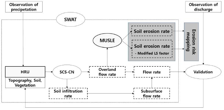
본 연구와 Kim et al. (2021c)의 차이점은 연구대상지, 입력자료 및 HRU 설정 등이 다르고, 유출량 모의 결과의 비교에 초점을 맞추고 침식량 계산은 수행하지 않았다. 하지만 Kim et al. (2021b)하고는 연구대상지, 입력자료 및 HRU 설정 등 모의 과정이 같지만 연구결과를 토양 붕괴(산사태)에 초점을 맞추어 결과 및 토론을 제안하였다. 본 연구에서는 Kim et al. (2012b)와 동일한 모의 과정을 거처 얻은 침식량에 대해 기술을 하고자 한다. 이에 본 연구는 그림 1에서 도시한바와 같이 지리산 국립공원내 유역을 대상으로 1) SWAT 모형의 유량 및 유사예측 정확성을 평가하고, 2) MUSLE를 이용한 표토침식 위험도 분석 및 3) 사면을 HRU로 세분화하여 표토침식 위험성을 분석한다. 그리고 기존 유역별 잠재적 표토침식 위험지역에서 사면별 잠재적 표토침식 위험지역을 규명하여 표토유실 관리 방안 및 대책안을 효율적으로 도출하고 이를 의사결정 자료로 활용하고자 한다.
2. 연구방법
2.1 연구지역
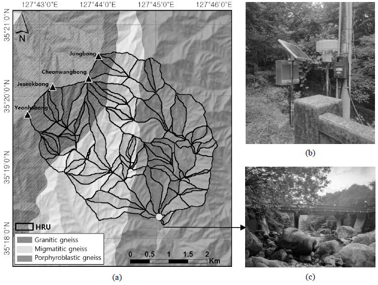
연구지역은 경상남도 산청군 시천면 중산리에 위치한 지리산 국립공원내 유역으로 경도 127°42′40″∼ 127°46′00′′, 북위 35°18′00′′∼ 35°21′00′′에 위치해있다(그림 2). 연구지역의 상부로는 연하봉(1,723 m), 제석봉(1,808 m), 천왕봉(1,915 m), 중봉(1,874 m)이 위치해 있고, 남쪽으로는 법계교가 위치해 있으며, 물은 법계교에서 남강의 지류인 시천천과 합류한다. 연구지역의 임상은 대부분 활엽수림이고, 유역내 북쪽 고지대는 침엽수림과 혼효림으로 이루어져있다(Forest Geospatial Information Services). 지질은 시대미상의 화강편마암으로 구성되어있다(data.kigam.re.kr) 기반암을 덮고 있는 토양은 자갈이 있는 사양토로 구성되어있고, 송산통에 속한다(Korean Soil Information System). 유역의 최종 유출 지점은 법계교(위도: 35°18′20.33′′, 경도: 127°44′53.55′′)로 설정하였고(그림 2a), 유량측정을 위해 법계교에 유량계를 설치하였다. 연구지역의 유역 면적은 약 6.9 km2로, 유역을 136개의 수문반응단위(Hydrologic Response Unit, HRU)로 분할하였다. 연구지역이 속한 산청군의 강우는 7월~8월에 집중되었으며, 연평균 걍수량은 1556.2 m로 기록되었다(Kim et al., 2021b, 2021c).
2.2 모형
SWAT은 장기 강우-유출 모형으로 유역내 토양특성 및 경작형태에 따른 물과 유사 그리고 농업화학물질의 거동 예측을 할 수 있다(Arnold et al., 1998). 또한 수문반응단위(HUR)별 강수, 지표 및 기저유출, 증발산, 토양수, 지하수 등에 대한 모의가 가능하며, 토양유실량 및 영양물질 저감 효율 평가가 가능하다(Neitsch et al., 2002). SWAT 모형에서 사용하는 방정식은 식 1과 같다.
| (1) |
SWAT에서 지표유출량은 SCS curve number (SCS-CN) 방법으로 계산하였다(식2, 3). SCS-CN (Soil Conservation Service, 1972) 방법은 미국 전역을 대상으로 20년 이상 농경지 소유역의 강우-유출 관계를 나타내는 경험식으로 다양한 토지이용 및 토양에서 유출량을 추정하기 위한 기준을 제공하기 위해 개발되었다(Rallison and Miller, 1982).
| (2) |
| (3) |
단일 강우에 의한 토양유실량 평가는 SWAT 모형에서 MUSLE로 산정하였다. MUSLE는 단일 강우사상에 대한 유출량 자료를 이용하여 개발된 식으로써, USLE의 강우에너지 인자가 총 유출량과 첨두유출량의 함수로 대체되어 MUSLE의 식 4와 같다(Williams, 1975). 또한 USLE는 농경지를 대상으로 하고 있어 산림지역 등 다양한 지역에 적용하기에는 한계를 지니고 있어(Jung et al., 2014), 아래 MUSLE 식 4에 산지의 지형을 고려한 LS 인자를 수정하여 MUSLE 식 5를 도출하였다. 식 4와 식 5의 첨두유출율과 식생피복인자는 각각 식 6과 식 7과 같다.
| (4) |
| (5) |
| (6) |
| (7) |
2.3 입력자료
SWAT 모형을 이용한 수문반응단위(HRU)의 표토침식 위험성을 분석하기 위해서는 시간적으로 변하는 기상자료와 유량자료가 필요하고, 공간적으로 변하는 지형, 식생 및 토양 자료 등이 필요하다. 입력자료는 국내 공공기관에서 제공하는 자료와 문헌자료를 참고하였다(표 1).
SWAT 모의에 사용한 기상자료는 2가지 형태로 구축하였다. 먼저, 기상청에서 2012년부터 2020년까지 관측한 자료를 이용하였으며, SWAT의 입력자료 형태에 맞게 지리산(872), 산청(289), 함양군(264) 관측소에서 일 강수량(nm), 일 최고/최저 기온(℃), 일 평균상대습도(%), 일 평균풍속(m/sec), 일 수평면 일사량(MJ/m2) 자료를 이용하였다. 두 번째로, SCS-CN 방법에서 강우량은 일 단위로 계산된다. 이는 강우사상의 강도와 지속시간이 왜곡될 수 있고, 지표 유출량을 과소 모의(King et al., 1999; Jeong et al., 2010) 할 수 있다. 그러므로 본 연구에서는 이러한 한계를 개선하고 강우의 시간적 연속성을 반영하기 위해 SCS-CN의 일강우량 (Rday)을 해당 일에 종료된 강우사상 강우량의 총합으로 정의하였다(Kim et al., 2021a). 이 때 강우량이 1시간 동안 0.1mm 이상 기록되지 않으면 새로운 강우사상으로 구분하였다(Kim et al., 2021a).
SWAT 모의 결과의 성능을 분석하기 위해 법계교에 설치한 유량관측소의 일일 평균 유량 자료를 사용하였고 실측 기간은 2018.10.01.~2020.12.30.에 해당한다. 유량은 관측소에서 측정되는 수위는 유속과의 관계를 통해 일평균 유량으로 변환하여 유량-수위 관계 곡선식을 만들었다(Kim et al., 2021b). 자료의 수집 한계로 유속부분은 이 곡선식과의 환산을 통해 분석하였다.
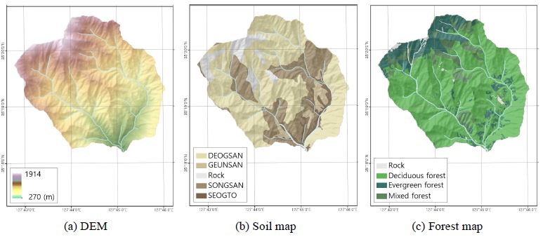
지형자료는 국토지리정보원(National Geographic Information Institute, NGII)에서 제공하는 1:5,000 수치지형도에서 등고선과 표고점을 추출하여 ArcGIS 10.5를 이용하여 10 m 해상도(Columns 497, Rows 449)를 가지는 DEM을 생성하였다(그림 3a). 그리고 생성된 DEM에 하천중심선을 ArcSWAT으로 Burn-in하여 연구지역을 소유역으로 분할하였다(Kim et al., 2021b). 그리고 산림청(Korea Forest Service, KFS)에서 제공하는 1:5,000 산림입지 토양도(그림 3b)를 기반으로 국립농업과학원(National Institute of Agricultural Science, NIGS) 흙토람(Korean Soil Information System)과 한국건설기술연구원(Korea Institute of Construction Technology (KICT), 2007)에서 제공하는 매개변수 값을 입력하여 구축하였다. 토지이용자료는 산림청에서 제공하는 1:5,000 임상도(그림 3c)를 기반으로 SWAT 모형의 입력자료를 구축하였다(Kim et al., 2021b, 2021c).
2.4 유량검증
SWAT 모형을 이용한 모의유량에 대한 정확성을 평가하기 위해 법계교에서 실측한 유량자료를 이용하여 결정계수(Coefficient of Determination, R2)와 모형효율계수(Nash-Sutcliffe Efficiency, NSE)로 검증하였다(식 8, 9). R2는 NSE 모의와 실측값의 상관관계가 높아질수록 1에 가까워지고, NSE는 모의와 실측값이 일치할수록 1에 가까워진다. 각각의 값은 다음과 같이 계산된다(Kim et al., 2021b).
| (8) |
| (9) |
여기서 Oi는 개별 실측값이고, 는 실측된 모든 값의 평균이다. Pi는 개별 모의값이고, 는 모의된 모든 값의 평균이다.
3. 결 과
3.1 유량
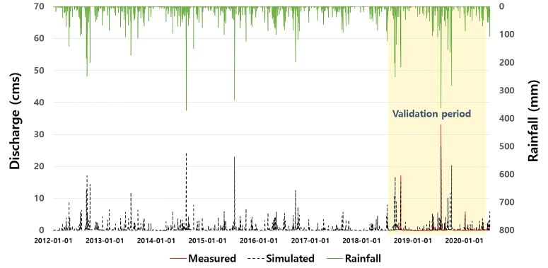
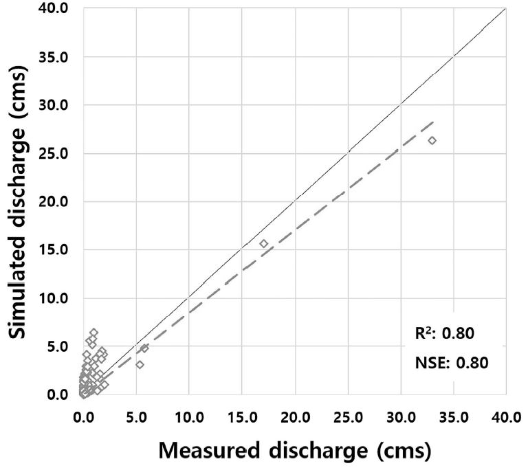
본 연구에서는 2010~2011년까지의 기간을 SWAT 모형의 초기반응계수 안정화 기간(Warm-up Period)으로 설정하였다. 매개변수 추정을 수행한 기간은 2012.01.01.~2020.12.30.로 설정하였고, SWAT의 일단위 모의 유출량에 대한 검증자료는 2019.1.1.~2020.12.30. 기간 동안 법계교에서 실측한 유량자료를 사용하였다. 그리고 검증된 매개변수 기준으로 2012년부터 2020년 까지 재해석을 하였다. 그림 4는 모의 및 검증 기간 동안 실제 관측된 일일 강우량과 일일 평균 유량을 시계열적으로 보여준다. 이 중 일일 평균 유량이 초당 200 m3가 넘는 사상은 2009, 2014, 2015, 2018년에 각각 1번, 2019년에 2번 총 6번 나타났다. 보정된 모의 유출량과 실측한 유출량 간의 정확성 평가를 수행한 결과, 실측값(X축)과 모의값(Y축)에 대한 R2와 NSE는 각각 0.8과 0.8로 분석되었다(그림 5). Moriasi et al. (2015)의 기준에 따르면 본 연구에서 SWAT의 유량 모의에 있어 보정기간 동안은 좋은 성능(0.75<R2<0.85; 0.70< NSE<0.80)을 보였다.
3.2 표토침식 위험도
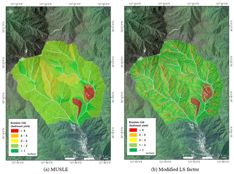
SWAT 모형의 토양유실량 산정을 위해 USLE에서 강우인자를 수정한 MUSLE 식 4와 여기에 지형인자를 추가로 수정한 MUSLE 식 5를 이용하여 135개의 HRU에 대한 토양유실량을 계산 후 공간적 분포를 확인하였다. 강우인자와 지형인자를 수정 반영한 그림 6a와 6b는 토양유실량을 표토침식 위험도로 표현한 그림이다. 토양유실이 가장 적은 곳은 0, 가장 많은 곳은 5 이상으로 표현하였다. 그림 6a, 6b에서 토양유실량이 많이 발생하는 곳은 토양도에서 근산통과 석고통에 위치한다. 그림 6a는 산지지형의 고려 없이 강우인자만 고려하였을 때, 토양유실량 분포도는 HRU 단위로 범주형으로 나타났다. 하지만 그림 6b는 산지지형의 조건을 추가로 고려하였을 때 그림 6a에 비하여 시각적으로 공간적 해상도가 높게 나타남을 확인할 수 있었다.
4. 결론 및 토론
본 연구에서는 유역을 136개의 HRU로 세분화고, USLE의 강우인자만 수정하였을 경우의 MUSLE 표토침식 위험도는 HRU 단위별로 범주형으로 표현되었다. HRU 1개에도 다양한 정보들이 있지만 정보들이 HRU 크기에 반영되지 않았다. 하지만 USLE의 강우인자와 지형인자를 모두 수정하였을 경우, 표토침식 위험도에는 사면지형이 반영되어 전자보다 공간해상도가 높게 나타났다. 공간해상도면에서 일반적으로 소유역에서는 사면이 세 개 이내로 나누어진다. 이 하나의 사면은 더 세분화 할 수 있지만 실질적인 사면을 반영하기 위해서는 어느 정도의 HRU로 세분화해야 하는지는 연구가 필요할 것으로 판단된다.
본 연구에서 모의유량의 검증은 실측 유량값을 사용하였지만, 토양유실량의 검증은 실측 자료가 없기 때문에 이루어지지 않았다. 그러므로 본 연구의 토양유실량 기반의 표토침식 위험도는 정량적인 해석보다는 각 HRU 간의 비교로 해석할 수 있다. 그래서 향후 연구에서는 각 사면별로 플롯실험을 통해 침식에 대한 정량적인 평가가 필요할 것으로 판단된다. 예를 들면 사면 단위로 HRU를 설정하여 추후 플롯실험을 통해 얻을 수 있는 침식량 실측 자료와 비교하거나, 또한 위 방법을 사용했을 시 부족한 공간적 해상도를 해결하기 위해 지형인자 식을 수정하는 연구가 필요할 것으로 판단된다. 향후 이러한 연구 결과들은 정량적으로 토양유실량을 계산할 수 있고, 그 결과 잠재적 표토침식 위험도를 공간적으로 파악함으로써 토양유실 방지 및 사면안전 계획을 수립하기에 기조차료로 활용할 수 있을 것이다.
Acknowledgments
본 연구는 환경부 환경산업기술원의 표토보전관리기술개발사업(과제번호: 2019002830003)과 산림청 한국임업진흥원 산림분야 재난·재해의 현안해결형 연구개발사업(과제번호: 2021342A00-2123-CD01)의 지원에 의하여 수행되었다.
References
-
Arnold, J.G., Srinivasan, R., Muttiah, R.S. and Williams, J.R., 1998, Large Area Hydrologic Modeling and Assessment Part I: Model Development. Journal of the American Water Resources Association, 34, 73-89.
[https://doi.org/10.1111/j.1752-1688.1998.tb05961.x]

- Bae, Y.J., Lee, H.J., Jung, B.W. and Jung, H., 2020, Korean Climate Change Assessment Report. Korea Meteorological Administration, Seoul, 4-7.
-
Benavidez, R., Jackson, B., Maxwell, D. and Norton, K., 2018, A Review of the (Revised) Universal Soil Loss Equation ((R)USLE): With a View to Increasing Its Global Applicability and Improving Soil Loss Estimates. Hydrology and Earth System Sciences, 22, 6059-6086.
[https://doi.org/10.5194/hess-22-6059-2018]

-
Bieger, K., Hormann, G. and Fohrer, N., 2015, Detailed spatial analysis of SWAT-simulated surface runoff and sediment yield in a mountainous watershed in China. Hydrological Sciences Journal, 60, 784-800.
[https://doi.org/10.1080/02626667.2014.965172]

-
Chiang, L.C., Liao, C.J., Lu, C.M. and Wang, Y.C., 2021, Applicability of modified SWAT model (SWAT-Twn) on simulation of watershed sediment yields under different land use/cover scenarios in Taiwan. Environmental Monitoring and Assessment, 193, 520.
[https://doi.org/10.1007/s10661-021-09283-9]

-
Choi, C.H., You, J.H. and Jung, S.G., 2013, Estimation of Danger Zone by Soil Erosion Using RUSLE Model in Gyeongju National Park. Korean Journal of Environment and Ecology, 27, 614-624.
[https://doi.org/10.13047/KJEE.2013.27.5.614]

-
Gwapedza, D., Nyamela, N., Hughes, D.A., Slaughter, A.R., Mantel, S.K. and van der Waal, B., 2021, Prediction of sediment yield of the Inxu River catchment (South Africa) using the MUSLE. International Soil and Water Conservation Research, 9, 37-48.
[https://doi.org/10.1016/j.iswcr.2020.10.003]

-
Jeong, J., Kannan, N., Arnold, J., Glick, R., Gosselink, L. and Srinivasan, R., 2010, Development and Integration of Sub-hourly Rainfall-Runoff Modeling Capability Within a Watershed Model. Water Resources Management, 24, 4505-4527.
[https://doi.org/10.1007/s11269-010-9670-4]

-
Ji, U., Hwang, M.H., Yeo, W.K. and Lim, K.S., 2012, Risk Assessment and Potentiality Analysis of Soil Loss at the Nakdong River Watershed Using the Land Use Map, Revised Universal Soil Loss Equation, and Landslide Risk Map. Journal of Korea Water Resources Association, 45, 617-629 (in Korean with English abstract).
[https://doi.org/10.3741/JKWRA.2012.45.6.617]

-
Jung, Y., Lee, S., Lee K., Park, K. and Lee, H., 2014, Application of RUSLE and MUSLE for Prediction of Soil Loss in Small Mountainous Basin. Journal of Korean Forest Society, 1, 98-104.
[https://doi.org/10.14578/jkfs.2014.103.1.98]

- Kim, E.S., Lee, H.Y., Yang, J.,E., Lim, K.J. and Park, Y.S., 2020a, Monthly Sediment Yield Estimation Based on Watershed-scale Application of ArcSATEEC with Correction Factor. Journal of Soil and Groundwater Environment, 25, 52-64.
- Kim, J., Kim, M. and Cho, Y., 2021a, Assessment of Relationship between Sediment-Discharge Based on Rainfall Characteristic using SWAT Model. Journal of Soil and Groundwater Environment, 26, 118-129 (in Korean with English abstract).
- Kim, J., Kim, M., Cho, Y., Oh, H. and Lee, C., 2021b, Suggestion and Evaluation for Prediction Method of Landslide Occurrence using SWAT Model and Climate Change Data: Case Study of Jungsan-ri Region in Mt. Jiri National Park. Journal of Soil and Groundwater Environment, 26, 106-117 (in Korean with English abstract).
-
Kim, J., Kim, M., Kim, J., Oh, H.-J. and Woo, C., 2021c, Analysis of Rainfall-Runoff Characteristic at Mountainous Watershed using GeoWepp and SWAT Model. Journal of the Korean Geomorphological Association, 28, 31-44 (in Korean with English abstract).
[https://doi.org/10.16968/JKGA.28.2.31]

- Kim, S., Lee, D., Jung, S. and Lee, G., 2020b, Assessment of Soil Erosion and Sedimentation in Cheoncheon Basin Considering Hourly Rainfall. Journal of the Korean GEO-Environmental Society, 21, 5-17 (in Korean with English abstract).
- Kim, S., You, C., Lee, S.-W., Ji, W.-H. and Jang, M.-W., 2017, Development of USLExls and its Application for the Analysis of the Impact of Soil-Filling Work on Soil Loss. Journal of the Korean Society of Agricultural Engineers, 59, 109-125 (in Korean with English abstract).
-
King, K., Arnold, J. and Bingner, R., 1999, Comparison of Green-Ampt and Curve Number Methods on Goodwin Creek Watershed Using SWAT. Transactions of the ASAE. Transactions of the American Society of Agricultural Engineers, 42, 919-926.
[https://doi.org/10.13031/2013.13272]

-
Koo, J.-Y., Yoon, D.-S., Lee, D.J., Han, J.H., Jung, Y., Yang, J.E. and Lim, K.J., 2016, Effect of DEM Resolution in USLE LS Factor. Journal Korean Society on Water Environment, 32, 89-97 (in Korean with English abstract).
[https://doi.org/10.15681/KSWE.2016.32.1.89]

- Korea Institute of Construction Technology (KICT), 2007, 21st Century Frontier R&D Program-Sustainable Water Resources Research Program: Development of Integrated Framework for Water Resources Management. Ministry of Science and ICT, 136 p (in Korean).
- Korean Soil Information System, 2022, https://soil.rda.go.kr, (May 30, 2022).
-
Lee, D.J., Lee, J.M., Kum, D., Park, Y.S., Jung, Y., Shin., Y, Jeong, G.-C., Lee, B.C. and Lim, K.J., 2014, Analysis of Effects on Soil Erosion Reduction of Various Best Management Practices at Watershed Scale. Korean Society on Water Environment, 30, 638-646.
[https://doi.org/10.15681/KSWE.2014.30.6.638]

- Lee, S., Lee, G., Yang, D., Choi, Y., Lim, K.J. and Jang, W.S., 2019, Occurrence and Behavior Analysis of Soil Erosion by Applying Coefficient and Exponent of MUSLE Runoff Factor Depending on Land Use. Journal of Wetlands Research, 21, 98-106 (in Korean with English abstract).
-
Moriasi, D.N., Gitau, M.W., Pai, N. and Daggupati, P., 2015, Hydrologic and water quality models: Performance measures and evaluation criteria. Transactions of the ASABE, 58, 1763-1785.
[https://doi.org/10.13031/trans.58.10715]

- Neitsch, S.L., Arnold, J.G., Kiniry, J.R., Williams, J.R. and King, K.W., 2002, Soil and water assessment tool theoretical documentation version 2000. Grassland, Soil and Water Research Laboratory, Agriculture Research Service, Blackland Research Center, Texas Agricultural Experiment Station.
- Rallison, R.E. and Miller, N., 1982, Past, Present, and Future SCS Runoff Procedure. In Rainfall-Runoff Relationship, International Symposium on Rainfall-Runoff Modeling, Littleton, Co, USA, 353-364.
-
Sadeghi, S.H.R., Gholami, L., Khaledi Darvishan, A. and Saeidi, P., 2014, A review of the application of the MUSLE model worldwide. Hydrological Sciences Journal, 59, 365-375 (in Korean with English abstract).
[https://doi.org/10.1080/02626667.2013.866239]

- Sim, K.-W. and Lee, J.-H., 2010, A Causality Analysis on the Relationship Between National Park Visitor Use and Economic Variables. Journal of Korean Society of Forest Science, 99, 573-579.
- Soil Conservation Service, 1972, National engineering handbook, section 4: Hydrology. Washington (DC), US Department of Agriculture.
-
Tomoyasu, S., Katsuya, O., Hisashi, M., Tatsuo, N. and Masahiko, S., 1995, Statistical rainfall risk estimating method for a deep collapse of a cut slope. Soils and Foundations, 35, 37-48.
[https://doi.org/10.3208/sandf.35.4_37]

-
Wei, W., Chen, L., Fu, B., Huang, Z., Wu, D. and Gui, L., 2007, The effect of land uses and rainfall regimes on runoff and soil erosion in the semi-arid loess hilly area, China. Journal of Hydrology, 335, 247-258.
[https://doi.org/10.1016/j.jhydrol.2006.11.016]

- Williams, J.R., 1975, Sediment-yield prediction with universal equation using runoff energy factor: Present and prospective technology for predicting sediment yield and sources, 244-252.
-
Yu, N.Y., Lee, D.J., Han, J.H., Lim, K.J., Kim, J., Kim, K.H., Kim, S., Kim, E.S. and Park, Y.S., 2017, Development of ArcGIS-based Model to Estimate Monthly Potential Soil Loss. Journal of the Korean Society of Agricultural Engineers, 59, 21-30 (in Korean with English abstract).
[https://doi.org/10.5389/KSAE.2017.59.1.021]

-
Zhang, G.H., Nearing, M.A. and Liu, B.Y., 2005, Potential effects of climate change on rainfall erosivity in the Yellow River basin of China. Transactions of the ASAE, 48, 511-517.
[https://doi.org/10.13031/2013.18325]

-
Zhang, Y.Y., Xia, J., Chen, J.F. and Zhang, M.H., 2011, Water quantity and quality optimization modeling of dams operation based on SWAT in Wenyu River Catchment, China. Environmental Monitoring and Assessment, 173, 409-430.
[https://doi.org/10.1007/s10661-010-1396-5]


