포항 북부 유계-중산리에서 확인되는 양산단층의 제4기 단층운동 특성
 ; Jongwon Han1 ; Sangmin Ha1 ; Haewon Lim1 ; Yeong Bae Seong2
; Jeong-Heon Choi3
; Cho Hee Lee2 ; Seok-Jin Kim3 ; Hee-Cheol Kang1
; Min-Cheol Kim1 ; Hyunjee Lim1
; Moon Son1, ‡
; Jongwon Han1 ; Sangmin Ha1 ; Haewon Lim1 ; Yeong Bae Seong2
; Jeong-Heon Choi3
; Cho Hee Lee2 ; Seok-Jin Kim3 ; Hee-Cheol Kang1
; Min-Cheol Kim1 ; Hyunjee Lim1
; Moon Son1, ‡
초록
기존에 제4기 단층으로 보고된 유계지점에서부터 송라면 중산리까지 1954년 항공사진과 고해상도 LiDAR 영상을 활용한 상세 지형분석, 지질조사, 지구물리탐사, 굴착조사 및 연대측정를 수행하였다. 이를 통해 북부 양산단층의 제4기 단층운동 시기와 특성을 분석하고자 하였다. 선형구조 분석결과, 북북동 방향으로 연장되어 보경사지점을 지나가는 길이 6.8 km의 선형구조 1매와 유계지점을 지나가는 길이 0.35 km의 선형구조 1매가 확인하였으며, 두 선형구조는 굴절하천과 단층와지의 선형적인 분포 패턴과 뚜렷한 선형곡에 의해 인지되었다. 굴절하천의 굴절량은 서정천, 청하천, 광천에서 각각 2.05 또는 2.82 km, 1.72와 0.74 km 그리고 0.43 km로 북쪽으로 갈수록 점차 감소하는 양상이다. 이중 제4기 퇴적층이 발달하고 인위적인 개발이 거의 없는 광천을 대상으로 집중적으로 상세 지질조사와 전기비저항탐사를 수행하였고, 이를 통해 각 1개의 노두지점과 굴착지점에서 제4기 미고결 퇴적층을 절단하는 단층을 확인하였다. 제4기 퇴적층과 접하는 단층면에는 역이동 성분을 포함하는 우수향 주향이동 운동을 지시하는 단층조선이 발달하고 제4기 퇴적층과 인접한 단층핵에는 제4기 퇴적층의 역들이 단층비지와 혼합된 특징을 보인다. 제4기 퇴적층과 단층의 절단 관계 그리고 절단된 퇴적층과 단층을 피복하는 퇴적층에서 얻은 퇴적층의 루미네센스 연대를 종합하면, 이곳 단층의 최후기 운동은 154±13 ka와 0.9±0.1 ka 사이에 발생하였으며, 제4기 동안 최소 2회 이상의 단층 운동이 발생한 것으로 해석된다. 노두에서 확인되는 실변위량 그리고 절단된 퇴적층과 피복하는 퇴적층의 연대 시간차를 이용해 계산된 변위율은 0.007~0.008 mm/yr로 계산되었다. 기존에 보고된 유계지점의 수직변위율을 단층자세와 단층조선을 통해 실변위율로 환산하면 0.08 mm/yr이다. 두 결과를 종합하여 얻은 연구지역 양산단층의 변위율은 0.007~0.08 mm/yr 범위를 가질 것으로 추정된다. 노두에서 확인되는 실변위량을 한 번의 지표파열의 변위로 가정하고 최대변위-모멘트 지진규모 경험식에 적용하면 지진규모는 약 6.7로 계산되고, 선형구조의 길이를 지표파열 길이로 가정하여 파열길이-모멘트 지진규모 경험식에 적용하면 약 6.0의 규모가 도출된다.
Abstract
In this study, we conducted a geomorphologic analysis, fieldwork, geophysical survey, and trench survey to trace the Quaternary faulting along the northern Yangsan fault. We also complement the study with the Electron Spin Resonance and luminescence datings of the fault rocks and Quaternary sediments, respectively, to constrain the timing of the Quaternary faulting. As a result of geomorphological analysis, two lineaments with lengths 6.8 km and 0.35 km are recognized by the linear distribution pattern of fault saddles and deflected streams. The amount of deflection of deflected streams is 2.05-2.82 km, 1.72 and 0.74 km, and 0.43 km in Seojeongcheon, Cheonghacheon, and Gwangcheon stream, respectively, which decreases gradually toward the north. Faults cutting the unconsolidated sediments were found at an outcrop and trench site, and both the sites have the following similar features: slickenlines on the fault surface in contact with the Quaternary sediments, indicating a dextral strike-slip including a reverse component, and a mixed zone of Quaternary sediment and fault gouge between the fault core and the Quaternary sediment. Their cross-cutting relationship indicates at least two faulting events during the Quaternary. Luminescence ages obtained from the sediment layers indicate that the latest faulting event occurred between 154±13 ka and 0.9±0.1 ka. The slip rate, calculated by dividing the net displacement by the age gap, is 0.007 to 0.008 mm/yr. Also, the conversion of the vertical displacement of the Yugye site reported in the previous study into the net displacement gives rise to an estimated slip rate of about 0.08 mm/yr. Combining the results, the slip rate of the northern Yangsan fault in the study area is estimated to be in the range of 0.007 to 0.08 mm/yr. The moment magnitude (Mw) obtained using the net displacement in the empirical equation is about 6.7, and the magnitude of about 6.0 is derived using the lineament length as the surface rupture length.
Keywords:
Yangsan fault, the Quaternary fault, active fault, slip-rate, moment magnitude키워드:
양산단층, 제4기 단층, 활성단층, 변위율, 지진규모1. 서 언
지진은 21세기 들어 가장 많은 희생자를 낸 자연재해 중 하나이다. 2004년 12월 26일에는 쓰나미(지진해일)의 강타로 인도네시아 등 인도양 연안 14개 국가에서 35만여 명이 죽거나 실종됐다. 또한 2005년 10월 8일 규모 7.6의 파키스탄 지진으로 약 75,000명, 2008년 5월 12일 규모 7.9의 쓰촨성 지진으로 약 87,000명, 2010년 1월 규모 7.0의 아이티 지진으로 약 160,000명, 2011년 규모 9.0의 동일본 대지진 때는 약 18,400명이 희생되었다. 이처럼 지진은 지진동과 지표파열에 의한 구조물 파괴, 지반 붕괴 등을 일으킬 뿐만 아니라 지진해일, 화재, 액상화 등으로 인해 더 큰 2차 피해를 유발할 수 있다.
유라시아판 동편 가장자리에 위치하는 한반도(그림 1a)는 대규모 지진이 빈번히 발생하는 판 경계 지역과는 달리 지진 발생 가능성이 적은 것으로 인식되어 왔다. 그러나 과거 역사 문헌에는 성곽이 무너지고 100명 이상의 인명피해를 일으킨 파괴적인 지진이 발생한 기록이 존재한다(Lee, 1998, 2010; Lee and Yang, 2006). 또한 최근 지진의 발생빈도가 증가하고 있으며, 경주지진(2016년 9월 12일, Mw 5.5), 포항지진(2017년 11월 15일, Mw 5.4)이 연이어 발생하면서 영남권에는 강한 지진동으로 인해 많은 사회적·경제적 피해가 발생하였다. 이로 인해 한반도는 지진의 안전지대가 아니라는 불안감과 함께 지진재해 대비를 위한 활성단층 연구의 필요성이 부각되었다.

(a) Present-day tectonic map in the vicinity of East Asia showing several plates and their moving velocities (modified from Schellart and Rawlinson, 2010). The velocities of the plates are based on the Indo-Atlantic hotspot reference frame (O’Neill et al., 2005) and the relative plate motion model (DeMets et al., 1994). (b) Simplified geological map (modified from Hwang et al., 1996; Kim et al., 1998; Choi et al., 2002) of the Gyeongsang Basin and Miocene basins. Stratigraphic correlation of the Gyeongsang basin-fills is reconstructed from Chang et al. (2003), Chough and Sohn (2010), and Kang and Paik (2013). Distribution of Miocene basin-fills and faults are modified after Son et al. (2013, 2015). (c) Distribution map of major faults and observed locations of Quaternary fault outcrops in SE Korea. Black arrows indicate geometrically defined fault zone segmentation (Choi et al., 2017).
우리나라의 활성단층 연구는 1990년대 초부터 본격화되었으며, 주로 원자력산업과 관련된 시설물의 지진학적 안정성을 평가·확보하기 위한 목적이었다. 따라서 원자력 발전소가 주로 위치하는 한반도 남동부 지역을 중심으로 진행되었으며, 그 결과 지난 30여 년간 양산단층, 울산단층, 연일구조선 등을 따라 약 60여 개의 지점에서 제4기 퇴적층을 변위시킨 단층 지점들이 보고된 바 있다(그림 1c; Okada et al., 1994; Ryoo et al., 1996, 1999, 2001, 2002, 2006; Kyung, 1997, 2003; Chwae et al., 1998; Kyung et al., 1999a, 1999b; Lee, B.J. et al., 1999; Chang, 2001; Kyung and Chang, 2001; Choi, W.-H., 2003; Im et al., 2003; Lee, 2003; Kim, Y.-S. et al., 2004, 2011b; Choi, P., 2005; Kim and Jin, 2006; Kee et al., 2007; Kang and Ryoo, 2009; Ryoo, 2009; Choi et al., 2012; Jin et al., 2013; Lee, J. et al., 2015; Kim, M.-C. et al., 2016; Lee, Y. et al., 2017; Cheon et al., 2020; Song et al., 2020; Gwon et al., 2021). 하지만 기존 연구들은 대부분 개별 지점에서의 조사가 이루어져 단층의 연장과 관련한 분절 특성, 고지진의 시공간적 이력 등에 대한 실질적이고 거시적인 관점의 연구는 미흡하였다. Kim et al. (2011a)과 Choi et al. (2017)는 이러한 문제를 해결하기 위해서 고해상도 위성영상과 LiDAR (Light Detection and Ranging)기법 등을 활용하여 지형학적 분석에 기초한 활성단층의 추적이 필요함을 주장하였다.
이번 연구는 포항시 청하면 유계리에서 송라면 중산리 일원의 양산단층을 따라 LiDAR 영상과 1954년에 촬영된 항공사진을 이용한 지형학적 분석을 통해 단층의 자취를 먼저 추적하였으며, 지형학적 증거를 바탕으로 분석된 선형구조와 야외 지질조사 및 지구물리탐사 결과를 이용해 굴착지점을 선정하였다. 제4기 단층이 발견된 지점에서는 상세한 구조분석과 제4기 퇴적층의 루미네선스(luminescence) 연대측정과 단층암에 대해 전자스핀공명(ESR; Electron Spin Resonance) 연대측정을 통해 운동시기와 변위률을 밝히고자 하였다. 또한 지진 규모를 산정하기 위하여 단층조선의 운동감각으로부터 구한 단층운동의 실변위량 그리고 지형분석을 통해 추정된 지표파열 길이와 지진규모와의 경험식을 이용하였다.
2. 지질학적 배경
한반도는 현재 유라시아판 또는 아무르판 내부에 위치하며, 태평양판, 필리핀해판 등의 대규모 판과 오키나와판, 오호츠크판, 양쯔판 등의 소규모 판들과 인접해 위치한다(그림 1a). 한반도에는 인접한 태평양판의 저각 섭입과 인도-유라시아판의 충돌에 의한 영향으로 동-서 내지 동북동-서남서 방향의 최대수평응력이 작용하고 있는 것으로 알려져 있다(e.g., Park et al., 2006; Kim et al., 2016).
한반도 남동부에는 백악기 경상분지 퇴적암류와 화성암류가 넓게 분포하고 동해 확장과 관련한 마이오세 분지의 충전물이 동해안가를 따라 분포한다(그림 1b). 또한 백악기-신생대 동안 활발한 지각변형으로 양산단층계, 가음단층계, 연일구조선 그리고 마이오세 분지들의 경계단층들이 발달하고 있다(그림 1c). 이 중 규모가 가장 큰 양산단층계는 자인, 밀양, 모량, 양산, 동래, 일광단층으로 구성되며, 이들은 경상분지 퇴적암류와 백악기-고신생기 화성암류를 절단한다. 양산단층은 양산단층계를 구성하는 단층들 중 연장이 가장 길고 단층대의 폭이 넓은 단층으로 육상에서 이 단층을 따라 확인되는 선형구조의 길이만 170 km 이상으로, 최대 수 km 폭의 단층대와 20~35 km의 우수향 수평변위가 인지된다(e.g., Reedman and Um, 1975; Choi et al., 1980; Um et al., 1983; Chang et al., 1990; Hwang et al., 2004, 2007a, 2007b). 한편 기존 연구들은 양산단층계가 백악기 이래로 유라시아판 아래로 섭입하는 고태평양판(이자나기 또는 쿨라판)과 이후의 태평양판 및 필리핀해판의 영향에 의해 다중변형을 겪었음을 보고하고 있다(Cheon et al., 2017, 2019).
Chang (2002)은 양산단층대를 따라 발달하는 선형구조 방향의 변화, 단층대 폭의 변화, 단층 말단부의 발달형태, 주단층과 부차단층 간의 관계에 근거해 양산시에서 포항시 신광면 사이 약 110 km 구간을 약 20~30 km의 길이를 가지는 5개의 분절로 구분하였다. 한편, Lee and Jin (1991)은 역사와 계기 지진자료를 바탕으로 양산단층을 3조의 분절로 구분하였으며, 최근 Choi et al. (2017)은 지진학, 구조지질학, 고지진학적 자료와 위성영상에서 인지되는 기하학적 특성을 바탕으로 양산단층이 크게는 3조의 분절(북부, 중부, 남부)과 9개의 세부 분절로 구분하였다. 이번 연구지역은 Choi et al. (2017)이 제안한 분절 중 북부 분절의 남부에 해당한다.
연구지역인 포항시 청하면 유계리에서 송라면 중산리 일원은 양산단층이 서편의 백악기 화산암류와 동편의 퇴적암류를 경계하며 절단하고 있다(그림 2). 이곳 양산단층은 남쪽에서 북쪽으로 가면서 우향 굴곡(right bending)되고 두 개의 단층으로 분지되다 다시 합류되어 북북동 방향으로 연장되는 양상이다. 양산단층 동편에는 마이오세 포항분지 서쪽 경계단층이 충전물인 연일층군 퇴적암의 분포를 규제하고 있으며, 이 경계단층은 북북동 방향의 정단층과 북서 방향의 이음단층(transfer fault)이 지그재그 형태로 이어지는 기하를 보인다(Son et al., 2013).

Detailed Geological map of the study area showing the distribution of the Yangsan fault and observed localities of the Quaternary fault (modified after Chang et al., 1990; Song, 2015).
한반도 남동부에는 제4기 이후 지표파열을 유발한 단층이 계속 발견되고 있으며, 역사기록과 지진관측에서도 이곳이 다른 지역에 비해 지진활성도가 높음을 보여준다(Kim et al., 2016; Cheon et al., 2020). 한반도 남동부에서 현재까지 발견된 제4기 단층들의 지점들은 대부분 양산단층, 연일구조선, 울산단층과 같은 기존 단층대를 따라 선상으로 배열된다(그림 1c). 이는 제4기 동안 단층운동이 새로이 만들어진 단층에서 발생했다기보다는 주로 기존 약대가 재활되며 발생하였음을 지시한다.
포항시 청하면~송라면 일원은 양산단층을 따라 체계적으로 굴절하도가 발달하며(Lee et al., 2019), 기존 연구에서 제4기 단층운동과 관련된 주요 노두로 보고된 반곡지점, 유계지점, 보경사지점이 위치한다(Kyung and Chang, 2001; Kyung, 2003; Choi et al., 2012; 그림 2). 반곡지점은 양산단층대의 주단층선과 인접한 절개사면으로 이곳 단층은 기존 단층핵이 미고결 제4기 퇴적층을 충상하는 기하를 보이며 단층면과 조선의 자세는 각각 N42°E/85°NW, 230°/25°로서 비지대의 ESR 연대는 640±60 ka로 보고되었다(Im et al., 2003). 유계지점의 단층의 자세는 남-북 내지 N10~13°E 주향에 약 45°로 동쪽으로 경사지며, 역이동성 우수향 주향이동 운동감각이 보고되었다(Kyung and Chang, 2001). 단층에 의해 절단된 미고결 역층 내 실트층은 약 26,000 yr BP 이후 약 1.4 m의 수직변위를 겪어 0.04~0.05 mm/yr의 수직변위율이 산정된 바 있다. 또한 14C 연대측정을 통해 최후기 단층 운동시기는 약 1,314 yr BP (AD 636) 이후로 해석되었다(Kyung, 2003). 한편, Choi et al. (2012)은 포항시 북구 송라면 보경사 정문 남쪽 하천(그림 2의 보경사지점)에서 N10°E/80° NW의 자세로 서편의 백악기 화산암류와 동편의 백악기 퇴적암을 경계하는 양산단층대 노두를 조사해 16.5±0.1 Ma의 단층암 Rb-Sr 연대를 보고하였다. 그러나 당시에는 이곳에서 단층이 미고결 퇴적층을 절단하고 있음을 관찰하지 못했다.
3. 지형분석 및 전기비저항탐사
3.1 지형분석 결과
연구지역 내의 제4기 단층 추적을 위해 고해상도 LiDAR (0.5 m 해상도)와 과거 항공사진(1954년)을 바탕으로 상세 지형분석을 실시하였다(그림 3). 연구지역의 서편에 내연산(711 m)과 천령산(774 m) 등 해발고도 700 m 이상의 산지가 분포하고 산지에서 발원한 서정천, 청하천, 광천은 모두 동해로 흘러가며, 이들 하천을 따라 양안에는 하안단구와 범람원이 발달한다. 선형구조 분석결과, 유계저수지 북단에서부터 북북동 방향으로 연장되어 보경사지점을 지나가는 길이 6.8 km의 선형구조 1매 그리고 이 선형구조로부터 남동쪽으로 0.8 km 떨어져 유계지점을 지나가는 길이 0.35 km의 선형구조 1매가 추출되었다. 두 선형구조는 굴절하천과 단층와지의 선형적인 분포 패턴과 뚜렷한 선형곡에 의해 인지되었으며, 안행상(en echelon)으로 발달한다.

(a) Lineaments and geomorphic features in LiDAR image of the study area (modified from Lee et al., 2019). Deflected patterns of (b) Kwangcheon stream, (c) Cheonghacheon stream, and (d) Seojeongcheon stream, which are interpreted from aerial photo taken in 1954. Each figure shows deflected stream, and dashed lines indicate the best fitting of each deflected stream.
북서-남동 방향으로 발달하는 세 하천, 서정천, 청하천, 광천은 서편 산지에서 발원하여 동쪽으로 흐르다가 양산단층과 평행한 선형구조 주변에서 유로가 급격히 모두 우향 굴곡된다(그림 3). 또한 이들 하천을 둘러싸고 있는 유역분지의 형태도 유사하게 우향으로 굴곡되고 있어, 연구지역 하천들이 우수향 수평이동 성분이 우세한 단층운동으로 인해 굴곡된, 즉 굴절하천(deflected stream)인 것으로 해석된다(Lee et al., 2019). 과거 항공사진을 이용해 하천의 굴절량을 구해보면, 서정천, 청하천, 광천에서 굴절량은 각각 2.05 또는 2.82 km, 1.72와 0.74 km 그리고 0.43 km로 북쪽으로 갈수록 점차 감소하는 양상이며, 광천 이북에는 굴절하천이 확인되지 않는다. 서정천의 큰 굴절량은 하천의 굴절과 함께 곡저분지가 급격히 넓어져 과거 빈번한 유로변경과 관련될 가능성이 있다(그림 3d). 한편, 청하천은 상류에 두 개의 지류가 하류에서 합쳐지는데, 두 지류의 굴절량은 각 1.72 km, 0.74 km로 차이를 보인다(그림 3c). 가장 북쪽의 광천은 가장 작은 굴절량인 0.43 km를 보인다(그림 3b). 서정천이 굴절되는 곳에는 유계저수지가 위치하고, 청하천의 굴절부는 하천 상류에 위치해 제4기 퇴적층이 보존되기 어려운 환경이기 때문에, 이들 두 하천 굴절부에서 제4기 단층운동 여부를 실제 확인하기는 어렵다. 따라서 제4기 퇴적층이 발달할 가능성이 높으며 인위적인 개발이 거의 없는 광천의 굴곡부에서 집중적으로 상세 지질조사와 전기비저항탐사를 수행하였다.
3.2 전기비저항탐사 결과
지하에 제4기 퇴적층과 이를 변형시킨 단층이 존재할 가능성이 높은 굴착지점을 선정하기 위해 선형구조에 거의 수직한 3개의 북서-남동 방향의 측선을 따라 쌍극자 배열법의 전기비저항탐사가 수행되었다(그림 4). 측선 ERT-01은 기존에 보고된 보경사지점에서 100 m 북쪽에 위치하며, 길이 250 m, 전극간격 10 m, 전극개수 n=8로 설계되었다. 이 측선을 따라 13~4,121 Ω·m 범위의 비저항 값이 얻어졌으며, 선형구조의 동편에 비해 서편이 높은 비저항 값을 가지고 선형구조에 인접한 동편에서 매우 낮은 비저항 값을 보인다. 측선 ERT-02는 보경사지점보다 약 200 m 남쪽에 위치하며, 길이 80 m, 전극 간격 5 m, 전극개수 n=8이다. 비저항 값은 35~17,206 Ω·m 범위를 가지며 ERT-01과 유사하게 선형구조와 교차하는 지점을 중심으로 서편과 동편의 전기비저항 값이 차이를 보인다. 측선 ERT-03은 ERT-02 보다 약 100 m 남쪽의 선형구조에 인접한 동편에 위치하며, 길이 30 m, 전극 간격 3 m, 전극 개수 n=8로 탐사가 이루어졌다. 전체 비저항 값은 54~539 Ω·m로 ERT-01과 02에 비해 상대적으로 낮은 값이다. 이상의 결과는 양산단층이 뚜렷이 구분되는 두 암상, 즉 서편의 화산암류와 동편의 퇴적암을 경계하고 있는 지하 지질구조가 잘 반영된 결과이며, 양산단층대의 단층핵의 연장과 이번 조사에서 얻어진 선형구조가 잘 일치하고 있음을 알려준다.

(a) DEM-based shaded relief image showing the resistivity survey lines (blue line), trench site (yellow box), and outcrop site (yellow circle) located along the lineament around the deflected Kwang cheon. (b) Aerial photographs showing the location of resistivity survey lines and (c) the result of subsurface 2-D electric resistivity structures.
4. 구조요소 분석
4.1 노두지점 야외기재
보경사지점으로 알려진 경북 포항시 북구 송라면 중산리에는 북북서-남남동 방향의 하천을 따라 양산단층의 단층핵과 손상대가 잘 노출되어 있다(그림. 5a). 약 10 m 폭의 단층핵을 중심으로 서편에는 백악기 유천층군 데사이트질 화산력 응회암이, 동편에는 백악기 하양층군 퇴적암이 분포한다. 단층핵과 인접한 동편 손상대 내에는 규장질 암맥이 북북동 내지 남-북 방향의 부차단층들에 의해 절단되어 있다. Cheon et al. (2019)는 이 지점을 대상으로 구조지질학적 분석을 수행하였고 Kim et al. (2016)은 이 지점의 단층핵을 ~0.5 m 두께의 갈색 단층비지대와 ~9 m 두께의 청색과 자색 단층비지대가 교호하는 구역으로 구분하고, 단층각력의 함량과 크기에 근거하여 전자의 비지대가 후자에 비해 변위가 집중되었음을 보고하였다. Gu et al. (2021)은 단층핵 내 1~2 cm 폭의 주미끌림대(PSZ; principal slip zone)에서 확인되는 점토질 단층비지의 용융, 단층비지 유동화 구조, 마찰열에 의한 스멕타이트의 일라이트화 작용을 근거로 지진성 미끌림이 발생한 것으로 보고하였다. 한편, 이곳 보경사지점 단층은 제4기 단층과 관련된 주요 단층노두로 보고되기는 했으나(Choi et al., 2012), 제4기 퇴적층을 절단한 증거나 단층운동 시기를 제한할 수 있는 연대측정 결과는 존재하지 않았다. Sim et al. (2017)은 해당 지점에서 단층손상대 내 부차단층들의 단층비지에 대하여 일라이트 폴리타입 정량분석 및 K-Ar 연대측정을 실시하고, 그 결과를 일라이트 혼합연대해석법(IAA)을 적용해 19.6±1.86 Ma와 27.9±3.46~26.1±2.55 Ma의 단층활동 연대를 도출하였다.
이번 연구에서는 기존 연구에서 보고되지 않았던 단층에 의해 절단된 미고결 퇴적층이 확인되었다(그림 5b). 노두상에는 제4기 하상 퇴적물로 판단되는 미고결 퇴적층을 절단하는 세 매의 단층면이 관찰된다. 서편의 데사이트질 응회암과 동편의 청색과 자색의 단층비지가 교호하는 단층비지대와의 경계를 이루는 F1과 F2 단층 그리고 단층비지와 단층각력암을 경계하는 F3 단층은 상부로 연장되어 미고결 퇴적층을 절단한다. 미고결 퇴적층은 크게 unit A와 unit B로 구분되는데, unit A는 고결도가 낮으며 1 m 이상 직경의 역을 포함하는 역지지성 역층으로 보통의 원마도와 불량한 분급을 보이며 역의 종류는 주로 안산암질 화산암으로 드물게 퇴적암과 산성질 화산암 역을 포함한다. unit B는 unit A와 대체로 유사한 특징을 가지지만 상대적으로 원마도와 고결도가 높고 기질의 입도가 조립질이다(그림 5c). unit B는 F3 단층 동편으로 연장되는 unit B-1과 F1 단층과 F2 단층 사이에 협재된 unit B-2으로 구분된다(그림 5b). 두 층의 퇴적 시기나 선후관계는 명확하지 않으나, 구성하는 역의 종류, 원마도, 분급 및 기질의 입도와 같은 퇴적상이 매우 유사하여 동일한 환경하에서 동시기에 퇴적되었을 가능성이 크다.

(a) UAV photograph showing the distribution and lateral change of rocks across the Yangsan fault zone that makes a contact between the Yucheon Group (dacitic lapilli tuff) and the Hayang Group (sandstone). (b) Outcrop photograph showing faults cutting unconsoildated sediments, (c) its closed up photograph, and (d) slickenline on the fault surface.
unit B를 절단하나 unit A에 의해 피복되는 세 단층면의 자세는 모두 남-북 내지 북북동 주향을 가지며, 서쪽으로 72° 내외로 경사진다. 서편의 데사이트질 응회암과 동편의 미고결 unit B-2의 경계를 이루는 F1 단층면에는 역이동성 우수향 주향이동 운동을 지시하는 단층조선이 관찰된다(그림 5d). 특징적으로 F2와 인접한 단층비지대 내에는 미고결 퇴적층 unit B에서 유래된 것으로 판단되는 수 cm 크기의 역들이 단층비지와 섞여 나타난다(그림 5c). 이 단층비지대는 F3 단층면을 따라 최소 약 0.76 m 수직변위로 가지며 unit B-1을 충상하는 기하를 보인다(그림 5b).
4.2 굴착단면 야외기재와 연대측정 결과
굴착지점은 지형분석으로 얻은 선형구조와 전기비저항 탐사의 저비저항대를 고려하여 선정하였으며, 보경사 노두지점에서 약 15 m 북쪽에 위치한다(그림 5a). 굴착은 폭 3 m, 길이 20 m, 깊이 2.5 m 규모로 선형구조를 가로질러 수행되었다. 굴착단면에는 10 m 이상의 폭을 가지는 양산단층의 단층핵과 데사이트 화산암류 그리고 이들을 피복하는 미고결 퇴적층이 관찰된다(그림 6). 단층핵은 청색과 자색 단층비지가 교호하며 엽리를 가지는 2 m 폭의 단층비지대와 청색의 화산암과 자색의 퇴적암 각력으로 이루어진 폭 7 m 이상의 단층각력대로 구분된다. 앞선 노두 지점과 같이 서편의 백악기 데사이트질 응회암과 동편의 단층핵 사이에 최대 약 2 m 폭의 미고결 퇴적물이 쐐기상으로 끼어 있으며, 이 미고결 퇴적물의 양편에는 남-북 내지 북북동 주향에 서쪽으로 75° 내외로 경사진 단층면들(F1과 F2)이 관찰된다.

Photomosaic of the southern trench section (upper) and its detailed sketch (lower). Sample codes of -E (blue circles) and -O (yellowish boxes) represent those collected for ESR and OSL (pIRIR225) datings, respectively.
미고결 퇴적층은 3개의 단위층으로 구분된다(그림 6). 최상부는 얇게 토양층이 놓이며, 그 아래에는 남쪽의 노두와 같이 제4기 하상 퇴적물로 판단되는 역지지성의 unit A와 B 역층이 기반암을 피복하고 있다. unit A와 B는 유사하게 분급이 불량하며 역의 원마도는 보통으로 기질은 중립질 모래로 구성된다. 그러나 unit A에 비해 B는 보다 어두운 갈색을 띠고 있어 두 층은 육안으로 쉽게 구분된다. unit A는 단층에 의해 절단되지 않고 측방으로 유사한 두께로 연속적으로 unit B와 단층핵을 피복하는 반면, unit B는 두 단층에 의해 절단되어 단층 사이에 쐐기 형태로 분포하고 20~30 cm 두께로 서쪽 F1 단층 상반 위로 최소 1 m 연장된다. 두 단층 사이의 쐐기상 퇴적물은 동편의 단층핵과의 경계를 따라 변형되고 단층비지와 섞여 혼합대(mixed zone)를 형성하고 있으며(그림 7a), 서편의 데사이트질 응회암과의 접촉면(F1 단층)에는 역이동 성분을 포함하는 우수향 주향이동의 단층조선이 확인된다(그림 7b). 이러한 특징들은 쐐기상의 unit B가 상대적으로 약한 단층핵의 차별침식으로 만들어진 좁은 저지(골)를 단순히 채운 것이 아니라 단층의 주향이동 동안 주변 하천 퇴적물이 단층대 내로 끌려왔을 가능성을 지시한다. 이후 unit B 그리고 주변 단층암과 기반암의 상당 부분이 침식된 후 unit A가 전체를 피복한 것으로 해석된다.

Photographs showing (a) mixed unconslidated conglomerates with fault gouge and (b) slickenline on the fault surface (F1 in Figure 6) indicative of a dextral reverse slip sense in the trench section. Solid line and dashed line indicate the movement direction of the missing fault block and the strike of the fault plane, respectively.
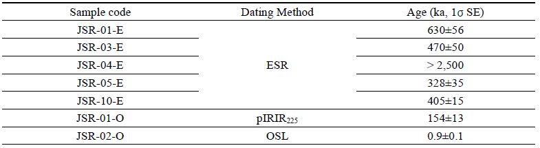
단층의 운동시기를 규명하기 위해 다양한 연대측정법들이 제안되고 있으며, 이번 연구에서는 ESR 연대측정법과 루미네선스(석영 OSL 및 K-장석 pIRIR225) 연대측정법을 활용하였다(Sohbati et al., 2012; Kim and Lee, 2020; Song et al., 2020; Murray et al., 2021). ESR 연대측정은 단층핵에서 채취한 단층비지 그리고 루미네선스 연대측정은 단층에 의해 절단된 퇴적층(unit A)과 이를 피복하고 있는 퇴적층(unit B)에서 채취한 미고결 퇴적물을 이용하였다(그림 6, 표 1). 단층핵에서 채취된 5개의 시료 중 측정연대 상한을 넘은 JSR-04-E를 제외한 ESR 연대는 630±56 ka (JSR-01-E), 470±50 ka (JSR-03-E), 328±35 ka (JSR-05-E), 405±15 ka (JSR-10-E)이다. 이들 ESR 연대는 굴착지점 단층의 최후 운동시기를 지시하지는 못하며 단지 단층비지 내의 석영 ESR 신호들을 완벽하게 초기화(complete resetting of ESR signals)하는 단층운동이 약 630~405 ka 혹은 그 이후에 있었을 가능성을 의미한다. 즉, 630~450 ka 이후에 단층비지 내 석영의 ESR 신호를 완벽하게 제거할 수 없었던(단층면에 가해진 수직응력이 3 MPa에 이르지 못한) 단층운동이 있었을 경우, 이 후기 단층운동의 시기가 언제인지는 ESR 연대자료만으로 파악하기가 불가능하며, 최후기 단층운동은 630~450 ka 시기 혹은 그 이후에 있었던 것으로 해석하는 것이 바람직하다. 한편, 단층을 피복한 unit B에서 얻은 석영 OSL 연대는 0.9±0.1 ka (JSR-02-O)이며, 단층에 의해 절단된 unit B에서 얻은 K장석 pIRIR225 연대는 154±13 ka (JSR-01-O)이다. 이는 이곳 단층의 최후기 운동이 154±13 ka와 0.9±0.1 ka 사이에 발생하였음을 지시한다.

Age dating results of the Quaternary sediments and fault rocks in the trench section.
5. 토 의
5.1 제4기 단층운동사
노두지점과 굴착단면에서 수행된 구조요소 분석을 바탕으로 제4기 동안의 단층운동사를 복원하면, 그림 8과 같이 두 가지 모델(Model 1과 2)로 제안될 수 있다. 먼저 모델 1은 기존에 존재했던 양산단층의 단층핵과 주변 모암을 하천 퇴적물인 unit B가 피복한 이후 역이동 성분을 포함한 우수향 주향이동 단층운동이 발생하여 unit B가 절단되고 겉보기 수직변위가 만들어졌음을 보여준다(그림 8a). 이후 침식·삭박작용으로 지형이 평탄화되고 unit A가 전체를 다시 피복한 것으로 해석된다. 그러나 공간에 따른 차별 침식~삭박으로 인해 노두지점에서는 현재 단층의 서측 상반이 상승한 수직변위가 뚜렷이 남아있지만 굴착단면에서는 수직변위가 확인되지 않을 가능성이 있다. 이 모델은 이곳 단층대를 따라 최소 1회의 단층운동이 제4기 동안 발생하였음을 지시한다. 또한 단층핵과 서편 데사이트질 응회암 사이에서 일부 단층비지와 섞여 나타나는 쐐기상의 미고결 퇴적물(그림 5b의 unit B-2)은 양산단층이 제4기 동안 우수향 주향이동단층으로 재활하는 동안 크기가 다른 변위를 가진 두 개 단층면 사이로 주변 퇴적물이 끌려와 단층 사이에 쐐기 상으로 끼인 결과로 해석된다.

Schematic diagrams showing two reconstruction models of faulting events based on the cross-cutting relationships between the faults and unit layers, indicating reveal at least (a) one or (b) two faulting events.
Model 2는 제4기 동안 양산단층대를 따라 첫 번째 역이동 성분을 포함한 우수향 주향이동 단층운동이 발생할 당시 단층면의 굴곡부에 형성된 지표 열극(fissure)이 만들어져 이곳에 퇴적물(unit B-2)이 충전되고 unit B-1이 퇴적되었으며, 이후 또 한 번의 단층운동으로 unit B-1가 절단되고 수직변위가 발생하였음을 보여준다(그림 8b). 이후 모델 1과 같이 침식~삭박작용으로 지형이 평탄화되고 unit A가 전체를 피복한 것으로 해석된다. 두 번째 모델은 제4기 동안 최소 2회의 단층운동이 발생하였음을 의미한다.
굴착지점에서 획득된 석영 OSL 및 장석 IRSL 연대(pIRIR225)는 최후기 단층운동 시기를 제한하는데 유용하다(표 1). 절단된 퇴적층과 절단되지 않은 퇴적층의 연대는 각각 154±13 ka (JSR-01-O)와 0.9±0.1 ka (JSR-02-O)로 이들 사이의 시기에 최후기 단층운동이 발생한 것으로 해석된다. 또한 Model 2를 따르면 단층대를 따라 열극이 만들어지는 단층운동은 Unit B-2의 퇴적 시기인 154±13 ka 경에 발생하였을 것이다. 한편, 단층비지에서 획득한 ESR 연대는 630~405 ka의 결과가 도출되었다. 이 결과는 최후기 운동시기를 지시하지는 못하나, 최후기 단층 운동시기(154±13 ka 이후 0.9±0.1 ka 이전)를 알려주는 석영과 장석에서 획득된 루미네센스 연대에 비해 상당히 오래된 연령인 점을 감안하면, 연구지역의 양산단층대를 따라 154±13 ka 이전의 제4기 동안에도 단층운동이 발생하였을 가능성을 지시한다.
굴착지점에서 남쪽으로 약 5.5 km 떨어진 유계지점에서 최후기 단층운동 시기는 단층에 의해 절단된 부식질 실트층에 대한 14C 연대측정 결과를 바탕으로 1,314 yr BP (AD 636) 이후로 해석되었다(Kyung, 2003). 또한 단층비지대에서 460±20 ka, 800±30 ka, 850±110 ka, 520±50 ka, 590±50 ka의 ESR 연대결과가 도출(Lee, 2002; Choi et al., 2012)된 바 있어 이번 연구의 연대 결과와는 다소 차이를 보인다. 이번 연구의 보경사지점과 굴착지점은 유계지점의 하천유역과는 다른 유역에 속하며 침식·삭박작용으로 지속적인 퇴적이 상대적으로 어려운 보다 높은 곳에 위치하고 있어 최후기 단층운동 시기에 대한 직접적인 상호 대비가 현실적으로 쉽지 않다. 하지만 이번 조사에서 유계지점과 보경사지점은 단층으로 연결되는 것으로 파악되며(그림 2), 이 두 지점을 지나가는 선형구조를 따라 우수향 주향이동 단층운동을 지시하는 굴절하천이 연속적으로 배열됨이 확인된다(그림 3). 따라서 유계지점과 이번 조사 지점의 단층은 유사한 운동사를 가지는 하나의 운동학적 분절에 속할 가능성이 높으며, 이 단층분절은 이번 조사에서 해석된 단층운동사(그림 8) 보다 훨씬 복잡한 운동사를 가질 수 있다.
5.2 변위율 산정
탄성반발이론(Reid, 1910)에 따르면, 탄성에너지가 단층대에 축적되고 축적된 에너지가 임계치에 도달하면 단층운동이 발생하면서 저장된 에너지가 지진파로 순간적으로 방출된다. 이때 변위율은 지진이 발생하기까지 에너지가 축적되는 시간 대비 지진발생시 단층의 변위량을 말한다. 변위율은 지각변형을 정량화하는 지표일 뿐만 아니라 단층운동의 패턴(Zechar and Frankel, 2009; Resor et al., 2018)과 단층대에 저장될 수 있는 에너지를 반영하기 때문에 지진재해 평가에서 가장 중요한 자료 중 하나이다(Molnar and Tapponnier, 1978; Zhang et al., 2008).
이번 연구에서 확인된 노두지점에서 단층의 수직 변위와 단층조선 그리고 굴착지점에서 도출된 연대자료를 이용해 변위율을 산정하면 다음과 같다. 단층운동으로 발생한 수직 변위(Svm; 0.76 m)와 단층면의 경사(80°)를 이용하여 계산된 겉보기 변위(Sm)는 0.77 m이며, 겉보기 변위 값과 단층조선의 선주각(45°)으로부터 계산된 실변위(St)는 1.1 m이다. 노두지점에서 연대측정을 위한 시료가 확보되지 않아 각 퇴적층의 연대를 산출하지 못하였지만, 굴착지점에서 확인된 퇴적층과 노두지점의 퇴적층이 동일 지층으로 대비된다면 154±13~0.9±0.1 ka 동안 1.1 m의 실변위가 발생한 것으로 볼 수 있다. 따라서 실변위량과 단층운동 시기로부터 계산된 변위율은 0.007~0.008 mm/yr이다. 하지만 절단된 지층 상위의 침식·삭박 작용으로 단층의 실제 변위는 과소추정될 가능성이 크기 때문에(Reitman et al., 2019; Kim and Seong, 2021), 위 변위율 값은 최소값으로 판단된다.
한편, 기존에 보고된 유계지점에서 단층에 의해 절단된 역층 내 실트층은 약 26,000 yr BP 이후 약 1.4~1.5 m의 수직 변위를 겪은 것으로 해석되어, 이를 통해 0.04~0.05 mm/yr의 수직 변위율이 계산된 바 있다(Kyung and Chang, 2001). 이를 실변위율로 환산하기 위해 단층면의 경사(44°)와 단층조선의 선주각(68°)을 이용해 복원한 절단된 역층 내 실트층의 실변위는 2.17 m이며, 실트층의 연대(26,000 yr BP)로 나누어 도출한 실변위율은 0.08 mm/yr로 계산된다. 그러나 정확한 변위율 산정에 있어서 두 번 이상의 단층운동과 두 단층운동 사이 시간 동안 발생한 변위량이 필요하다. 유계지점에서는 최후기 단층운동으로 발생한 변위량은 확인되지만 단층운동 사이의 시간을 정확히 알 수 없어 이 변위율은 과대평가된 것으로 판단된다. 따라서 유계지점과 이번 연구로 확인된 결과를 종합하면 북부 양산단층의 유계리-중산리 구간의 변위율은 0.007~0.08 mm/yr 사이의 범위를 가지는 것으로 해석된다.
5.3 최대 지진규모 산정
지진재해 평가에 있어 가장 핵심적인 요소는 특정 단층에서 발생 가능한 최대 지진 규모가 얼마인가를 결정하는 것이다. 이를 위해 단층운동으로 발생한 평균변위, 최대변위, 지표파열길이, 파열면적 등을 활용해 지진의 규모를 산정하는 다양한 연구들이 수행되었다(e.g., Kanamori, 1977; Slemmons, 1982; Bonilla et al., 1984; Khromovskikh, 1989; Mason, 1992; Wells and Coppersmith, 1994). 이중 Wells and Coppersmith (1994)의 경험식은 전 세계적으로 가장 많이 인용되며 모든 지구조 환경과 모든 단층 종류에 적용할 수 있고, 판 내부에 속하는 한반도 환경에서도 널리 활용되고 있다(Kyung, 2010; Kim and Jin, 2006; Jin et al., 2013; Lee et al., 2017; Song et al., 2020; Gwon et al., 2021). 이번 연구에서는 Wells and Coppersmith (1994)의 경험식 중 최대변위-모멘트 지진규모 경험식(식 1)과 파열길이-모멘트 지진규모 경험식(식 2)을 이용해 지진규모를 산정하였으며, 이에 사용된 변수는 노두지점에서 확인된 단층운동에 의한 실변위와 지형분석으로 확인된 선형구조 길이를 파열길이로 가정하여 적용하였다.
| (1) |
| (2) |
노두에서 확인된 단층의 실변위량 1.1 m를 경험식(식 1)에 대입하면 최대 모멘트 지진규모(Mw)는 약 6.7이다. 그러나 노두단면에서 변위된 unit B의 상부가 침식·삭박되어 정확한 수직변위 양을 알 수 없으며(그림 5b), 변위를 발생시킨 단층운동의 횟수를 결정할 수 있는 증거가 존재하지 않아 야외에서 관찰된 수직변위가 한 번의 단층운동에 의해 발생한 변위인지는 알 수 없다. 한편, 지형분석으로 굴절하천과 같은 단층운동을 지시하는 증거가 뚜렷한 선형구조의 총연장은 약 6.8 km이다(그림 3). 이 선형구조는 양산단층의 연장과 거의 일치하며(그림 2), 노두와 굴착조사로 선형구조를 따라 백악기 데사이트질 화산암류와 퇴적암류를 경계하는 양산단층의 단층핵이 제4기에 재활되었음이 확인되었다. 이 선형구조의 길이 6.8 km를 경험식(식 2)에 대입하면 최대 모멘트 지진규모(Mw)는 약 6.0이 도출된다. 그러나 이 선형구조가 기하학적으로는 하나의 단층분절로 취급될 수는 있으나, 지형분석 결과만으로 한 번의 지진으로 동시에 파열된 하나의 운동학적(지진성) 단층분절인지, 남쪽 또는 북쪽으로 보다 연장될지, 혹은 서로 다른 시기의 지진들에 의해 만들어진 몇 개의 분절들이 합쳐져 있는지는 현재로선 정확히 알 수 없다. 이러한 불확실성을 줄여나가기 위해서는 보다 세밀한 선형구조 분석과 더불어 지진관측 그리고 제4기 퇴적층을 절단하는 단층에 대한 추가 굴착조사를 통한 자세한 고지진학적 연구가 꾸준히 보완되어야 한다.
6. 결 론
포항시 청하면 유계리~송라면 중산리 일원 북부 양산단층을 따라 발생한 제4기 단층운동을 밝히기 위해 지형분석과 지표지질조사, 전기비저항탐사, 굴착조사, 연대측정을 실시하였다. 노두와 굴착단면에서 확인된 퇴적층과 단층의 절단관계와 기하 및 운동학적 특성을 바탕으로 제4기 동안의 단층운동사, 변위율 및 지진규모를 해석하였다. 연구결과를 요약하면 다음과 같다.
- 1) 항공사진과 LiDAR 영상을 활용한 지형분석을 실시하여 굴절하천, 단층와지 등의 연속적인 지형학적 지시자를 이용해 총 6.8 km 길이의 단층운동과 관련한 선형구조를 도출하였다. 이 선형구조를 따라 저비저항 이상대가 뚜렷이 확인되고 노두와 굴착조사를 통해 서편의 백악기 유천층군 화산암류와 동편의 백악기 하양층군 퇴적암류을 경계하는 약 10 m 폭의 양산단층 단층핵이 위치하고 있음이 확인되었다. 따라서 이 선형구조는 양산단층를 따라 발달한다.
- 2) 노두와 굴착단면에서 제4기 미고결 퇴적층을 절단하는 단층면들이 관찰되며, 단층면에는 역이동 성분을 포함하는 우수향 주향이동 운동을 지시하는 단층조선이 발달하고 제4기 퇴적층과 인접한 단층핵에는 제4기 퇴적층의 역들이 단층비지와 혼합된 특징을 보인다. 제4기 퇴적층과 단층의 절단관계 그리고 절단된 퇴적층과 단층을 피복하는 퇴적층에서 얻은 루미네센스 연대를 종합하면, 이곳 단층의 최후기 운동은 154±13 ka와 0.9±0.1 ka 사이에 발생하였으며, 제4기 동안 최소 2회 이상의 단층 운동이 발생한 것으로 해석된다.
- 3) 노두에서 확인되는 제4기 퇴적층의 수직 변위, 단층의 기하, 단층조선을 이용해 1.1 m의 실변위량이 계산되었으며, 실변위량 그리고 절단된 퇴적층과 피복하는 퇴적층의 연대 시간차를 이용해 계산된 변위율은 0.007~0.008 mm/yr로 계산되었다. 기존에 보고된 유계지점의 수직변위율을 단층자세와 단층조선을 통해 실변위율로 환산하면 0.08 mm/yr이다. 이번 연구에서 얻어진 변위율은 침식·삭박으로 최소 변위가 사용되어 과소 평가되었으며 기존 유계지점의 변위율은 최소연대를 사용하여 과대 평가된 것으로 판단되어, 두 결과를 종합하여 얻은 연구지역 양산단층의 변위율은 0.007~0.08 mm/yr 범위를 가질 것으로 추정된다.
- 4) 노두에서 확인되는 실변위량을 한 번의 지표파열 결과로 가정하고 실변위량을 최대변위-모멘트 지진규모 경험식에 적용하면 지진규모는 약 6.7로 계산되고, 선형구조의 길이를 지표파열 길이로 가정하여 파열길이-모멘트 지진규모 경험식에 적용하면 약 6.0의 규모가 도출된다. 하지만 노두에서 관찰된 실변위량은 침식·삭박으로 명확하지 않으며, 선형구조는 기하학적 분절만을 대변하기 때문에 운동학적(지진성) 분절의 길이는 불확실성이 존재한다. 따라서 이러한 불확실성을 줄여나가기 위해서는 향후 보다 세밀한 선형구조 분석과 함께 추가 굴착조사를 통해 보다 정밀한 고지진학적 정보(단층운동 시기, 횟수, 변위율, 지진규모)를 수집하는 노력이 필요하다.
Acknowledgments
이 논문은 행정안전부 지진 위험분석 및 관리기술 개발사업(2022-MOIS62-001)과 지진방재분야 전문인력 양성사업 지원을 받아 수행된 연구입니다.세심한 심사를 통해 본 논문의 질적 향상에 도움을 주신 두 분의 익명 심사위원과 편집위원께 감사드립니다.
References
-
Bonilla, M.G., Mark, R.K. and Lienkaemper, J.J., 1984, Statistical relations among earthquake magnitude, surface rupture length, and surface fault displacement. Bulletin of Seismological Society of America, 74, 2379-2411.
[https://doi.org/10.3133/ofr84256]

- Chang, C.-J., 2002, Structural characteristics and evolution of the Yangsan fault, SE Korea. Ph.D. Thesis, Kyungpook National University, Daegu, 259 p (in Korean with English abstract).
-
Chang, K.-H., Suzuki, K., Park, S.-O., Ishida, K. and Uno, K., 2003, Recent advances in the Cretaceous stratigraphy of Korea. Journal of Asian Earth Sciences, 21, 937-948.
[https://doi.org/10.1016/S1367-9120(02)00142-6]
- Chang, K.H., Woo, B.G., Lee, J.H., Park, S.O. and Yao, A., 1990, Cretaceous and Early Cenozoic stratigraphy and history of eastern Kyongsang Basin, S. Korea. Journal of the Geological Society of Korea, 26, 471-487.
- Chang, T.W., 2001, Quaternary tectonic activity at the eastern block of the Ulsan fault. Journal of the geolgical society of Korea, 37, 431-444 (in Korean with English abstract).
-
Cheon, Y., Cho, H., Ha, S., Kang, H.-C., Kim, J.-S. and Son, M., 2019, Tectonically controlled multiple stages of deformation along the YangsanFault Zone, SE Korea, since Late Cretaceous. Journal of Asian Earth Sciences, 170, 188-207.
[https://doi.org/10.1016/j.jseaes.2018.11.003]
-
Cheon, Y., Choi, J.-H., Kim, N., Lee, H., Choi, I., Bae, H., Rockwell, T.K., Lee, S.R., Ryoo, C.-R., Choi, H. and Lee, T.-H., 2020, Late Quaternary transpressional earthquakes on a long-lived intraplate fault: A case study of the Southern Yangsan Fault, SE Korea. Quaternary International, 553, 132-143.
[https://doi.org/10.1016/j.quaint.2020.07.025]
-
Cheon, Y., Ha, S., Lee, S., Cho, H. and Son, M., 2017, Deformation features and history of the Yangsan Fault Zone in the Eonyang-Gyeongju area, SE Korea. Journal of the Geological Society of Korea, 53, 95-114 (in Korean with English abstract).
[https://doi.org/10.14770/jgsk.2017.53.1.95]
- Choi, H.I., Oh, J.H., Shin, S.C. and Yang, M.Y., 1980, Geology and geochemistry of the Gyeongsang strata in Ulsan area. Korea Institute of Energy and Resources Bulletin, 20, 33 p (in Korean with English abstract).
-
Choi, J.-H., Kim, Y.-S. and Klinger, Y., 2017, Recent progress in studies on the characteristics of surface rupture associated with large earthquakes. Journal of the Geological Society of Korea. 53, 129-157.
[https://doi.org/10.14770/jgsk.2017.53.1.129]
- Choi, P., 2005, Geometric analysis of the Quaternary Eupchon Fault: an Interpretation of Trench Sections. Journal of the Geological Society of Korea, 41, 129-140 (in Korean with English abstract).
- Choi, P.Y., Choi, H.I., Hwang, J.H., Kee, W.S., Ko, H.J., Kim, Y.B., Lee, B.J., Song, K.Y., Kim, J.C. and Choi, Y.S., 2002, Explanatory Note of the Mokpo and Yeosu Sheets, 1:250,000. Korea Institute of Geoscience and Mineral Resources, 45 p.
- Choi, S.-J., Jeon, J.-S., Song, K.-Y., Kim, H.-C., Kim, Y.-H., Choi, P.-Y., Chwae, U.C., Han, J.-G., Ryoo, C.-R., Sun, C.-G., Jeon, M.S., Kim, G.-Y., Kim, Y.-B., Lee, H.-J., Shin, J.S., Lee, Y.-S. and Kee, W.-S., 2012, Active faults and seismic hazard map. NEMA, Seoul, 882 p.
- Choi, W.-H., 2003, Neotectonics of the Gyeongju-Ulsan area in the southeastern part of Korean Peninsula. Thesis of Ph.D., Seoul National University, Korea, 205 p (in Korean with English abstract).
-
Chough, S.K. and Sohn, Y.K., 2010, Tectonic and sedimentary evolution of a Cretaceous continental arc-backarc system in the Korean peninsula: New view. Earth-Science Reviews, 101, 225-249.
[https://doi.org/10.1016/j.earscirev.2010.05.004]
-
DeMets, C., Gordon, R.G., Argus, D.F. and Stein, S., 1994, Effect of recent revisions to the geomagnetic reversal time scale on estimates of current plate motions. Geophysical research letters, 21, 2191-2194.
[https://doi.org/10.1029/94GL02118]
-
Gu, D., Han, R. and Woo, S., 2021, Geological records of coseismic shear localization along the Yangsan fault, Korea. Journal of Geophysical Research: Solid Earth, 126, e2020JB021393.
[https://doi.org/10.1029/2020JB021393]
-
Gwon, O., Park, K., Naik, S.P., Shin, H.-C. and Kim, Y.-S., 2021, A study on the characteristics of fault activity in the southern part of the Ulsan fault using paleoseismic method. Journal of the Geological Society of Korea, 57, 109-121 (in Korean with English abstract).
[https://doi.org/10.14770/jgsk.2021.57.2.109]
- Hwang, B.H., Lee, J.D. and Yang, K., 2004, Petrological study of the granitic rocks around the Yangsan fault: Lateral displacement of the Yangsan fault. Journal of the Geological Society of Korea, 40, 161-178 (in Korean with English abstract).
-
Hwang, B.H., Lee, J.D., Yang, K. and McWilliams, M., 2007a, Cenozoic strike-slip displacement along the Yangsan fault, southeast Korean Peninsula. International Geology Review, 49, 768-775.
[https://doi.org/10.2747/0020-6814.49.8.768]
-
Hwang, B.H., McWilliams, M., Son, M. and Yang, K., 2007b, Tectonic implication of A-type granites across the Yangsan fault, Gigye and Gyeongju areas, southeast Korean Peninsula. International Geology Review, 49, 1094-1102.
[https://doi.org/10.2747/0020-6814.49.12.1094]
- Hwang, J.H., Kim, D.H., Cho, D.R. and Song, K.Y., 1996, Explanatory Note of The 1:1:250,000 Andong Sheet. Korea Institute of Geoscience and Mineral Resources, 67 p.
- Im, C.B. and 48 others, 2003, Development of Technology and Background for Seismic Safety Evaluation. Technical Note of the Ministry of Science and Technology of Korea, KINS/GR-255, 1433 p (in Korean with English abstract).
- Jin, K., Kim, Y.-S., Kang, H.C. and Shin, H.C., 2013, Study on developing characteristics of the Quaternary Gusan Fault in Uljin, Gyeongbuk, Korea. Journal of the Geological Society of Korea, 49, 197-207 (in Korean with English abstract).
-
Kanamori, H., 1977, The energy release in great earthquakes. Journal of Geophysical Research, 82, 2981-2987.
[https://doi.org/10.1029/JB082i020p02981]
- Kang, H.-C. and Paik, I.S., 2013, Review on the geological ages of the formations in the Gyeongsang Basin, Korea. Journal of the Geological Society of Korea, 49, 17-29 (in Korean with English abstract).
- Kang, J.-H. and Ryoo, C.-R., 2009, The movement history of the southern part of the Yangsan Fault Zone interpreted from the geometric and kinematic characteristics of the Sinheung Fault, Eonyang, Gyeongsang Basin, Korea. Journal of the Petrological Society of Korea, 18, 19-30 (in Korean with English abstract).
- Kee, W.-S., Kim, B.C., Hwang, J.H., Song, K.-Y. and Kihm, Y.-H., 2007, Structural characteristics of Quaternary reverse faulting on the Eapcheon Fault, SE Korea. Journal of the Geological Society of Korea, 43, 311-333 (in Korean, with English abstract).
-
Khromovskikh, V.S., 1989, Determination of magnitudes of ancient earthquakes from dimensions of observed seismodislocations. In: D. Denham (Editor), Quantification of Earthquakes and the Determination of Source Parameters. Tectonophysics, 166, 269-280.
[https://doi.org/10.1016/0040-1951(89)90219-9]
-
Kim, C.-M., Han, R., Jeong, G.Y., Jeong, J.O. and Son, M., 2016, Internal structure and materials of the Yangsan fault, Bogyeongsa area, Pohang, South Korea. Geosciences Journal, 20, 759-773.
[https://doi.org/10.1007/s12303-016-0019-8]
- Kim, D.-E. and Seong, Y.B., 2001, Cumulative Slip Rate of the Southern Yangsan Fault from Geomorphic Indicator and Numerical Dating. Journal of the Korean Geomorphological Association, 56, 201-213 (in Korean with English abstract).
- Kim, D.H., Hwang, J.H., Park, K.H. and Song, K.Y., 1998, Explanatory Text of 1:250,000 Pusan Sheet. Korea Institute of Energy and Resources, 62 p.
-
Kim, M.-C., Jung, S., Yoon, S., Jeong, R.-Y., Song, C.W. and Son, M., 2016, Neotectonic Crustal Deformation and Current Stress Field in the Korean Peninsula and Their Tectonic Implications: A Review. Journal of Petrological Society of Korea, 3, 169-193 (in Korean with English abstract).
[https://doi.org/10.7854/JPSK.2016.25.3.169]
-
Kim, M.-J. and Lee, H.-K., 2020, ESR dating of fault gouge-review. Journal of the Geological Society of Korea, 56, 211-234 (in Korean with English abstract).
[https://doi.org/10.14770/jgsk.2020.56.2.211]
- Kim, Y.-S. and Jin, K., 2006, Estimated earthquake magnitude from the Yugye Fault displacement on a trench section in Pohang, SE Korea. Journal of the Geological Society of Korea, 42, 79-94 (in Korean with English abstract).
- Kim, Y.-S., Jin, K., Choi, W.-H. and Kee, W.-S., 2011a, Understanding of active faults: a review for recent researches. Journal of the Geological Society of Korea, 47, 723-752 (in Korean with English abstract).
-
Kim, Y.-S., Kihm, J.-H. and Jin, K., 2011b, Interpretation of the rupture history of a low slip-rate active fault by analysis of progressive displacement accumulation: an example from the Quaternary Eupcheon Fault, SE Korea. Journal of the Geological Society, London, 168, 273-288.
[https://doi.org/10.1144/0016-76492010-088]
-
Kim, Y.-S., Part, J.Y., Kim, J.H., Shin, H.C. and Sanderson, D.J., 2004, Thrust geometries in unconsolidated Quaternary sediments and evolution of the Eupchon Fault, southeast Korea. The Island Arc, 13, 403-415.
[https://doi.org/10.1111/j.1440-1738.2004.00435.x]
- Kyung, J.B., 1997, Paleoseismological study on the Midnorthern part of Ulsan Fault by trench method. The Journal of Engineering Geology, 7, 81-90 (in Korean with English abstract).
- Kyung, J.B., 2003, Paleoseismology of the Yangsan Fault, southeastern part of the Korean Peninsula. Annals of Geophysics, 46, 983-996.
- Kyung, J.B. and Chang, T.W., 2001, The latest fault movement on the Northern Yangsan fault zone around the Yugye-ri area, southeast Korea. Journal of the Geological Society of Korea, 37, 563-577 (in Korean with English abstract).
- Kyung, J.-B., Lee, K. and Okada, A., 1999a, A paleoseismological study of the Yangsan fault - analysis of deformed topography and trench survey. Journal of the Korean Geophysical Society, 2, 155-168 (in Korean with English abstract).
- Kyung, J.-B., Lee, K., Okada, A., Watanabe, M., Suzuki, Y. and Takemura, K., 1999b, Study of fault characteristics by trench survey in the Sangchon-ri area in the southern part of Yangsan fault, southeastern Korea. Journal of Korean Earth Science Society, 20, 101-110 (in Korean with English abstract).
- Lee, B.J., Ryoo, C.-R. and Chwae, U., 1999, Quaternary faults in the Yangnam area, Kyongju, Korea. Journal of the Geological Society of Korea, 35, 1-14 (in Korean with English abstract).
-
Lee, C.H., Seong, Y.B., Oh, J.-S. and Kim, D.E., 2019, Tectonic Geomorphology on Yugye-Bogyeongsa Area of Yangsan Fault Zone. Journal of the Korean Geomorphological Association, 26, 93-106.
[https://doi.org/10.16968/JKGA.26.1.93]
- Lee, H.-K., 2002, ESR dating for fault rocks. Korea Institute of Nuclear Safety, KINS/HR-474, 42 p (in Korean)
-
Lee, J., Rezaei, S., Hong, Y., Choi, J.-H., Choi, J.-H., Choi, W.-H., Rhee, K.-W. and Kim, Y.-S., 2015, Quaternary fault analysis through a trench investigation on the northern extension of the Yangsan fault at Dangu-ri, Gyungju-si, Gyeongsanbuk-do. Journal of the Geological Society of Korea, 51, 471-485 (in Korean with English abstract).
[https://doi.org/10.14770/jgsk.2015.51.5.471]
- Lee, K., 1998, Historical earthquake data of Korean. Journal of the Korea Geophysical Society, 1, 3-22 (in Korean with English abstract).
- Lee, K., 2010, Comments on seismicity and crustal structure of the Korean peninsula. Geophysics and Geophysical Exploration, 13, 256-267 (in Korean with English abstract).
- Lee, K. and Jin, Y.G., 1991, Segmentation of the Yangsan fault system: Geophysical studies on major faults in the Kyeongsang Basin. Journal of the Geological Society of Korea, 27, 434-449.
-
Lee, K. and Yang, W.-S., 2006, Historical Seismicity of Korea. Bulletin of the Seismological Society of America, 96, 846-855.
[https://doi.org/10.1785/0120050050]
-
Lee, Y., Cheon, Y., Ha, S., Kang, H.-C., Choi, J.-H. and Son, M., 2017, Geometric and kinematic characteristics of the Quaternary fault at Seooe site, in Goseong-gun, Gyeongsangnam-do. Journal of the Geological Society of Korea, 53, 115-127 (in Korean with English abstract).
[https://doi.org/10.14770/jgsk.2017.53.1.115]
- Lee, Y.H., 2003, Quaternary faults in the eastern area of the Ulsan fault (Korea). M.S. Thesis, Pusan National University, Korea, 74 p (in Korean with English abstract).
- Mason, D.B., 1992, Earthquake magnitude potential of active faults in the Intermountain Seismic Belt from surface parameter scaling. M.S. Thesis, University of Utah, Salt Lake City, U.S.A.
-
Molnar, P. and Tapponnier, P., 1978, Active tectonics of Tibet. Journal of Geophysical Research: Solid Earth, 83, 5361-5375.
[https://doi.org/10.1029/JB083iB11p05361]
-
Murray, A., Arnold, L.J., Buylaert, J.P., Guérin, G., Qin, J., Singhvi, A.K., Smedley, R. and Thomsen, K.J., 2021, Optically stimulated luminescence dating using quartz. Nature Reviews Methods Primers, 1, 1-31.
[https://doi.org/10.1038/s43586-021-00068-5]
-
Okada, A., Watanabe, M., Sato, H., Jun, M.S., Jo, W.R., Kim, S.K., Jeon, J.S., Chi, H.C. and Oike, K., 1994, Active fault topography and trench survey in the central part of the Yangsan fault, south Korea. Journal of Geography, 103, 111-126 (in Japanese).
[https://doi.org/10.5026/jgeography.103.2_111]
-
O’Neill, C., Müller, D. and Steinberger, B., 2005, On the uncertainties in hot spot reconstructions and the significance of moving hot spot reference frames. G-cubed 6, Q04003.
[https://doi.org/10.1029/2004GC000784]
-
Park, Y., Ree, J.-H. and Yoo, S.-H., 2006, Fault slip analysis of Quaternary faults in southeastern Korea. Gondwana Research, 9, 118-125.
[https://doi.org/10.1016/j.gr.2005.06.007]
- Reedman, A.J. and Um, S.H., 1975, The geology of Korea: Seoul, Korea. Geological and Mining Institute of Korea, 139 p.
-
Reid, H., 1910, On Mass-Movements in Tectonic Earthquakes. The California Earthquake of April 18, 1906. Report of the state earthquake investigation commission, 192 p.
[https://doi.org/10.1086/621732]
-
Reitman, N.G., Mueller, K.J., Tucker, G.E., Gold, R.D., Briggs, R.W. and Barnhart, K.R., 2019, Offset Channels May Not Accurately Record Strike-Slip Fault Displacement: Evidence From Landscape Evolution Models. Journal of Geophysical Research: Solid Earth, 124, 13427-13451.
[https://doi.org/10.1029/2019JB018596]
-
Resor, P.G., Cooke, M.L., Marshall, S.T. and Madden, E.H., 2018, Influence of fault geometry on the spatial distribution of long-term slip with implications for determining representative fault-slip rates. Bull. Seismol. Soc. Am, 108, 1837-1852.
[https://doi.org/10.1785/0120170332]
- Ryoo, C.-R., 2009, A report for the Quaternary Gaegok 6 Fault developed in the Mid-eastern part of Ulsan Fault Zone, Korea. Economic and Environmental Geology, 42, 635-643 (in Korean with English abstract).
- Ryoo, C.-R., Chwae, U., Choi, S.-J. and Son, M., 2001, Quaternary faults in Hwalseong-ri, Oedong-up, Gyeongju, Korea. KIGAM Bulletin, 5, 24-33 (in Korean with English abstract).
- Ryoo, C.-R., Kang, J.-H., Son, M., Choi, S.-J. and Chwae, U., 2006, Geological Structure of the Quaternary Sinheung Fault developed along Yangsan Fault in the northern Eonyang, Ulsan, Korea. KIGAM Bulletin, 10, 3-17 (in Korean with English abstract).
- Ryoo, C.-R., Lee, B.J., Son, M., Lee, Y.H., Choi, S.-J. and Chwae, U., 2002, Quaternary faults in Gaekok-ri, Oedongeup, Gyeongju, Korea. Journal of the Geological Society of Korea, 38, 309-323 (in Korean with English abstract).
- Ryoo, C.-R., Yang, K., Lee, S.-W. and Kim, I.-S., 1996, Quaternary fault in the vicinity of the Ulsan fault. The Journal, College of Education, Pusan National University, Pusan, Korea, 33, 311-327 (in Korean with English abstract).
-
Sim, H., Song, W., Son, M., Park, C., Choi, W. and Khulganaknuu, C., 2017, Reactivated Timings of Yangsan Fault in the Northern Pohang Area, Korea. Economic and Environmental Geology, 50, 97-104 (in Korean with English abstract).
[https://doi.org/10.9719/EEG.2017.50.2.97]
- Slemmons, D.B., 1982, Determination of design earthquake magnitudes for microzonation. In proceeding International Earthquake Microzonation, Conference, Seattle, WA, Earthquake Engineering Research Institute, 1, 110-130.
-
Sohbati, R., Murray, A.S., Buylaert, J.-P., Ortuño, M., Cunha, P.P. and Masana, E., 2012, Luminescence dating of Pleistocene alluvial sediments affected by the Alhama de Murcia fault (eastern Betics, Spain) - a comparison between OSL, IRSL and post-IR-IRSL ages. Boreas, 41, 250-262.
[https://doi.org/10.1111/j.1502-3885.2011.00230.x]
-
Son, M., Song, C.W., Kim, M.-C., Cheon, Y., Cho, H. and Sohn, Y.K., 2015, Miocene tectonic evolution of the basins and fault systems, SE Kora: dextral, simple shear during the East Sea (Sea of Japan) opening. Journal of the Geological Society, 172, 664-680.
[https://doi.org/10.1144/jgs2014-079]
- Son, M., Song, C.W., Kim, M.-C., Cheon, Y., Jung, S., Cho, H., Kim, H.-G., Kim, J.S. and Sohn, Y.K., 2013, Miocene Crustal Deformation, Basin Development, and Tectonic Implication in the southeastern Korean Peninsula. Journal of the Geological Society of Korea, 49, 93-118 (in Korean with English abstract).
-
Song, Y., Ha, S., Lee, S., Kang, H.-C., Choi, J.-H. and Son, M., 2020, Quaternary structural characteristics and paleoseismic interpretation of the Yangsan Fault at Dangu-ri, Gyeongju-si, SE Korea, through trench survey. Journal of the Geological Society of Korea, 56, 155-173.
[https://doi.org/10.14770/jgsk.2020.56.2.155]
- Wells, D.L. and Coppersmith, K.J., 1994, New empirical relationships among magnitude, rupture length, rupture area, and surface displacement. Bulletin of Seismological Society of America, 84, 974-1002.
-
Zechar, J.D. and Frankel, K.L., 2009, Incorporating and reporting uncertainties in fault slip rates. Journal of Geophysical Research: Solid Earth, 114 (B12).
[https://doi.org/10.1029/2009JB006325]
- Zhang, P.-Z., Li, C.-Y. and Mao, F.Y., 2008, Strath terrace formation and strike-slip faulting. Seismology and Egology, 30, 44-57.