동해 울릉분지 남서부 중기 마이오세 저류층의 퇴적환경 해석
초록
울릉분지 남서부 동해가스전과 인접한 2공의 탐사정으로부터 취득한 시추코어를 활용하여 퇴적환경을 해석하였다. 총 160 m에 이르는 시추코어를 분석하여 암질, 색, 입도, 퇴적구조, 조직, 생흔화석상, 화석의 빈도를 종합하여 9개의 퇴적상으로 분류하였다. 9개의 퇴적상은 Mm: 균질상의 이암상, Ml: 옅은 엽층리를 보이는 이암상, MS1, 2: 이암과 사암이 교호하는 퇴적상, Sm: 괴상의 사암상, Sh: 수평층리를 보이는 사암상, Sm-b: 생흔화석이 산재된 괴상의 사암상, Sc: 사층리를 보이는 사암상, G: 기질 지지 또는 입자 지지의 역암상이다. 이를 다시 7가지 퇴적상조합으로 설정하여 해석된 퇴적환경은 해안전면부에서 외해에 걸쳐 나타나는 삼각주 환경인데, 전위삼각주, 외 전면삼각주, 내 전면삼각주로 구분된다. 퇴적상조합 1(FA1)은 주로 이질 퇴적물로 구성되어 있으며, 사암상이 협재되어 나타나는데 전위삼각주 환경으로 해석되며, 퇴적상조합 2(FA2)는 이암과 사암이 교호하는 퇴적층으로 파랑연흔이 특징적이며, 퇴적상조합 3(FA3)은 세립질의 성숙한 사암상으로 이루어져 있으며, 둘 다 외 전면삼각주 환경에서 형성된 것으로 해석되고, 외곽부의 경사진 삼각주 퇴적물이 재동되어 이암과 사암이 교호하는 퇴적상을 생성한 것으로 추정된다. 세립질의 Skolithos ichnofacies가 산재된 사암상이 연속적으로 관찰되는데, 이는 상대적으로 고에너지 환경을 지시하며, 중부-하부 해안전면부 환경에서 잘 나타난다. 퇴적상조합 4(FA4)는 세립 내지 중립질의 사암상으로 구성되며, 생흔화석이 드물게 관찰된다. 퇴적상조합 5(FA5)와 퇴적상조합 7(FA7)은 중·조립질의 사암상으로 이루어져 있으며, 층리의 경사와 각도가 다양하게 나타난다. 퇴적상조합 6(FA7)은 부유식 침전을 통해 퇴적된 이암과 사암이 교호하는 퇴적상과 중·조립질의 사암상으로 이루어져 있다. FA4, FA5, FA6, FA7은 모두 내 전면삼각주 환경에서 축적된 것으로 해석된다. 특히 중·조립질의 순수 사질 퇴적물로 이루어져 있는 많은 부분은 분류하도 퇴적층으로 해석된다.
Abstract
This study is to interpret the sedimentary environments using some core data from two exploration wells adjacent to the Donghae Gas Field in the southwestern Ulleung Basin, Korea. Based on sedimentological and ichnological characteristics, the cores were classified into nine facies (Mm: homogeneous mudstone, Ml: faintly laminated mudstone, MS1, 2: interbedded sandstone and mudstone, Sm: homogenous sandstone, Sh: horizontally stratified sandstone, Sm-b: bioturbated massive sandstone, Sc: cross-bedded sandstone, G: matrix- to clast-supported conglomerate). The facies can be grouped into seven facies associations. The study section is interpreted mostly as a deltaic environment from shoreface to offshore, and it can be divided into prodelta, outer delta front, and inner delta front. FA1, composed of mostly mud deposits with thin sandy layers, is accumulated in a prodelta environment. FA2 is sand deposits interbedded with mud, and FA3 are deposits of fine mature sands. Both of them are to have been deposited in an outer delta front environment. In this environment, alternating sediments of mudstone and sandstone were formed by continuous reactivation of deltaic sediments at the steep slope. In an outer delta front, close to land, fine-grained sandstones are observed with frequent Skolithos ichnofacies. This ichnofacies indicates a high-energy environment, possibly in a lower to middle shoreface environment. FA4 is fine to medium sandy deposits containing rare trace fossils. FA5 and FA7 are medium to coarse sandy deposits with various cross-beddings. FA6 is composted of muds with sandy layers and medium to coarse sandy deposits. Inner delta front deposits are FA4, FA5, FA6, FA7. In this environment they consists of medium to pure coarse sandy sediments, which are interpreted as distributary channel deposits.
Keywords:
Ulleung Basin, middle Miocene, facies association, ichnofacies, depositional environment키워드:
울릉분지, 중기 마이오세, 퇴적상조합, 생흔화석상, 퇴적환경1. 서 론
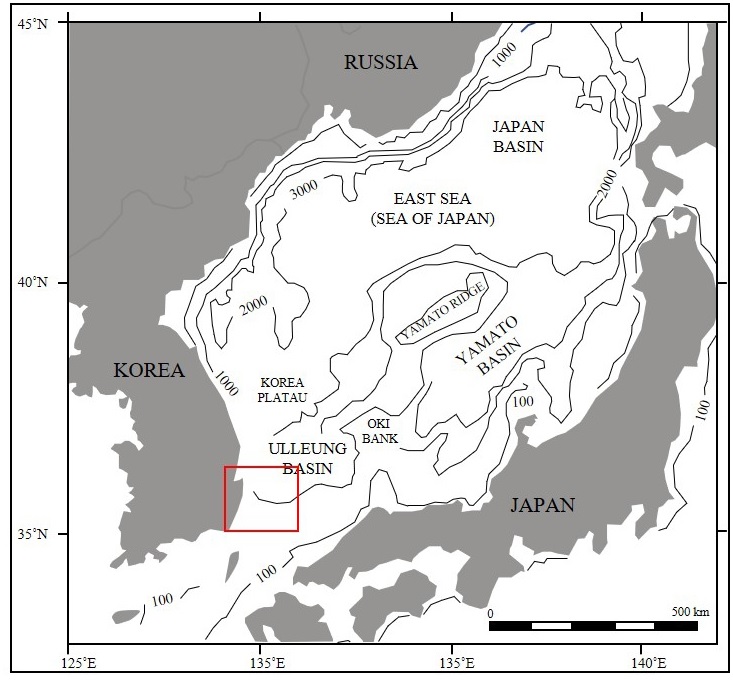
울릉분지 남서 연변부는 수심 200 m 이하의 대륙붕과 수심 200-1500 m의 급경사 대륙사면으로 이루어져 있으며 탄성파 탐사와 중자력 탐사 자료는 약 8 km 이상 두께의 퇴적물이 집적되어 있음을 보여주고 있다(Park, 1992). 이 지역에 대하여 연구들은 1970년도 초부터 최근까지 2D·3D 심부 탄성파 탐사 자료, 물리 검층, 시추공자료, 미화석 자료들을 분석하여 지구조, 순차층서, 퇴적작용, 분지 생성 진화 등 다양한 분야에 대하여 수행되어 왔다(Chough and Barg, 1987; Chough et al., 1997a, 1997b; Yoon et al., 2003; Lee et al., 2004, 2011). 초기 석유탐사 활동은 1970년대 외국 석유회사인 Gulf, Shell, Texaco사들이 중심이 되어 남해와 동해 남부 대륙붕 일원에서 2D 탄성파탐사를 실시하고 돌고래-1, KV-1, IIH-1XA, 도미-1, 소라-1 등 총 5공을 시추하였으나 도미-1과 소라-1 공에서만 가스 또는 원유 징후를 발견하였고 다른 곳에서는 실패했다. 1980년대 한국석유공사는 울릉분지 남동부 6-1광구에서 기 취득했던 지구물리탐사 자료와 시추자료에 대한 재평가를 실시하고, 추가 3D 탄성파탐사와 돌고래 II, 돌고래 III, 돌고래 III-1 돌고래 III-2, 고래 I, 고래 V, 고래 V-1 등 총 7공을 시추하였다. 그 결과 돌고래 II, 돌고래 III, 고래 V, 고래 V-1 4개의 구조에서 가스층을 발견하였으나, 가채매장량이 최소 경제성에 미치지 못하였다(Park et al., 1995). 1990년대 이후, 탄성파 자료에서 나타나는 AVO (Amplitude Variation Offset) 및 진폭이상, 순차층서학과 같은 새로운 탐사개념을 도입하여 국내 대륙붕에 대한 종합평가를 실시하였으며, 고래구조에 대한 탐사시추를 통해 양질의 가스를 발견하고 동해 가스전을 개발하게 되었다.
울릉분지 동해-1 가스전 생산 종료가 임박함에 따라 신규 유망구조 탐사 및 생산 저류층 특성화 연구의 필요성이 대두되었으나, 지금까지 저류층 특성화 연구는 분지의 대륙붕, 대륙사면에서의 탄성파 탐사자료와 물리검층 자료를 이용한 분지 규모의 연구에 중점을 두었기 때문에 시추코어를 활용한 정밀 저류층에 대한 연구는 부족한 편이었다. 따라서 이번 연구에서는 울릉분지 남서부에 위치한 두 공의 탐사정에서 취득한 저류층 구간의 시추코어 자료를 바탕으로 암질, 입자 크기, 퇴적구조, 색, 광물조성, 유기물 함량을 분석하고 물리검층 분석결과를 대비하여 퇴적환경을 해석하고자 하였다. 또한 시추 코어에서 정밀 기재한 생흔화석상 자료를 퇴적상 분석 자료와 통합하여 각 저류층 구간별 퇴적환경 변화에 대해 보다 정밀한 퇴적환경 해석을 시도하였다. 특히, 생물들은 환경 조건의 변화에 대해서 각기 다른 방식으로 반응하기 때문에 퇴적상 분석에 활용하는 생흔화석상은 퇴적 당시의 원지 환경에 대한 정보를 직접적으로 지시해주며, 몸체화석이나 퇴적구조만으로는 해석하기 어려운 퇴적학적 사건들을 기록하기도 한다. 이번 연구 분석을 통해 울릉분지 남서부에 위치한 중기 마이오세 저류층 퇴적 환경을 해석할 뿐만 아니라, 향후 각 환경에 따른 저류층 품질을 분석하여 울릉분지 내 석유·가스 탐사 시 저류층 구간의 물성이나 퇴적환경 해석에 유용한 기본 자료로 활용하고자 한다.
2. 지질개요
동해는 일본열도의 배후에 발달하는 신생대 제3기 후기 퇴적분지로써 일본분지, 야마토분지, 울릉분지로 구분된다(Chough, 1983). 일본분지와 야마토분지에서 수행된 심해 시추 프로젝트(DSDP)와 해양 시추프로그램(ODP)에 의하면 동해의 열림은 후기 올리고세(약 32 Ma)에 일본분지 북동부의 지각이 얇아지면서 시작되었으며, 28~23 Ma동안 열개 작용에 의한 확장이 이어졌다(Jolivet and Tamaki, 1992). 이 시기에 동해 남부에 위치한 야마토분지와 울릉분지에서도 지각확장이 일어나 분지의 열림이 시작되었다(Tamaki et al., 1992). 초기 마이오세(23~18 Ma)에는 동해의 확장이 빠르게 진행되었으나, 중기 마이오세 말에는 각각 북동-남서 방향 횡압력이 작용하였다(Chough and Barg, 1987; Ingle Jr, 1992; Yoon and Chough, 1995). 횡압력의 결과로 울릉분지 남부 일대는 북동-남서 주향을 가지는 대규모 습곡과 충상단층(thrust fault)이 발달하였고, 이후 융기된 충상단층(thrust fault)의 힌지대는 침식되어 부정합면이 형성되었으며, 삭박된 다량의 퇴적물은 주변 저지대로 공급된 것으로 해석되었다(Lee et al., 2001; Yoon et al., 2002; Kim et al., 2007). 후기 마이오세에 이르러 울릉분지 남서부 대륙붕 일대는 북서-남동방향의 습곡축을 가지는 고래 V 구조가 형성되었고. 현재까지 융기활동이 지속되고 있다고 제안되었다(Lee et al., 2011).
탄성파 자료에 의해 해석된 울릉분지 중심부의 기반암은 해저면 10 km 하부에 존재하며, 기반암 상부의 신생대 후기 퇴적층 두께는 약 8~10 km에 이르는 것으로 알려져 있다. 기반암은 백악기 및 고제3기 화산암으로 예상되며, 상부는 마이오세의 심해 저탁류 사암층, 대륙붕 및 해안평야 그리고 플라이오세 이후의 외대륙붕 환경의 쇄설성 퇴적층으로 이루어져 있다(Park, 1992). 분지 남서부에서 획득한 탄성파 자료에 의하면 상부 마이오세층의 고수로들은 주로 남서에서 북동의 방향성을 보인다(Park, 1992).
울릉분지를 포함한 인근 해역의 퇴적층에 대한 초기 층서 연구는 탄성파 탐사 자료와 시추공 자료(TSU Ko-1)를 이용한 연구인데, 퇴적층을 하부로부터 기반암, X층군, N층군, K층군, D층군으로 구분하였다(표 1). X층군은 고제3기~전기 마이오세 시기의 비해성 또는 연안 퇴적층, N층군은 전기~중기 마이오세 시기의 반원양성 이암 및 저탁류 사암 퇴적층, K층군은 중기~후기 마이오세 시기의 천해성 이암과 사암, D층군은 후기 마이오세~현생 시기의 천해성 사암과 이암으로 해석했다(KNOC, 2014).
울릉분지의 퇴적환경은 연안 및 천해환경으로부터 심해환경에 이르기까지 다양한 것으로 해석된다. 대륙붕-대륙사면 퇴적물은 주로 한반도 남동부 기원의 연안 삼각주의 전진퇴적에 의해 퇴적되었으며, 대양저 퇴적물은 주로 중력에 의한 질량류 퇴적체로 해석된다(Chough et al., 2000).
울릉분지 일대의 해저지형은 한국과 일본 사이의 완만한 대륙붕과 북동 방향으로 수심이 점차 깊어지는 사면이 특징적이다(그림 1). 대륙붕 지역은 완만한 경사인 내대륙붕과 하도와 협곡이 발달한 외대륙붕으로 구분된다. 울릉분지 남서부에 위치하는 대륙붕 퇴적물은 한반도 남동부에서 주로 퇴적물을 공급받은 삼각주의 북동 방향으로의 전진퇴적에 의해 퇴적된 것으로 추정되며, 대륙붕 위에 형성된 삼각주가 대륙붕단을 지나 계속 전진 퇴적을 하는 대륙붕단-삼각주 모델로 설명 가능하다(KNOC, 2014). 대륙사면은 사면사태-사면붕락과 같은 퇴적 동시성 변형이나 질량류의 이동에 따른 침식이 활발했던 것으로 추정된다(Chough et al., 2000). 또한 대륙사면을 우회하여 분지 평원으로 이동하는 퇴적물의 주된 통로인 해저협곡의 형성도 활발했던 것으로 해석된다(KNOC, 2014). 탄성파 단면상에서 대륙사면으로 해석되는 부분은 대륙붕이나 대양저 환경으로 해석되는 곳에 비해 연장성이 좋지 않으며, 탄성파상으로 불규칙하고 명확하지 않은 형태를 보인다. 이는 퇴적 당시 빈번했던 재동이나 침식으로 인해 퇴적층의 수평적 연속성이 매우 불량하기 때문으로 해석된다(KNOC, 2014). 울릉분지의 대양저를 이루는 천부 퇴적층은 여러 번 중첩된 다양한 질량류 퇴적체로 구성되어 있다(Chough et al., 2000). 질량류에 의해 형성된 쇄설류 퇴적물이 반복적으로 누적되어 심해 선상지를 이루고 있으며, 퇴적층은 로브 형태로 중첩되어 있다. 지역에 따라 반원양성 퇴적물과 저탁류 퇴적물이 로브 사이에 분포한다(Chough et al., 1997a; Lee and Kim, 2007; Yoo et al., 2011; Kang et al., 2015).
3. 연구자료 및 방법
동해 울릉분지 남서부에 분포하는 저류층 특성화 분석을 위해 가스전 인근에 위치한 한국석유공사에 의해 취득된 두 공의 탐사정을 선택하였다. 대상 탐사정인 Well #1과 Well #2의 거리는 1,170 m로 서로 인접해있으며, 동일 저류층을 목표로 시추되었다. Well #1의 시추코어 구간은 2,345 m~2,363.44 m, 2,413 m~2,430.6 m, 2,462 m~2,481.45 m, 2,575 m~2,593 m 총 73.49 m이고, Well #2의 시추코어 구간은 2,740 m~2,765.32 m, 2,768 m~2,794.37 m, 2,796 m~2,824.39 m 총 80.08 m이다. 주요 저류층 퇴적물을 포함한 시추코어 구간은 중기 마이오세 상부 면을 나타내며, 해당 시기는 미화석 연구에 의해 정의되었다(Yun and Yi, 2002). 시추코어는 1 m 단위로 현장에서 취득한 후, 말레이시아 현지 코어 연구기관(CoreLab Malaysia Ltd)에 의뢰하여 다양한 지질학적 물성을 측정하였다.
코어 실험실에서는 현장에서 취득된 시추코어를 장축에 평행하게 1/3, 2/3 크기로 수평 절개하였다. 2/3로 절개된 코어로부터 직경 1인치의 플러그 샘플을 취득하여 공극률과 유체투과도를 측정하였고, 나머지 1/3 절개 코어는 DCIS-300 (Digital Core Imaging System)을 이용해 백색광 하에서 사진 촬영하는데 활용되었다.
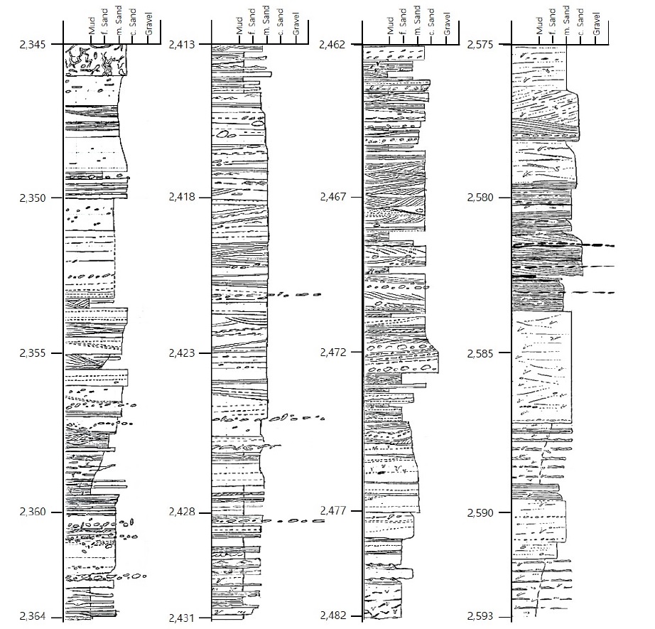
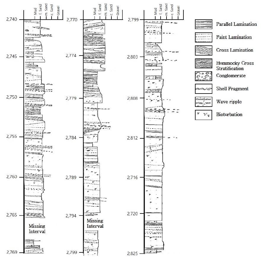
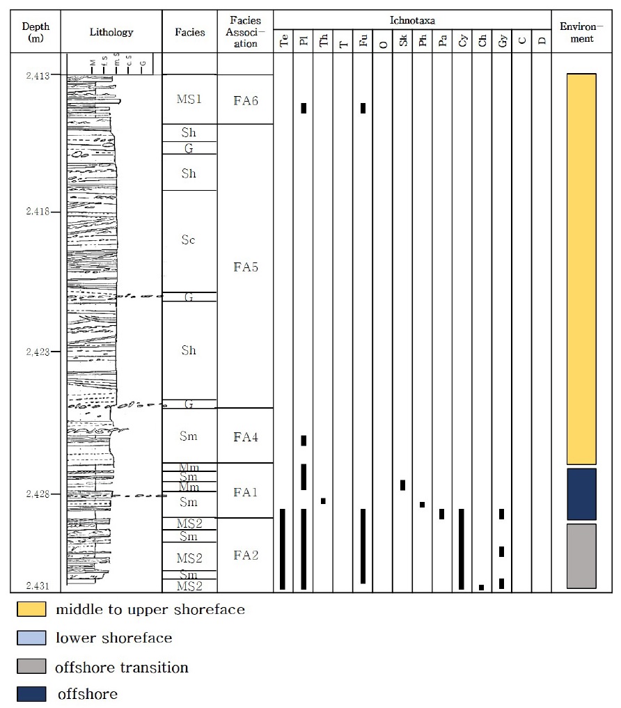
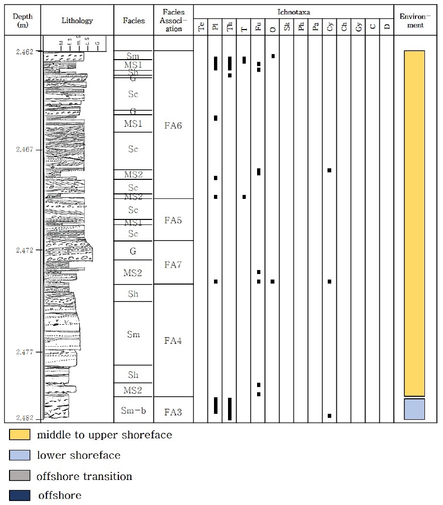
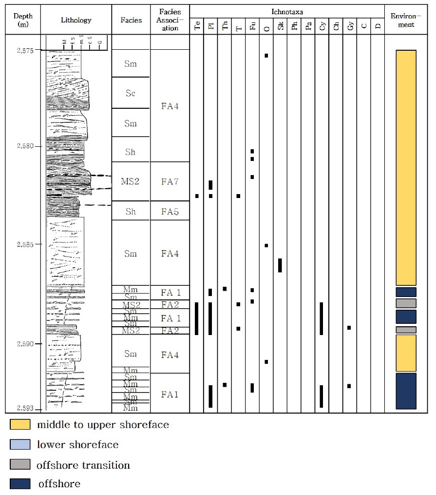
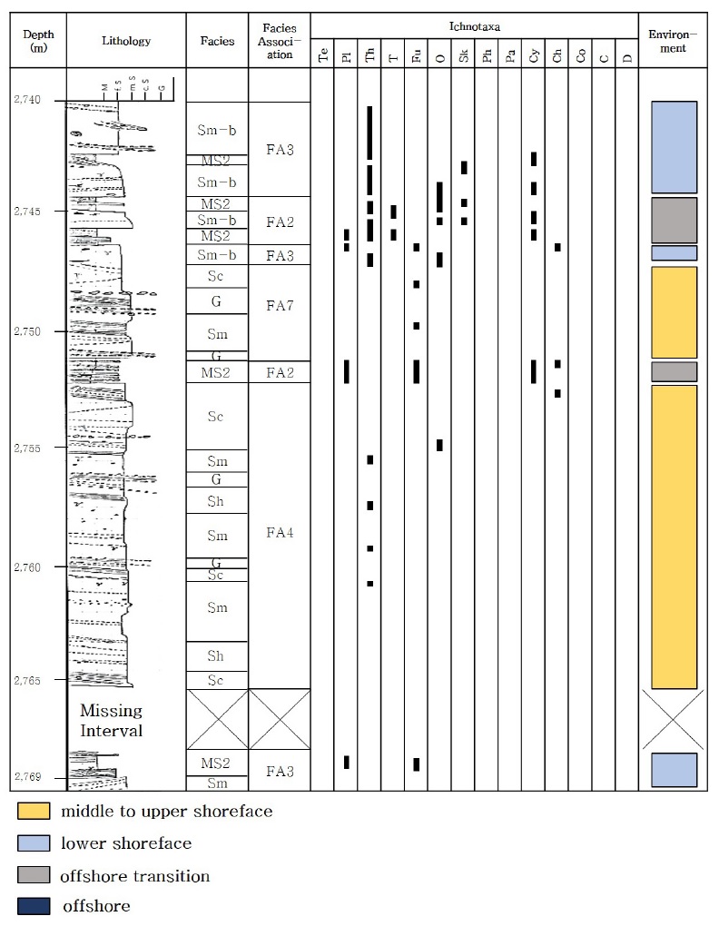
탐사정 Well #1과 Well #2에서 취득된 시추코어는 시추공 당 약 80 m 길이를 가지며, 연속적이지 않은 네 개의 구간으로 구분된다(표 2A, 2B). 1 m 간격으로 절단된 1/3 슬라브 시추코어 단면을 관찰하여 색도, 조직, 퇴적구조, 생흔화석의 종류를 기재하였고, 총 160 m에 이르는 구간에 대해 1:100 주상도를 작성하였다(그림 2A, 2B). 퇴적상과 생흔상을 통합하여 초기 퇴적환경의 일반적인 특성뿐만 아니라 염도, 퇴적률과 같은 구체적인 정보를 파악하였다. 도출된 내용을 바탕으로 퇴적상조합을 설정하였고, 이를 통해 측방 및 수직 상변화를 이해하고 울릉분지 남서부에 위치한 중기 마이오세 저류층 구간의 퇴적환경 해석을 수행하였다.
4. 연구결과 및 해석
4.1 퇴적상 분석
울릉분지 동해 가스전 인근에 위치한 두 공의 탐사정으로부터 취득된 1/3 절개 코어 퇴적층을 암질, 입자 크기, 색, 분급, 퇴적구조, 흔적 화석의 종류, 흔적 화석의 밀도를 기반으로 총 9가지 퇴적상으로 구분하였다. 세립질 암상에서부터 조립질 암상 순서로, 특별한 퇴적구조를 보이지 않는 균질상의 이암상(Mm; Homogeneous mudstone), 옅은 엽층리를 보이는 이암상(Ml; Faintly laminated mudstone), 이암과 사암이 교호하는 퇴적상(MS; Interbedded mudstone and sandstone), 엽층리를 보이는 사암상(Sl; Laminated sandstone), 괴상의 사암상(Sm; Massive sandstone), 생흔화석이 산재된 괴상의 사암상(Sm-b; Bioturbated massive sandstone), 수평층리를 보이는 사암상(Sh; Horizontally stratified sandstone), 사층리를 보이는 사암상(Sc; Cross-bedded sandstone), 입자 지지 또는 기질 지지를 보이는 역암상(G; Matrix- to clast-supported conglomerate)로 분류된다.
9개의 퇴적상의 특징들은 표 3에 요약되어 있고, 시추 코어로부터 관찰되는 주요 퇴적구조와 퇴적상, 그리고 생흔화석들은 그림 3, 4, 5, 6에 제시되어 있다.

The main characteristics and interpretation of sedimentary facies with trace-fossils in the studied interval, upper middle Miocene, southwestern Ulleung Basin.
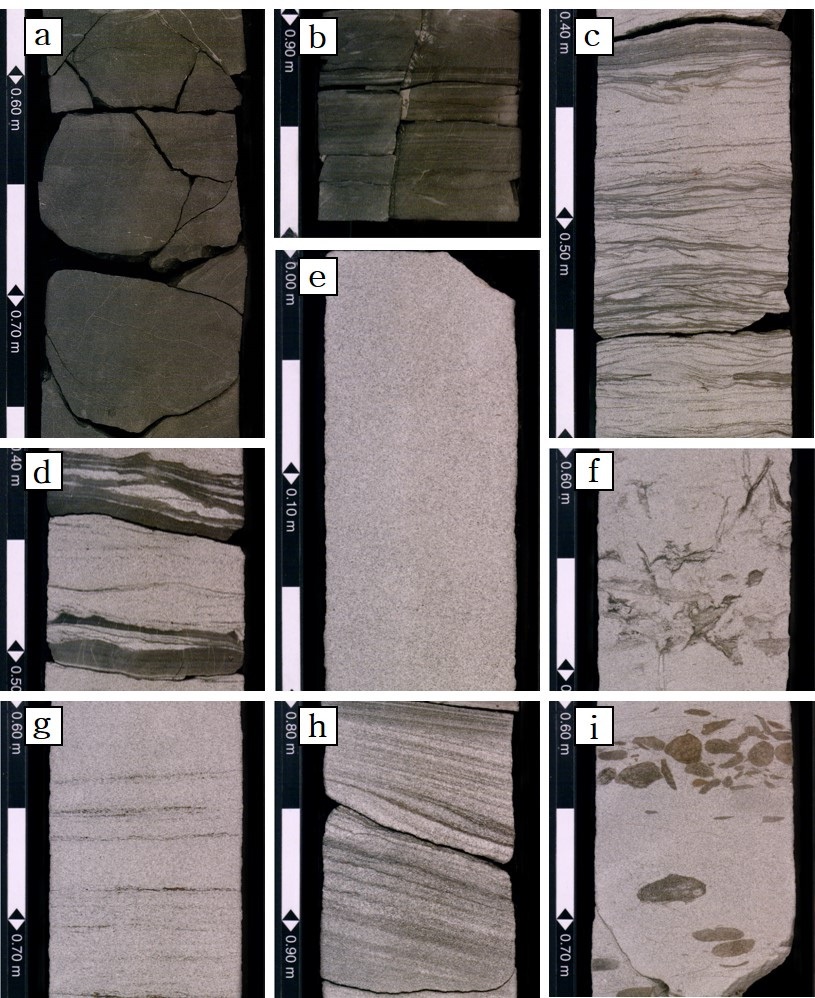
Core photographs showing representative sedimentary facies in the upper middle Miocene sediments. (a) Facies Mm; (b) Facies Ml; (c) Facies Sl; (d) Facies MS; (e) Facies Sm; (f) Facies Sm-b; (g) Facies Sh; (h) Facies Sc; and (i) Facies G.
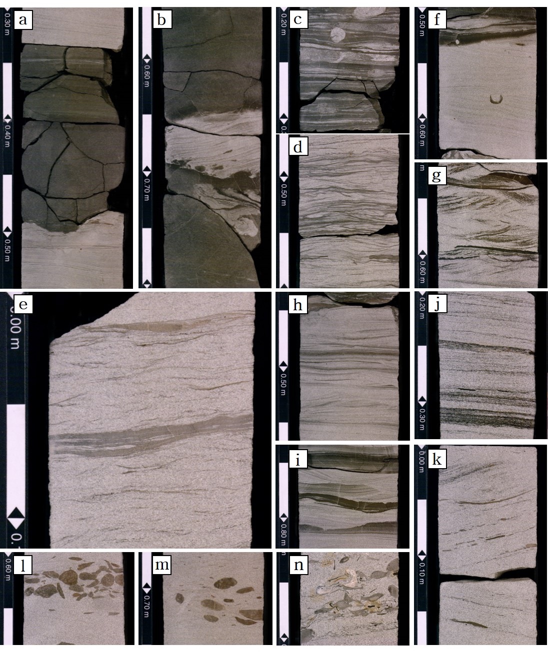
Core photographs of individual facies showing physical sedimentary structures. a, Homogeneous and faint laminated mudston; b, Convolute bedding with crumpling beds; c, d, & e, Gradational spectrum of heterolithic deposits consisting of alternated sand with draped mud in the Facies Sl (c, lenticular bedding; d, wavy bedding; e, flaser bedding); F, Hummocky and swaley cross stratification; g, h, & i, Cross-lamination formed by small wave ripples (g, Chevron cross-lamination; h, Double mud drapes; i, Bundled lamination); j, Planar laminated and low-angle cross-bed with wood fragments; k, Trough cross-beds and planar bounding surface with mud pebbles in the Facies Sc; l, Clast-supported conglomerate layer; m, Matrix-supported conglomerate layer; and n, Planar cross-stratified conglomerate layer containing shell fragments mixed with mud pebbles in the Facies G.
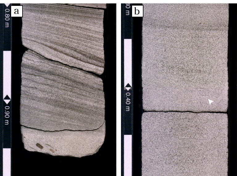
Cross-bedded (a) and faint horizontal-bedded (b) sandstone with a disrupted lamina (arrow) due to the process of cryptobioturbation.
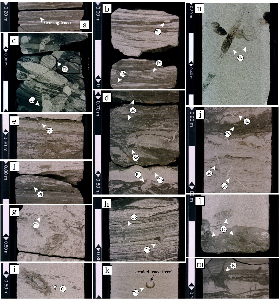
Photographs of trace fossils in the cored intervals. a, Faintly laminated mudstone crosscut by grazing microbes trace fossils (Facies Ml); b, Silty mudstone with Fugichnia (Fu), Navichnia (Na) and Bergaueria (Be) showing plug-shaped depressions along the base of sandstone layers. This is commonly related to a high-energy nearshore environment (Facies Sl); c, Thalassinoides (Th) passively filled with fine-grained sand indicating a high-energy environment. d. High-diversity trace fossil suite in offshore transition deposits including Schaubcylindrichnus (Sc), Fugichnia(Fu) and Conichnus (Co), commonly observed in the Facies MS; e, Cross-section through retrusive spreite burrow, Diplocraterion habichi (Di) commonly recorded in a marginal-marine environment; f, Small Planolites (Pl) in silty mudstone with lamination, commonly observed in the Facies MS and Sl; g, Chondrites (Ch) as clusters of burrows of a similar diameter, rarely occurring in the Facies Sm; h, Conichnus (Co) is a kind of equilibrium trace, a common element of nearshore to upper shoreface deposits in the Facies Sm and Sh; i, Ophiomorpha (O), a typical component related to high-energy environments, commonly observed trace fossils in the Facies Sm and Sh; j, High-energy Skolithos assemblage including Schaubcylindrichnus (Sc), Cylindrichnus (Cy) and Skolithos (Sk), commonly occurred in sand-dominated heterolithic beds; k, Upper part of Palaeophycus (Pa) eroded by a high-energy flow; l, Teichichnus (Te) observed in the Facies Sm, frequently occurred associated with delta deposits and typical for fair-weather rather than storm deposits; m, Rosselia (Ro) typically occurring in lower to middle shoreface deposits, commonly observed in the Facies Sm and MS; n, Skolithos (Sk) is a typical component related to high-energy environments and commonly observed trace fossils in the Facies Sm.
4.2 퇴적상조합과 퇴적환경
앞서 분류된 9개의 퇴적상 사이의 경계면 특징, 퇴적상의 수직적 변화, 반복적인 산출 정도와 생흔화석상을 고려하여 7가지 상조합을 설정하였다(그림 7, 8, 9, 10, 11, 12, 13). 퇴적상조합 1(FA1)은 주로 이질 퇴적물로 구성되어 있으며, 사암상이 협재되어 나타난다. 이암상 내에서는 수평 생흔화석이 드물게 관찰된다. 퇴적상조합 2(FA2)는 이암과 사암이 교호하는 퇴적층으로 파랑연흔이 특징적이며, 퇴적상조합 중 생흔화석의 밀도와 다양성이 가장 높다. 퇴적상조합 3(FA3)은 세립질의 성숙한 사암상으로 이루어져 있으며, 생흔화석의 수직 연속성이 높다. 생흔 교란 지수(BI)는 2~5까지 다양하게 나타난다. 퇴적상조합 4(FA4)는 세립 내지 중립질의 사암상으로 구성되며, 나무 파편 조각들이 미량 포함되어 있다. 생흔화석이 드물게 관찰되며, 종의 다양성이 낮다. 퇴적상조합 5(FA5)와 퇴적상조합 7(FA7)은 중·조립질의 사암상으로 이루어져 있으며, 층리의 경사와 각도가 다양하게 나타난다. 침식에 약한 패각편과 나무 파편들을 다량 포함하고 있으며, 일부 구간에서는 역들이 층리를 이루고 있다. 해당 퇴적상조합들에서는 생흔화석이 관찰되지 않는다. 퇴적상조합 7(FA7)에서는 파랑작용이 우세한 환경을 대표하는 퇴적구조들이 명확하게 관찰된다. 퇴적상조합 6(FA7)은 부유식 침전을 통해 퇴적된 이암과 사암이 교호하는 퇴적상과 중·조립질의 사암상으로 이루어져 있다. 조간대에서 자주 관찰되는 사층리와 같은 퇴적구조가 명확하게 관찰되며, 해당 퇴적상조합에서 나타나는 생흔상 또한 퇴적상과 유사한 환경을 지시한다.
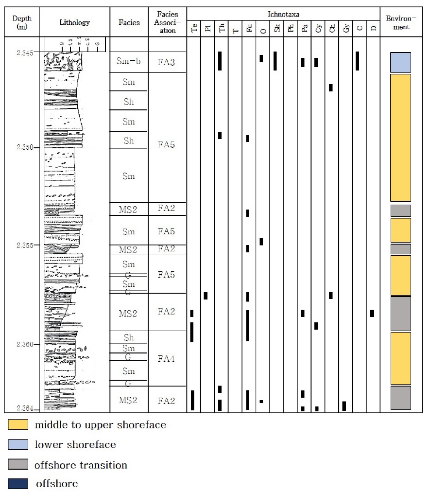
The stratigraphic section in Well #1-1 showing the sedimentological, ichnological characteristics and interpretation of the depositional environments of the upper Middle Miocene in Ulleung Basin, Korea.
The stratigraphic section in Well #1-2 showing the sedimentological, ichnological characteristics and interpretation of the depositional environments of the upper Middle Miocene in Ulleung Basin, Korea.
The stratigraphic section in Well #1-3 showing the sedimentological, ichnological characteristics and interpretation of the depositional environments of the upper Middle Miocene in Ulleung Basin, Korea.
The stratigraphic section in Well #1-4 showing the sedimentological, ichnological characteristics and interpretation of the depositional environments of the upper Middle Miocene in Ulleung Basin, Korea.
The stratigraphic section in Well #2-1 showing the sedimentological, ichnological characteristics and interpretation of the depositional environments of the upper Middle Miocene in Ulleung Basin, Korea.
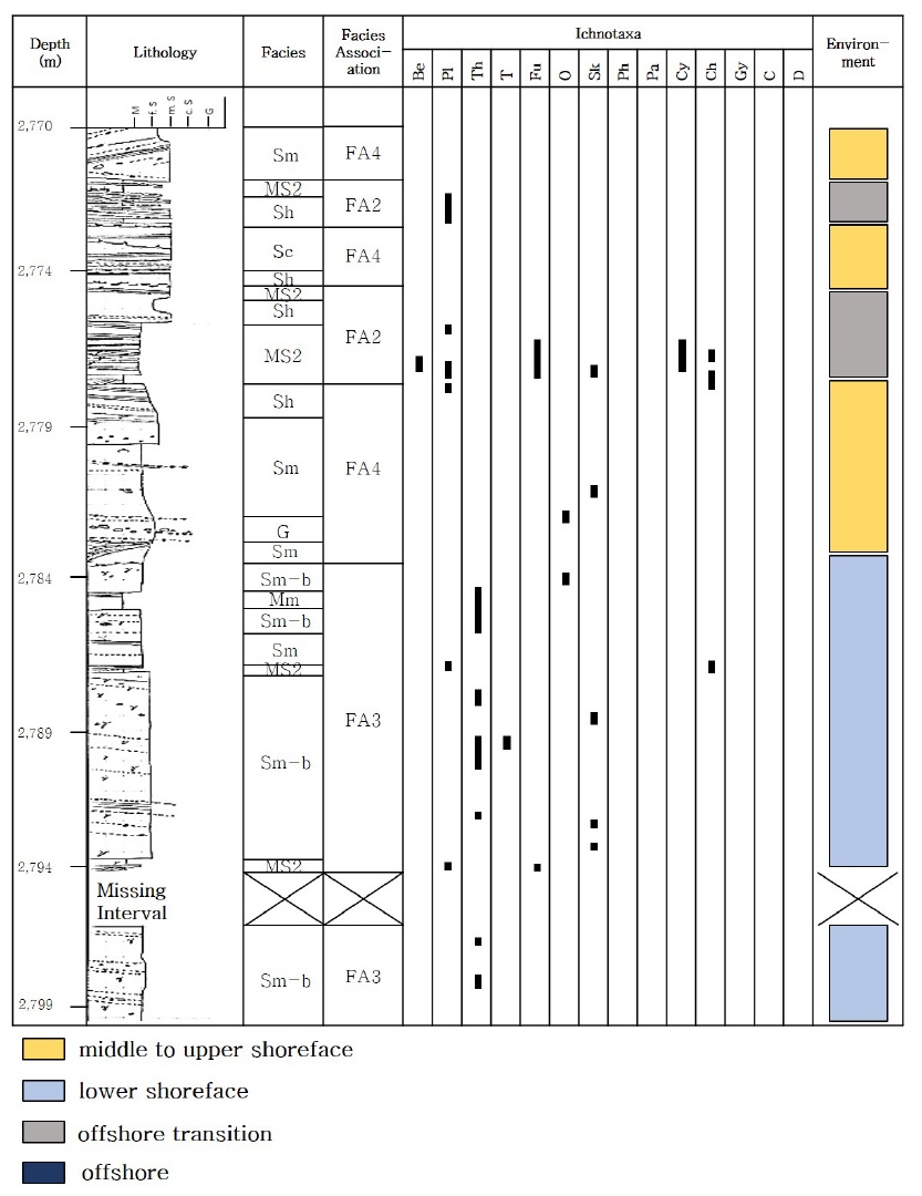
The stratigraphic section in Well #2-2 showing the sedimentological, ichnological characteristics and interpretation of the depositional environments of the upper Middle Miocene in Ulleung Basin, Korea.
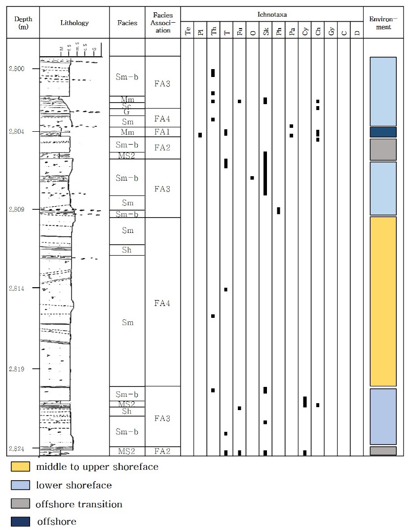
The stratigraphic section in Well #2-3 showing the sedimentological, ichnological characteristics and interpretation of the depositional environments of the upper Middle Miocene in Ulleung Basin, Korea.
퇴적상조합 1. 전위삼각주 상부(inner prodelta)
퇴적상조합 1은 주로 평행한 옅은 엽층리를 보이는 이암상(Ml)과 괴상의 사암상(Mm)으로 구성되며, 수평 층리를 보이는 사암상(Sh) 또는 사층리를 보이는 사암상(Sc)이 협재되어 관찰된다(그림 14). 부유식 침전을 통해 퇴적된 수평 엽층리를 보이는 이암상 Ml의 하부면은 불규칙한 곡선의 형태를 보이나(그림 3-A), 저탁류 최후기 단계에 퇴적된 균질상의 이암상 Mm의 하부면은 뚜렷한 침식면을 가진다. 드물게 층내변형(convolution) 구조를 보이기도 하는데, 이는 이암이 완전히 고화되기 전 급격하게 퇴적물이 퇴적되어 하부층의 수분이 빠져나가면서 퇴적층이 변형되어 형성된다(그림 14). 퇴적상조합 1에서 관찰되는 사암상(Sh, Sc)은 평균적으로 10cm 정도의 두께를 보이며, 이암상과 접하는 하부 경계면은 강한 유수의 흐름에 의해 삭박되어 명확한 수평의 침식면을 보이며, 경계면을 따라 쪼개짐이 관찰되기도 한다(그림 14). 사암층은 소구사층리(hummocky cross-stratidfication, HCS)와 오목사층리(swaley cross-stratidfication, SCS) 퇴적구조를 포함하는데, 이러한 특징을 보이는 사암상은 홍수나 폭풍과 같이 불규칙적인 고에너지 이벤트에 의해 공급된 퇴적물로 해석된다(Plint, 2010; Hampson and Howell, 2017). 퇴적상조합 1은 생흔 화석이 거의 관찰되지 않으나, 수평 엽층리를 보이는 이암상(Ml)에서만 지표를 기어다니며 습식을 하는 수평 생흔구조와 라이닝이 없는 형태의 생흔 화석이 관찰된다. 이러한 생흔 화석은 교란이 없는 저에너지 환경에서 잘 발달한다. 퇴적상 및 생흔상 해석 결과를 종합해 볼 때, 퇴적상조합 1은 전위삼각주 상부 환경 내 전위삼각주 이암 퇴적층으로 해석된다(그림 23, 24).
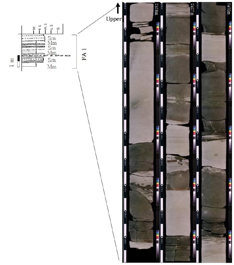
The photograph and representative column type of Facies Association 1 (FA1). FA1 is interpreted as the deposits of inner prodelta environment.
퇴적상조합 2. 외 전면삼각주의 distal bar (distal bar deposit of the outer delta front)
퇴적상조합 2는 사암과 이암이 교호하는 퇴적상 MS와 불규칙적으로 괴상의 사암상(Sm), 수평 엽층리를 보이는 사암상(Sh)으로 구성된다(그림 15). 대부분 퇴적상 MS로 이루어져 있으며, 퇴적상 Sm, Sh가 퇴적상 MS사이에 협재되어 나타난다. 수 cm 간격으로 사암과 이암이 교호하는 퇴적층은 퇴적물을 부유시키고 해류를 야기하는 비교적 약한 폭풍파에 기인한 퇴적층으로 해석할 수 있다(Plint, 2010). 때문에 암상 간의 경계가 명확하지 않으며, 파랑 구조가 흔하게 관찰된다(그림 15). 퇴적상 MS에서는 Cruziana ichnofacies에 속하는 생흔 화석들이 나타난다. Cruziana ichnofacies는 응집성-반응집성 퇴적물에서 잘 관찰되며, 중준위 에너지 레벨에서 잘 발달한다. 일반적으로 정상파도저면과 폭풍 파랑 기저부 사이인 외해 전이대 환경을 지시한다(Dalymple, 2010; Knaust, 2017a, 2017b). 퇴적상조합 2는 중간 에너지와 해류에 의해 외곽에 위치한 퇴적물이 재동되어 형성된 것으로, 일반적으로 분류 하단 인근 환경으로 해석된다(Okoro and Igwe, 2014). 불규칙하게 관찰되는 사암층은 말단에 위치한 해저수로에서 공급된 로브 또는 저탁류 퇴적층으로 해석된다. 퇴적상 및 생흔상 해석 결과를 종합해 볼 때 퇴적상조합 2는 외 전면삼각주(outer delta front) 환경 내 말단 해저수로 사이에 발달하는 퇴적층으로 해석된다(그림 23, 24).
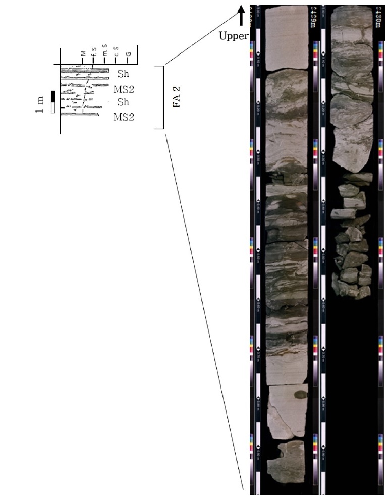
The photograph and representative column type of Facies Association 2 (FA2). This is characterized by alternating wave-ripple sandstone with mudstone (MS2), interpreted as a distal bar deposits in the outer delta front.
퇴적상조합 3. 외 전면삼각주의 분류 하도 말단부 하구사주(terminal distributary mouth bar in the outer delta front)
퇴적상조합 3은 주로 생흔 교란을 받은 괴상의 사암상(Sm-b)과 수평층리, 저각의 사층리를 보이는 사암상(Sh, Sc)으로 구성된다. 퇴적상 Sm-b는 평균 1 m로 두껍게 분포하며, 퇴적상 Sh, Sc는 평균 30 cm 두께를 가진다(그림 16). 퇴적상조합 3을 구성하는 퇴적상들은 분급이 매우 양호한 세립-중립질 사암상으로 퇴적물의 조직이 유사하여 퇴적상들 간의 경계가 뚜렷하지 않고 모호하다. 퇴적상조합 3의 암상 및 조직은 퇴적상조합 4와 유사하나, 수직상 생흔구조(Skolithos ichnofacies)가 나타나는 것이 특징적이다(그림 16). Ophiomorpha, Thalassinoides, Skolithos는 퇴적상조합 3 전 구간에 대해 연속적으로 나오며, Conichnus, Teichichnus, Bergaueria, Planolite, Cylindrichnus 는 일부 구간에서만 확인된다. Skolithos ichnofacies는 분급이 양호한 순수 사암상에서 잘 관찰되며, 고에너지 환경을 지시하는 생흔상이다. 주로 하부-중부 해안전면부에서 잘 나타나며 해저협곡이나 심해 선상지, 대륙 사면 환경을 지시하기도 한다(MacEachern et al., 2010; Knaust, 2017a). 퇴적상조합 3은 다른 퇴적상에 비해 생물교란을 받은 구간이 빈번하게 나타나는 것으로 보아 상대적으로 약한 파력이 작용하며 퇴적물 집적률이 낮은 일상적 기후 조건을 반영하는 것으로 볼 수 있다(그림 16)(MacEachern et al., 2010; Yoon and Chun, 2019). 생흔 화석에 의해 유입된 이질 퇴적물을 제외하고는 세립질의 순수 사질 퇴적물로 이루어져 있으며, 석탄 조각 또는 패각편은 거의 관찰되지 않는다. 상기 해석된 내용을 종합하여 볼 때 퇴적상조합 3은 외 전면삼각주 환경 내 분류하도 말단부에 위치한 하구사주 퇴적층으로 해석된다(그림 23, 24).
퇴적상조합 4. 내 전면삼각주의 분류 하구사주(distributary mouth bar of the inner delta front)
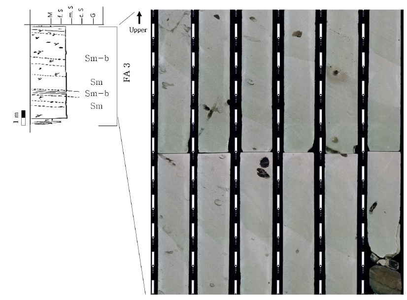
The photograph and representative column type of Facies Association 3 (FA3). This is characterized by bioturbated massive sandstone (Sm-b) and massive sandstone (Sm), interpreted as the terminal distributary mouth bar deposits.
퇴적상조합 4는 괴상의 사암상(Sm)과 수평층리를 보이는 사암상(Sh), 사층리를 보이는 사암상(Sc)으로 구성된다. 퇴적상조합 4는 최대 3 m의 두께를 보이며 수직적 연속성이 높다(그림 17). 퇴적상조합 4를 구성하는 퇴적상들은 분급이 매우 양호한 중·조립질 사암으로 순수 사질 퇴적물로 이루어져 있다. 수평층리와 사층리를 보이는 사암상(Sh, Sc)은 미량의 나무 파편 조각과 같은 육상 기원의 퇴적물들이 포함되어 있으며, 인접한 괴상의 사암상(Sm)보다 입자의 크기가 큰 것을 보아 폭풍 또는 홍수에 의해 퇴적된 것으로 해석된다(Allen and Friend, 1976; Yang et al., 2019). 퇴적상조합 4는 퇴적상 간의 경계가 모호한데 이는 유사한 기원지에서 공급된 퇴적물들로 이루어져 있으며, 분급이 매우 양호하여 입자 간 차이를 보이지 않는 것으로 해석된다(그림 17). 더불어 퇴적상조합 4에서는 시각적으로 인지되는 생흔 화석의 발달은 미약하나, 고에너지 환경을 지시하며, 순수 사질퇴적층에서 잘 관찰하는 Ophiomorpha와 Skolithos가 드물게 관찰되는 것으로 보아 높은 퇴적률과 다짐작용을 받은 것으로 해석된다(MaEachern et al., 2010). 괴상의 사암상과 옅은 수평 엽층리를 보이는 사암상에서는 미세 생교란작용(cryptobioturbation)이 흔하게 관찰된다(그림 4). 미세 생교란작용은 1 mm 크기 이하의 생물체에 의한 생교란작용으로서 층리 변형을 심하게 일으키진 않지만, 층리와 같은 1차 퇴적구조들이 파괴되기 때문에 특별한 구조를 보이지 않는 괴상의 사암상을 나타낼 수 있다. 미세 생교란작용은 유체투과도와 유효공극률의 증가를 야기하여 저류층의 품질을 높일 수 있다(Knaust, 2017c). 퇴적상조합 4를 구성하는 퇴적상들은 유속이 빠른 환경에서 형성된다. 생흔 화석은 거의 관찰되지 않으나, 드물게 고에너지 환경을 지시하는 생흔화석들이 관찰되며, 침식되기 쉬운 석탄 조각이 미량 포함되어 있는 것으로 보아 퇴적상조합 4는 내 전면삼각주 환경 내 분류하도 근위에 위치한 하구사주 퇴적층으로 해석된다(그림 23, 24).
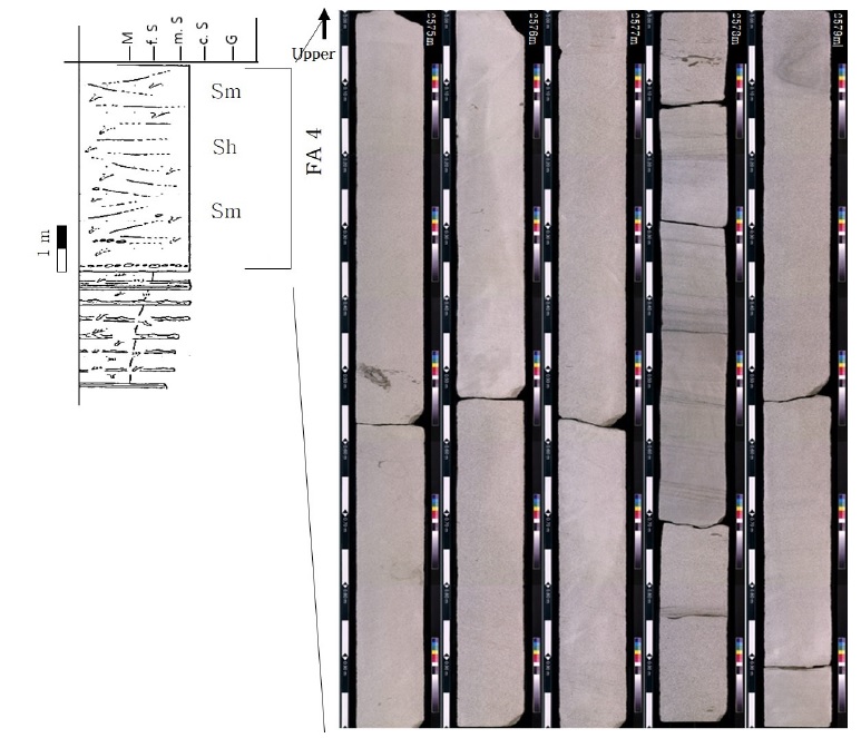
The photograph and representative column type of Facies Association 4 (FA4). This is characterized by massive sandstone (Sm) and faintly laminated sandstone (Sh), interpreted as the distributary mouth bar deposits.
퇴적상조합 5. 내 전면삼각주의 하천 우세 수로(fluvial-dominated channel in the delta front)
퇴적상조합 5는 사층리를 보이는 사암상(Sc)과 수평층리를 보이는 사암상(Sh), 괴상의 사암상(Sm), 역암(G)이 혼재되어 나타난다(그림 18). 퇴적상 Sm이 블록형태로 분포하는 구간은 중립질 사암이나, 퇴적상 C, Sc와 인접한 부분에서 나타나는 퇴적상 Sm은 조립질 사암으로 관찰된다. 사층리와 수평층리를 보이는 사암상 내에서는 나무 파편조각들로 이루어진 고토양 퇴적층이 다수 관찰된다(그림 18). 사층리는 저각에서 고각까지 다양하게 관찰되며, 층리의 방향이 일정하지 않은 것으로 보아 속도의 크기와 방향이 지속적으로 변동하는 유체의 흐름에 의해 형성되었음을 지시한다. 퇴적상조합 5는 다수의 퇴적상이 혼재되어 있지만 그 경계가 뚜렷하지 않고 혼합된 형태를 보이며, 구성 퇴적물은 퇴적상 간의 차이 없이 거의 유사하다. 퇴적상조합 5에서 채취한 사암을 박편상으로 관찰 시, 분급은 양호하며 원마도는 각형에서 아원형으로 해석된다. 암석 전체를 100%로 두었을 때, 그림 19의 A는 석영 65.6%, 장석 8.4%, 암편 1.6%, 이차점토 7.2%, 점토류 4%, 교결물질 5.2%, 육안상 관찰되는 공극률 8%로 이루어져 있으며, 그림 19의 B는 석영 62%, 장석 8.4%, 암편 2%, 이차점토 6.8%, 점토류 5.2%, 교결물질 5.6%, 육안상 관찰되는 공극률 10%로 구성된다. 사암조성은 준장석사암(subarkose)으로 분류된다(Core laboratories Malaysia Sdn Bhd, 1999). 원마도가 각형에서 아각형으로 관찰되며, 광물조성 또한 석영 외 입자들이 다수 포함되어 있는 것으로 보아 조직적으로 성숙하지 않은 것으로 해석된다. 퇴적상조합 5는 침식에 약한 석탄 조각들이 다량 함유되어 있으며, 유체의 흐름이 지속적으로 변동하는 환경 하에 형성된 퇴적상들이 관찰되고 기저면을 침식시키는 흔적들을 고려하여 기원지가 멀지 않은 수로 퇴적물로 해석된다(Fielding et al., 2005; Wei et al., 2016; Zhang et al., 2017). 퇴적률이 높고, 고에너지 환경에서 형성되는 퇴적상들의 조합으로 구성되어 있기 때문에 생물이 거주하기 힘든 환경으로서 생흔 화석을 찾기가 힘들다. 이러한 결과를 종합하여 볼 때, 퇴적상조합 5는 내 전면삼각주 내에 위치한 분류 하도가 교차 이동하며 형성된 퇴적층으로, 육상 하천의 퇴적물 공급이 우세했던 퇴적층으로 해석된다(그림 23, 24).
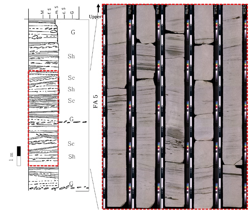
The photograph and representative column type of Facies Association 5 (FA5). This is characterized by horizontal stratified sandstone (Sh), cross-bedded sandstone (Sc) and gravel (G), interpreted as the river-influenced channel deposits.
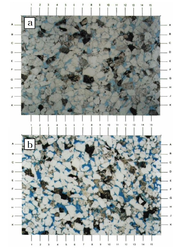
The thin section image of stratified sandstone in FA5. Both thin sections show fair visible porosity(blue-dyed areas). Visible porosity is mainly restricted by compaction, quartz overgrowths, dispersive clay, and authigenic kaolinite. a, 25 magnification view showing mostly medium-grained sandstone (moderately well sorted and massive). Overall visible porosity (blue-dyed areas) is good (8.0%) and most white grains are quartz. b, 25 magnification view showing mostly lower medium-grained sandstone (moderately to well sorted). Visible porosity is good (10.0%). Note large dissolution porosity (G12.1, GH4.5, and H6.6) formed from feldspar leaching. Grid Reference Increment Length (A-B, 1-2, etc) - 0.28 mm.
퇴적상조합 6. 내 전면삼각주의 조간대 환경(intertidal environment of the inner delta front)
퇴적상조합 6은 부유식 침전을 통해 퇴적된 이암과 사암이 교호하는 퇴적상 MS와 엽층리, 수평층리, 사층리를 보이는 사암상인 Sl, Sh, Sc 그리고 층리를 이루는 역암상 G로 구성되어 있다(그림 20). 최하부는 조립질 입자의 사층리를 보이는 사암상(Sc)과 일부 역을 포함하는 층(G)이 관찰되며, 이는 조간대 수로 기저부를 지시한다(Dalrymple, 2010). 하부에는 저조선 부근에서 나타나는 이질층이 거의 없는 맥상층리가 관찰되며, 중간 부분은 파상층리, 최상부는 고조선 일대에서 나타나는 렌즈상층리가 관찰되는 점이적인 변화를 보인다(그림 20). 이들은 조간대 환경에서 나타나는 전형적인 퇴적구조들이다. 최하부에서는 조립질 사암과 함께 패각편 및 자갈들로 이루어진 암설이 약 30 cm 가량 나타나는데, 해당 구간은 저조선 경계로 파도 에너지가 가장 강하게 작용한다(Dalrymple et al., 2010). 일반적으로 조수차가 큰 지역은 외해 방향으로 나아갈수록 파도 에너지가 강해지는데 이는 정상 조수 프리즘의 결과로 조류가 약하게 작용하기 때문이다(Yang et al., 2007). 이 외에도 렌즈상 층리가 관찰되는 상부 구간에서는 시너리시스 크랙이 다수 관찰된다. 시너리시스 크랙은 지표에 노출되지 않은 상태인 수중환경에서 퇴적물 밖과 퇴적물 내에 포함된 물의 염도 차이에 의해 퇴적물 내의 물이 빠져나간 구조로서, 해수와 담수가 반복적으로 흐르면서 생긴 구조로 해석할 수 있다. 중간부에 나타나는 파랑연흔 역시 다른 퇴적상에서 나타나는 것에 비해 불규칙적이고 다양한 크기와 모양을 보여주는데, 이것은 조간대 지역의 수심이 수시로 변하고 조류 방향이 일정하지 않기 때문이다(Collinson et al., 2006). 퇴적상조합 6은 사암이 우세한 구간에서는 생흔화석이 관찰되지 않으나, 파랑 연흔이나 고조선 구간에서는 Fugichnia와 Burgaueria, Thalassinoides 같이 조간대 환경을 지시하는 거주구조(dwelling trace)가 관찰된다(Ksiazkiewicz, 1977; Swinbanks and Luternauer, 1977; MacEachern et al., 2010). 앞서 관찰된 암상, 퇴적구조 및 생흔상을 종합해 볼 때 퇴적상조합 6은 내 전면삼각주 내 고조선과 저조선 사이 구간을 포함한 조간대 퇴적층으로 해석된다(그림 23, 24).
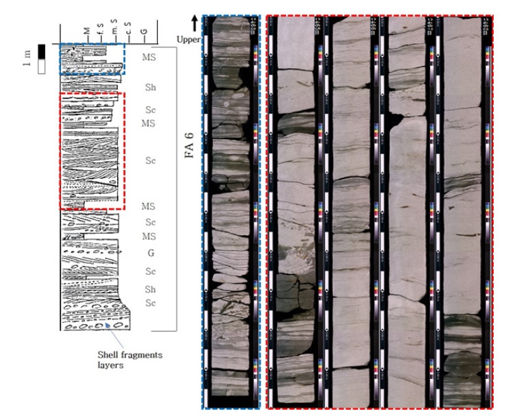
The photograph and representative column type of Facies Association 6 (FA6). This is characterized by alternating thin mudstone and sandstone (MS), interpreted as the intertidal deposits.
퇴적상조합 7. 내 전면삼각주의 조석 우세 수로(tide-dominated channel in the inner delta front)
퇴적상조합 7은 파랑연흔을 포함하는 사암과 이암이 교호하는 퇴적상 MS와 사층리를 보이는 사암상 Sc, 수평층리를 보이는 사암상 Sh, 역암상, G가 혼재되어 나타난다. 사층리는 저각에서 고각까지 다양하게 관찰되며, 층리의 방향이 일정하지 않다(그림 21). 이는 유체 속도의 크기와 방향이 지속적으로 변동하는 흐름에 의해 형성되었음을 지시한다. 파랑 연흔을 보이는 구간과 인접하여 곡형사층리가 관찰되는데 이는 판상사층리보다 유속이 빠른 환경에서 발생한다(Collinson et al., 2006). 사층리 또는 수평층리 내에서 이암편과 석탄 조각들이 관찰되며, 드물게 조개 파편들이 층리를 이루고 있다(그림 22a, 22b). 퇴적상 MS 내 이암 상부 면에서는 물리 화학적으로 불안정한 환경을 피해 하부 퇴적층으로 이동하는 탈출 구조(fugichnia) 흔적 화석이 다수 확인되며, 해수와 담수의 반복적인 흐름에 의해 염도 차이가 발생하여 퇴적물 내에 포함되어있던 물이 빠져나가면서 형성된 시너리시스 크랙이 관찰된다(그림 22c). 퇴적상조합 7에서는 석탄 조각을 다량 포함하고 있으며, 층리의 경사와 방향이 수시로 바뀌는 것을 보아 퇴적상조합 5와 유사한 육상으로부터 연결된 분류하도 퇴적층으로 해석할 수 있다. 다만, 퇴적상조합 5에 비해 이암 층리가 빈번하게 나타나며, 조간대 환경을 지시하는 시너리시스 크랙 퇴적구조와 Bergaueria 거주구조가 관찰되는 것으로 보아 퇴적상조합 7은 조간대 환경 내 위치한 조간대 수로 퇴적층으로 해석된다.
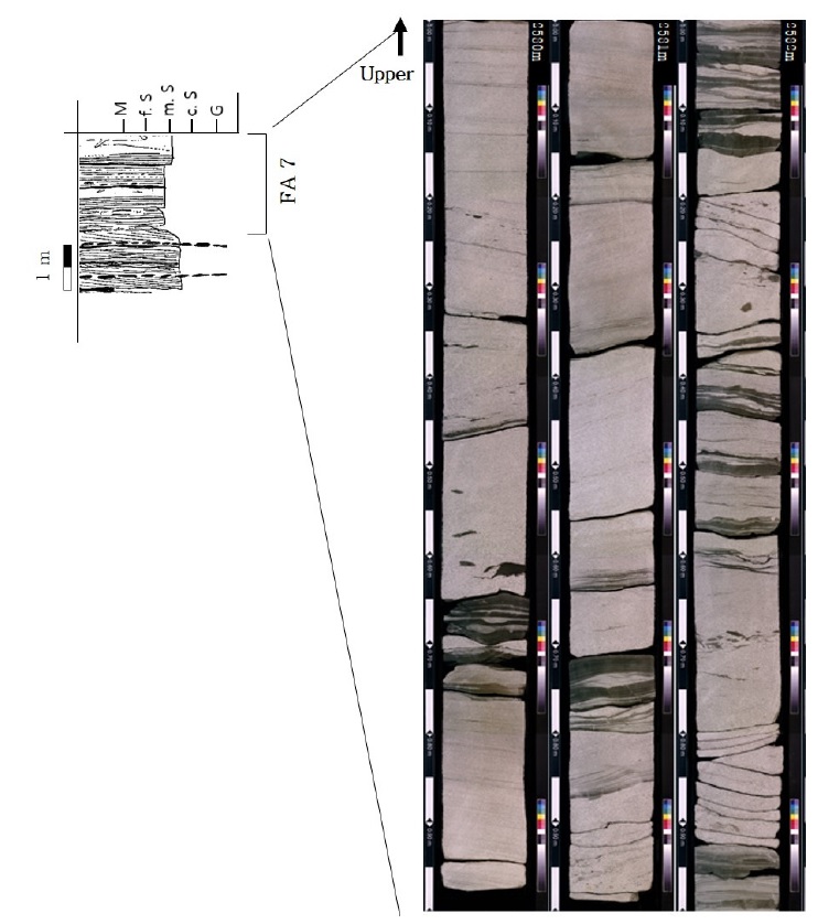
The photograph and representative column type of Facies Association 7 (FA7). This is characterized by alternating thin mudstone and sandstone (MS) with wave ripples, interpreted as the tide-influenced channel deposits.
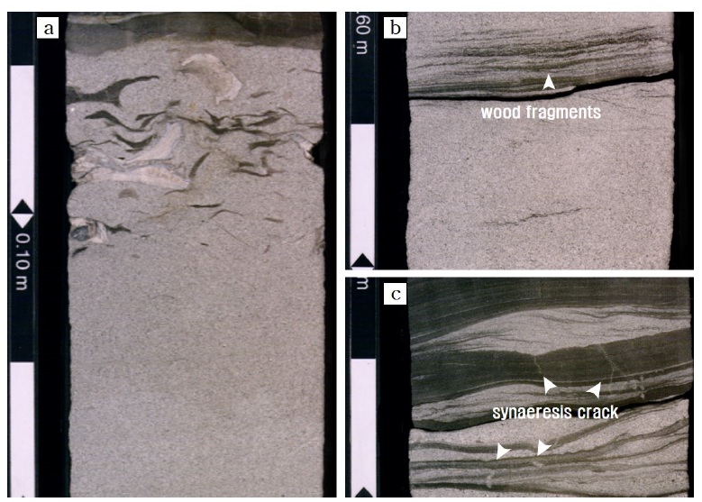
The photographs of sedimentary structures from facies association 7. a, Disrupted wave ripples, characteristic features of a swash bar. It is redistributed along the middle shoreface to the upper shoreface by strong currents. Cross-bedded gravels include shell fragments and coals. b, Low-angle cross-bed commonly consisting of wood fragments. c, Wave ripples and syneresis cracks.
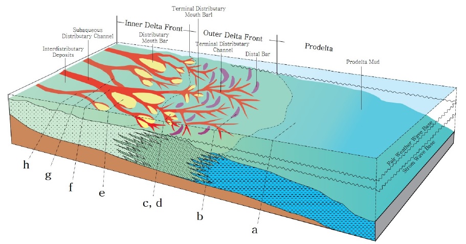
The schematic diagram showing the depositional model for the deltaic environment of the upper middle Miocene sediment in Ulleung Basin, Korea (modified after Li et al., 2017). (a) Facies Association 1; (b) Facies Association 2; (c), (d) Facies Association 3; (e) Facies Association 4; (f) Facies Association 5; (g) Facies Association 6; (h) Facies Association 7.
5. 토 의
앞서 해석된 퇴적상 분류 및 퇴적상 조합의 해석을 종합하면, Well #1, Well #2 시추공 내에서 확인된 울릉분지 남서부에 위치한 중기 마이오세 저류층은 삼각주 환경 내 7가지 세부 퇴적환경에서 형성된 것으로 추정된다. 두꺼운 사암층의 생성환경은 전면삼각주 최상부에 위치한 하천 우세 수로, 조석 우세 수로, 삼각주 전면부로 분류되는데, 삼각주 전면부는 다시 물리적으로 불안정한 상태로서 생흔화석이 거의 관찰되지 않는 근위부에 위치한 하구사주 환경과 퇴적물 집적률이 낮아 생흔 화석의 밀도가 높은 분류하도 말단부에 위치한 하구사주 환경으로 구분된다.
Well #1공의 시추코어 구간에서 관찰되는 두꺼운 사암층은 전면삼각주 최상부에 위치한 하천 우세 수로, 조석 우세 수로, 근위부에 위치한 하구사주, 분류하도 말단부에 위치한 하구사주 퇴적층으로 해석되고, Well #2공에서 관찰되는 두꺼운 사암층은 근위부에 위치한 하구사주 퇴적층, 분류하도 말단부에 위치한 하구사주 퇴적층으로 구분된다. Well #1에서 관찰되는 전면삼각주 최상부에 위치한 하천 우세 수로는 multi-stacked channel 형태를 보이는데, 이는 분기하는 분류 수로가 측방 이동하며(switching) 퇴적물이 수직적으로 증착되면 형성한 것으로 해석된다. Multi-stacked channel이 형성되는 환경은 퇴적률이 높고 침강속도 및 다짐작용 또한 퇴적률에 비례하여 높다(Darlymple et al., 2010). 전면삼각주 최상부에 위치한 하천 우세 수로 퇴적층은 연구 구간에서 관찰되는 환경 중 가장 높은 조직 성숙도를 보인다.
삼각주 전면부는 미교란 퇴적층이 분포하는 근위부 하구사주 환경과 생교란 퇴적층이 분포하는 말단부 하구사주 환경으로 구분되는데, Well #1공 시추코어 내 생교란 퇴적층의 BI(bioturbation index)는 4-5로 생흔화석의 밀도가 높다(그림 24). Well #2공 시추코어에서 관찰되는생교란 퇴적층의 BI는 2-3으로 Well #1공의 생교란 퇴적층에 비해 생흔화석의 밀도가 낮다(그림 24). 생물 교란과 생물 교란에 의해 변형된 조직은 퇴적 직후 초기 속성과정에서 중요하게 발생하는데, 퇴적 조직이나 퇴적구조를 쉽게 변형시키거나 생물이 퇴적층을 굴착할 때 거주 구조의 무너짐을 방지하기 위해 점착성 있는 물질로 내벽(lining)을 형성하여 퇴적층의 공극률을 증가 또는 감소시키기도 한다(Knaust, 2017).
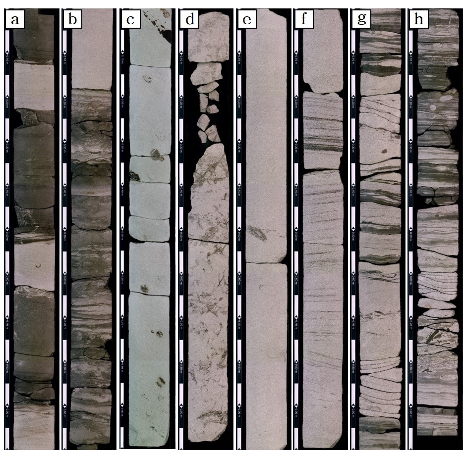
The selected core photographs showing the representative facies association in the upper Middle Miocene sediments. (a) Prodelta mud; (b) Distal bar; (c) Terminal distributary mouth bar. BI 2-3; (d) Terminal distributary mouth bar. BI 4-5; (e) Distributary mouth bar; (f) Subaqeuous distributary channel (river-influenced deposits); (g) Subaqeuous distributary channel (tide-influenced deposits); (h) Intertidal zone.
기존 물리탐사 자료에 의존한 모델링은 시추코어 자료를 활용한 것에 비해 퇴적상을 세부적으로 구분하기 어렵기 때문에 유사 환경으로 크게 그룹화할 수밖에 없다. 반면 시추코어를 활용한 연구를 통해 도출한 퇴적상 정보를 입력자료로 활용하면 보다 세밀한 퇴적상 모델(fine model)을 구현할 수 있다. 세밀한 모델은 석유 매장량 산정과 유체 유동 특성을 정확하게 모사하는데 도움이 될 수 있고 특히, 저류층 모델링을 통한 저류암 품질 분석에서 유용하게 활용될 수 있을 것이다.
이번 연구에서는 두 공의 탐사정에서 취득한 시추코어를 바탕으로 퇴적환경을 해석함으로써 탄성파 탐사자료나 물리검층 자료로 환경을 해석한 것에 비해 보다 세부적인 퇴적환경으로 구분할 수 있었다. 하지만 넓은 면적의 노두가 아닌 지름 3인치의 코어 단면에서 관찰되는 퇴적물 조직과 퇴적구조, 그리고 이를 바탕으로 한 퇴적상 분석만으로 퇴적환경을 해석하는데는 한계가 있기 때문에 이를 보완하기 위해 흔적 화석의 종류와 생물 교란의 정도가 지시하는 환경을 통합하여 해석하였다. 다만, 생흔 교란 지수가 낮은 경우 얻을 수 있는 정보가 많지 않았다. 그리고 앞서 해석된 것처럼 Well #1공 퇴적층에서는 내 전면삼각주 환경에서 전위삼각주 전면부 환경에서 형성된 사질 퇴적층이 관찰되나, Well #2공에서는 외 전면삼각주 환경과 전위삼각주 전면부 환경에서 형성된 퇴적층만 관찰된다. 때문에 두 시추공에서 겹치는 블록형 사암층 구간은 외 전면삼각주에 위치한 분류하도 말단부 하구사주에서 형성된 퇴적층과 말단사주에서 형성된 퇴적층만으로 구성되어 있다. 따라서, 추후 인근에 위치한 시추공으로부터 추가로 획득된 시추코어를 활용하여 연구를 확대할 수 있다면 보다 신뢰도 높은 퇴적환경 해석을 실시할 수 있을 것으로 기대된다.
6. 결 론
울릉분지 남서부에 위치한 중기 마이오세 저류층 구간의 세부적인 퇴적환경 해석과 각 환경에 따른 저류층 품질을 분석하기 위해 탐사정으로부터 취득한 시추코어를 활용하여 퇴적상 분류, 퇴적상·생흔상 조합, 저류층 물성값 분석을 수행하였다. 연구에 대한 결론은 다음과 같다.
1) 2공의 탐사정으로부터 취득된 각 80 m에 이르는 시추코어는 암상, 퇴적구조, 조직, 입도, 생흔화석의 종류 및 밀집도 관찰 결과를 통해 9개의 퇴적상으로 분류하였으며(표 1), 분류된 퇴적상 간의 경계면의 특징, 반복적인 산출 정도를 고려하여 7개의 퇴적상조합을 설정하였다.
2) 시추코어에서 관찰된 중기 마이오세 저류층 구간은 전위삼각주, 외 전면삼각주, 내 전면삼각주 환경에서 형성된 7개의 세부 퇴적층으로 해석된다.
① 전위삼각주 환경에서는 저에너지 환경에서 형성된 이질 퇴적상(Ml, Mm)사이에 세립질의 사암상(Sm, Sh, Sc)이 협재되어 있는 전위삼각주 이암 퇴적층이 관찰된다. 이질층에서 드물게 수평 생흔구조인 nereites가 관찰되는데, 이러한 생흔상은 퇴적 특성과 일치한다.
② 외 전면삼각주 환경에서는 말단사주 퇴적층과 분류하도 말단부에 위치한 하구사주 퇴적층이 분포한다. 말단사주 퇴적층은 외곽부의 해저 선상지 퇴적물이 재동되어 형성된 이암과 사암이 교호하는 퇴적상(MS)과 분류하도로부터 불규칙적으로 공급된 세립질의 사암상(Sm, Sh)가 협재되어 있는 양상을 보인다. 이질층에서는 외해 전이대 환경을 지시하는 Cruziana ichnofacies가 관찰된다. 분류하도 말단부에 위치한 하구사주 퇴적층은 생물 교란을 받은 사암상(Sm-b)과 세립질 사암상(Sm, Sh, Sc)가 협재되어 있는 양상을 보인다. 생물 교란 퇴적층에서는 고에너지 환경을 지시하며, 중부-하부 해안전면부에서 잘 나타나는 Skolithos ichnofacies 연속적으로 관찰되는데, 빈번한 생물활동의 흔적과 구조의 보존은 낮은 퇴적률과 비교적 안정적인 환경이 지속되었었음을 지시한다.
③ 내 전면삼각주 환경에서는 근위에 위치한 하구사주 퇴적층, 조간대 퇴적층, 분류하도 퇴적층이 분포한다. 근위에 위치한 하구사주 퇴적층은 분급이 매우 양호한 중·조립질 사암상(Sm, Sh)으로 이루어진 순수 사질 퇴적물로 미량의 나무 파편 조각과 패각편을 포함하고 있다. 생흔화석은 거의 나타나지 않으나, 극히 드물게 천해성 사암 환경을 지시하는 Ophiomorpha, Skolithos가 관찰된다. 이는 높은 퇴적률과 다짐작용으로 인해 시각적으로 인지되는 생흔 화석의 발달이 미약한 것으로 해석된다. 조간대 퇴적층은 엽층리를 보이는 사암상(Sl)과 중립질 사암상(Sm, Sc)으로 구성되어 있다. 사질층이 우세한 저조선에서 이질층이 우세한 고조선 구간이 전반적으로 나타나며 조간대 수로 퇴적층도 관찰된다. 이암층에서는 Burgaueria, Thalassinoides 같이 조간대 환경을 지시하는 거주구조가 관찰된다. 분류하도 퇴적층은 층리의 경사와 방향이 지속적으로 변하는 유체에 의해 형성된 중·조립질사암상(Sc, Sh)과 수로의 기저부를 나타내는 역암층(G)으로 이루어져 있으며, 침식에 약한 나무파편조각, 탄층이 다량 포함된다. 생흔 화석은 전혀 관찰되지 않는다. 이는 높은 퇴적률로 인해 생물이 거주할 수 있는 능력이 제한되었음으로 해석된다. 분류하도 퇴적층은 전면삼각주 최상부에 위치한 수로 퇴적층과 조간대 수로 퇴적층으로 구분된다. 두 퇴적층을 이루고 있는 퇴적물과 암상 구조 등은 유사하나, 조간대 수로 퇴적층에서는 수 cm 두께의 이암 층리와 함께 관찰되는 파랑구조가 특징적이며, 조간대 환경을 지시하는 퇴적구조 및 생흔화석이 다수 관찰되는 점에서 차이가 있다.
Acknowledgments
이 논문의 심사과정을 통해 유익하고 세밀한 수정 의견을 주신 심사위원들과 편집위원께 감사드립니다.
References
-
Allen, J.R.L. and Friend, P.F., 1976, Changes in intertidal dunes during two spring-neap cycles, Lifeboat Station Bank, Wells next the Sea, Norfolk (England). Sedimentology, 23, 329-346.
[https://doi.org/10.1111/j.1365-3091.1976.tb00053.x]

- Chough, S.K., 1983, Marine Geology of Korean Seas. International Human Resources Development Corp., Boston, 157 p.
-
Chough, S.K. and Barg, E., 1987, Tectonic history of Ulleung basin margin, East Sea (Sea of Japan). Geology, 15, 45-48.
[https://doi.org/10.1130/0091-7613(1987)15<45:THOUBM>2.0.CO;2]

-
Chough, S.K., Lee, H.J. and Yoon, S.H., 2000, Marine geology of Korean seas. Elsevier, 313 p.
[https://doi.org/10.1016/B978-044450438-8/50016-3]

-
Chough, S.K., Lee, S.H., Kim, J.W., Park, S.C., Yoo, D.G., Han, H.S., Yoon, S.H., Oh, S.B., Kim, Y.B. and Back, G.G., 1997a, Chirp (2-7 kHz) echo characters in the Ulleung Basin. Geoscience Journal, 1, 143-154.
[https://doi.org/10.1007/BF02910206]

-
Chough, S.K., Yoon, S.H. and Park, S.J., 1997b, Stratal paterns in the southwesternmargin of the Ulleung Basin of southeast Korea: sequence architecture controlled by back-arc tectonism. Geo-Marine Letters, 17, 207-212.
[https://doi.org/10.1007/s003670050028]

- Collinson, J.D., Mountney, N.P. and Thompson, D.B., 2006, Depositional structures of sands and sandstones. In: Collinson, J.D., Mountney, N.P., Thompson, D.B., (eds.), Sedimentary structures, Terra Publishing, 74-132.
- Core Laboratories Malaysia Sdn Bhd, 1999, Petrophysical properties report volume I part 2 for well : Gorae V-1. 861 p.
- Dalrymple, R.W., 2010, Tidal depositional system. In: James, N.P. and Dalrymple, R.W., (eds.), Facies Models, 4, Geo-text 6, Geological Association of Canada, 201-232.
-
Fielding, C.R., Trueman, J.D. and Alexander, J., 2005, Sharp-based flood-dominated mouth bar sands from the Burdekin River delta of northeastern Australia: extending the spectrum of mouth-bar facies, geometry and stacking patterns. Journal of Sedimentary Research, 75, 55-66.
[https://doi.org/10.2110/jsr.2005.006]

-
Hampson, G.J. and Howell, J.A., 2017, Sedimentologic and sequence-stratigraphic characteristics of wave-dominated deltas. AAPG Bulletin, 101, 441-451.
[https://doi.org/10.1306/011817DIG17023]

- Ingle Jr, J.C., 1992, Subsidence of the Japan Sea: Stratigraphic evidence from ODP sites and onshore sections. Proceedings of the Ocean Drilling Program, Scientific Results, 127-128, 1190-1218.
- Jolivet, L. and Tamaki, K., 1992, Neogene kinematics in the Japan Sea region and volcanic activity of the Northeast Japan Arc. Proceedings of the Ocean Drilling Program, Scientific Results, 127, 1311-1331.
-
Kang, D.H., Chun, J.H., Koo, N.H., Kim, W.S. and Lee, H.Y., 2015, Consideration on the gas and gas hydrate indicators in seismic profiles based on drilling result from the Ulleung Basin, East Sea. Journal of the Geological Society of Korea, 51, 561-568 (in Korean with English abstract).
[https://doi.org/10.14770/jgsk.2015.51.6.561]

-
Kim, W.S., Cheong, D.K. and Kendall, C.G.S.C., 2007, Effects of in-phase and out-of-phase sediment supply responses to tectonic movement on the sequence development in the late Tertiary Southern Ulleung Basin, East (Japan) Sea. Computers & Geosciences, 33, 299-310.
[https://doi.org/10.1016/j.cageo.2006.08.001]

-
Knaust, D., 2017a, Classification of Burrows. In: Knaust, D. (ed.), Atlas of Trace Fossils in Well Core, Springer, 288 p.
[https://doi.org/10.1007/978-3-319-49837-9]

-
Knaust, D., 2017b, Diffuse Bioturbate Texture. In: Knaust., D. (ed.), Atlas of Trace Fossils in Well Core, Springer, 177 p.
[https://doi.org/10.1007/978-3-319-49837-9]

-
Knaust, D., 2017c, Reservoir Quality. In: Knaust, D. (ed.), Atlas of Trace Fossils in Well Core, Springer, 141 p.
[https://doi.org/10.1007/978-3-319-49837-9]

- KNOC, 2014, Technical evaluation report for domestic continental shelfs, 129 p (in Korean).
- Ksiazkiewicz, M., 1977, Trace fossils in the flysch of the Polish Carpathians. Palaeontologia Polonica, 36, 633-646.
-
Lee, B.K. and Kim, S.Y., 2007, Sedimentary facies and processes in the Ulleung Basin and Southern East Sea. Korean Journal of Fisheries and Aquatic Sciences, 40, 160-166.
[https://doi.org/10.5657/kfas.2007.40.3.160]

-
Lee, G.H., Kim, B., Chang, S.J., Huh, S. and Kim, H.J., 2004, Timing of trap formation in the southwestern margin of the Ulleung Basin, East sea (Japan Sea) and implications for hydrocarbon accumulations. Geosciences Journal, 8, 369-380.
[https://doi.org/10.1007/BF02910473]

-
Lee, G.H., Kim, H.J., Han, S.J. and Kim, D.C., 2001, Seismic stratigraphy of the deep Ulleung Basin in the East Sea (Japan Sea) back-arc basin. Marine and Petroleum Geology, 18, 615-634.
[https://doi.org/10.1016/S0264-8172(01)00016-2]

-
Lee, G.H., Yoon, Y., Nam, B.H., Lim, H., Kim, Y.S., Kim, H.J. and Lee, K., 2011, Structural evolution of the southwestern margin of the Ulleung Basin, East Sea (Japan Sea) and tectonic implications. Tectonophysics, 502, 293-307.
[https://doi.org/10.1016/j.tecto.2011.01.015]

-
Li, S., Ma, Y.Z., Yu, X. and Li, S., 2017, Reservoir potential of deep-water lacustrine delta-front sandstones in the Upper Traiassic Yanchang formation, Western Ordos Basin, China. Journal of Sedimentary Petrology, 40, 105-118.
[https://doi.org/10.1111/jpg.12666]

- MacEachern, J.A., Pemberton, S.G., Gingras, M.K. and Bann, K.L., 2010, Ichnology and facies models. In: James, N.P. and Dalrymple, R.W. (eds.), Facies Models 4, Geo-text 6, Geological Association of Canada, 4, 19-58.
-
Okoro, A.U. and Igwe, E.O., 2014, Lithofacies and depositional environment of the Amasiri Sandstone, southern Benue Trough, Nigeria. Journal of African Earth Sciences, 100, 179-190.
[https://doi.org/10.1016/j.jafrearsci.2014.05.009]

- Park, D.B., Park, S.J., Yoo, C.S. and Jang, H.R., 1995, Geologic structure and stratigraphic correlation of Gorae and Dolgorae areas. KNOC, 60 p (in Korean).
- Park, K.S., 1992, Geologic structure and seismic stratigraphy of the southern part of Ulleung Basin. In: Chough, S.K. (eds.), Sedimentary Basins in the Korean Peninsula and Adjacent Seas. Sedimentary Geology, Korean Sedimentology Research Group Special Publication, 86, 40-59.
- Plint, A.G., 2010, Wave- and storm-dominated shoreline and shallow-marine systems. In: James, N.P. and Dalrymple, R.W. (eds.), Facies Models, 4, Geo-text 6, Geological Association of Canada, 167-200.
-
Swinbanks, D.D. and Luternauer, J.L., 1977, Burrow distribution of thalassinidean shrimp on a Fraser Delta intertidal, British Columbia. Journal of Paleontology, 61, 315-332.
[https://doi.org/10.1017/S0022336000028493]

- Tamaki, K., Suyehiro, K., Allan, J., Ingle Jr, J.C. and Pisciootto, K.A., 1992, Tectonic synthesis and implications of Japan Sea ODP drilling. In: Tamaki, K., Suyehiro, K., Allan, J., and McWilliams, M. (eds.), Proceedings of ODP Scientific Results, 127/128, Scientific Results. Texas: Ocean Drilling Program, College Station, 1333-1348.
-
Wei, X., Steel, R.J., Ravnas, R., Jiang, Z., Olariu, C. and Li, Z., 2016, Variability of tidal signals in the brent delta front: New observations on the rannoch formation, northern North sea. Sediment. Sedimentary Geology, 335, 166-179.
[https://doi.org/10.1016/j.sedgeo.2016.02.012]

-
Yang, B.C., Dalrymple, R.W., Gingras, M.K., Chun, S.S. and Lee, H.J., 2007, Up-estuary variation of sedimentary facies and ichnocoenoses in an open-mouthed, macrotidal, mixed-energy estuary, Gomso Bay, Korea. Journal of Sedimentary Research, 77, 757-771.
[https://doi.org/10.2110/jsr.2007.073]

-
Yang, B.C., Paik, S., Choi, Y.S. and Dalrymple, R.W., 2019, Sedimentology of a wave-dominated and tide-influenced deltaic systemm upper Middle Miocenem southwestern Ulleung Basin, Korea. Marine and Petroleum Geology, 101, 78-89.
[https://doi.org/10.1016/j.marpetgeo.2018.11.045]

-
Yoo, D.G., Kim, S.P., Lee, C.W. and Park, S.C., 2011, Seiscim stratigraphy and depositional history of Holocene Transgressive deposits in the southeastern continental shelf, Korea. The Korean Society of Economic and Environmental Geology, 44, 303-312 (in Korean with English abstract).
[https://doi.org/10.9719/EEG.2011.44.4.303]

-
Yoon, H.H. and Chun, S.S., 2019, Rapid shift of surface sedimentary facies and its depositional mechanism in the macrotidal wave-dominated Sinduri Bay, west coast of Korea. Journal of the Geological Society of Korea, 55, 257-276 (in Korean with English abstract).
[https://doi.org/10.14770/jgsk.2019.55.3.257]

-
Yoon, S.H. and Chough, S.K., 1995, Regional strike slip in the eastern continental margin of Korea and its tectonic implications for the evolution of Ulleung Basin, East Sea (Sea of Japan). Geological Society of America Bulletin, 107, 83-97.
[https://doi.org/10.1130/0016-7606(1995)107<0083:RSSITE>2.3.CO;2]

-
Yoon, S.H., Cough, S.K. and Park, S.J., 2003, Sequence model and its application to a Miocene shelf-slope system in the tectonically active Ulleung Basin margin, East Sea (Sea of Japan). Marine and Petroleum Geology, 20, 1089-1103.
[https://doi.org/10.1016/j.marpetgeo.2003.08.001]

-
Yoon, S.H., Park, S.K. and Chough, S.K., 2002, Evolution of sedimentary basin in the southwestern Ulleung Basin margin: Sequence stratigraphy and geologic structures. Geosciences Journal, 6, 149-159.
[https://doi.org/10.1007/BF03028286]

- Yun, H.S. and Yi, S.S., 2002, Biostratigraphy and paleoceanography for the Gorae and Dolgorae Wells, offshore Korea, and their implications to Neogene tectonic history. In: Tateishi, M., and Kurita, H. (eds.), Development of Tertriary Sedimentary Basins Around Japan Sea (East Sea), Niigata University, 20, 65-78.
-
Zhang, X., Dalrymple, R.W. and Lin, C.M., 2017, Facies and stratigraphic architecture of the late Pleistocene to early Holocene tide-dominated paleo-Changjiang (Yangtze River) delta. GSA Bulletin, 130, 455-483.
[https://doi.org/10.1130/B31663.1]


