전라남도 시도기념물 제24호 화순 백아산 자연동굴의 동굴지질학적 특징 및 형성과정
초록
이 연구에서는 전남 화순군 시도기념물 제24호 화순 백아산 자연동굴(백아산동굴)의 동굴지질학적 분석을 통해 변성퇴적암류에서의 용해동굴 형성과정 및 요인에 대한 개념적 모델을 제시하였다. 백아산동굴은 전체적으로 장축이 수 미터에서 최대 10여 m에 이르는 작은 동방 3개와 이들을 이어주는 비교적 협소한 통로들로 구성되어 있다. 이 연구의 일환으로 작성된 동굴도면(cave map)과 내부조사 결과를 함께 고려하면 백아산동굴은 최소 3갈래 이상의 가지굴을 포함하는 미성숙 가지형 동굴(rudimentary branchwork cave)로 분류할 수 있다. 백아산동굴 내부에서 관찰되는 통로 횡단면 형태, 동굴미지형(speleogen) 및 퇴적물의 특징과 분포를 토대로 해석한 형성 구간은 전체 조사길이 대비 포화대 5.1%, 포화대 내지 상부포화대 8.2%, 상부포화대 11.2%, 상부포화대 내지 통기대 48.4% 및 통기대 27.0%로 나타났다. 동굴지질학적 분석결과를 통해 추정한 백아산동굴의 형성 단계는 1) 포화대-상부포화대 미소규모 독립 공동 형성단계, 2) 상부포화대 공동 연결 단계, 3) 상부포화대-통기대 최대 확장 단계 4) 통기대 추가 확장 단계, 5) 현재 최심부 연장 단계로 요약된다. 결론적으로, 백아산동굴의 형성은 탄산염암 지층과 이질암층이 교호하는 변성퇴적암류에서 용해 동굴이 형성되는 모델을 제시해주고 있다. 특히, 이번 연구의 결과는 통로의 확장 및 동굴의 진화가 지하수면 하강과 밀접하게 연관되어 있음을 확인시켜주며, 포화대 내에서 소규모의 초기 공동이 발달한 후 통로의 상호 연결에 의해 다양한 유형의 동굴미지형과 동저 퇴적물이 형성되는 일련의 동굴형성과정(speleogenesis)을 제시한다.
Abstract
This study aims to present a conceptual model for the formation of the solution cave in metasedimentary rocks by analyzing speleological characteristics of Baek-ah-san cave (Provincial monument No. 24) in Hwasun-gun, Jeollanam-do, Korea. Baek-ah-san cave is mainly composed of three cave rooms, which are several meters in length, and interconnecting narrow passages between the rooms. In the plan view, this cave shows a single main passage with several immature branches and can be classified to a rudimentary branchwork cave with at least 3 branching short passages. Based on speleological analyses related to cross sections of the passage, speleogens and cave sediments, we estimated that about 48.4% of total investigated passage length was evolved in epiphreatic to vadose condition. Also, ~5.1, 8.2, 11.2 and 27.0% of total had been developed at phreatic, phreatic to epiphreatic, epiphreatic and vadose settings, respectively. Five stages on the evolution of Baek-ah-san cave have been detected from speleological evidences as follows: 1) the initial stage of non-interconnecting cavities in the phreatic to epiphreatic zone, 2) the interconnecting stage for phreatic to epiphreatic cavities, 3) the maximum enlargement stage in the epiphreatic to vadose zone 4) the additional extension stage at the vadose zone, 5) the stage of extension into the deepest area. In conclusion, our results provide a typical conceptual model for solution caves developed in metasedimentary rocks alternating recrystallized limestone and highly fissile shale beds. The results from Baek-ah-san cave suggest that relatively small-scale initial cavities of this cave had been evolved to an interconnecting cave system with various types of speleogens and cave sediments by the long-term falling of water table and bedrock disintegrations by slate layers.
Keywords:
Baek-ah-san cave, speleogenesis, water table, cave, karst키워드:
화순 백아산 자연동굴, 동굴형성과정, 지하수면, 동굴, 카르스트1. 서 론
동굴은 일반적으로 지하에 자연적으로 형성된 공동으로서, 그 범위를 사람의 출입이 가능한 크기 이상으로 제한할 수 있다(e.g., White, 1988; Gunn, 2004; Palmer, 2007). 하지만 이러한 동굴의 정의는 학자에 따라 견해를 달리하기도 하는데, Palmer (2007)는 동굴은 영구적인 암흑구간(total darkness)을 포함하고 있어야 한다는 점을 강조하였고, Won (2000)의 경우 사람의 출입이 어렵더라도 연장 가능성이 충분히 있는 것도 동굴에 포함시켜야 한다고 언급하였다. Woo and Kim (2004)은 총 길이가 5 m 이상이거나 주요 통로(주굴)의 길이가 입구의 폭과 높이 중 장축보다 긴 경우를 동굴로 정의하고 동굴생성물이 분포하는 경우는 예외적으로 3 m 이상부터 동굴로 정의하기도 하였다. 또한, 이들은 사람이 출입할 수 없는 경우에도 연장가능성이 충분하다고 평가될 때 천연동굴로 포함하였다(Woo, 2005).
대분류에 의한 동굴의 종류는 지질작용에 따라 구분할 수 있는데, 일반적으로 용해 동굴(solution caves), 화산 동굴(volcanic caves), 빙하 동굴(glacier caves), 절리 동굴(crevice caves), 침식 동굴(erosion caves), 테일러스 동굴(talus caves), 틀구조 동굴(framework caves) 등으로 나눌 수 있다(e.g., Gunn, 2004; Palmer, 2007). 국내에는 많은 수의 용해 동굴, 화산 동굴, 침식 동굴이 알려져 있지만 아직까지 각 동굴 별로 세부적인 형성 원인을 밝히는 연구는 극히 미흡한 상태이다. 강원도 동남부 지역의 고생대 석회암에 분포하는 수많은 용해 동굴 중 옥계굴과 제주도에 분포하는 화산 동굴인 만장굴에 한하여 형성 원인이 언급된 바 있다(Choi et al., 2003; Ahn and Hwang, 2008).
전 세계적으로 그 수가 압도적으로 많은 용해 동굴의 형성 원인을 밝히기 위해서는 다양한 지질학적 접근법이 필요한데, 세부적인 동굴형성과정(speleogenesis) 연구를 위해서는 동굴환경에 적합한 종합적 분석이 필수적이다. 이는 동굴 내부에 발달하고 있는 동굴미지형(speleogen), 동굴퇴적물, 암석학적 및 구조지질학적 특징 등이 동굴통로 형성의 선후관계, 형성 조건 및 고수리학적(paleo-hydrological) 특성을 지시할 수 있기 때문이다. 동굴형성과정연구 분야는 제4기 지질학, 수리지질학, 퇴적암석학 분야 등 순수 지질학적인 측면 뿐 만 아니라, 석유저류시스템, 지질재해 및 지질유산 관련 응용 측면에서도 그 필요성이 매우 높다.
1979년 전라남도 시도기념물 제24호로 지정된 화순 백아산 자연동굴(백아산동굴)은 전라남도에 위치한 유일한 동굴로 언급된 바 있으며(Ahn et al., 2014), 현재까지 문화재로 지정된 용해 동굴로는 국내 최남단에 위치해 있다. 최근 백아산 자연동굴(백아산동굴) 내부에 존재하는 동굴생성물(동굴산호와 붕암) 및 주변 이질퇴적물의 광물학적 특성을 확인하고, 동굴생성물 내에 서식하는 호기성미생물을 농화 배양하여 탄산염광물 형성을 위한 생광물화작용에 대한 연구가 수행되었다(Kim et al., 2018). 이번 연구의 목적은 지리적 분포 측면에서 희소성을 지니는 백아산동굴의 동굴지질학적 특징을 보고하고 변성퇴적암류(metasedimentary rocks) 기반 용해 동굴의 형성과정에 대해 해석하여 국내 동굴형성과정에 대한 개념적 모델을 제시하는데 있다. 백아산동굴은 화순 아천산 자연동굴, 아천동굴, 백아산 아천 동굴 등 다양한 명칭으로 불려 왔으나, 이 논문에서는 문화재로서 정식 등재된 명칭인 화순 백아산 자연동굴과 그 약칭으로서 백아산동굴이라는 동굴명을 사용하였다(JeollaNamdo, 2018).
2. 연구지역
백아산동굴의 입구는 행정구역상 전라남도 화순군 북면 수리 산 123-1번지에 위치하며, 백아산 정상으로부터 남쪽 사면 가장자리 지점에 위치하고 있다(그림 1a). 백아산동굴은 전기 고생대 캄브로-오르도비스기에 퇴적된 것으로 추정되고 있는 설옥리층 내에 위치하고 있으며(그림 1b), Kim and Park (1966)의 조사결과에 의하면 설옥리층은 주로 탄산염암으로 구성되며, 흑색 점판암과 천매암이 협재하고 있다. 설옥리층의 최상부에서는 녹니석 운모 편암에 렌즈상 결정질 석회암과 흑색 탄질 점판암이 협재하는 특징을 보이며, 상부와 중부에서는 회색 결정질 석회암이 백색 석회암과 반복되어 나타난다. 주로 석영, 백운모, 견운모를 함유하는 편암으로 구성된 하부를 제외하면 전체적으로 결정질 석회암이 폭넓게 관찰되고 이러한 결정질 석회암 내에는 흑색 점판암층이 다수 협재된 특징을 보인다. 백아산동굴 입구로부터 동쪽 방향으로 약 100m 거리에는 설옥리층의 하부에 정합관계로 놓인 쇄설성 퇴적암 기원 용암산층이 남북방향으로 대상 분포하고 있으며, 이는 배사구조의 습곡축이 노출된 것으로 추정되고 있다(Kim and Park, 1966).
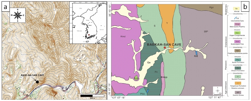
Geographic and geological setting of the Baek-ah-san cave. a) Location of the cave entrance on the regional geographic map. b) A geologic map of the surrounding area for the Baek-ah-san Cave.
백아산동굴로부터 직선거리로 약 18 km 떨어져 있는 광주기상대에서 측정한 2017년 연평균 기온은 섭씨 14.6도이며, 기온이 가장 높은 달은 7월로 27.8도, 가장 낮은 달은 12월에 1.9도로 나타났다(Korean Meteorological Administration, 2018). 연평균 습도는 68.7%를 기록하였다. 2017년 총강수량은 936.5 mm를 기록하였으나, 이는 2014년부터 2016년까지의 연평균 강수량에 비해 353.9 mm 적은 수치이다. 2017년에 가장 강수량이 높은 달은 8월로, 280.4 mm를 기록했다.
현재까지 백아산동굴에 대한 동굴지질학적 연구는 거의 이루어지지 않았으며, 매우 간략한 문화재청 자료와 함께 국립공원 무등산 권역의 지질유산학적 연구에서 일부 언급되었을 뿐이다(Ahn et al., 2014). 문화재청 동굴조사 자료에 따르면 백아산동굴의 총 길이는 약 150 m 이상(Ahn et al. (2014)의 연구에서는 약 80 m로 기재)이고, 내부에는 높이 약 5 m의 동굴폭포가 형성되어 있다(Cultural Heritage Administration, 2018).
3. 연구방법
백아산동굴의 전체적인 형태 및 구조를 파악하기 위해 동굴도(cave map)를 작성하였다(그림 2). 백아산동굴은 전반적으로 협소한 통로로 이루어져 있어 부피가 큰 정밀 측량기기를 이용하기 어렵기 때문에 레이저거리측정기(Leica, model DisotoTM D5; 측정오차 ±1.0mm)와 클리노컴퍼스(Suunto, model Tandem; 방위 및 경사 측정해상도 1°)를 활용하여 간이 동굴측량 및 보정을 실시하였다. 동굴평면도는 백아산동굴을 2차원 평면상에 투영하였을 때 육안으로 확인 가능한 최외곽선을 기준으로 작성하였고, 입구로부터 내부를 향해 단일 방향성 측량을 실시하였다. 또한, 통로의 경사와 높이를 측정하여 종단면도를 작성하였다. 동굴 바닥면의 경사를 측정할 때에는 퇴적물 유무에 관계없이 현재의 표면부를 기준으로 동굴의 바닥을 설정하였다. 작성한 동굴 도면을 기본으로 실제 조사를 통해 세부 동굴지질학적 특징을 기재하였다. 동굴 내부 조사 시 입구로부터 내부로 진입하면서 임의의 구간에 대해 동굴지질학적 특징을 지형태학적, 퇴적학적, 암석학적 특징으로 세분하여 체계적으로 기재하였고, 동굴 통로 확장에 영향을 미친 조건을 해석하였다.
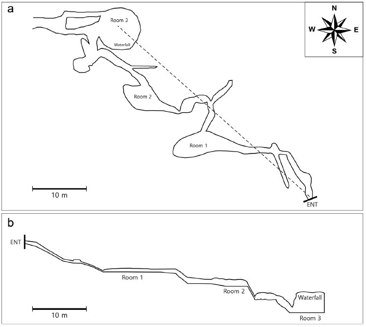
The cave map of the Baek-ah-san cave. a) A projected plan view of the cave with the datum line for the projected profile (note the dashed line). Note that the opened final section of the cave map indicates the possibility of further extensity. b) A projected profile. Note that the profile has been drawn until Room 3.
4. 연구결과
4.1 동굴의 구조와 동굴지질학적 특징
이번 연구를 통해 백아산동굴의 총길이는 약 145 m에 이르는 것으로 재확인되었다(그림 2a). 백아산동굴의 가장 심부 구간에는 연구자의 출입이 어려운 여러 갈래의 통로가 존재하기 때문에 위와 같은 총길이는 더욱 연장될 가능성이 높다. 백아산동굴 내부에는 장축 약 4.5 m 규모의 동방(cave room) 1개를 포함하여 총 3개의 소규모 동방과 각각 3 m 이상의 길이를 보이는 3갈래의 부속 통로(가지굴) 그리고 도면 상 2개의 고리형 통로(closed loop passages)가 형성되어 있는 것으로 나타났다. 전체적으로는 비교적 작은 규모인 동방 3개가 협소한 침니형(chimney) 통로에 의해 서로 연결된 구조이며, 가지굴의 발달이 미약하고 거의 하나의 주굴(main passage)로 이루어진 동굴이다. 전체 동굴의 기하학적 형태는 비교적 단순한 편이지만, 각 구간 별 통로의 규모와 형태는 불규칙한 특성을 보이고 있다. 동굴의 종단면 구조는 전체적으로 약 15도의 하향 경사를 보이며, 수평, 수직, 경사 통로가 번갈아 나타나는 계단형 종단면을 보인다(그림 2b). 입구에서 내부로 가면서 5회에 걸쳐 바닥면이 상대적으로 평탄한 통로가 나타나며, 이러한 통로들은 30~40도로 경사진 협소한 통로에 의해 서로 연결되어 있는 형태를 보인다. 또한, 평탄한 통로 구간은 대체로 평면도상의 동방 위치와 일치하는 특징을 나타내며, 동굴의 평면도와 종단면상에서 관찰되는 통로의 폭과 높이는 입구 근처에서보다 내부로 갈수록 그 규모가 점차 확장되는 경향을 보인다.
백아산동굴 입구의 상부 노두는 흑색 점판암이 박층으로 협재된 백색 내지 회색의 결정질 석회암으로 구성된 반면, 입구의 벽면은 제4기 동안 퇴적된 것으로 추정되는 준고결 상태의 각력질 두상 퇴적물(head deposits)로 구성되어 있다(그림 3, 4). 이들 퇴적물은 입구뿐만 아니라 동굴 내부 수 미터 구간까지 벽면을 따라 관찰된다(그림 4a, 4b). 입구부에 발달하는 가지굴의 횡단면은 N20W의 주향을 보이는 절리면과 나란하게 형성된 형태를 보인다. 이 가지굴은 전체적으로 폭 0.7 m 미만, 높이 0.5 m 미만의 협소한 통로로 이루어져 있으며, 점차 규모가 작아지는 구조를 보인다.

Outcrops around the cave entrance. Note a caving helmet for the scale. a) Titled and crackled outcrops right above the cave entrance (the thick arrow) and b) The entrance of the Baek-ah-san cave enclosed by crystalline limestones of the roof side and quaternary head deposits of the wall side. Dashed lines describe enlarged joints by slight displacements and dissolution.
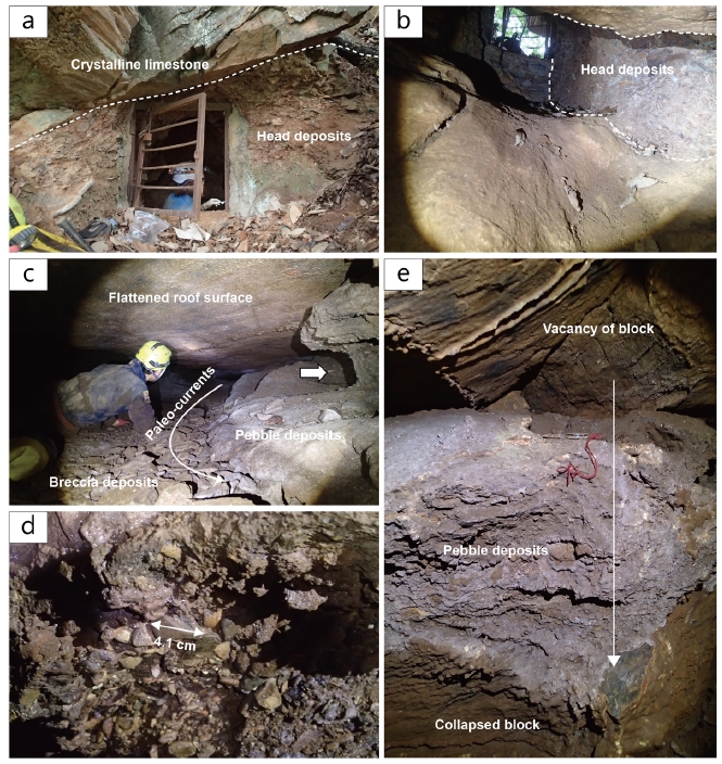
Speleological observations at both of exterior and interior area near the entrance. a) The entrance of the Baek-ah-san cave enclosed by crystalline limestones of the roof side (above the dashed line) and quaternary head deposits of the wall side (below the dashed line). Also, there is a small steel gate for the cave conservation. b) The entrance view from the cave interior. Note that cave wall is entirely composed of quaternary head deposits (an area between dashed lines). The passage height in a position taken the photograph was measured to 0.8 m. c) Gravel deposits in Room 1. The thick arrow indicates an erosional surface on the current cave wall, suggesting that most of the cave room was filled with original gravel deposits. d) Gravel deposits observed on the surface of the current cave wall. e) A breakdown observed in Room 1. Note lithified gravel deposits on the breakdown.
첫 번째 동방 구간에는 비교적 평탄한 지형의 동굴 바닥면과 천장 사이의 높이가 측면으로 갈수록 좁아지면서 소멸되는 전형적인 열극형 통로 형태를 보여준다(그림 4c). 동굴 바닥에는 전체적으로 자갈(pebble) 크기의 역으로 구성되어 있는 준고결의 역질 퇴적물이 통로의 대부분을 채우고 있으나, 통로의 중앙부는 퇴적 후 침식에 의한 역질 퇴적물이 하각된 형태를 보인다(그림 4c). 이들 역질 퇴적물은 분급과 구형도가 불량한 반면, 원마도는 양호한 편이다(그림 4d). 통로의 중앙부에는 왕자갈(cobble) 내지 거력(boluder)에 해당하는 각력질 입자들이 기질 없이 퇴적되어 있으나 천장부에서는 이들 입자를 발생시킨 낙석면의 흔적이 전혀 관찰되지 않는다(그림 4c). 첫 번째 동방 구간에서는 극히 일부이긴 하나 초거력(megaclasts)이 관찰되는데(그림 4e), 이러한 초거력의 상부 천장에는 낙반이 유래된 단열면을 관찰할 수 있다. 초거력의 상부에도 역시 준고결 역질 퇴적물이 관찰되어 이 구간에 역질 퇴적물이 공급되기 이전에 낙반이 발생할 수 있는 크기의 공동이 존재했음을 지시하고 있다.
첫 번째 동방에서 세 번째 동방 사이의 구간에서는 전형적으로 상부포화대(epiphreatic zone) 내지 통기대(vadose zone)에서 형성된 용식 구조들이 특징적으로 관찰된다(그림 5). 과거 오랜 기간 동안 안정적으로 유지된 동굴 유로(cave channel)상 수면을 지시하는 미지형인 노치(notch)가 관찰되며(그림 5a), 수 센티미터 규모의 스캘럽(scallop)이 일부 구간의 천장에서 관찰된다(그림 5b). 스캘럽의 방향은 입구에서 동굴 내부 방향을 지시하고 있어 고수류가 난류의 흐름 체제를 보이며 내부를 향해 흘렀음을 지시하고 있다. 이 구간의 벽면을 구성하는 결정질 석회암은 내부에 다수의 이질층을 포함하는 특징을 보이며, 표면으로부터 차별침식 구조를 뚜렷하게 관찰할 수 있다(그림 5c, 5d). 이 구간 통로의 하부에서는 괴상의 결정질 석회암이 우세하게 용식되어 협곡형(canyon-type) 내지 역열쇠형(reversed keyhole-shape) 단면을 보이기도 한다. 이질 엽층리가 다수 포함된 결정질 석회암 중 엽층리 경계면을 따라 침출되는 동굴수에 의해 동굴생성물 및 석회암이 용해된 흔적을 관찰할 수 있다. 동굴 벽면이 움푹한 지형을 보이는 구간에서는 미고결 퇴적층의 단면이 소규모로 관찰되는데, 원마도가 양호한 자갈 크기의 원반형 역들이 이질 퇴적물을 기질로 하여 함께 퇴적되어 있다(그림 5e). 선행 연구결과에 의하면, 백아산동굴에서 채취한 이질 퇴적물의 주 구성광물은 주로 기반암에서 풍화되어 잔류된 것으로 사료되는 석영, 운모, 장석, 질석이 주를 이룬다(Kim et al., 2018). 이 구간의 끝부분에서는 점차 천장의 높이가 2 m 이상으로 확장되면서 박층의 이질부를 경계로 수 m 크기의 결정질 석회암이 붕괴된 특징을 보여준다(그림 5f).
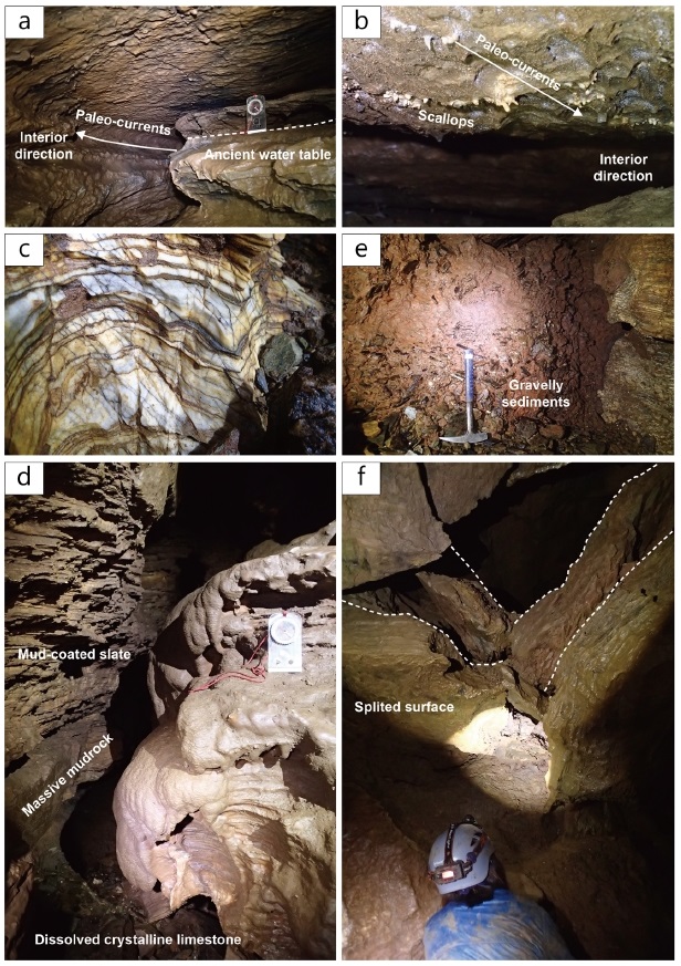
Speleological observations at the middle section of the cave. a) Niche and notch indicating the water level in the past. b) Small-sized scallops on the cave roof. The widths of scallops are typically less than 4 cm. c) A crystalline limestone interbedded with thin shale layers. A gravel size on the right-side of the photograph is 7 cm. d) Gravel deposits in the concave part of the cave passage. e) A canyon-type cross section showing the differential dissolution of parent rocks composed of slate, mudrock and limestone beds. f) Breakdowns from the cave roof by gravity and splitted slate layers.
세 번째 광장 구간에서는 최대 5.5 m의 낙차를 보이는 동굴 폭포가 발달되어 떨어지는 물에 의한 하각과 함께 진행된 수직형 통로의 확장을 보여준다(그림 6). 이 동굴 폭포 구간의 벽면에서는 수십 cm 규모의 변위를 보이는 소규모 단층들이 관찰된다(그림 6a, 6b). 이 폭포의 상단에서는 주로 차별 침식 구조가 뚜렷한 석회질 점판암층이 수십 cm 두께로 관찰된다(그림 6b).
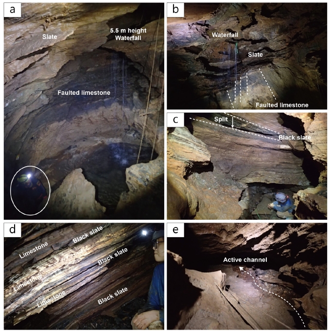
Speleological observations at the deepest section of the cave. a) 5.5 m height waterfall in the cave. Note the upper part of the waterfall commenced with slate beds. b) Waterfall view from the bottom. A series of normal faults have been observed in the lower part of the waterfall. Refer to a) for a scale. c) A large scale breakdown block produced by splitting of a slate layer. d) Interbedded limestone and slate layers observed from cave wall. e) The cave stream channel flowing out from the deepest section of the cave. The passage height in a position taken the photograph was measured to 0.4 m.
동굴 폭포로부터 최심부까지의 구간에서는 점판암층 내지 이질층의 쪼개짐으로 인한 붕괴가 극히 우세하게 관찰되며, 이로 인해 수 m 크기의 낙반이 기계적 분리(mechanical disintegrations)에 의해 일정한 면을 따라 발생된 것을 확인할 수 있다(그림 6c, 6d). 백아산동굴의 최심부 바닥 부분에는 동굴 폭포로부터 이어지는 동굴수에 의해 수로(channel) 구간이 형성되어 있으며, 전반적으로 분급이 불량한 역질 퇴적물이 수로의 바닥을 채우고 있다(그림 6e).
4.2 동굴생성물 분포
백아산동굴에서는 다양한 종류의 탄산염 동굴생성물(speleothem)이 관찰되는데 반해, 그 발달 상태는 미약한 편이다. 현재까지 관찰된 동굴생성물의 종류는 종유관, 종유석, 커튼(draperies), 석순, 동굴진주(cave pearls) 등 천장에서 떨어지는 동굴수에 의해 형성되는 동굴생성물들과 유석, 휴석(rimstone), 타이어(tier) 등 바닥면을 흐르는 동굴수에 의해 형성된 동굴생성물 그리고 발달이 미약한 붕암(shelfstone) 및 동굴수지(pool fingers) 등 정체된 고인 물에서 발달하는 동굴생성물들이 관찰되었다(그림 7). 상대적으로 발달상태는 매우 미약한 편이지만, 동굴산호(cave coralloids), 곡석(helictites) 등 동굴벽면으로부터 스며 나오는 침출수 또는 형성원인이 불분명한 동굴생성물들도 일부 관찰된다. 백아산동굴의 동굴생성물 중에서 동굴산호와 붕암의 주 구성광물은 Mg가 풍부한 방해석(Mg-rich calcite)으로 이루어져있는 사실이 선행연구를 통해 밝혀진 바 있다(Kim et al., 2018). 백아산동굴의 전체 구간에서 가장 우세하게 발달한 동굴생성물의 종류는 유석과 석순으로서 현재 거의 대부분이 훼손된 상태이지만, 최심부에 발달해 있는 유석의 경우 높이 2 m, 폭 3 m 이상의 대형 유석이 원형 그대로 관찰되기도 한다(그림 7e). 이에 반해 매우 천천히 공급되는 미량의 동굴수에 의해 형성되는 종유관 등 동굴생성물은 극히 일부 구간에서만 제한적으로 관찰된다. 특히, 입구부에서 관찰되는 동굴생성물은 우기임에도 불구하고 표면부가 건조한 상태로 나타나지만, 두 번째 동방구간을 지나면서 동굴생성물의 표면에 물기가 관찰된다.
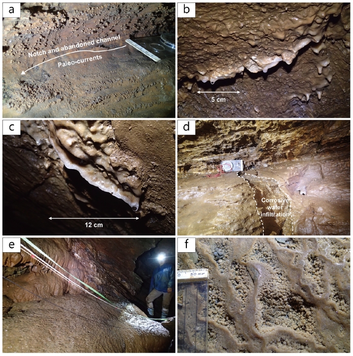
Speleothems of the Baek-ah-san cave. a) Cave-coralloids on the wall surface showing notch structures. b) Small stalactites and a broken curtain. c) An active curtain. d) Thin flowstone crusts with the corroded surface. e) Well-preserved flowstone with a large number of tiers. f) A close-up view of tiers with tiny cave popcorns.
5. 토 의
5.1 백아산동굴의 동굴지질학적 분석
이번 연구에서는 백아산동굴의 동굴지질학적 특성을 지형태학적, 퇴적학적, 암석학적 특성으로 분류하여 해석하였고, 지형태학적 특성은 다시 규모에 따라 대규모, 중규모, 소규모 지형으로 나누어 해석하였다(표 1). 백아산동굴의 전반적인 기하학적 형태는 비교적 단순한 편으로 평면상에서 가지굴의 발달이 미약하고 거의 단일 주굴로 이루어진 초기 형태의 가지형 동굴(branchwork cave)로 해석된다(그림 2; Palmer, 1991; Dom and Wicks, 2003). 이러한 해석은 주굴의 폭과 높이가 입구에서부터 내부로 갈수록 규모가 점차 확장되는 경향성과 상부카르스트지역(epikarst)으로부터의 동굴수 함양이 입구 부근의 가지굴 시작점을 비롯하여 주로 특정 점원(point-source)을 통해 이루어지면서 주굴로 합류하는 형태를 보인다는 점을 통해 확인할 수 있다(그림 2; 표 1). 종단면상에서 관찰되는 계단형태의 동굴 구조는 백아산동굴 모암의 암석학적 특성이 반영된 결과로서, 용해성 지층과 불투수성 지층의 반복적인 교호에 의한 전형적인 횡와(flat-lying) 구조의 특성을 보이고 있다(Ford and Williams, 2007). 종단면상의 가지굴들 역시 독립적으로 발달하여 주굴로 합류한다는 점에서 가지형 동굴을 지시하고 있다. 따라서 대규모 지형태학적 특성에 의하면 백아산동굴의 현재 형태는 주로 상부포화대 조건에서 완성된 것으로 해석할 수 있으며, 입구부 인근 지점은 이후 통기대 조건에서의 동굴 발달에 우세하게 영향 받았음을 보여준다(표 1).
백아산동굴의 중규모 지형태학적 특징 중 하나는 비교적 평탄한 바닥면을 보이는 3개의 동방 구간이 서로 독립적으로 존재한다는 것으로, 동굴 폭포 구간을 제외한 나머지 2개 동방의 횡단면 형태는 수평방향으로 확장된 타원형을 보여준다. 이들 동방의 통로 대비 상대적 규모와 형태는 동방 간 연결 이전 정체되었거나 지하수의 흐름이 매우 느린 포화대(phreatic zone) 또는 상부포화대에서 최초의 동방이 형성되었을 것으로 추정된다(표 1; Lauritzen and Lundberg, 2000). 이에 반해 3개의 동방과 최심부 수평 통로 구간을 제외하고 이들을 서로 연결하고 있는 통로들의 경우, 전반적으로 협소한 침니형(chimney-type) 통로들이 우세한 것으로 보아 주로 상부포화대와 통기대에서 상대적으로 빠른 유속의 유수에 의해 형성되었거나 홍수기 등 간헐적으로 통로 바닥면을 흐르는 유수에 의해 형성된 것으로 판단된다(Ford and Williams, 2007). 중규모 지형태학적 특징 중 노치(notch)는 상부포화대를 지시하는 동시에 장기적으로 유지된 지하수면을 지시하고 있다(Palmer, 2007). 백아산동굴 최심부에서는 여러 갈래의 소규모 고리형 통로들이 발달한 망상형 통로(anastomosis)의 특징을 보이는데, 이는 통로의 확장보다는 유로의 완만한 경사와 동굴수량의 큰 변화로 인하여 동시에 여러 통로를 통해 지하수를 배수하는 형태가 형성된데 기인한다(Šebela et al., 2004). 백아산동굴의 경우 폭우 시 지하수의 배수가 효과적으로 이루어지지 못하고 동굴 최심부가 쉽게 범람하게 될 것으로 예상되는데, 이러한 백아산동굴의 특징이 망상형 통로를 형성하게 된 조건을 마련하였을 것으로 판단된다. 소규모 지형태학적 특징 중 센티미터 크기의 스캘럽은 통로 형성 당시 고수류가 입구 방향에서 동굴 내부로 흐르는 난류의 흐름체제를 보였다는 것을 명확히 지시해주고 있다. 특히, 이러한 소규모 스캘럽의 존재는 상부포화대 근처에서 유속이 비교적 느린 상태를 지시한다(Curl, 1974). 이와 같은 중소규모 지형태학적 증거를 종합해보면 백아산동굴의 동방 구간과 그 인근에서는 포화대 조건을 지시하는 특징이 뚜렷하게 관찰되는 반면, 동방을 이어주는 통로에서는 상부포화대에서 통기대 환경에 이르는 조건에서 형성된 것으로 해석할 수 있다.
백아산동굴에서는 입구부터 다양한 특징을 보이는 퇴적물이 관찰되며, 이들을 통해 현재까지 해석한 동굴 형성 조건을 검증할 수 있다. 동굴입구의 벽면은 신생대 제4기 동안 퇴적된 것으로 추정되는 준고결 상태의 각력질 두상 퇴적물로 구성되어 있는데, 이는 산사면과 동굴 입구부분에 퇴적된 두상 퇴적물 위로 동굴 입구부 노두가 내려앉아 형성된 것으로 해석된다(Šušteršič, 2004; 그림 3, 4). 이후 지표수가 동굴 입구를 통해 내부로 공급되면서 지하수와 함께 두상 퇴적물 일부가 침식 및 이동되었을 것으로 판단된다. 따라서 통로의 배치, 경사 조건, 추정한 공급지와 퇴적지점 사이의 거리를 고려했을 때(그림 2), 첫 번째 동방 구간에서 관찰된 자갈 크기의 준고결 역질 퇴적물은 입구로부터 공급되었고, 주로 간헐적인 폭우 시 급격하게 증가된 동굴수 흐름이 협소한 입구부 통로를 거쳐 상대적으로 넓고 평편한 첫 번째 동방 구간에 이르러 다량의 역질 퇴적물을 퇴적시킨 것으로 해석된다(Bosch and White, 2004). 이렇게 형성된 퇴적물은 해당 구간이 점차 상부포화대를 거쳐 통기대 환경으로 전이되고 동굴 내부 통로가 확장 발달하면서 배수능력이 향상된 이후 범람 없이 통로의 중앙부로 간헐적인 동굴수가 유입되어 이차적인 퇴적물 침식과 재동이 발생된 것으로 판단된다(그림 4; Bosch and White, 2004). 또한, 이들 통로 중앙부 유로 침식 흔적 내에서 관찰되는 기질 없는 왕자갈(cobble) 내지 거력(boluder) 크기의 각력 입자들은 입구부로부터 역질 퇴적물 유입 이전 포화대 공동 형성 중 천장부에서 낙하한 각력으로 해석될 수 있다(White and White, 2000). 따라서 이러한 각력들은 통로의 크기가 최소한 낙석이 발생할 수 있는 공간이 있었던 반면, 천장에서 낙석면의 흔적이 전혀 관찰되지 않는 것은 공생작용(paragenesis) 등에 의해 상당 기간 동안 동굴 천장 부분이 우세하게 용해된 결과를 지시한다(Lauritzen and Lundberg, 2000). 이와 같은 동방에 국한된 공동 형성 초기 낙석 발생과 퇴적물 유입 등 일련의 사건은 첫 번째 동방에서 관찰된 초거력 크기의 낙반과 낙반 상부를 피복하고 있는 준고결 역질 퇴적물을 통해서도 확인할 수 있다(그림 4e).
두 번째 동방 부근부터 동굴폭포 이후 최심부 구간까지 극히 우세하게 관찰되는 대형 낙반은 석회암층 사이에 협재된 박층의 점판암이 중력을 이기지 못하고 쪼개짐이 발생함에 따라 생성된 것이다(그림 5f, 6c; White and White, 2000). 이렇게 모암의 암석학적 특성에 의한 퇴적물 및 지형 조절은 다른 예에서도 볼 수 있는데, 백아산동굴의 동굴폭포는 석회암층과 점판암층을 끊고 발달한 일련의 소규모 단층에 의해 지하수 흐름의 낙차가 발생됨으로써 지속적으로 낙차가 증가하고 폭포가 후퇴하면서 현재의 모습에 이른 것으로 전형적인 동굴폭포 형성을 보여준다(그림 6a, 6b; Lauritzen and Lundberg, 2000). 이와 같은 특징들은 동굴을 포함하고 있는 지층의 암질 특성에 따라 동굴 내부 구조 및 환경이 크게 영향 받을 수 있음을 보여주는 예로 생각된다. 즉, 동굴형성 초기에는 주로 포화대 용해작용이 독립된 초기 공동 형성에 중요하게 기여하는 반면, 통로가 확장되면서 상부포화대 내지 통기대 조건에서 점판암층의 물리적 쪼개짐에 의해 현재와 같은 백아산동굴의 특징을 이루었을 것으로 해석된다. 이와는 반대로 백아산동굴의 통로는 일정 크기 이상 대규모 발달이 이루어지기 어려울 것으로 판단되는데, 그 이유는 쪼개짐이 우세한 박층의 이질층을 포함하는 암질 특성으로 인해 동굴의 붕괴가 흔히 발생될 가능성이 매우 크기 때문이다.
백아산동굴의 동굴생성물 표면에서는 통로 형성 이후 동굴 범람(cave flooding) 등 급격한 수리지질학적 현상에 의한 동굴생성물의 침식이 발생된 흔적을 쉽게 찾을 수 있으며, 흔히 동굴생성물 형성 후 재용해된 흔적이 관찰된다(그림 7d). 이러한 특징들은 백아산동굴 내부에 지속적으로 안정적인 물 공급이 이루어졌다기 보다는 동굴수의 유량과 지화학적 특성이 때에 따라 크게 변화하였고, 강수가 동굴 내부에 이르는 체류 시간도 크게 변하면서 동굴수에 용해된 이산화탄소 및 탄산칼슘 성분의 양이 단시간 동안 크게 변할 수 있음을 암시해주고 있다(Palmer, 2007).
5.2 백아산동굴의 형성과정
백아산동굴 내부에서 확인한 지형태학적, 퇴적학적, 암석학적 특징들을 토대로 해석한 통로 형성 조건을 각각 비율로 나타내었다(표 1; 그림 8). 이 결과는 상대적으로 긴 조사 길이를 보이는 대규모 지형태학적 특징에 의해서 편향된 결과를 나타낼 수 있으므로 이 연구에서는 대규모 지형태학적 특징을 포함시킨 비율과 대규모 지형태학적 특징을 제외한 비율을 함께 제시하였다. 대규모 지형태학적 특징을 제외하여 분석한 결과에서는 포화대에서 발달한 것으로 해석되는 통로가 전체 조사 길이의 5.1%, 포화대에서 상부포화대 구간에서 형성된 통로는 8.2%, 상부포화대를 지시하는 통로의 길이는 11.2%로 나타나 점차 증가하는 양상을 보여주었으나, 상부포화대-통기대 구간에서 형성된 통로는 48.4%로 압도적으로 높은 비율을 나타내었다. 통기대 발달을 지시하는 통로는 27.0%로 여전히 높은 비율을 차지하지만 상부포화대-통기대 구간에 비해서는 낮은 비율을 차지한다. 또한, 대규모 지형태학적 특징을 포함시킨 분석결과에서는 포화대, 포화대-상부포화대, 상부포화대, 상부포화대-통기대, 통기대의 비율이 각각 1.9, 3.0, 18.4, 66.9, 27.0%로 나타나 상부포화대-통기대에서 가장 높은 비율을 차지했다는 점과 상부포화대 및 통기대 조건이 상대적으로 우세한 것으로 나타났다는 점에서 일관성 있는 결과를 보여주었다.
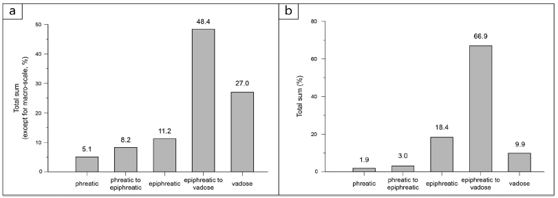
The statistical results on the location of passage formation based on the speleological evidences presented in this study. a) Results excepting macro-scale geomorphic evidences from the cave map. b) Results reflecting all the speleological observations.
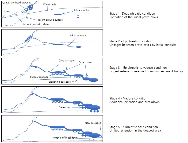
이와 같은 결과는 백아산동굴의 초기 공동 형성이 포화대에서 시작되어 동굴의 최대 확장은 주로 상부포화대 조건에서 이루어진 후 지하수면이 지속적으로 하강함에 따라 통기대에서의 동굴형성에 의한 특징이 중첩되는 양상을 의미하고 앞서 기술한 동굴지질학적 특징에 의해 해석된 동굴형성과정을 지지한다. 비록 포화대에서의 초기 공동 발달은 동방 지점 등 일부 구간에 국한되었을 것으로 추정되지만, 이후 상부포화대와 통기대 조건을 거치면서 추가적인 용해, 침식, 붕괴 과정을 거친 최종 결과이기 때문에 이 연구에서 제시한 초기 포화대 공동 발달의 비율은 최소치를 나타내는 것으로 판단된다. 따라서 백아산동굴 형성 초기에는 포화대 내에서 미소규모의 독립적 공동이 동시다발적으로 형성되고, 점차 하강하는 지하수면에 의해 공동이 상부포화대에 이르렀을 때 공동의 확장과 함께 초기 공동의 연결이 통로(conduit)를 통해 이루어졌을 것으로 판단된다(Ford and Williams, 2007). 또한, 상부포화대-통기대 전이 조건에서는 간헐적인 동굴 범람의 영향으로 가장 활발한 용식작용이 발생되었을 것으로 해석된다. 따라서 현재 동굴폭포를 거쳐 지하수가 흐르고 있는 백아산동굴의 최심부 구간에서 볼 수 있듯이 상부포화대-통기대 전이 조건이 백아산동굴의 현재 규모 및 구조로 형성된 가장 주요한 조건으로 판단된다.
현재까지의 동굴지질학적 연구결과 및 해석을 통해 백아산동굴의 형성 단계를 총 5단계로 요약할 수 있다(그림 9): 1) 포화대-상부포화대 미소규모 독립 공동 형성단계, 2) 상부포화대 공동 연결 단계, 3) 상부포화대-통기대 최대 확장 단계 4) 통기대 추가 확장 단계, 5) 현재 최심부 연장 단계. 5단계 동안 지하수면의 하강 속도에는 큰 차이가 있을 수 있지만 동굴 외부 계곡의 발달 및 하각으로 인해 장기적 시간 규모에서 지속적인 지하수면 하강이 이루어졌을 것으로 추정된다. 동굴지질학적 관점에서 백아산동굴은 변성퇴적암류에서의 전형적인 용해 동굴 형성모델을 제시해주고 있다(Palmer, 2007). 특히, 동굴길이 및 규모의 확장이 지하수면 하강과 서로 연결되어 있음을 확인시켜준다는 점과 미소규모의 초기 포화대 공동 형성 후 연결 통로의 발달이 이루어지는 과정을 보여준다는 점 등을 백아산동굴이 제시해주는 주요 동굴지질학적 특성으로 들 수 있다.
6. 결 론
전남 화순에 위치한 시도기념물 제24호 백아산동굴은 주로 평면도상에서 관찰되는 지형태학적 특징들에 의해 가지형 동굴로 분류된다. 이번 연구에서는 백아산동굴의 전체적인 동굴형성과정이 점진적 지하수위 하강과 동굴을 포함하는 모암의 암석학적 특징에 의해 큰 영향을 받은 것으로 해석하였다. 백아산동굴은 포화대 내 초기 용해 공동 형성 단계에서부터 상부포화대-통기대 영역의 최대 확장 단계까지 전이되는 과정을 거쳐 형성되었으며, 다량의 퇴적물 공급, 이동 및 침식에 의해 큰 영향을 받은 것으로 보인다. 또한, 지하수위 하강과 동시에 점차 증가하는 하중을 받는 동굴천장부 암석 내부에서 이질층의 쪼개짐이 발생되어 다수의 낙반과 낙석이 발생하는 현재의 백아산동굴을 이룬 것으로 해석된다. 이러한 백아산동굴의 동굴지질학적 연구결과는 기존 용해 동굴 특히 변성퇴적암류에 분포하는 석회암동굴의 형성과정을 설명하는 좋은 모델을 제시해주고 있다.
Acknowledgments
이 연구는 2018년도 정부(과학기술정보통신부)의 재원으로 한국연구재단의 지원을 받아 수행된 기초연구사업(No. NRF-2015R1A4A1041105)과 신진연구자지원사업(No. NRF-2016R1C1B2016525)의 일환으로 수행되었다. 또한, 부분적으로 화순군의 재정지원(2017-2018년)과 2017년도 강원대학교 대학회계 학술연구조성비(관리번호-520170521)로 연구하였다.
References
-
Ahn, K.-S., Huh, M., and Son, J.-M., (2014), Geological history and landscape of Mudeungsan National Park, Journal of the Geological Society of Korea, 50, p91-105, (in Korean with English abstract).
[https://doi.org/10.14770/jgsk.2014.50.1.91]

- Ahn, U.S., and Hwang, S.K., (2008), Interpretation of formation and growth processes of Manjang Lava Tube through detailed surveying with electronic total station, Journal of the Geological Society of Korea, 44, p657-672, (in Korean with English abstract).
-
Bosch, R., and White, W.B., (2004), Lithofacies and transport of clastic sediments in karstic aquifers, In: Sasowsky, I.D., and Mylroie, J. (eds.), Studies of cave sediments, Springer, Dordrecht, p1-22.
[https://doi.org/10.1007/978-1-4419-9118-8_1]

- Choi, D.W., Woo, K.S., Kim, R., and Lee, K.C., (2003), The origin of the Okgye Cave and the genesis of speleothems, Kangneug, Korea, Journal of the Geological Society of Korea, 39, p41-64, (in Korean with English abstract).
- Cultural Heritage Administration, (2018), http://www.heritage.go.kr/heri/unified/selectUnifiedList.do?mn=&pageNo=5_1_1_1 (August 31, 2018).
- Curl, R.L., (1974), Deducing flow velocity in cave conduits from scallops, National Speleological Society Bulletin, 35, p1-5.
- Dom, J.E., and Wicks, C.M., (2003), Morphology of the caves of Missouri, Journal of Cave and Karst Studies, 65, p155-159.
-
Ford, D., and Williams, P., (2007), Karst hydrogeology and geomorphology, John Willey & Sons, Ltd., Chichester, p209-265.
[https://doi.org/10.1002/9781118684986]

-
Gunn, J., (2004), Encyclopedia of caves and karst science, Taylor & Francis Books, Inc., New York, p203-205.
[https://doi.org/10.4324/9780203483855]

- JeollaNamdo, (2018), http://www.jeonnam.go.kr/T7139/boardView.do?seq=1925944&menuId=jeonnam0911020300&boardId=T7139 (January 3, 2018).
- Kim, B.K., and Park, B.K., (1966), Explanatory text of the geological map of Dongbok sheet (1:50,000), Geological Survey of Korea, p9, (in Korean with English abstract).
-
Kim, Y., Seo, H., Jo, K-N., Jung, D-Y., Shin, S., Huh, M., and Roh, Y., (2018), Carbonate biomineralization using speleothems and sediments from Baekasan Acheon Cave (limestone cave) in Hwasun-gun, Jeollanam-do, South Korea, Journal of Mineralogical Society of Korea, 31, p113-121.
[https://doi.org/10.9727/jmsk.2018.31.2.113]

- Korea Meteorological Administration (KMA), (2018), http://www.weather.go.kr/weather/climate/past_cal.jsp (August 31, 2018).
- Lauritzen, S.-E., and Lundberg, J., (2000), Solutional and erosional morphology of caves, In: Klimchouk, A.B., Ford, D.C., Palmer, A.N., and Dreybrodt, W. (eds.), Speleogenesis: Evolution of karst Aaquifers, National Speleological Society, Inc., Alabama, p408-426.
-
Palmer, A.N., (1991), Origin and morphology of limestone caves, Geological Society of America Bulletin, 103, p1-21.
[https://doi.org/10.1130/0016-7606(1991)103<0001:oamolc>2.3.co;2]

- Palmer, A.N., (2007), Cave geology, Cave Books, Dayton, p1-301.
-
Šebela, S., Slabe, T., Hong, L., and Pruner, P., (2004), Speleogenesis of selected caves beneath the Lunan Shilin and caves of Fenglin karst in Qiubei, Yunnan, Acta Geologica Sinica, 78, p1289-1298.
[https://doi.org/10.1111/j.1755-6724.2004.tb00786.x]

- Šušteršič, F., (2004), Cave sediments and denuded caverns in the Laški Ravnik, classical karst of Slovenia, In: Sasowsky, I.D., and Mylroie, J. (eds.), Studies of cave sediments, Springer, Dordrecht, p123-134.
- White, E., and White, W., (2000), Breakdown morphology, In: Klimchouk, A.B., Ford, D.C., Palmer, A.N., and Dreybrodt, W. (eds.), Speleogenesis: Evolution of karst aquifers, National Speleological Society, Inc., Alabama, p427-429.
- White, W.B., (1988), Geomorphology and hydrology of karst terrains, Oxford University Press, New York, p464.
- Won, C.K., (2000), A report on the present state and a conservation plan for show caves nominated as natural heritage sites, Cultural Heritage Administration, p217, (in Korean).
- Woo, K.S., (2005), A report on the scientific investigation for natural caves, Pyeongchang, p17-18, (in Korean).
- Woo, K.S., and Kim, R., (2004), 2002 Nationalwide investigation on natural caves (Hwangtigi and Wooro caves in Mungyeong and Bonghwa area), National Institute of Environmental Research, p317-349, (in Korean).

