
캐나다 앨버타주 전기 백악기 맥머레이층의 유성이토 퇴적층
초록
유성이토는 현생 염하구 환경에서 흔히 발달하지만, 고기의 퇴적층에서 보고되고 퇴적학적으로 연구된 예는 드물다. 캐나다 앨버타주의 전기 백악기 맥머레이층에서 시추한 염하구 하도 퇴적층 내의 여러 이암층들은 고농도부유점토류에 의한 퇴적특징을 보인다. 이러한 이암층들을 현미경으로 자세히 관찰하여 3개의 미퇴적상(microfacies, <1~25 mm 두께)으로 구분하였다. 미퇴적상 1은 무구조의 이암(structureless mudstone)으로 주로 점토 입자로 구성되고 무질서하게 분포하는 조립질 입자(조립질 실트~세립질 모래)들을 포함한다. 조립질 입자들을 지지할 수 있는 양력을 지닌 점착성의 이토류, 즉 유성이토가 정지하여 미퇴적상 1이 퇴적된 것으로 해석된다(quasi-laminar plug flow). 미퇴적상 2는 실트엽층을 포함하는 이암(silt-streaked mudstone)으로 산재한 조립질 입자를 포함하는 이암으로 구성되며, 불연속적이고 매우 얇은 실트엽층을 포함한다. 미퇴적상 1과 유사한 조직을 보이므로, 미퇴적상 2도 점착성의 유성이토에 의해 퇴적된 것으로 해석된다. 하지만 불연속적인 실트엽층은 plug 아래에 간헐적이고 약한 난류운동이 있었음을 제시한다(upper transitional plug flow). 미퇴적상 3은 이질 엽층리의 이암(heterolithic laminated mudstone)으로 실트엽층과 점토엽층의 교호로 구성되며, 평행엽층리 또는 저각도 사엽층리를 보이고 간혹 낮은 기복의 연흔 형태를 보인다. 이질 엽층리는 점착성 plug 아래의 난류층에서 입자크기에 따른 분급작용이 일어났음을 지시하며, lower transitional plug flow 아래에서 발달하는 낮은 층면구조에 의해 형성되었을 것으로 해석된다. 이 미퇴적상들은 유속과 부유이토농도에 따라 달라지는 유성이토의 여러 가지 상을 나타낸다고 볼 수 있다. 다른 지역에서 유성이토층을 인지하고 이암의 퇴적작용을 보다 잘 이해하는데 본 연구의 결과가 중요한 지식을 제공하리라 생각된다.
Abstract
Fluid muds commonly occur in estuarine environments, but their ancient examples have rarely been studied in terms of depositional characteristics and processes. Cores of estuarine channel deposits of the Early Cretaceous McMurray Formation, Alberta, Canada show various mudstone layers that possess depositional characteristics of high clay-concentration flows. These mudstone layers are examined in detail through microscopic observation of thin sections and classified into three microfacies (<1 to 25 mm thick) on the basis of sedimentary texture and structures. Structureless mudstone (Microfacies 1) consists mainly of clay particles and contains randomly dispersed coarser grains (coarse silt to fine sand). This microfacies is interpreted as being deposited by cohesive mud flows, i.e., fluid muds, which possessed sufficient strength to support suspended coarser grains (quasi-laminar plug flow). Silt-streaked mudstone (Microfacies 2) mainly comprises mudstone with dispersed coarse grains and includes very thin, discontinuous silt streaks of coarse-silt to very-fine-sand grains. The texture similar to Microfacies 1 indicates that Microfacies 2 was also deposited by cohesive fluid muds. The silt streaks are, however, suggestive of the presence of intermittent weak turbulence under the plug (upper transitional plug flow). Heterolithic laminated mudstone (Microfacies 3) is characterized by alternation of relatively thick silt laminae and much thinner clay laminae. It is either parallel-laminated or low-angle cross-laminated, occasionally showing low-amplitude ripple forms. The heterolithic laminae are interpreted as the results of shear sorting in the basal turbulent zone under a cohesive plug. They may represent low-amplitude bed-waves formed under lower transitional plug flows. These three microfacies reflect a range of flow phases of fluid muds, which change with flow velocities and suspended mud concentrations. The results of this study provide important knowledge to recognize fluid-mud deposits in ancient sequences and to better understand depositional processes of mudstones.
Keywords:
fluid mud, microfacies, depositional process, estuarine deposits, McMurray Formation키워드:
유성이토, 미퇴적상, 퇴적작용, 염하구 퇴적층, 맥머레이층1. 서 론
이토(mud)는 육상 평원의 대부분 지역, 호수, 연안의 삼각주, 염하구, 갯벌, 그리고 대륙붕에서 심해에 이르기까지 지구 표면의 가장 많은 부분을 덮고있는 퇴적물이다. 이토가 고화된 이암은 퇴적암에서 가장 큰 부피를 차지하며, 석유를 포함한 탄화수소 자원의 근원암이기도 하다. 최근에는 이암에 포함된 가스(셰일가스)의 개발이 활발하다. 이러한 중요성에 비해 이암에 대한 퇴적학적 이해는 비교적 단순한 편이다. 저탁류로부터 변환한 점착성 이토류가 멈춰서는 퇴적작용을 제외하고(Talling et al., 2012), 대부분의 이암은 물의 흐름이 거의 없는 조용한 환경에서 천천히 가라앉아 퇴적되는 것으로 이해되어 왔다. 이암의 퇴적작용에 대한 이해가 상대적으로 부족한 주요 이유 중 하나는 눈으로 관찰하기 어려울 정도로 세립질이기 때문에 야외에서 관찰하는 데 한계가 있다는 것이다. 관찰하기 어려운 이암보다 다양한 특징들을 보여주는 사암과 역암에 집중하여 퇴적작용과 퇴적환경을 해석하고자 하는 경향이 있고, 이로 인해 이암의 퇴적학적 특징과 퇴적작용에 대한 이해의 필요성이 상대적으로 간과되어 왔다.
최근 일련의 실험 연구들을 통해 이토의 퇴적작용에 대한 이해가 크게 증진되었다(Baas and Best, 2002; Baas et al., 2009, 2011, 2016). 물 속에 점토의 부유농도가 높아지면, 점토 입자 사이의 거리가 가까워지고 전하를 띠는 점토 입자들이 서로 끌어당겨 붙게 된다. 많은 점토 입자들이 서로 붙어 연결되면 유체의 난류운동이 억제되고 점착성(cohesion)이 생긴다. 부유상태의 이토 입자를 많이 포함하는 흐름이 감속되면서 이토 입자들이 서서히 침강하여 고농도를 형성하면, 난류(turbulent flow)에서 점착성 흐름(cohesive flow)으로 변환된다. 이 변환이 단순하게 난류에서 점착류로 바뀌는 것이 아니라, 여러 단계의 전이적 흐름(transitional flows)을 거칠 수 있음이 실험 연구들을 통해 밝혀졌다(Baas and Best, 2002; Baas et al., 2009, 2011, 2016). 변환 초기에 전체적으로 난류 강도가 증가하는 현상이 일어나며(turbulence-enhanced transitional flow), 점토 농도가 더 증가하면, 난류 운동이 억제되고 점착성이 우세한 plug가 발달한다. plug 발달의 초기 단계에서 plug 경계면의 불안정성에 의한 파동이 전파되어 plug와 바닥 사이의 얇은 층에 난류 운동이 우세해질 수 있다(lower transition plug flow). 농도가 더 증가하면 plug 두께가 증가하면서 흐름의 바닥에서도 난류 운동이 미미해지고(upper transitional plug flow), 결국 전체가 한 덩어리의 점착성 흐름으로 변한다(quasi-laminar plug flow). 부유 점토를 많이 함유한 흐름이 감속하여 퇴적되는 과정에서 난류가 점착류로 변환될 때, 몇 가지의 전이적 성격의 흐름을 거치므로 한 번의 퇴적사건에서 일련의 퇴적작용이 일어나고 여러 개의 퇴적층이 연관되어 형성될 수 있다. 이러한 발견을 바탕으로 고농도의 부유 점토를 포함하는 흐름, 대표적으로 세립질의 퇴적물 중력류에 의해 형성된 퇴적층에 대한 새로운 해석이 시도되고 있다(e.g., Ghadeer and Macquaker, 2011; Plint, 2014; Hovikoski et al., 2016).
캐나다 앨버타의 백악기 맥머레이층(McMurray Formation)은 오일샌드 퇴적층으로 유명하며, 특히 중부 퇴적층은 가장 양질의 비투멘(bitumen) 저류층으로 알려져 있다(Hein et al., 2000; Hein and Cotterill, 2006). 맥머레이층의 중부 퇴적층은 주로 염하구 하도(estuarine channel) 퇴적층으로 구성되는데, 조석의 영향을 받는 하도에서 퇴적된 이암층이 다양하게 발달한다. 앨버타주 크리스티나레이크(Christina Lake) 지역의 맥머레이층에서 획득한 시추 코어에도 염하구 하도 퇴적층 내에 다양한 이암층들이 발달한다. 그 중 다수의 이암층은 어떠한 내부구조를 보이지 않고 균질하며, 산재하여 분포하는 조립질 실트에서 세립질 모래 크기의 입자들을 포함한다. 이러한 특징은 고농도 부유 점토에 의해 점착성을 갖는 흐름, 즉 유성이토(fluid mud)에 의해 퇴적되었음을 제시한다. 무구조의 이암과 함께 산출하는 이 암층들에 미세한 엽층리들이 발달하는데, 이 이암층들 또한 유성이토와 관련되어 퇴적되었을 것으로 생각된다. 본 연구에서 이러한 이암층들을 현미경으로 자세히 관찰하여 퇴적상을 구분하고, 이들을 유성이토에 의한 퇴적으로 해석하였으며, 이를 통해 유성이토 퇴적층의 특징을 규명하였다.
2. 층서 및 퇴적환경
맥머레이층은 압티안(Aptian)에서 알비안(Albian) 동안 서캐나다 퇴적분지(Western Canada Sedimentary Basin)에 퇴적된 맨빌층군(Mannville Group)의 최하부층으로 고생대 데본기 탄산염암층 위에 부정합적으로 놓인다(그림 1, 2) (Flach and Mossop, 1985; Leckie and Smith, 1992; Stockmal et al., 1992; Cant, 1996; Ranger and Pemberton, 1997; Wightman and Pemberton, 1997). 맥머레이층은 해침 동안 형성되어 퇴적환경에 따라 하부, 중부, 상부로 나뉘는데, 하부 맥머레이층은 저해수면 시기동안 형성된 망상하천 퇴적층으로 구성된다(Mossop and Flach, 1983; Crerar and Arnott, 2007). 중부 맥머레이층은 조석 영향을 받은 하도 내지 염하구 퇴적층으로 구성되며, 해침 초기에 형성되었다(Mossop and Flach, 1983; Flach, 1984; Flach and Mossop, 1985; Crerar and Arnott, 2007; Musial et al., 2012). 상부 맥머레이층은 해침 초기와 중기에 형성된 외연안 퇴적층으로 해석된다(Hein et al., 2000; Hein and Cotterill, 2006; Crerar and Arnott, 2007; Hein, 2015).
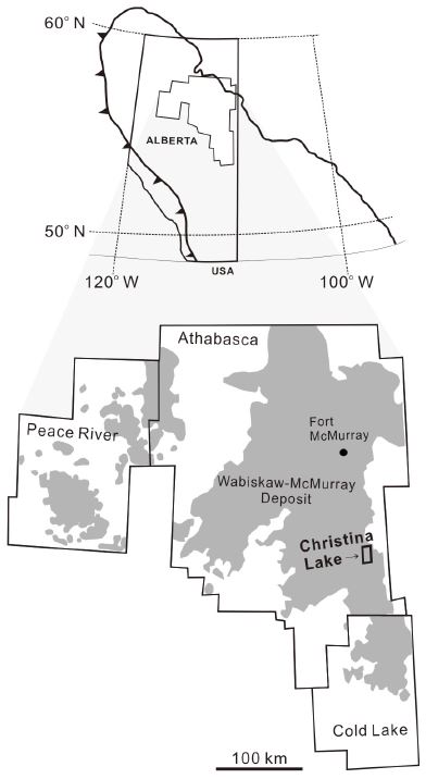
The location of the study area (Christina Lake) and major oil-sands accumulation areas (Athabasca, Peace River, and Cold Lake) in the Western Canada sedimentary basin. Modified from Cant (1996) and Alberta Energy and Utilities Board (2007).
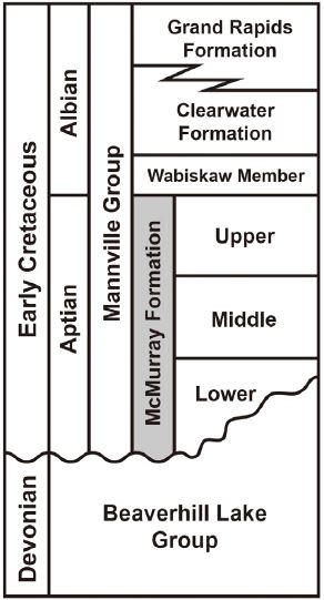
Stratigraphy of the Early Cretaceous Mannville Group in the study area. The McMurray Formation overlies unconformably the Devonian limestone of the Beaverhill Lake Group.
본 연구에서 분석된 코어(6-5-77-6)는 캐나다 앨버타주의 크리스티나레이크 지역에서 획득되었다(그림 3). 이 지역의 맥머레이층은 데본기 비버힐레이크(Beaverhill Lake) 석회암 위에 부정합적으로 놓인다(그림 2) (Jo and Ha 2013a; Shinn et al., 2014; Hein, 2015). 이 부정합면은 맥머레이층이 퇴적될 당시 동북동-서남서 방향으로 발달한 고계곡의 지형을 반영한다(그림 3) (Jo and Ha, 2013a, 2013b). 맥머레이층을 형성한 하천 시스템은 이 고계곡을 따라 동쪽으로 흘러 맥머레이 하천시스템의 본류로 합류하고 아시니보아 계곡(Assiniboia valley)을 따라 북쪽으로 흘렀다(Leckie and Smith, 1992; Ranger and Pemberton, 1997; Jo and Ha, 2013b). 크리스티나 레이크 지역의 맥머레이층 두께는 40~130 m이며, 연구지역의 남부에 위치한 고계곡에서 가장 두껍다. 연구된 시추코어는 고계곡으로부터 북쪽으로 약 6km 떨어진 곳에 위치한다(그림 3). 크리스티나레이크 지역 서쪽에 위치한 블랙골드(BlackGold) 광구에서 하성 기원의 두꺼운 사암층 분포는 고계곡을 향해 남쪽으로 흘렀을 하천 지류 시스템을 제시한다(그림 3) (Lee et al., 2015). 크리스티나레이크 지역에서도 고계곡의 북쪽에 위치한 시추코어 지역에 남쪽을 향해 흐른 지류가 발달하였을 것으로 추정된다.
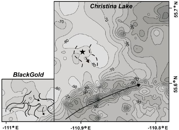
Paleotopography on the sub-Cretaceous unconformity surface in the Christina Lake and the BlackGold Lease areas. The location of the studied core is marked with a star. Contours in meters represent the depths of the unconformity surface, measured from the top of the Wabiskaw Member (datum). Thick solid lines in the BlackGold Lease area show river systems defined by the distribution of thick channel-sandstone bodies at 61 m below the datum. Dashed lines in the Christina Lake area indicate a inferred tributary river system at the core location. Major river systems developed toward ENE along the paleovalley in the southern part of Christina Lake area.
시추 코어에서 연구된 약 1.4 m 두께의 이암층 구간은 맥머레이층의 바닥으로부터 약 20 m 상부에 분포한다(그림 4a). 이 위치에서 맥머레이층의 전체 두께는 60 m이며, 연구된 이암층 구간은 중부 맥머레이층에 속한다. 이 이암층들은 사암이 우세한 시퀀스 내에 발달하는데, 무구조 또는 엽층리의 이암으로 구성되고, 이암편 각력암, 괴상의 사암, 평행엽층리와 사엽층리의 사암 등과 함께 산출한다(그림 4b, 4c, 4d). 사암과 이암은 다양한 규모로 교호하는데, 수 cm~수 십 cm 두께의 층단위로 교호하기도 하고 엽층단위로 교호하기도 한다. 평행엽층리 또는 사엽층리의 사암은 이암엽층을 흔히 포함한다(그림 4c, 4d). 이러한 특징은 이질경사층리(inclined heterolithic stratification; IHS)의 대표적 특징인데, 이는 중부 맥머레이층의 조석영향을 받은 사행하천의 포인트바(point bar) 퇴적층을 지시한다(Mossop and Flach, 1983; Flach, 1984; Hein et al., 2000; Hubbard et al., 2011; Musial et al., 2012; Nardin et al., 2013; Shinn et al., 2014). 이암편 각력암은 사행하천의 횡적 이동으로 둑이 침식되어 공급된 이암편이 하상에 퇴적되어 형성되었다(Mossop and Flach, 1983; Hein et al., 2000; Hubbard et al., 2011; Musial et al., 2012). 함께 산출하는 퇴적상을 바탕으로, 연구된 이암층들은 조석 영향을 받은 사행하천의 포인트바에서 퇴적된 것으로 해석된다.
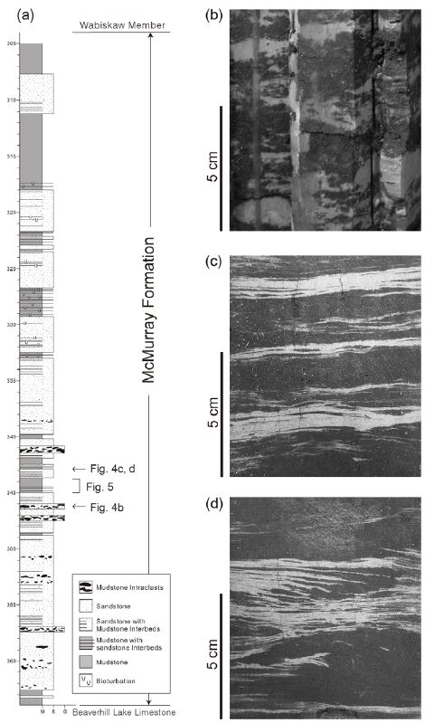
(a) Columnar log of core 6-5-77-6. The studied mudstone beds (Fig. 5) occur in the middle McMurray Formation. These mudstone beds are associated with various sedimentary facies indicating deposition in tidally-influenced meandering channels. (b) Mudstoneintraclast breccia with bitumen-stained (black) sandstone matrix. (c) Interbedded sandstones (black) and mudstones with heterolithic laminations. (d) Ripple cross-laminated and parallel-laminated sandstones with heterolithic laminations.
3. 이암층의 퇴적상 분석
본 연구의 이암층들은 육안으로 관찰할 경우 대개 무구조의 이암층으로 구성되고 일부 엽층을 포함하는 것으로 인지되나, 박편을 제작하여 현미경으로 자세히 관찰한 결과 무수히 많은 층리가 발견된다. 조직과 내부층리 등의 퇴적구조를 기반으로 총 3개의 미퇴적상(microfacies)으로 분류하였다. 각 미퇴적상은 1 mm 이하에서 수 cm 두께의 층을 형성하며, 점이적 또는 선명한 경계를 가지고 서로 수직적으로 변화하는 관계를 보인다(그림 5). 본 연구에서 정의된 미퇴적상은 대부분 1 cm 이하인 엽층의 두께를 가지므로 야외조사 연구에 적용되는 기존의 퇴적상 분류 방법으로 구분되지 않는다. 현미경으로 관찰할 수 있는 특징으로부터 구분되었기에 미퇴적상으로 정의하였다. 미퇴적상들은 입자점이(grading)를 보이지 않고 흔히 산발적으로 분포하는 조립질 입자들을 포함하는 특징을 가지므로 부유 퇴적물의 침강이 아닌 고농도 이토류에 의해 퇴적된 것으로 해석된다(Ichaso and Darlymple, 2009; Mackay and Darlymple, 2011). 또한 생물교란구조가 거의 없으므로 이토가 조용한 환경에서 서서히 가라앉아 퇴적된 것이 아니라 비교적 빠르게 활발히 퇴적된 것으로 보인다(Mackay and Darlymple, 2011).
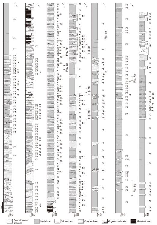
Detailed columnar logs of mudstone layers. Microfacies codes of the mudstone layers are presented on the right of columns.
3.1 미퇴적상 1: 무구조 이암(Structureless Mudstone)
이 퇴적상은 무구조(structureless)의 이암으로 3 mm에서 최대 25 mm의 두께이며, 평균 10 mm의 두께를 가진다. 기질은 주로 점토 입자로 구성되는데, 균질하지 않고 입자질 조직(grainy texture; Plint, 2014)을 보인다(그림 6a). 조립질 실트(coarse silt)에서 세립질 모래(fine sand) 크기의 조립질 입자들이 이 이암층 전체에 산발적으로 분포하며, 다량의 납작한 유기물 파편이 층리면과 평행하게 배열되어 있다(그림 6a, 6b). 또한, 불연속적이고 매우 얇은 조립질 실트엽층(silt streak)이 이암층의 하부에 드물게 분포한다. 이 퇴적상은 미퇴적상 2와 점이적인 경계를 보이지만, 미퇴적상 3과는 선명한 경계를 가진다(그림 6c). 특히 미퇴적상 3 아래에 놓일 경우 하중구조(load structure)가 상부면에 흔히 발달하며(그림 6c), 미퇴적상 3이 두꺼운 미퇴적상 1과 함께 산출될 경우 미퇴적상 3은 흔히 변형되어 나타난다.
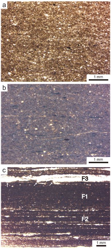
Micrographs of structureless mudstone (Microfacies 1). (a) Grainy texture of clay matrix and dispersed coarser grains. (b) Coarser grains (coarse silt to fine sand) and flat organic materials (black) are randomly scattered throughout clay matrix. (c) Microfacies 1 (F1) overlying Microfacies 2 (F2) with a transitional boundary and overlain by Microfacies 3 (F3) with a sharp boundary. Load structures (arrows) at the base of Microfacies 3.
이 퇴적상은 입도점이와 내부층리의 부재, 산재해 분포하는 다량의 조립질 입자들을 포함한 특징으로 보아 점착성 이토류, 즉 유성이토에 의해 퇴적되었을 것으로 해석된다(Soyinka and Slatt, 2008; Ichaso and Dalrymple, 2009; Mackay and Dalrymple, 2011; Plint, 2014; Hovikoski et al., 2016). 흐름의 감속으로 인해 부유점토 농도가 증가하면, 점토 입자 표면의 정전기력에 의해 서로 끌어당겨 floc을 형성한다(Wang and Larsen, 1994; Baas and Best, 2002; Plint, 2014). 고농도의 점토 부유물에서 형성된 floc으로 퇴적되었기에 입자질 조직이 나타나며(Plint, 2014), 이러한 floc 또는 점착성 점토입자들은 흐름 전체의 난류를 억제하여 plug를 형성한다(Baas and Best, 2002; Bass et al., 2009). 층리면에 평행하게 배열된 유기물 파편은 plug 내의 층상 전단작용(laminar shearing)을 제시한다. 이는 plug 위를 흐르는 흐름에 의해 전단 응력(shear stress)이 가해져 발생할 수 있다. 이 퇴적상의 하부에 드물게 나타나는 실트엽층은 quasi-laminar plug flow 또는 upper transitional plug flow의 기저부에서 짧은 시간동안 발생하는 약한 난류에 의해 형성될 수 있다(Baas and Best, 2002; Baas et al., 2009). 함께 산출하는 미퇴적상 3에서 흔히 나타나는 하중구조와 변형구조는 유성이토의 높은 물 함유량 때문으로 생각된다. 전반적으로 난류의 부재와 점착성을 지시하는 특징으로 보아 미퇴적상 1을 형성한 유성이토는 quasi-laminar plug flow 상태에서 퇴적되었을 것으로 해석된다.
3.2 미퇴적상 2: 실트엽층을 포함하는 이암 (Silt-Streaked Mudstone)
이 미퇴적상은 얇은 실트엽층을 포함하는 이암으로, 2~10 mm 정도의 두께를 가지며, 퇴적층들이 중첩될 경우 최대 25 mm 두께를 보인다(그림 7). 미퇴적상 2 또한 입자질 조직을 보이며, 산재해 있는 중립질 실트~세립질 모래 입자와 층리면에 평행하게 배열된 납작한 유기물 파편을 포함하여 미퇴적상 1의 조직과 매우 흡사하다(그림 7a). 실트엽층은 1 mm 이하의 두께이며, 주로 조립질 실트에서 미세립질 모래 크기의 석영 입자로 구성된다. 이 실트엽층들은 층리와 평행하며 불연속적이지만 박편 전체 너비에 걸쳐 횡적으로 서로 이어진다. 미퇴적상 2가 미퇴적상 3 아래에 놓이는 경우에는 대개 뚜렷한 경계면을 가지지만, 일부 연장성이 좋은 실트엽층들이 미퇴적상 2의 상부에 산출하면 점이적 경계를 보이기도 한다(그림 7b). 미퇴적상 1과 함께 산출할 경우, 경계는 점이적이다(그림 6c).
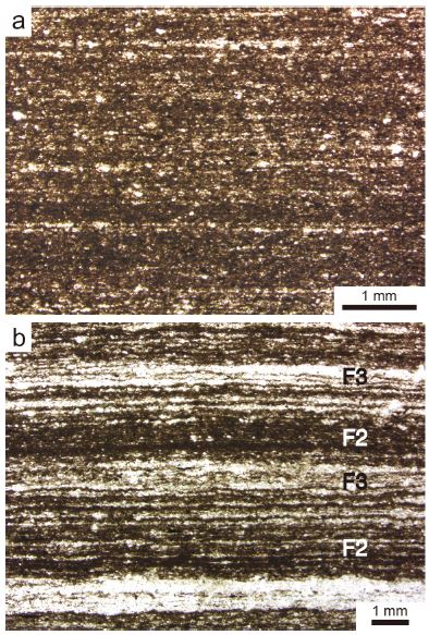
Micrographs of silt-streaked mudstone (Microfacies 2). (a) Grainy texture and thin, discontinuous streaks consisting of coarse-silt to very-fine-sand grains. (b) Alternations of Microfacies 2 (F2) and 3 (F3). F2 shows an upward increase in thickness and proportion of silt laminae and changes to silt-dominant F3.
미퇴적상 2 또한 입자점이의 부재, 무질서하게 분포된 조립질 입자, 입자질 조직의 특징을 보이므로 유성이토 퇴적층으로 해석된다(Plint, 2014; Hovikoski et al., 2016). 실트엽층은 plug 아래에서 간헐적으로 발생하는 난류에 의해 점착성 부유 이토로부터 조립질 입자가 분리되어 형성되었다. upper transitional plug flow 또는 quasi-laminar plug flow에서 점착력이 난류를 억제하지만 완전히 억제되지 않고 바닥 근처에 약한 난류가 잔류할 수 있다(Baas and Best, 2002; Baas et al., 2009, 2011). 난류에 의해 분리된 실트 입자들은 밑짐으로 이동하여 실트엽층을 형성할 수 있다. 하지만 floc의 높은 퇴적률로 인해 짧은 거리를 움직이고 묻히기 때문에 불연속적인 실트엽층이 형성되는 것으로 해석된다(Baas et al., 2016).
3.3 미퇴적상 3: 이질 엽층리 이암 (Heterolithic Laminated Mudstone)
미퇴적상 3은 1 mm 이하의 아주 얇은 실트엽층과 점토엽층의 교호로 구성되며, 1~6 mm 두께의 엽층짝(lamina-set)을 형성한다(그림 7b, 8). 실트엽층은 조립질 실트에서 미세립질 모래 크기의 입자로 구성되며, 점토엽층보다 상대적으로 두껍다. 점토엽층은 실트엽층보다 훨씬 얇은 두께이며, 점토 입자가 우세한 가운데 실트 입자가 산재해 있다. 부분적으로 실트엽층과 점토엽층이 비슷한 두께를 보이기도 한다. 엽층짝은 평행엽층리(parallel-lamination) 또는 저각도 사엽층리(low-angle cross-lamination)를 보이며, 가끔 s자 모양(sigmoidal)의 이질 사엽층리를 이루는 낮은 연흔(low-amplitude ripple)이 관찰된다(그림 8a, 8b, 8c). 이 미퇴적상의 일부 층은 2~3개의 엽층짝이 수직적으로 중첩되어 구성되는데, 이들은 엽층 형태의 미세한 차이로 구분된다. 일부 저각도 사엽층리의 층은 렌즈상으로 산출하며, 미퇴적상 2의 퇴적층 내에 협재한다(그림 8c). 엽층들은 층의 하부에서 대체로 수직적으로 누적된 형태를 보이고, 최상부에서는 횡적으로 중첩되어 저각도 사엽층리를 형성하는데, 최상부에서 실트엽층의 비율이 가장 높다(그림 8a, 8b). 이러한 사엽층리는 상부에 선명한 경계면을 가지며, 아래로 오목한 얕은 침식면이 상부 경계에 흔히 발달한다(그림 8b). 하부 경계 또한 대개 선명하지만 아래에 미퇴적상 2가 놓이는 경우에 점이적 관계를 보이기도 한다. 이 미퇴적상이 미퇴적상 1 위에 놓이면 하중구조가 흔히 발달하고(그림 6c), 두꺼운 미퇴적상 1과 함께 산출될 경우 대부분 변형되어 있다(그림 8c).
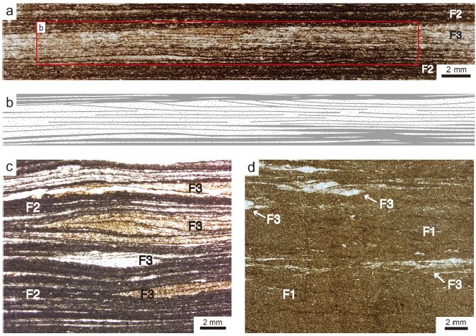
Micrographs of heterolithic laminated mudstone (Microfacies 3). (a) Alternations of silt laminae and thin clay laminae in Microfacies 3 (F3). (b) A sketch of silt and clay laminae in Microfacies 3. Note that the laminae are stacked vertically in the lower part and change to be stacked laterally in the uppermost part, forming low-angle cross-lamination. The sharp upper boundary of Microfacies 3 includes shallow scour surfaces. (c) Low-angle cross-lamination and low-amplitude ripple forms of Microfacies 3 (F3). (d) Deformed layers of Microfacies 3 (F3) associated with relatively thick Microfacies 1 (F1).
점착성 이토류 퇴적층과 관련되어 산출되는 이 퇴적상은 점착성 plug 아래에서 전단 분급(shear sorting)에 의해 형성된 것으로 해석된다(Mackay and Dalrymple, 2011; Plint, 2014; Hovikoski et al., 2016). 부유 점토 농도가 증가함에 따라 난류는 전이적 흐름으로 변하는데, 이 때 점착성 plug가 형성되고 그 아래에는 난류층(turbulent zone)이 발달한다(Baas and Best, 2002; Baas et al., 2009). plug와 난류층의 경계면에서 발생하는 Kelvin-Hemholtz 불안정성으로 인해 난류층 내에 속도 변동이 일어나고, 이로 인해 실트와 점토 입자의 퇴적이 교대로 일어날 수 있다(Baas and Best, 2002; Mackay and Dalrymple, 2011).
이 퇴적상의 이질 엽층리는 lower transitional plug flow 상태에서 형성되는 낮은 bed-wave 또는 연흔의 퇴적구조와 유사한 특징을 보인다(Baas et al., 2016). 퇴적층 하부에서 상부로 갈수록 엽층들이 수직누적형에서 횡적중첩 형태로 변하는 특징과 실트엽층의 비율 증가는 lower transitional plug flow (LTPF)에서 점토 농도 증가에 따른 바닥 근처의 난류 강도 증가에 기인한 것으로 해석된다(Baas et al., 2009, 2011, 2016). 상대적으로 낮은 농도의 LTPF에서는 부유 퇴적물의 높은 침강률로 인해 층면구조의 수직적 누적이 우세하다(Baas et al., 2016). 하지만 비교적 높은 농도의 LTPF에서는 강한 난류로 인해 점토 입자의 침강이 저하되고 바닥의 퇴적물이 침식되어 재동한다(Baas et al., 2011, 2016). 바닥 퇴적물 중 점토 floc은 강한 난류에 의해 쉽게 부서져 재부유할 수 있고, 실트 입자들은 침식된 후 하류로 이동하여 실트가 우세한 낮은 bed-wave를 형성한다. 이러한 bed-wave는 부유 퇴적물의 낮은 침강률과 바닥 퇴적물의 활발한 재동으로 인해 주로 횡적으로 이동하여 횡적으로 중첩된 사엽층리를 형성할 것이다. 이 퇴적상 상부의 침식면과 그와 관련되어 침식면의 하류 방향에 형성된 저각도 사엽층리는 LTPF 아래에서 퇴적물이 강한 난류에 의해 침식되어 침식면의 하류에 낮은 bed-wave로 재퇴적되었음을 제시한다.
4. 토 의
조석환경, 특히 염하구 환경은 부유 이토가 풍부한 대표적인 곳이다. 홍수 시 인근의 강으로부터 많은 양의 이토가 공급되고, 조류와 해류에 의해 외해로부터 이토가 유입되고, 바닥에 가라앉은 이토가 파랑에 의해 재부유되어 수중에 부유 이토가 풍부하다. 부유 이토는 강물과 바닷물이 섞이는 지역에서 최고농도를 보이는데, 흔히 조석영향을 받는 염하구 사행하도에서 최고 탁도(turbidity maximum)를 형성한다(Allen et al., 1980; Dyer, 1995; Dalrymple and Choi, 2003, 2007). 고농도의 부유 이토는 조류가 약할 때 또는 정조기에 floc으로 빠르게 가라앉아 유성이토를 형성한다(Dalrymple and Choi, 2007; McAnally et al., 2007). 이런 작용을 통해 염하구 환경에서 유성이토는 흔히 발달한다. 하지만 고생의 염하구 퇴적층에서 유성이토가 연구된 예는 매우 드물다(e.g., Ichaso and Dalrymple, 2009; Mackay and Dalrymple, 2011).
맥머레이층의 중부 퇴적층은 조석영향을 받는 하천 또는 염하구에서 형성된 것으로 해석된다(Mossop and Flach, 1983; Flach, 1984; Flach and Mossop, 1985; Crerar and Arnott, 2007; Hubbard et al., 2011; Musial et al., 2012). 맥머레이 중부 퇴적층 내에 유성이토층이 퇴적되었을 가능성이 많음에도 불구하고, 아직 보고된 바가 없다. 중부 퇴적층 내에 산출하는 비교적 두꺼운 이암층(수 m~30 m)은 얇은 사암층들을 포함하고 생물교란을 받은 특징을 보이는데, 유기된 하도(abandoned channel) 또는 범람원과 같은 조용한 환경에서 부유 이토가 천천히 침강하여 퇴적된 것으로 해석된다(Hein et al., 2000; Hubbard et al., 2011; Musial et al., 2012; Shinn et al., 2014). 조석영향을 받는 사행하도의 포인트바 퇴적층에도 이암층이 사암층과 함께 이질경사층리(inclined heterolithic stratification)를 형성하며 산출한다. 이 중 사엽층리 사암층을 피복하는 수 mm 두께 이하의 매우 얇은 이암층은 정조기에 부유 이토가 가라앉아 퇴적된 것으로 해석된다(Hein et al., 2000; Hubbard et al., 2011; Musial et al., 2012; Shinn et al., 2014). 이질경사층에서 비교적 두꺼운 이암층은 하천류의 계절적인 변화와 관련되어 형성되었을 것으로 추정되나(Hein et al., 2000; Hubbard et al., 2011; Musial et al., 2012; Shinn et al., 2014), 홍수 시 유입된 많은 양의 이토가 부유 침강 또는 유성이토에 의해 퇴적되었는지 명확히 해석되지 않았다.
염하구 퇴적층에서 보고된 유성이토층이 드물지만, 캐나다의 전기 백악기 블루스카이층(Bluesky Formation)에서 연구된 예가 있다(Mackay and Dalrymple, 2011). 블루스카이층은 맥머레이층과 마찬가지로, 서캐나다분지(Western Canada Basin)에서 해침이 일어나는 동안 염하구 환경에서 퇴적되었다. 조류의 유속이 감소하고 바닥의 부유 점토 농도가 증가하면서 transitional plug flow가 형성되고, plug 아래에서 이질층리의 이암층(heterolithic stratified mudstone)이 퇴적되었다(Mackay and Dalrymple, 2011). 유속이 더 감소하고 부유 점토 농도가 더 증가함에 따라 흐름은 quasi-laminar plug flow로 변하였고, 결국 plug 전체가 정지하면서 무층리의 이암층(unstratified mudstone)이 형성되었다(Mackay and Dalrymple, 2011). 블루스카이층의 유성이토층은 퇴적환경 및 퇴적상에 있어, 본 연구에서 제시된 맥머레이층의 유성이토층과 매우 유사하다.
그동안 유성이토 퇴적층에 대한 연구가 드물었던 것은 유성이토의 유동특성과 퇴적현상에 대한 이해가 부족했기 때문이다. 최근 일련의 실험 연구들을 통해 고농도의 부유점토를 함유한 흐름의 유동역학과 퇴적물 거동에 대한 이해가 크게 향상되었다(Baas and Best, 2002; Baas et al., 2009, 2011, 2016). 이러한 실험연구의 결과를 토대로, 대륙붕, 심해, 호수 등에서 형성된 퇴적층에서 세립질 퇴적물 중력류에 의해 퇴적된 이암층들을 보다 상세히 또는 새롭게 해석할 수 있었다(Soyinka and Slatt, 2008; Ghadeer and Macquaker, 2011; Plint, 2014; Hovikoski et al., 2016). 염하구 퇴적층에서도 유성이토에 의해 형성된 이암층의 퇴적학적 특징이 새로이 규명될 수 있었다(Mackay and Dalrymple, 2011). 앞에서 토의되었듯이, 염하구 환경은 유성이토가 발달할 수 있는 좋은 조건을 갖추고 있기 때문에 고기의 염하구 퇴적층에 유성이토층이 흔히 분포하리라 예상된다. 서캐나다분지의 블루스카이층과 본 연구의 맥머레이층에서 규명된 유성이토 퇴적층의 특징은 다른 여러 퇴적분지에서 유성이토층을 인지하고 연구하는데 밑거름이 되리라 생각된다.
5. 결 론
캐나다 앨버타주 맥머레이층의 중부 퇴적층은 염하구 환경에서 조석 영향을 받은 하도에서 형성된 퇴적층으로 주로 구성된다. 이러한 하도 퇴적층 내에 다양한 두께의 이암층이 분포하는데, 이들은 겉으로 보이는 것과 달리 현미경하에서 무수히 많은 얇은 층리와 미세한 퇴적구조를 보인다. 이암층의 조직과 퇴적구조를 기준으로 3개의 미퇴적상(microfacies)을 구분하였다. 각 퇴적상은 1 mm 이하에서 수 cm 두께의 층을 이루고 수직적으로 서로 인접하여 나타난다. 미퇴적상 1은 점토 기질에 조립질 실트에서 세립질 모래 크기의 조립질 입자가 무질서하게 분포하는 무구조의 이암이며, 미퇴적상 2는 미퇴적상 1과 마찬가지로 조립질 입자를 포함하는 이암으로 구성되나 불연속적인 매우 얇은 실트엽층을 포함한다. 미퇴적상 3은 실트엽층과 점토엽층이 교호하는 이질 엽층으로 구성되고, 평행엽층리 또는 저각도 사엽층리를 보인다. 이 퇴적상들은 고농도의 부유 이토가 점착성 plug를 형성한 흐름, 즉 유성이토에 의해 퇴적된 것으로 해석되는데, 각각 quasi-laminar plug flow, upper transitional plug flow, lower transitional plug flow에서의 퇴적을 나타낸다. 그 동안 고생의 염하구 퇴적층에서 유성이토층이 드물게 보고되었지만, 서캐나다분지의 블루스카이층에서 연구된 예와 본 연구의 맥머레이층에서 규명된 유성이토층의 퇴적상은 다른 지역의 퇴적층에서 유성이토층을 인지하고 연구하는데 중요한 기여를 할 것이다.
Acknowledgments
이 논문은 안동대학교 기본연구지원사업에 의하여 연구되었습니다. 심사과정에서 논문에 대해 유익한 의견을 주신 익명의 두 분 심사위원께 감사드립니다.
REFERENCES
- Alberta Energy and Utilities Board (AEUB), (2007), Alberta’s Energy Reserves 2006 and Supply/Demand Outlook 2007-2016, ST98-2007, Alberta Energy and Utilities Board, Calgary, p218.
-
Allen, G.P., Salomon, J.C., Bassoullet, P., Du Penhoat, Y., and De Grandpré, C., (1980), Effects of tides on mixing and suspended sediment transport in macrotidal estuaries, Sedimentary Geology, 26, p69-90.
[https://doi.org/10.1016/0037-0738(80)90006-8]

-
Baas, J.H., and Best, J.L., (2002), Turbulence modulation in clay-rich sediment-laden flows and some implications for sediment deposition, Journal of Sedimentary Research, 72, p336-340.
[https://doi.org/10.1306/120601720336]

-
Baas, J.H., Best, J.L., and Peakall, J., (2011), Depositional processes, bedform development and hybrid bed formation in rapidly decelerated cohesive (mud-sand) sediment flows, Sedimentology, 58, p1953-1987.
[https://doi.org/10.1111/j.1365-3091.2011.01247.x]

-
Baas, J.H., Best, J.L., and Peakall, J., (2016), Predicting bedforms and primary current stratification in cohesive mixtures of mud and sand, Journal of the Geological Society, London, 173, p12-45.
[https://doi.org/10.1144/jgs2015-024]

-
Baas, J.H., Best, J.L., Peakall, J., and Wang, M., (2009), A phase diagram for turbulent, transitional, and laminar clay suspension flows, Journal of Sedimentary Research, 79, p162-183.
[https://doi.org/10.2110/jsr.2009.025]

- Cant, D.J., (1996), Sedimentological and sequence stratigraphic organization of a foreland clastic wedge, Mannville Group, Western Canada Basin, Journal of Sedimentary Research, 66, p1137-1147.
-
Crerar, E.E., and Arnott, R.W.C., (2007), Facies distribution and stratigraphic architecture of the Lower Cretaceous McMurray Formation, Lewis Property, northeastern Alberta, Bulletin of Canadian Petroleum Geology, 55, p99-124.
[https://doi.org/10.2113/gscpgbull.55.2.99]

- Dalrymple, R.W., and Choi, K.S., (2003), Sediment transport by tidal currents, In: Middleton, G.V. (ed.), Encyclopedia of Sediments and Sedimentary Rocks, Kluwer Academic Publishers, Dordrecht, p606-609.
-
Dalrymple, R.W., and Choi, K.S., (2007), Morphologic and facies trends through the fluvial-marine transition in tide-dominated depositional systems: a schematic framework for environmental and sequence-stratigraphic interpretation, Earth-Science Reviews, 81, p135-174.
[https://doi.org/10.1016/j.earscirev.2006.10.002]

- Dyer, K.R., (1995), Sediment transport processes in estuaries, In: Perillo, G.M.E. (ed.), Geomorphology and Sedimentology of Estuaries, Elsevier, Amsterdam, p423-449.
- Flach, P.D., (1984), Oil Sands Geology-Athabasca deposit north, Bulletin 46, Alberta Research Council, Edmonton, p31.
- Flach, P.D., and Mossop, G.D., (1985), Depositional environments of Lower Cretaceous McMurray Formation, Athabasca oil sands, Alberta, The American Association of Petroleum Geologists Bulletin, 69, p1195-1207.
-
Ghadeer, S.G., and Macquaker, J.H.S., (2011), Sediment transport processes in an ancient mud-dominated succession: a comparison of processes operating in marine offshore settings and anoxic basinal environments, Journal of the Geological Society, London, 168, p1121-1132.
[https://doi.org/10.1144/0016-76492010-016]

- Hein, F.J., (2015), The Cretaceous McMurray oil sands, Alberta, Canada: a world-class, tidally influenced fluvial-estuarine system-an Alberta government perspective, In: Ashworth, P.J, Best, J.L., and Parsons, D.R. (eds.), Fluvial-Tidal Sedimentology, Developments in Sedimentology, 68, Elsevier, Amsterdam, p561-621.
-
Hein, F.J., and Cotterill, D.K., (2006), The Athabasca oil sands-a regional geological perspective, Fort McMurray area, Alberta, Canada, Natural Resources Research, 15, p85-102.
[https://doi.org/10.1007/s11053-006-9015-4]

- Hein, F.J., Cotterill, D.K., and Berhane, H., (2000), An Atlas of Lithofacies of the McMurray Formation, Athabasca Oil Sands Deposit, Northeastern Alberta: Surface and Subsurface, Earth Sciences Report 2000-07, Alberta Energy and Utilities Board/Alberta Geological Survey, Edmonton, p216.
-
Hovikoski, J., Therkelsen, J., Nielsen, L.H., Bojesen-Koefoed, J.A., Nytoft, H.P., Petersen, H.I., Abatzis, I., Tuan, H.A., Phuong, B.T.N., Dao, C.V., and Fyhn, M.B.W., (2016), Density-flow deposition in a fresh-water lacustrine rift basin, Paleogene Bach Long Vi Graben, Vietnam, Journal of Sedimentary Research, 86, p982-1007.
[https://doi.org/10.2110/jsr.2016.53]

-
Hubbard, S.M., Smith, D.G., Nielsen, H., Leckie, D.A., Fustic, M., Spencer, R.J., and Bloom, L., (2011), Seismic geomorphology and sedimentology of a tidally influenced river deposit, Lower Cretaceous Athabasca oil sands, Alberta, Canada, American Association of Petroleum Geologists Bulletin, 95, p1123-1145.
[https://doi.org/10.1306/12131010111]

-
Ichaso, A.A., and Dalrymple, R.W., (2009), Tide-and wave-generated fluid mud deposits in the Tilje Formation (Jurassic), offshore Norway, Geology, 37, p539-542.
[https://doi.org/10.1130/g25481a.1]

- Jo, H.R., and Ha, C.G., (2013a), Stratigraphic architecture of fluvial deposits of the Cretaceous McMurray Formation, Athabasca oil sands, Alberta, Canada, Geosciences Journal, 17, p417-427.
- Jo, H.R., and Ha, C.G., (2013b), Basal water-bearing zone of the oil-sands deposits of the Cretaceous McMurray Formation at Christina Lake, Alberta, Canada, Geosciences Journal, 17, p445-453.
- Leckie, D.A., and Smith, D.G., (1992), Regional setting, evolution, and depositional cycles of the Western Canada foreland basin, In: Macqueen, R.W., and Leckie, D.A. (eds.), Foreland Basins and Fold Belts, American Association of Petroleum Geologists, Memoir, 55, p9-46.
- Lee, H.S., Park, C.H., Shinn, Y.J., Lee, H.Y., Jeong, S.H., Hong, S.K., Yang, I.H., Kim, G.H., Shin, H., Rhee, C.W., Park, E.K., Jeong, J.A., and Jo, H.R., (2015), Technology in Oil Sands Development, Korea Institute of Geoscience and Mineral Resources, p240, (in Korean).
-
Mackay, D.A., and Dalrymple, R.W., (2011), Dynamic mud deposition in a tidal environment: the record of fluid-mud deposition in the Cretaceous Bluesky Formation, Alberta, Canada, Journal of Sedimentary Research, 81, p901-920.
[https://doi.org/10.2110/jsr.2011.74]

-
McAnally, W.H., Friedrichs, C., Hamilton, D., Hayter, E., Shrestha, P., Rodriguez, H., Sheremet, A., and Teeter, A., (2007), Management of fluid mud in estuaries, bays, and lakes. I: present state of understanding on character and behavior, Journal of Hydraulic Engineering, 133, p9-22.
[https://doi.org/10.1061/(asce)0733-9429(2007)133:1(9)]

-
Mossop, G.D., and Flach, P.D., (1983), Deep channel sedimentation in the Lower Cretaceous McMurray Formation, Athabasca Oil sands, Alberta, Sedimentology, 30, p493-509.
[https://doi.org/10.1111/j.1365-3091.1983.tb00688.x]

-
Musial, G., Reynaud, J.-Y., Gingras, M.K., Féniès, H., Labourdette, R., and Parize, O., (2012), Subsurface and outcrop characterization of large tidally influenced point bars of the Cretaceous McMurray Formation (Alberta, Canada), Sedimentary Geology, 279, p156-172.
[https://doi.org/10.1016/j.sedgeo.2011.04.020]

- Nardin, T.R., Feldman, H.R., and Carter, B.J., (2013), Stratigraphic architecture of a large-scale point-bar complex in the McMurray Formation: Syncrude’s Mildred Lake Mine, Alberta, Canada, In: Hein, F.J., Leckie, D., Larter, S., and Suter, J.R. (eds.), Heavy-Oil and Oil-Sand Petroleum Systems in Alberta and Beyond, AAPG Studies in Geology, 64, p273-311.
- Plint, A.G., (2014), Mud dispersal across a Cretaceous prodelta: storm-generated, wave-enhanced sediment gravity flows inferred from mudstone microtexture and microfacies, Sedimentology, 61, p609-647.
- Ranger, M.J., and Pemberton, S.G., (1997), Elements of a stratigraphic framework for the McMurray Formation in south Athabasca area, Alberta, In: Pemberton, S.G., and James, D.P. (eds.), Petroleum Geology of the Cretaceous Mannville Group, Western Canada, Canadian Society of Petroleum Geologists, Memoir, 18, p263-291.
-
Shinn, Y.J., Lee, H.S., Kwon, Y.K., and Kwak, W.J., (2014), Lithofacies distribution and depositional environment in the Lower Cretaceous McMurray Formation, BlackGold Lease, northern Alberta: implications for geometry and distribution of oil sand reservoirs, Geosciences Journal, 18, p325-337.
[https://doi.org/10.1007/s12303-014-0006-x]

- Soyinka, O.A., and Slatt, R.M., (2008), Identification and micro-stratigraphy of hyperpycnites and turbidites in Cretaceous Lewis Shale, Wyoming, Sedimentology, 88, p1117-1133.
- Stockmal, G.S., Cant, D.J., and Bell, J.S., (1992), Relationship of the stratigraphy of the Western Canada foreland basin to Cordilleran tectonics: insights from geodynamic models, In: Macqueen, R.W., and Leckie, D.A. (eds.), Foreland Basins and Fold Belts, American Association of Petroleum Geologists, Memoir, 55, p107-124.
-
Talling, P.J., Masson, D.G., Sumner, E.J., and Malgesini, G., (2012), Subaqueous sediment density flows: depositional processes and deposit types, Sedimentology, 59, p1937-2003.
[https://doi.org/10.1111/j.1365-3091.2012.01353.x]

-
Wang, Z., and Larsen, P., (1994), Turbulent structure of water and clay suspensions with bed load, Journal of Hydraulic Engineering, 120, p577-600.
[https://doi.org/10.1061/(asce)0733-9429(1994)120:5(577)]

- Wightman, D.M., and Pemberton, S.G., (1997), The Lower Cretaceous (Aptian) McMurray Formation: an overview of the Fort McMurray area, northeastern Alberta, In: Pemberton, S.G., and James, D.P. (eds.), Petroleum Geology of the Cretaceous Mannville Group, Western Canada, Canadian Society of Petroleum Geologists, Memoir, 18, p312-344.
