경상분지 남부 고성층의 분포, 퇴적시기와 구조진화사
초록
유천층군 최하부의 고성층은 하양층군 최상부의 진동층을 평행부정합으로 피복하고 있으며, 유천층군 안산암류와 불국사화강암류에 의해 피복 또는 관입되어 있다. 이번 연구에서는 경남 고성군 일원을 중심으로 상세 야외지질조사를 수행하여 고성층의 정확한 분포 특성과 구조진화사를 해석하였으며 절대연대측정을 통한 퇴적시기를 제안하였다. 고성층은 하위의 진동층과 달리 자색층과 다량의 응회질 물질을 포함하는데, 주로 자색 이암 내지 사암, 녹회색 사암, 응회질 퇴적암으로 구성되며 국부적으로 암회색 이암, 역질 사암, 역암이 협재하기도 한다. 고성층의 퇴적시기를 한정하기 위하여 상부 고성층에 협재하는 데사이트질 화산회응회암과 고성층을 피복하는 안산암질 화산회응회암에 실시한 LA-MC-ICPMS 저어콘 U-Pb 절대연령측정 결과는 각각 약 89 Ma와 약 85 Ma가 도출되었으며, 이를 기존 연구결과에서 제시된 하부 고성층 내 데사이트질 응회암의 SHRIMP 저어콘 U-Pb 연대(약 92 Ma)와 종합하면 고성층의 퇴적은 92 Ma 이전에 시작되어 85 Ma 이전에 종결된 것으로 판단된다. 한편 고성층은 전반적으로 남쪽으로 경사진 경향을 보이나, 고성층 서편의 지층은 동 내지 남동쪽으로 경사지고 일부 지점에서는 후기 단층운동과 화성활동의 영향으로 교란된 양상이 확인된다. 고성층 내부에서 흔히 관찰되는 서북서 방향 성장단층들은 점완/서가형 또는 공액상의 기하를 가지며 일부 단층면에서는 정이동성 감각의 조선이 인지되지만, 남-북 방향 성장단층에서는 좌수향 횡인장성 사교이동감각이 관찰된다. 5 cm 이내 두께의 쇄설성 암맥 또한 성장단층과 유사하게 북서 내지 서북서 방향이 주를 이룬다. 고성층을 절단하는 퇴적된 이후의 단층들은 주로 남-북 방향과 북서 내지 서북서 방향이 가장 우세하고 대부분이 3 cm 이내의 폭을 갖는 좁은 띠를 따라 전단이 집중된다. 다양한 구조요소들의 선후관계에 근거할 때, 고성층은 백악기말 북북동-남남서 내지 북동-남서 인장력 하에서 퇴적된 이후 북서-남동 최대수평응력/북동-남서 최소수평응력 하에 놓여있었으며, 이후 고신생기초 중성질 암맥군의 관입과 약 44 Ma 이후 작동된 북동-남서 최대수평응력/북서-남동 최소수평응력 하에서 변형되었다. 마지막으로 제4기 동-서 압축력 하에서는 기존의 구조적 약대가 선택적으로 재활동한 것으로 해석된다.
Abstract
The Goseong Formation, the lowermost formation of the Yucheon Group, disconformably overlies the Jindong Formation, which is the uppermost formation of the Hayang Group, and is overlain and intruded by the andesitic rocks of the Yucheon Group and the Bulguksa Granites. We revealed the distribution and structural evolution of the formation based on detailed geological mapping and structural analysis and constrained its depositional age range based on absolute age dating methods. The formation is characterized by purple strata and a vast amount of volcanic materials, unlike the Jindong Formation. It is composed mainly of the purple mudstones and sandstones, greenish sandstones, tuffaceous sedimentary rocks, which are intercalated with dark gray mudstones, pebbly sandstones, and conglomerates. In order to constrain the depositional age of Goseong Formation, LA-MC-ICPMS U-Pb zircon ages obtained from the tuffs within and overlying the upper Goseong Formation are ca. 89 Ma and ca. 85 Ma, respectively. Considering the SHRIMP U-Pb zircon age (ca. 92 Ma) of the dacitic tuff within the lower Goseong Formation from a previous study, the Goseong Formation indicate that its accumulation commenced before 92 Ma and terminated before 85 Ma. Meanwhile, the stratal attitudes generally define a homoclinal structure dipping toward the south. But the strata in the western part of the formation dip toward the east or southeast with their local deflections due to post-faulting and volcanic activity. The WNW-striking growth faults observed in the Goseong Formation have listric/domino or conjugate geometries and sometimes show normal-slip senses, whereas the N-S-striking growth faults mostly show sinistral transtensional oblique-slip senses. The directions of clastic dykes (< 5 cm in thickness) are northwest or west-northwest similar to those of the growth faults. On the other hand, post-depositional faults also show two dominant strikes of N-S and NW to WNW and their slips are generally localized within narrow (< 3 cm) bands. Based on relative cross-cutting relationships between various structures in the Goseong Formation, it is interpreted that the formation was deposited under NNE-SSW to NE-SW extensional stress and sequentially deformed under NW-SE maximum horizontal stress/NE-SW minimum horizontal stress during the late Cretaceous, intrusions of intermediate dyke swarms during the early Paleogene, and NE-SW maximum horizontal stress/NW-SE minimum horizontal stress after about 44 Ma. Lastly, some inherited weaknesses were selectively reactivated under E-W compression (D5) during the Quaternary.
Keywords:
Goseong formation, distribution, structural evolution, depositional age, growth faults키워드:
고성층, 분포, 구조진화사, 퇴적시기, 성장단층1. 서 언
국내 최대 규모의 백악기 퇴적분지인 경상분지는 유라시아판 아래로 고태평양판이 섭입하는 동안 대륙지각 내 신장(stretching)된 공간에 퇴적작용과 화산활동이 활발히 발생한 곳으로(e.g., Chough et al., 2000; Chough and Sohn, 2010), 1970년대부터 수행된 층서학, 퇴적학, 암석연대학, 화산학, 고생물학, 지사학, 구조지질학 등 여러 방면의 접근을 통해 충전물의 층서, 퇴적환경, 지질연대 등 핵심적인 정보가 점차 정립되고 있다(e.g., Chang, 1975; Choi, 1986; Chang et al., 2003; Chough and Sohn, 2010; Kang and Paik, 2013).
경상분지 충전물은 크게 육성퇴적물과 섭입관련 화산물질로 구성되는데, 하부로부터 화산물질을 거의 포함하지 않는 신동층군, 화산물질을 일부 포함하는 하양층군, 화산물질을 다량 포함하는 유천층군으로 구분되며, 백악기말-고신생기초 불국사화강암류가 이들을 관입하고 있다(Chang, 1975; Choi, 1986; Chang et al., 2003; Kang and Paik, 2013; 그림 1). 하·호성 환경에서 퇴적된 신동과 하양층군은 이암, 사암, 역암과 일부 탄산염암이 호층을 이루며 발달하고(e.g., Choi, 1986; Rhee et al., 1998; Jo, 2003a, 2003b; Woo et al., 2005), 특히 하양층군 내에는 경상분지의 주요 열쇠층인 청룡사현무암, 학봉현무암, 구산동응회암이 협재되어 있다. 하양층군 상위의 유천층군은 주로 응회질 퇴적암과 산성질 및 중성질 화산암류로 구성된다(e.g., Yun, 1993, 1998; Yun and Sang, 1994; Paik et al., 2006; 그림 1).
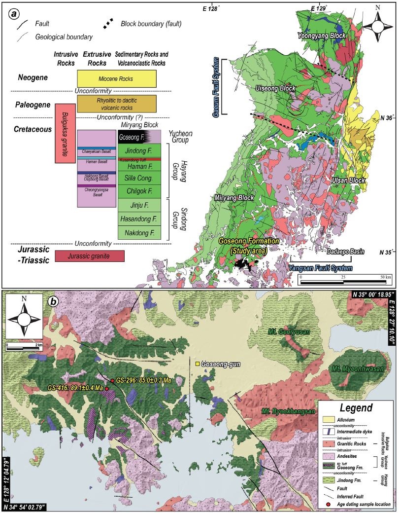
(a) Simplified geological map (modified from Hwang et al., 1996; Kim et al., 1998; Choi et al., 2002) and key beds (modified from Jeong et al., 2005; Jeon and Sohn, 2008; Hwang and Woo, 2009) of the Gyeongsang Basin. Stratigraphic correlation is reconstructed from Chang et al. (2003), Chough and Sohn (2010), and Kang and Paik (2013). (b) Detailed geological map of the study area (modified from Chang et al., 1983a; Paik et al., 2006).
이번 연구의 대상인 고성층은 층서적으로 유천층군의 최하부층에 해당하며, 행정구역상 경남 고성군 고성읍, 삼산면, 거류면과 통영시 도산면, 광도면 일원에 분포한다. 고성층은 다량의 화산물질과 자색층을 포함하고 있어, 주변에 분포하는 진동층(하양층군 최상위층)과 뚜렷하게 구분된다. 고성층은 1:5만 충무도폭(Chang et al., 1983a)에서 최초로 보고되었지만 삼천포도폭(Chi et al., 1983)에서는 고성층과 유사한 암석학적 특징을 보이는 지층이 진동층으로 표기되어 있어, 고성층의 정확한 분포와 하위의 진동층과의 명확한 경계부 특성에 대해 연구가 필요하다.
고성층의 형성과 발달사에 관한 이해는 유천층군 퇴적환경, 화산활동, 구조운동, 나아가 한반도 남동부의 후기 백악기와 그 이후의 지구조환경을 해석함에 있어 중요하다. Paik et al. (2006)은 퇴적학적 접근을 통해 고성층의 암상, 층서, 화석의 산출특성에 대한 상세 정보를 제공한 바 있으나, 고성층 퇴적 당시와 그 이후의 변형에 대한 구조지질학적 연구는 현재까지 진행된 바 없다. 따라서 이번 연구는 고성층 내부에 발달하는 다양한 지질구조요소들의 수집과 분석을 통해 고성층의 구조발달사를 규명하여 경상분지의 진화사에 진일보한 정보를 제공함에 궁극적인 목적이 있다. 이번 연구에서는 경남 고성군과 통영시 일원의 상세 지질조사를 수행하여 고성층의 분포를 명확히 하였다. 그리고 고성층의 퇴적시기를 한정하기 위하여 열쇠층이 될 수 있는 상부 고성층 내에 협재하는 데사이트질 화산회응회암과 고성층을 피복하는 안산암질 화산회응회암을 대상으로 레이저삭박 다검출기 유도결합 플라즈마 질량분석기(LA-MC-ICPMS; Laser Ablation-Multi Collector-Inductively Coupled Plasma Mass Spectrometer)를 활용한 저어콘 U-Pb 연대측정을 실시하였다. 또한 지층의 자세, 다양한 규모의 단층과 전단단열, 쇄설성/마그마성 암맥 등 여러 변형요소들에 대한 구조분석 결과를 제시하고, 이들 변형을 야기한 고응력과 상대시기를 밝혀 고성층의 구조진화사를 이해하고자 하였다.
2. 지질학적 배경
고성층은 경남 고성군 일원에 주로 노출되어 있으며 동편 고지대(거류산 일원, 면화산 일원)에도 소규모로 산출된다(그림 1). Chang et al. (1983a)은 진동층과 고성층의 접촉관계를 정합으로 보고하고 층서적 위치와 암상에 근거하여 마산도폭(Kim and Kim, 1963)의 정병산층에 대비되는 것으로 해석하였으나, Paik et al. (2006)은 진동층과 고성층이 경사부정합으로 접하며 암상과 공룡알 화석의 산출특성을 바탕으로 부산가덕도폭(Chang et al., 1983b)의 다대포층에 대비될 것으로 보고하였다. 이와 같이 고성층은 진동층과의 접촉관계와 대비에서 연구자에 따라 차이를 보인다.
호성환경에서 퇴적된 진동층은 흑색 내지 암회색의 엽층이 발달하는 실트암과 이암이 연속적으로 관찰되며 일부 이회암과 백색 사암이 협재하는 특징을 보인다. 또한 전반적으로 호상층리가 잘 발달할 뿐만 아니라 사층리, 건열, 연흔 등의 퇴적구조도 흔히 관찰된다. 반면, 하성환경에서 퇴적된 고성층은 자색 퇴적층이 출현하고 화산물질의 함량이 확연하게 증가하는 경향을 보이며, 암상에 따라 하부 고성층(녹회색/잡색 응회질 사암과 녹회색/자색 이암 발달, 응회암이 협재되어 산출), 중부 고성층(자색 사암과 이암 발달, 석회질 단괴(calcrete) 산출), 상부 고성층(자색/녹회색 사암과 이암 발달, 응회암이 협재되어 산출)으로 구분된다(Paik et al., 2006). Paik et al. (2006)은 이전 연구들에서 제시된 진동층의 절대연대 자료(Kim and Paik, 2001)와 고성층의 고자기 자료(Kang and kim, 2000)를 바탕으로 고성층이 캄파니안(Campanian; 83.6-72.1 Ma) 이후 퇴적되었으며 다대포층과 대비되는 지층으로 판단하였으나, Kim et al. (2011)이 제시한 고성층 하부 데사이트질 응회암의 SHRIMP U-Pb 저어콘 연대는 92.1±3.2 Ma 이전부터 고성층의 퇴적이 시작되었음을 지시한다.
고성층의 기원은 연구자에 따라 해석의 차이를 보인다. Paik et al. (2006)은 화산활동의 증가와 단층운동에 의해 진동층이 국부적으로 융기함에 따라 호수가 과충전되어 하성퇴적층에 해당하는 고성층이 발달한 것으로 해석한 반면, Chough and Sohn (2010)은 고성층을 경상화산호(Gyeongsang Volcanic Arc)의 활발한 화산활동 동안에 형성된 화산쇄설성 물질들이 저지대인 경상배호분지(Gyeongsang Backarc Basin)로 급격하게 쏟아져 형성된 화산쇄설성 에이프런(volcaniclastic apron)으로 해석하였다.
3. 고성층의 경계와 암상
고성층의 주 분포지는 아원형 기하(약 64 km2)를 보이며, 후기 화산암 내지 관입암으로 접하는 남쪽을 제외한 대부분의 경계에서 진동층과 접한다. 고성층과 진동층의 경계는 연구자에 따라 정합(Chang et al., 1983) 또는 경사부정합(Paik et al., 2006)으로 해석되어 왔다. 이번 지표지질조사를 통해 두 지층의 경계(서부, 북부, 동부의 거류산 일원)에서 기저역암으로 판단되는 역암층이 흔히 관찰되었다. 대표적으로 서부 경계(N34° 56' 42.53″, E128° 13' 24.36″)에서 1-5 cm 크기의 원마도가 양호하고 분급이 불량한 안산암, 자색과 암회색 이암 등 다양한 역으로 구성된 역암층이 관찰되는데, 하위의 암회색 세립질 사암 및 실트암(진동층)과 불규칙한 경계면으로 접한다(그림 2a, 2b). 북부 경계 (N34° 59' 24.72″, E128° 17' 20.72″)에서는 평균 10 cm 크기의 원마도와 분급이 불량한 암회색 이암 역으로 주로 구성된 역암이 확인되고(그림 2c), 동부 경계(거류산; N34° 58' 39.87″, E128° 23' 16.36″)에서는 다량의 화산물질을 포함하는 기질과 원마도가 양호한 화산암과 퇴적암으로 구성된 역암이 관찰된다(그림 2d). 불규칙한 기하의 침식구조는 호성환경에서 진동층이 퇴적된 이후 하성환경에서 고성층이 퇴적되기까지 시간적 간격이 존재하였음을 암시한다. 또한 고성층과 진동층의 경계를 기준으로 두 지층 사이의 자세 변화가 인지되지 않음을 고려하면 진동층과 고성층의 경계는 평행부정합으로 해석함이 가장 합리적이다. 한편, 동편의 벽방산 일원은 진동층과 고성층이 북서 방향의 단층으로 접하고 있다(그림 1).
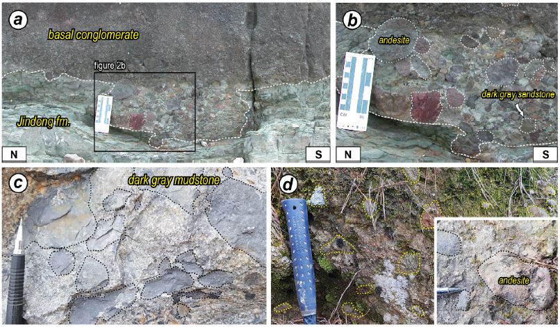
Outcrop photographs showing the relationship between the Jindong and Goseong formations. (a) Irregular scoured unconformity contact observed in the western boundary of the Goseong Formation and (b) its close-up view. (c, d) Disorganized, subangular to subrounded and poorly sorted conglomerates observed in the northern (c) and eastern (d) boundaries of the Goseong Formation.
고성층은 주로 자색 이암 내지 사암, 녹회색 사암, 응회질 퇴적암으로 구성되며, 일부 지점에서는 암회색 이암과 역질 사암 내지 역암이 협재된 양상이 확인된다(그림 3). 가장 흔히 인지되는 자색 이암 내지 사암은 응회질 사암 내지 녹회색 사암과 호층을 이룬다(그림 3a, 3b). 자색 퇴적암 내에는 퇴적기원 변형구조, 캘크리트 단괴, 공룡알과 생흔 화석 등이 존재하며, 사장석 결정편과 응회질 물질을 포함하기도 한다. 자색 퇴적암과 호층을 이루는 녹회색 사암은 자색 퇴적암에 비해 단위층의 두께가 두껍고, 기질부는 대부분 조립질에서 중립질이며 규암역을 포함하기도 한다. 또한 녹회색 사암층은 판상층리가 잘 관찰되며 사층리도 발달한다. 고성층 분포지의 북부와 동부에서 출현빈도가 높은 암회색의 세립질 사암 내지 이암 내에는 엽층이 발달하며(그림 3c), 건열, 연흔 등의 퇴적구조가 흔히 인지된다. 풍화·변질을 심하게 겪은 경우, 이 암석은 때때로 진동층과 구별하기 어려우나 진동층과는 다르게 회백색 사암과의 호층이 거의 관찰되지 않는다. 연구지역에서 드물게 산출되는 역질 사암 내지 기질지지성 역암은 안산암, 퇴적암, 응회암 등 다양한 기원의 역들을 포함한다(그림 3d). 내부의 역들은 원마도는 양호하나 분급은 불량하며, 층리와 평행하게 배열된다. 한편, 하부(그림 3e)와 상부(그림 3f) 고성층에는 측방 연장성이 양호한 응회암이 2매 이상 협재한다. 특히 하부 고성층에서 확인되는 데사이트질 응회암은 약 35 cm의 화산회응회암과 직상부의 약 20 m 이상 두께를 가지는 화산력응회암으로 구분된다(그림 3e). 화산회응회암은 세립질 기질에 다량의 장석 결정과 소량의 부석을 포함하며 층상 구조가 잘 인지되는 반면, 괴상의 화산력응회암에서는 조립질 기질에 평균 5 cm 크기의 퇴적암편, 안산암편, 응회암편 등을 비롯한 부석과 장석 결정이 확인되며, 상향조립화하는 경향을 보인다. 이 화산력응회암은 부석 내지 암편들이 늘어난 용결구조가 뚜렷하게 인지되며 탄화목을 포함한다. 한편, 고성층을 피복하고 있는 유천층군 안산암류는 화산회응회암, 화산력응회암, 화산각력암 그리고 용암 등 다양한 형태로 산출된다. 특히 화산회응회암은 고지대에서 괴상으로 분포하며(그림 3g), 안산암질 기질부 내에 약 1 mm 크기의 장석, 휘석 결정편과 소량의 부석을 함유한다.
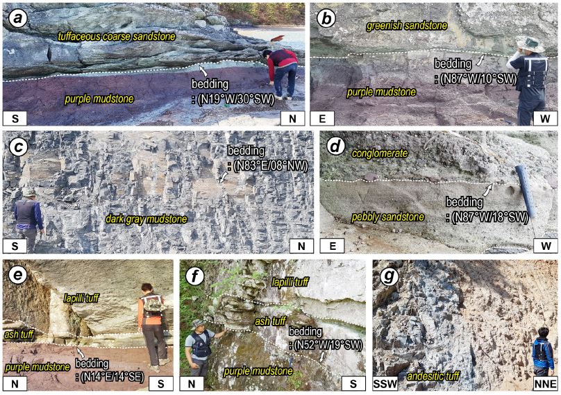
Outcrop photographs showing the major lithologies of the Goseong Formation. (a) Massive purple mudstone and overlying tuffaceous sandstone. (b) Purple mudstone and greenish sandstone, which are dominant lithologies within the Goseong Formation. (c) Well-stratified dark gray mudstone, mainly observed in the northern and eastern parts of the formation. (d) Crudely stratified conglomerate and pebbly sandstone. (e-f) Dacitic tuff layers observed in the lower (e) and upper (f) parts of the Goseong Formation, respectively. Each tuff layer consists of lower ash tuff unit and upper lapilli tuff unit. (g) Yucheon Group andesitic ash tuff overlying the Goseong Formation.
4. 고성층의 퇴적시기
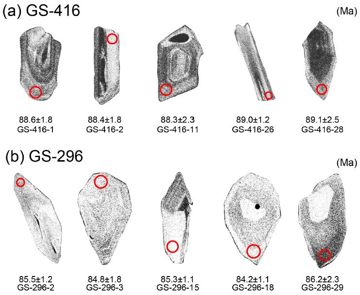
고성층의 퇴적시기를 한정하기 위해 고성군 삼산면 병산리 갈모봉 일원에서 상부 고성층에 협재하는 데사이트질 화산회응회암(GS-416; N34° 57' 51.28″ E128° 15' 59.11″)과 고성층을 피복하고 있는 유천층군 안산암질 화산회응회암(GS-296; N34° 58' 01.88″ E128° 16' 09.73″)의 시료를 채취하여 절대연대를 측정하였다(그림 1, 4, 5; 표 1, 2). 절대연대 측정은 한국기초과학지원연구원 오창센터에 설치된 레이저삭박 다검출기 유도결합플라즈마 질량분석기(LA-MC-ICPMS)를 사용하였다. 레이저 장치와 결합한 유도결합플라즈마 질량분석기(ICPMS)를 활용한 U-Pb 저어콘 연대측정은 기존의 열이온화질량분석기(TIMS), 이차이온질량분석기(SIMS)에 비해 짧은 시간 동안 많은 시료의 분석이 가능하여 쇄설성 저어콘 입자의 연대를 획득하는데 널리 활용된다. 분석 시에는 시료 당 각각 30개의 저어콘 입자를 측정하여 통계학적인 신뢰도를 높이고자 하였다. 분석 결과를 살펴보면 고성층 상부 데사이트질 화산회응회암은 89.1±0.4 Ma, 안산암질 화산회응회암은 85.0±0.3 Ma의 연대가 도출되었으며(그림 4; 표 1, 2), 이는 고성층의 퇴적이 약 89-85 Ma 사이에 종결되었음을 지시한다. 따라서 고성층 하부의 데사이트질 응회암에서 추출한 쇄설성 저어콘의 연대측정 결과(SHRIMP U-Pb 연대: 92.1±3.2 Ma; Kim et al., 2011)와 종합할 때, 고성층의 퇴적은 약 92 Ma 이전부터 시작하여 약 89-85 Ma 사이에 종결된 것으로 판단된다.
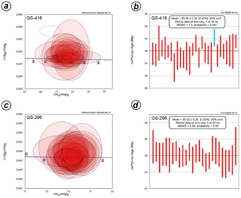
LA-ICP-MS U-Pb zircon dating results. (a) Tera-Wasserburg and (b) 206Pb/238U weighted mean age plots of the dacitic ash tuff in the upper Goseong Formation. (c) Tera-Wasserburg and (d) 206Pb/238U weighted mean age plots of the andesitic ash tuff overlying the Goseong Formation.
5. 지질구조
5.1 지층 자세
Paik et al. (2006)은 고성층의 지층 자세가 전반적으로 분포지의 중심부로 경사져 고성층이 접시모양의 향사구조를 보이나, 습곡, 단층, 화산암류의 분출과 암맥의 관입에 의해 지층이 국지적으로 교란되어 있음을 보고하였다.
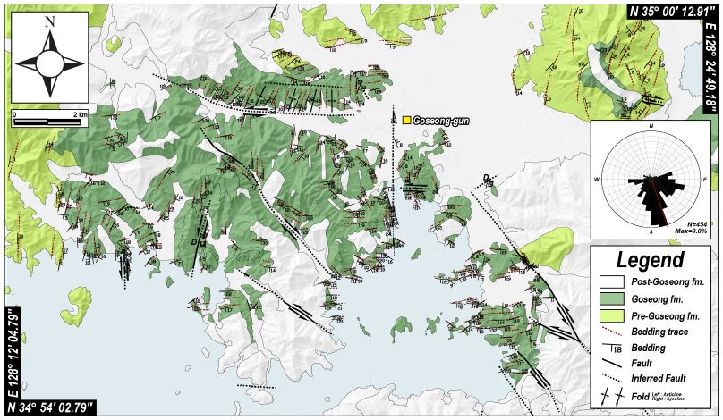
이번 연구에서는 고성층과 주변 진동층의 지층 자세를 보다 정밀하게 파악하기 위해 총 454개의 지층 자세를 측정하여 구조도(structural map)에 표현하였다(그림 6). 연구지역의 지층들은 전반적으로 남쪽으로 경사지는 특징을 보이는데, 이러한 경향은 남쪽 해안가에서 특히 우세하다. 연구지역의 서편은 지층들이 대부분 동쪽 내지 남동쪽으로 경사져 주변 하양층군의 전반적인 지층 자세와 유사하다. 한편, 단층, 관입암체, 화산암체 인접부에서는 지층이 심하게 교란되는 양상이 확인된다. 단층 인접부의 지층은 단층의 자세와 대체로 유사하게 회전되는 경향을 보이지만, 고성층 분포지 북부의 나란하게 배열되는 두 조의 동-서 방향 단층 사이에는 남-북 내지 북북동 방향의 축을 갖는 습곡구조가 인지됨이 특징이다(그림 6).
5.2 구조요소들의 기하와 운동학적 특성
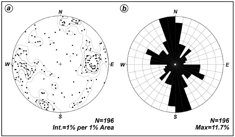
고성층 내에 존재하는 구조요소들의 기하와 운동학적 특성을 밝히고 이들의 선후관계를 조사하였다. 야외에서 관찰된 총 196개 단층들의 자세는 남-북 내지 북북서 방향이 가장 우세하며 북서 내지 서북서 방향의 것도 다수 관찰된다(그림 7). 이들 단층은 변형 양상에 따라 퇴적동시성과 후기 단층으로 구분된다. 퇴적동시성 단층은 대부분 단층암이 발달하지 않고 절단면으로만 인지된다. 또한 동일 층준에 해당하는 퇴적단위가 단층의 하반보다 상반에서 더 두꺼운 점완/서가형 또는 공액상의 정단층 기하를 보인다. 반면 퇴적 이후에 형성된 단층들은 주향이동 내지 사교이동감각이 우세하게 인지되며, 변위량에 관계없이 3 cm 이내의 좁은 띠로 전단이 집중되는 경향을 보인다. 단층손상대 내에서 확인되는 다수의 광맥과 변질대는 연구지역 일원이 단층활동과 수반된 열수작용이 활발했음을 지시한다. 이번 연구에서는 성장단층(growth fault)과 쇄설성 암맥(clastic dyke)의 형성시기를 첫 번째 변형단계(퇴적동시성)로 판단하였고, 퇴적 후에 형성된 구조들의 횡절관계를 이용해 퇴적 이후 4번의 변형단계(D2-D5)가 있었음을 제안한다. 퇴적동시성 구조는 경사보정을 실시하고 단층이동(slip) 자료가 없는 경우에는 기하 분석을 통해 최소수평응력(σHmin)을 결정하였으며(그림 9a), 단층이동 자료가 확보된 퇴적동시성 구조와 퇴적 이후의 지질구조는 Delvaux and Sperner (2003)의 Wintensor S/W (v.5.8.5)를 활용하여 고응력장을 결정하였다(그림 8). 복원된 고응력장 도표에서 표현되는 발산(divergence)형과 수렴(convergence)형의 화살표는 각각 최소수평응력(σHmin)과 최대수평응력(σHmax) 방향을 나타내며, R‘ ratio (응력비)값은 응력환경(stress regime)의 형태를 지시한다[0≤R'≤1 (σ1이 수직; 인장환경), 1≤R’≤2 (σ2가 수직; 주향이동환경), 2≤R’≤3 (σ3이 수직; 압축환경); R=(σ2-σ3)/(σ1-σ3); Delvaux et al. (1997)]. 이번 연구에서는 응력과 변형에 대한 용어 사용에서의 혼란을 피하기 위해 “인장력(extensional stress)”과 “압축력(compressional stress)”은 응력에 대한 용어로, “신장(extension)”과 “수축(contraction)”은 변형에 대한 용어로 국한하여 사용한다(Twiss and Moores, 2007). 변형단계별 응력장과 선후관계를 결정할 수 있는 대표 노두들은 다음과 같다.
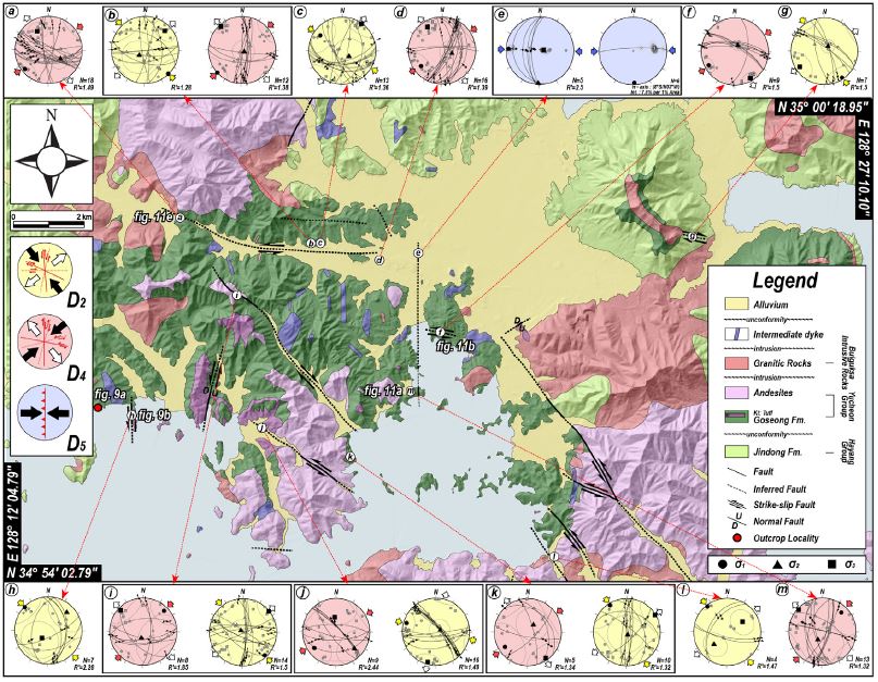
Slip data obtained from the post-depositional faults and fold axes estimated from best-fitting π-circle of various attitudes of fold limbs (lower-hemisphere, equal-area projection). Convergent and divergent arrow heads represent contraction (σHmax) and horizontal stretch (σHmin) direction, respectively. When determined, the principal stress axes σ1 (circles), σ2 (triangles), σ3 (squares) are also projected. Based on the relative chronologies at the outcrops, reconstructed paleostress regimes are grouped into (1) NW-SE compression or NE-SW tension (D2), (2) NE-SW compression or NW-SE tension (D4), and (3) E-W compression (D5), in ascending order. R΄=R (σ1 is vertical), or 2-R (σ2 is vertical), or 2+R (σ3 is vertical) [Delvaux et al., 1997; R=(σ2-σ3)/(σ1-σ3)].
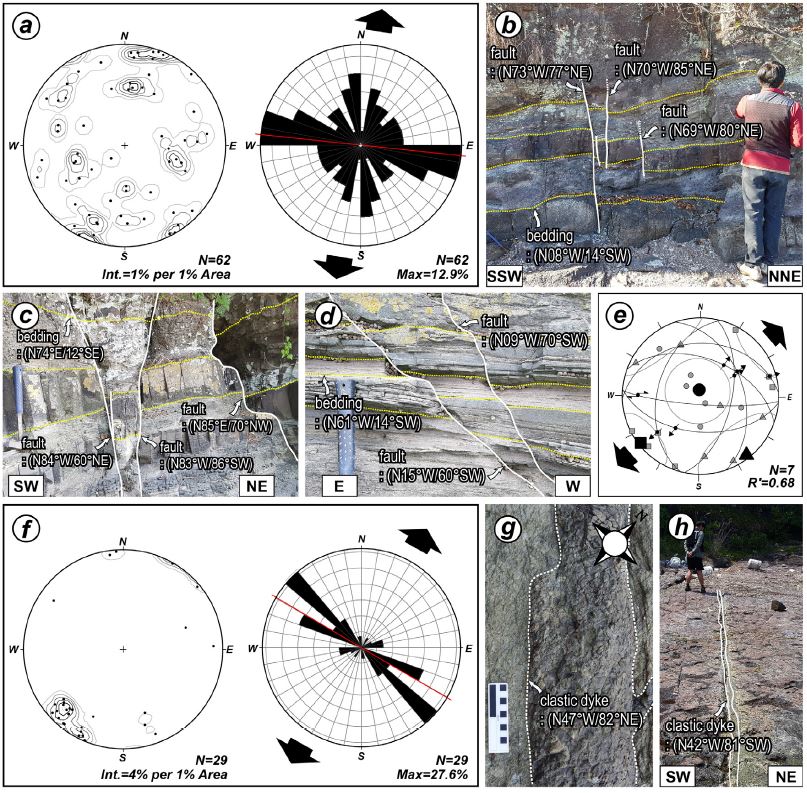
Outcrop photographs and diagrams showing the major features of the syndepositional structures (D1). (a) Contour and rose diagrams showing the attitudes of all growth faults within the Goseong Formation. Note that WNW-striking growth faults are dominant. (b, c) WNW-striking growth faults. (d) N-S-striking growth fault. (e) Reconstructed paleo-stress regime indicating NE-SW tension (D1) (f) Contour and rose diagrams showing the attitudes of all clastic dyke within the Goseong Formation. (g, h) NW-striking clastic dykes containing various lithic fragments, which are poorly sorted and angular.
고성층 내에서 확인된 성장단층들은 서북서 방향이 가장 우세하며, 남-북 방향 또한 간혹 관찰된다(그림 9a). 이들 단층은 대부분 점완/서가형 또는 공액상의 정단층 기하와 함께 10 cm 내외의 수직변위를 보이며(그림 9b-d), 일부 서북서 방향 단층면에서는 정이동성 감각의 단층조선이, 남-북 방향 단층면에서는 좌수향 횡인장성 사교이동감각의 단층조선이 우세한 경향을 보인다. 성장단층 내에서 관찰된 단층이동 자료를 이용하여 얻어진 고응력은 북동-남서 인장을 지시한다(그림 9e).
쇄설성 암맥은 지진활동으로 미고결 퇴적물이 액상화되어 최소주응력(σ3)에 거의 수직한 방향의 인장단열을 따라 주입된 것으로 해석되며, 연구지역에서 확인된 29개의 쇄설성 암맥들은 성장단층의 방향과 유사하게 서북서 내지 북서 방향이 우세하다(그림 9f). 쇄설성 암맥의 두께는 보통 1-5 cm 이지만 드물게 10 cm 이상의 폭을 가지는 것도 있으며 기질의 입자 크기와 역의 존재 유무에 따라 (1) 세립질 내지 중립질 기질부에 아원형-아각력의 역을 포함한 것(그림 9g, 9h)과 (2) 세립질 입자로만 구성된 것으로 구분된다. 전자의 경우에는 분급이 불량하며 퇴적암, 응회질 퇴적암 등 다양한 역들을 포함하는 것들이 대부분이지만 단종의 역으로 구성되는 것도 일부 확인된다. 또한 일부 쇄설성 암맥의 기질부는 화산물질을 포함하기도 한다. 전술한 퇴적동시성 구조들의 기하와 운동학적 특징에 근거할 때, 고성층 퇴적 당시에는 북북동-남남서 내지 북동-남서 방향의 인장력(R‘=0.68)이 우세하게 작동한 것으로 해석된다.
5.2.2.1 북서-남동 수축/북동-남서 신장(D2)
고성군 하일면 용태리 해안 노두(N34° 56' 28.99″, E128° 13' 40.36″; 그림 10a)에서 두 매의 단층이 북서 방향의 쇄설성 암맥을 절단하고 있다. 남-북 방향(N07°E/88°SE)과 서북서 방향(N74°W/89°NE)의 두 단층은 각각 좌수향과 우수향 감각으로 쇄설성 암맥을 절단하고 있어 공액상 단층운동을 한 것으로 판단된다. 단층면을 따라 단층조선과 단층암은 인지되지 않으나, 인접부에서 남-북 또는 서북서 방향의 소규모 전단단열들이 밀집되어 발달한다.
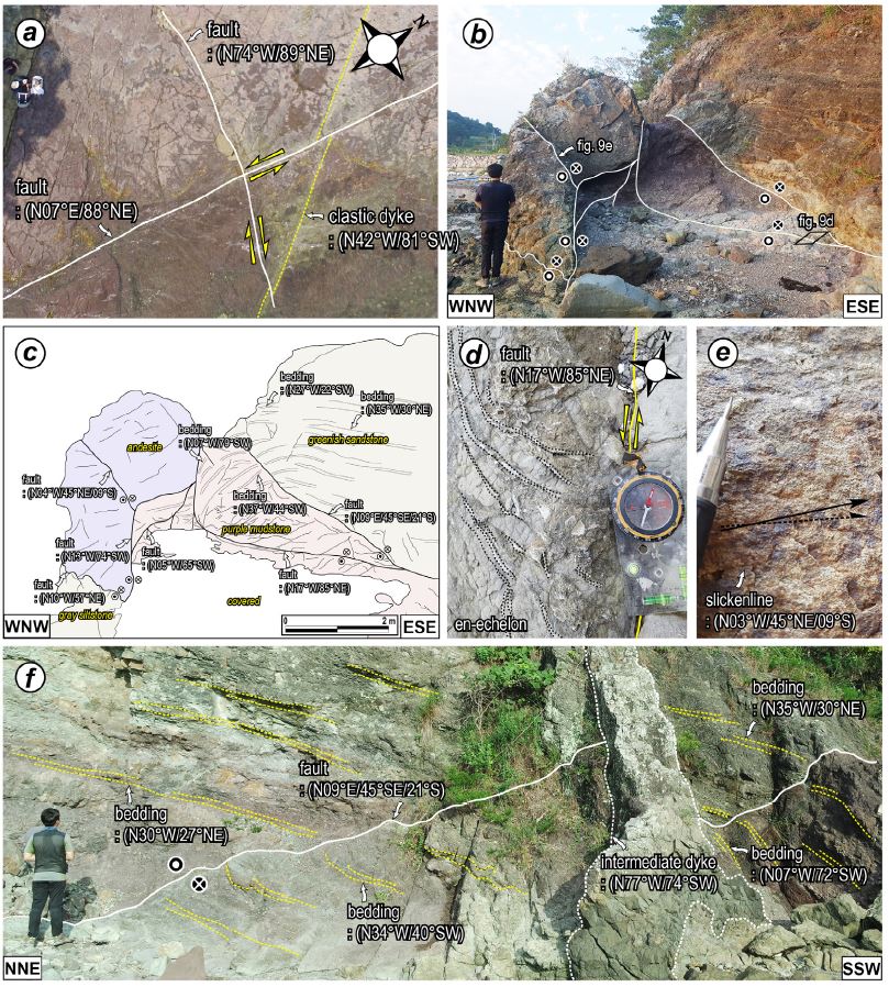
Fig. 10. Outcrop photographs and sketch of the post-depositional faults formed under NW-SE compressional or NE-SW tensional stress field (D2). (a) NW-striking clastic dyke offset by N-S-striking dextral fault and WNW-striking sinistral fault. (b) N-S-striking sinistral strike-slip faults and its (c) sketch. The fault shows a network of multiple anastomosing strands. (d) NW-striking en-echelon veins indicating a sinistral sense of the N-S-striking fault. (e) Slickenline indicating sinistral strike-slip sense observed on the N-S-striking fault surface. (f) The N-S-striking fault transected by a WNW-striking intermediate dyke.
고성군 삼산면 장치리 해안 노두(N34° 56' 28.09″, E128° 14' 13.69″; 그림 10f)에는 고성층을 절단하는 남-북 방향의 단층이 서북서 방향의 중성질 암맥에 의해 절단됨을 보여준다. 한편, 이 노두 남쪽 약 3 m 연장부에는 수 매의 남-북 내지 북북서 단층들이 합쳐지거나 분기되는 기하를 보여주는데(그림 10b, 10c), 단층면을 따라 단층암은 발달하지 않으며 방해석 맥이 곳곳에 충전된 양상이다. 노두 전반에 발달한 방해석 맥들은 단층의 자세와 유사한 남-북 방향이 우세하지만 망상의 기하를 보이기도 한다. 자색 이암층과 녹회색 사암층을 절단하는 단층(N09°E/45°SE)은 서편에 발달하는 단층(N17°W/85°NE)과 합쳐지면서 고각의 경사로 변화하며 상반과 하반에서는 끌림습곡이 확인된다. N17°W/85°NE 자세의 단층은 자색 이암층과 이를 피복한 안산암을 절단하며, 단층 인접부에서는 안행상(en-echelon) 배열의 북서 방향 광맥들이 관찰되어 단층의 좌수향 운동을 지시한다(그림 10d). 이와 함께 단층면에서 인지되는 단층조선과 결정섬유(crystal fiber)의 성장방향 역시 좌수향 주향이동감각을 지시한다(그림 10e). 이상의 특징들은 남-북 내지 북북서 단층들의 좌수향 운동이 중성질 암맥의 관입 이전에 작동한 북서-남동 방향의 최대수평응력(R‘=1.28~2.28) 하에서 발생하였음을 지시한다.
5.2.2.2 중성질 암맥군의 관입(D3)
고성층을 관입하는 중성질 암맥들은 남-북 방향이 가장 우세하며 북서 내지 서북서 방향의 것들도 흔하다(그림 11). 야외에서 이 둘 간의 명확한 횡절관계는 관찰하지 못하였으나 한반도 남동부 일원의 암맥들에 대한 기존 Ar-Ar 연대측정 결과들은 서북서 방향의 암맥군(64-52 Ma)이 관입한 이후에 남-북 방향의 암맥군(51-44 Ma)이 관입한 것으로 해석되고 있다(Kim et al., 2005; Son et al., 2007). 또한 Jwa and Park (1996)이 수행한 연구지역 동부(벽방산 일원)에서의 중성질 암맥군의 K-Ar 연대 역시 57.8±1.8 Ma로 이들 암맥이 고신생기초에 관입하였음을 지시한다. 이들 중성질 암맥 중 일부는 단층을 절단하거나 단층에 의해 절단되어 있으며, 암맥면을 따라 전단이 발생한 경우도 흔히 관찰되어 연구지역에서 변형단계를 구분하는데 중요한 기준으로 활용될 수 있다. 실제 두 방향성의 암맥군이 주입된 응력환경은 시기가 서로 다르지만, 이번 연구에서는 명확한 선후관계를 인지하지 못하였으므로 중성질 암맥군의 관입 사건 자체를 하나의 사건으로 설정하였다.
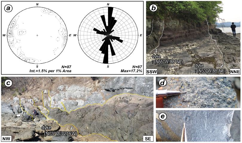
Outcrop photographs and diagrams showing the major features of the intermediate dyke swarm (D3). (a) Contour and rose diagrams showing the attitudes of all intermediate dyke in the study area. (b, c) WNW- and N-S-striking intermediate dyke intruding the Goseong Formation. (d, e) Close-up views showing porphyritic texture (d) and fine-grained texture (e).
5.2.2.3 북동-남서 수축/북서-남동 신장(D4)
고성군 삼산면 판곡리의 절개사면(N34° 56' 44.43″, E128° 19' 01.31″; 그림 12a)에서는 1 m 두께의 남-북 방향 중성질 암맥을 기준으로 고성층 사암과 실트암이 약 4 m 수직 변위된 양상이 확인된다. 암맥의 서편 경계면에서는 우수향 횡인장성 사교이동감각의 단층조선(선주각: 50°N)이 뚜렷하게 인지되고, 암맥 인근의 남-북 방향 전단단열을 따라서도 우수향 횡인장성 주향이동감각 내지 우수향 주향이동감각이 확인된다. 반면 서북서 내지 동-서 방향의 전단단열에서는 체계적으로 좌수향 주향이동감각이 인지된다.
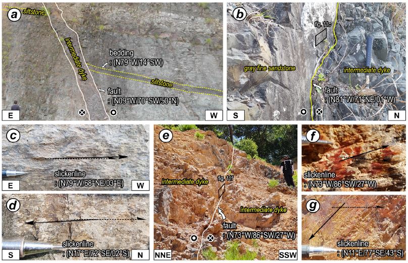
Outcrop photographs showing the major features of the post-depositional faults formed under NE-SW compressional or NW-SE tensional stress field (D4). (a) N-S- and (b) WNW-striking intermediate dyke, which underwent dextral and sinistral slips on their contacts, respectively. (c) Slickenline indicating the sinistral strike-slip sense. (d) Slickenline indicating the dextral strike-slip sense. (e) WNW-striking sinistral strike-slip fault cutting the intermediate dyke. (f) Slickenline indicating the sinistral, reverse oblique-slip sense on the WNW-striking fault surface. (g) Slickenline indicating the dextral, normal oblique-slip sense on the N-S striking shear fracture.
고성군 고성읍 신월리의 절개사면(N34° 57' 33.66″, E128° 19' 32.24″; 그림 12b)에서도 서북서 방향의 중성질 암맥면을 따라 좌수향 주향이동감각의 전단흔적이 확인된다. 단층 인접부의 세립질 사암 내에는 동북동 방향의 안행상 방해석 광맥들이 발달하고 있어, 서북서 방향의 좌수향 전단에 수반된 인장 틈 내로 열수가 유입된 것으로 해석된다. 이곳에 발달한 서북서 방향 전단단열들은 좌수향 주향이동이 우세한 반면(그림 12c), 남-북 방향의 전단단열들은 우수향 주향이동감각을 지시하는 단층조선과 결정섬유가 발달한다(그림 12d).
고성군 상리면 부포리에서 발견된 서북서 방향의 단층(N34° 59' 07.63″, E128° 14' 59.39″; 그림 12e)은 대규모 중성질 암맥을 절단한다. 단층암은 발달하지 않으나 단층면에서 좌수향 횡압축성 주향이동감각의 조선이 확인된다(그림 12f). 이 단층 주변에서 흔히 관찰되는 동-서 내지 서북서 방향의 전단단열들은 주 단층과 유사하게 좌수향 주향이동감각을 보이나, 일부 남-북 방향의 전단단열들은 우수향 주향이동감각 내지 우수향 횡인장성 사교이동감각의 조선을 보여준다(그림 12g). 이상의 특징들은 연구지역이 중성질 암맥의 관입 이후 응력장이 바뀌어 북동-남서 방향의 최대수평응력(R‘=1.32~2.44) 하에 놓여 있었음을 지시한다.
최근 필자들은 고성군 고성읍 서외리 도로공사 절개사면(N34° 58' 38.61″, E128° 19' 07.08″)에서 남-북 방향의 단층(N01°E/48°NW)이 고성층과 이를 부정합으로 피복한 제4기층(OSL 연대: 61-60 ka)을 상반동향(top-to-the-east)의 충상 기하로 절단함을 보고한 바 있다(Lee et al., 2017). 제4기층을 절단한 단층의 직하위에는 전단력에 의해 회전된 제4기 역들이 단층면과 (아)평행하게 배열되며, 주변 고각의 남-북 방향 전단단열들에서도 순수 역이동성 감각의 조선이 발달함을 보고하였다. 또한 단층 상반의 고성층 실트층 내에서 역이동성 층간 전단에 의한 엽리와 습곡을 인지하였다. 이러한 보고는 연구지역에서 기존의 남-북 방향 단층이 제4기의 동-서 방향의 최대수평응력(R‘=2.5) 하에서 일부 재활하였음을 지시한다(Lee et al., 2017).
6. 고응력장 변화와 지각변형 특성
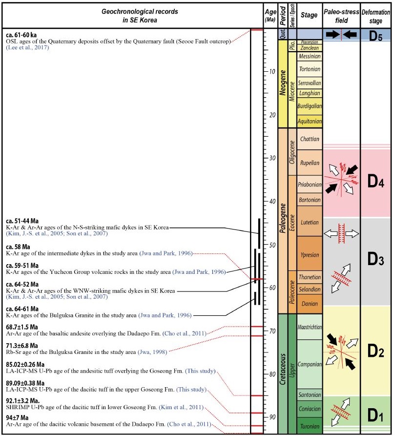
고성층 내에 존재하는 구조요소들(단층, 전단단열, 쇄설성/마그마성 암맥)의 기하, 운동학적 특성과 이들의 횡절관계는 연구지역의 변형단계가 순차적으로 (1) 북북동-남남서 내지 북동-남서 신장 시기(D1), (2) 북서-남동 수축/북동-남서 신장 시기(D2), (3) 중성질 암맥군 관입 시기(D3), (4) 북동-남서 수축/북서-남동 신장 시기(D4) 그리고 (5) 동-서 수축 시기(D5) 순임을을 지시한다(그림 13). 이번 연구와 기존 연구 결과들을 종합하여 한반도 남동부에서 발생한 백악기 이후 각 변형단계의 시기와 특성을 토의하면 다음과 같다.
6.1 백악기말(D1-D2)
연구지역 초기 응력에 해당하는 북북동-남남서 내지 북동-남서 최소수평응력은 고성층의 퇴적과 함께 서북서 내지 북서 방향의 퇴적동시성 신장구조를 형성시켰다(그림 9, 13). 또한 고성층 하부에 위치한 데사이트질 응회암의 SHRIMP U-Pb 연대(92.1±3.2 Ma) (Kim et al., 2011)와 LA-ICP-MS U-Pb 연대(고성층 상부에 발달하는 데사이트질 화산회응회암: 89.1±0.4 Ma, 고성층을 피복하는 안산암질 화산회응회암: 85.0±0.3 Ma)는 고성층의 퇴적이 D1 인장응력 하에서 약 92 Ma 이전부터 시작되어 약 85 Ma 이전에 종결되었음을 지시한다. 두 번째 변형단계에서는 북서-남동 최대수평응력/북동-남서 최소수평응력 하에서 남-북 내지 북북동 방향 단층의 좌수향 운동과 서북서 방향 단층의 우수향 운동으로 대표되는 변형이 발생하였으며, 이들 구조는 중성질 암맥군에 의해 절단된다(그림 10, 13).
북북동 방향의 양산단층과 동래단층 사이에 위치한 다대포분지의 충전물인 다대포층은 기반암인 데사이트질 응회암과 다대포층을 피복하는 현무암질 안산암의 Ar-Ar 연대에 기초하여 94-69 Ma 사이에 퇴적된 것으로 해석된다(Cho et al., 2011). 또한 분지 내 지층자세, 단층, 쇄설성/마그마성 암맥 등을 이용한 구조지질학적 연구는 다대포분지의 확장이 양산단층과 동래단층의 좌수향 주향이동운동에 수반된 북북동-남남서 내지 북동-남서 인장력의 결과로 해석하였다(Cho et al., 2016). 따라서 고성층과 다대포층은 유사한 응력장 하에서 거의 동시에 퇴적이 시작되었으나 다대포층의 퇴적이 보다 오랫동안 지속된 것으로 해석된다.
Cho et al. (2007)은 양산단층과 동래단층 사이에 분포하는 경주-울산지역 화강암류(70-60 Ma)의 북동 방향 자기엽리구조가 양산단층계의 좌수향 주향이동운동에 수반된 북서-남동 방향 압축력에 의한 것으로 해석하였다. 최근 양산단층계를 따라 실시된 구조지질학적 연구결과들도 양산단층계의 우수향 주향이동 이전에 좌수향 주향단층운동이 있었음을 보고하고 그 시기를 백악기말로 해석하고 있다(Ha et al., 2016; Cheon et al., 2017a).
이러한 연구결과들은 북북동-남남서 내지 북동-남서 신장(D1 변형)과 뒤이은 북서-남동 수축/북동-남서 신장(D2 변형)이 백악기말에 동아시아 일원 지구조환경의 특별한 변화가 발생하였음을 지시하기 보다는 한반도 남동부에 작동된 응력장의 최대주응력(σ1)과 중간주응력(σ2) 축의 방향만 서로 바뀌었을 가능성을 지시한다.
6.2 고신생기초(D3)
일반적으로 수동형 관입(passive injection)은 최소주응력(σ3)에 수직한 인장단열을 따라 마그마가 채워져서 일정한 방향성을 가지는 암맥군(dyke swarm)을 형성한다(Price and Cosgrove, 1990). 따라서 같은 조성의 암맥들이 체계적인 방향성을 보이며 밀집되어 산출될 경우, 지각변형사나 광역적인 고응력장을 규명하는데 중요 자료가 될 수 있다(Speight and Mitchell, 1979; Delaney et al., 1986; Kim et al., 2002a, 2005; Son et al., 2007).
연구지역 암맥은 남-북과 서북서 방향의 것들이 가장 우세하나(그림 11), 야외에서 두 방향 암맥들 간의 횡절관계는 확인하지 못하였다. 하지만 일부 서북서 방향의 암맥이 남-북 방향의 좌수향 주향이동단층(D2 변형)을 절단함이 관찰된다(그림 10f). 거제도와 경주-감포 일원의 암맥들에 관한 기존 연구들(Kim et al., 2002a, 2002b, 2005; Son et al., 2007)은 이번 연구와 유사하게 이들 지역의 암맥들이 유사한 암석학적 특징을 가지는 남-북과 서북서(북서) 방향의 두 종류 암맥군으로 구분됨을 보고하였다. 따라서 연구지역의 남-북과 서북서 방향 암맥들의 관입은 광역적인 지구조환경과 밀접히 연관될 가능성이 높다.
Son et al. (2007)은 암맥간의 횡절관계와 절대연령(K-Ar과 Ar-Ar)을 이용하여 서북서 방향 암맥군의 관입 시기를 64-52 Ma로, 남-북 방향 암맥군의 관입 시기를 51-44 Ma로 보고하고, 이를 바탕으로 약 51 Ma 전후로 한반도 남동부의 고응력장이 북북동-남남서 최소수평응력에서 동-서 내지 서북서-동남동 최소수평응력으로 변화하였음을 제안하였다. 따라서 연구지역 서북서 방향의 암맥들은 앞선 북서-남동 최대수평응력/북동-남서 최소수평응력의 지속 또는 유사한 고응력장 하에서 마그마활동이 활발해진 결과로 해석되며, 이후 광역적인 응력장이 동-서 최소수평응력으로 변화하여 남-북 방향의 암맥들이 관입한 것으로 해석된다. 한편, Jwa and Park (1996)에 의해 수행된 연구지역 중성질 암맥의 K-Ar 연대는 약 58 Ma로써 전술한 연구 결과와 부합된다.
6.3 44 Ma 이후(D4)
중성질 암맥의 관입 이후 연구지역은 북동-남서 최대수평응력/북서-남동 최소수평응력이 작동하여 남-북 내지 북북동 방향 단층의 우수향 주향이동과 서북서 방향 단층의 좌수향 주향이동을 발생시킨 것으로 해석된다. 이러한 변형은 중성질 암맥들의 관입면에서 인지되거나 중성질 암맥들을 절단하는 양상으로 나타난다(그림 12, 13).
양산단층계는 백악기말 이후 지구조환경의 변화에 따라 다중변형을 받은 것으로 알려져 있다(Choi et al., 2009; Ha et al., 2016; Cheon et al., 2017a). 단층대를 따라 인지되는 지층의 수평변위와 다양한 변형구조들의 특성들은 양산단층계를 따라 발생한 단층운동 중 우수향 주향이동이 가장 큰 변형을 남겼음을 알려주며, 절단된 암석의 절대연대 등을 종합할 때 그 운동시기는 고신생기말로 해석된다(Choi et al., 2009; Ha et al., 2016; Cheon et al., 2017a). 또한 Cheon et al. (2017b)은 경상분지 의성지괴에 서북서 방향으로 발달하는 가음단층계의 광역적인 좌수향 횡압축성 주향이동운동 역시 고신생기말 북동-남서 압축력에 의해 발생한 것으로 해석하였다. 이상의 기존 연구결과들에 근거할 때, 이번 연구지역에서 확인되는 남-북 내지 북북동 방향의 우수향과 서북서 방향의 좌수향 단층은 고신생기초 중성질 암맥군의 관입 이후, 고신생기말 북동-남서 수축/북서-남동 신장의 결과인 것으로 해석되나 정확한 시기를 한정하기는 어렵다.
6.4 제4기(D5)
연구지역 내의 최후기 변형은 제4기 동안 동-서 압축력 하에서 기존 남-북 방향 단층들의 일부가 역단층으로 재활된 것으로 특징지어진다(Lee et al., 2017). 한반도 내에서 확인된 제4기 단층들은 대부분 양산단층계, 울산단층, 연일구조선, 오천단층계 등 남동부의 주요 지구조선을 따라 집중적으로 확인되며, 동북동-서남서 내지 동-서 방향의 압축력에 의해 재활된 것으로 알려져 있다(Okada et al., 1994; Kyung, 1997, 2003; Ryoo et al., 1996, 2001, 2002; Chwae et al., 1998; Kyung et al., 1999a, 1999b; Lee, B.J. et al., 1999; Chang, 2001; Kyung and Chang, 2001; Lee, 2003; Choi, W.-H., 2003; Kim, Y.-S. et al., 2004, 2011; Choi, P., 2005; Kim and Jin, 2006; Kee et al., 2007; Ryoo, 2009; Jin et al., 2013; Lee, J. et al., 2015; Kim, M.C. et al., 2016). 연구지역 내에서는 대규모 약대가 발달하지 않음에도 불구하고 현생 동북동-서남서 내지 동-서 방향의 압축력에 수반되어 일부 단층이 선택적으로 재활되고 있는 것으로 판단된다.
7. 결 론
이번 연구는 경남 고성 일원의 상세 야외조사를 통해 유천층군 고성층의 경계특성을 밝히고, 구조요소들의 기하와 운동학적 특성 그리고 이들의 횡절관계를 통해 고성층의 구조발달사를 규명하고자 하였다. 주요 결론은 다음과 같다.
- 1) 약 64 km2 면적의 아원형 분포를 가지는 고성층은 하위의 하양층군 진동층과 평행부정합으로 접하며 유천층군 안산암류 또는 불국사화강암류에 의해 피복 또는 관입되어 있다. 고성층의 암상은 자색의 응회질 퇴적암, 녹회색 사암, 암회색 이암, 백색 화산회응회암, 화산력응회암과 소량의 역암으로 구성된다. 연대측정 결과를 종합하면 고성층의 퇴적은 약 92 Ma 이전에 시작되어 89-85 Ma 사이에 종결되었다. 이러한 결과는 고성층은 다대포층과 유사한 시기에 퇴적이 시작되었으나 다대포층에 비해 빨리 퇴적이 종결되었음을 지시한다.
- 2) 연구지역 내에 존재하는 단층들은 남-북 방향과 북서 내지 서북서 방향이 우세하다. 점완/서가형 또는 공액상의 정단층 기하를 보이는 성장단층은 서북서 방향이 가장 우세하다. 대부분의 퇴적 이후에 형성된 단층들은 주향이동 내지 사교이동운동을 겪었으며, 단층손상대 내에는 단층과 유사한 방향성의 방해석 맥과 열수변질대가 흔히 관찰되어 단층활동에 수반된 열수작용이 활발하였음을 지시한다.
- 3) 연구지역의 변형 단계는 백악기말의 북북동-남남서 내지 북동-남서 신장 시기(D1)와 북서-남동 수축/북동-남서 신장 시기(D2), 고신생기초의 중성질 암맥들의 관입 시기(D3), 고신생기말의 북동-남서 수축/북서-남동 신장 시기(D4), 마지막으로 제4기 동-서 수축 시기(D5)로 구분된다. D1과 D2는 백악기말 동아시아 일원의 지구조환경의 거시적인 변화를 지시하기 보다는 한반도 동남부응력장의 최대주응력(σ1)과 중간주응력(σ2) 축의 방향이 국지적으로 서로 바뀐 결과로 해석된다.
- 4) 고신생기초의 중성질 암맥들은 서북서 방향과 남-북 방향의 암맥군으로 구분된다. 서북서 암맥군은 이전에 작동되었던 북서-남동 최대수평응력/북동-남서 최소수평응력의 지속 또는 유사한 고응력장 하에서 마그마활동이 활발해진 결과이며, 이후 광역적인 응력장이 동-서 최소수평응력으로 변화되어 남-북 방향의 암맥들이 관입한 것으로 해석된다.
- 5) D4는 고신생기말 북북동 방향의 양산단층계에서 발생한 대규모 우수향 주향이동운동과 시기를 같이하는 것으로 판단되며, 연구지역은 현생 동-서 방향의 광역적 압축력 하에서 고성층 내 일부 단층이 선택적으로 재활되고 있다.
Acknowledgments
본 연구는 행정안전부 ‘2017년도 재난관리지원기술개발사업(2017-MOIS31-006)’과 ‘지진방재분야 전문인력 양성’ 사업의 연구비 지원에 의해 수행되었다. 심사과정에서 세심하고 건설적인 조언과 비평을 해주신 한래희 교수님과 익명의 심사위원께 감사드린다.
References
- Chang, K.H., (1975), Cretaceous stratigraphy of southeast Korea, Journal of the Geological Society of Korea, 11, p1-23.
-
Chang, K.H., Suzuki, K., Parka, S.-O., Ishida, K., and Uno, K., (2003), Recent advances in the Cretaceous stratigraphy of Korea, Journal of Asian Earth Sciences, 21, p937-948.
[https://doi.org/10.1016/s1367-9120(02)00142-6]

- Chang, T.W., (2001), Quaternary tectonic activity at the eastern block of the Ulsan fault, Journal of the Geolgical Society of Korea, 37, p431-444, (in Korean with English abstract).
- Chang, T.W., Hwang, S.K., Lee, D.W., Oh, I.S., Kim, H.C., and Kim, E.-H., (1983a), Explanatory Note of The Chungmu Sheet, 1:50,000, Korea Institute of Geoscience and Mineral Resources, p47.
- Chang, T.W., Kang, P.C., Park, S.H., Hwang, S.K., and Lee, D.W., (1983b), Explanatory Note of The Busan-Gadeog Sheet, 1:50,000, Korea Institute of Geoscience and Mineral Resources, p22.
- Cheon, Y., Ha, S., Lee, S., Cho, H., and Son, M., (2017a), Deformation features and history of the Yangsan Fault Zone in the Eonyang-Gyeongju area, SE Korea, Journal of the Geological Society of Korea, 53, p95-114, (in Korean with English abstract).
- Cheon, Y., Ha, S., and Son, M., (2017b), Geometry and kinematics of fault systems in the Uiseong block of the Gyeongsang Basin, and their roles on the basin evolution, Journal of the Geological Society of Korea, 53, p241-264, (in Korea with English abstract).
- Chi, J.M., Kim, H.S., Oh, I.S., and Kim, H.C., (1983), Explanatory Note of The Samcheonpo Sheet, 1:50,000, Korea Institute of Energy and Resources, p35.
- Cho, H., Kim, J.S., Son, M., Sohn, Y.K., and Kim, I.S., (2011), Petrography and 40Ar/39Ar ages of volcanic rocks in the Cretaceous Dadaepo Basin, Busan: Accumulation time and correlation of the Dadaepo Formation, Journal of the Geological Society of Korea, 47, p1-18, (in Korean with English abstract).
-
Cho, H., Son, M., Cheon, Y., Sohn, Y.K., Kim, J.S., and Kang, H.C., (2016), Evolution of the Late Cretaceous Dadaepo Basin, SE Korea, in response to oblique subduction of the proto-Pacific (Izanagi/Kula) or Pacific plate, Gondwana Research, 39, p145-164.
[https://doi.org/10.1016/j.gr.2016.07.004]

- Cho, H., Son, M., and Kim, I.-S., (2007), Anisotropy of magnetic susceptibility (AMS) of the granitic rocks in the eastern region of the Yangsan Fault, Economic and Environmental Geology, 40, p171-189, (in Korean with English abstract).
-
Choi, H.I., (1986), Sedimentation and evolution of the Cretaceous Gyeongsang Basin, southeastern Korea, Journal of the Geological Society of London, 143, p29-40.
[https://doi.org/10.1144/gsjgs.143.1.0029]

- Choi, J.-H., Yang, S.-J., and Kim, Y.-S., (2009), Fault zone classification and structural characteristics of the southern Yangsan fault in the Sangcheon-ri area, SE Korea, Journal of the Geological Society of Korea, 45, p9-28, (in Korean with English abstract).
- Choi, P., (2005), Geometric analysis of the Quaternary Eupchon Fault: an interpretation of trench sections, Journal of the Geological Society of Korea, 41, p129-140, (in Korean with English abstract).
- Choi, P.Y., Choi, H.I., Hwang, J.H., Kee, W.S., Ko, H.J., Kim, Y.B., Lee, B.J., Song, K.Y., Kim, J.C., and Choi, Y.S., (2002), Explanatory Note of The Mokpo and Yeosu sheets, 1:250,000, Korea Institute of Geoscience and Mineral Resources, p45.
- Choi, W.-H., (2003), Neotectonics of the Gyeongju-Ulsan area in the southeastern part of Korean Peninsula, Thesis of Ph.D., Seoul National University, Korea, p205, (in Korean with English abstract).
-
Chough, S.K., Kwon, S.-T., Ree, J.-H., and Choi, D.K., (2000), Tectonic and sedimentary evolution of the Korean peninsula: A review and new view, Earth-Science Reviews, 52, p175-235.
[https://doi.org/10.1016/s0012-8252(00)00029-5]

-
Chough, S.K., and Sohn, Y.K., (2010), Tectonic and sedimentary evolution of a Cretaceous continental arc-backarc system in the Korean peninsula: new view, Earth-Science Reviews, 101, p225-249.
[https://doi.org/10.1016/j.earscirev.2010.05.004]

- Chwae, U., and 57 others, (1998), Final report of the re-evaluation to the design base earthquake considering the Yangsan Fault, Technical Note of Korea Institute of Geology, Mining and Materials, Korea Electric Power Corporation, KR-B-255-7-1998, p1694, (in Korean).
-
Delaney, P.T., Pollard, D.D., Ziony, J.I., and McKee, E.H., (1986), Field relations between dikes and joints: emplacement processes and paleostress analysis, Journal of Geophysical Research: Solid Earth, 91, p4920-4938.
[https://doi.org/10.1029/jb091ib05p04920]

-
Delvaux, D., Moeys, R., Stapel, G., Petit, C., Live, K., Miroshnichenko, A., Ruzhich, V., and San, ’ov, V., (1997), Paleostress reconstructions and geodynamics of the Baikal region, Central Asia, Part 2, Cenozoic rifting, Tectonophysics, 282, p1-38.
[https://doi.org/10.1016/s0040-1951(97)00210-2]

-
Delvaux, D., and Sperner, B., (2003), New aspects of tectonic stress inversion with reference to the TENSOR program, In: New Insights into Structural Interpretation and Modelling Nieuwland, D.A. Ed.) (, Geological Society, London, Special Publications, 212, p75-100.
[https://doi.org/10.1144/gsl.sp.2003.212.01.06]

-
Ha, S., Cheon, Y., Kang, H.-C., Kim, J.-S., Lee, S.-K., and Son, M., (2016), Geometry and kinematics of the subsidiary faults of the Ilgwang fault, SE Korea, Journal of the Geological Society of Korea, 52, p31-50, (in Korean with English abstract).
[https://doi.org/10.14770/jgsk.2016.52.1.31]

- Hwang, J.H., Kim, D.H., Cho, D.R., and Song, K.Y., (1996), Explanatory Note of The Andong Sheet, 1:250,000, Korea Institute of Geoscience and Mineral Resources, p67.
- Hwang, S.K., and Woo, B.G., (2009), Role of the Cheongryangsan Conglomerate and the Osipbong Basalt in Classifying Stratigraphy of the Hayang Group, Yeongyang Subbasin, Journal of Petrological Society of Korea, 18, p181-194, (in Korean with English abstract).
- Jeon, Y.M., and Sohn, Y.K., (2008), Characteristics, emplacement processes, and stratigraphic implications of the basalts intercalated in the Hayang Group, Cretaceous Gyeongsang Basin, SE Korea, Journal of the Geological Society of Korea, 44, p707-727, (in Korean with English abstract).
- Jeong, J.O., Jeon, Y.M., and Sohn, Y.K., (2005), Petrography and modal compositional variations of the Cretaceous Kusandong Tuff, Korea, Journal of the Geological Society of Korea, 41, p73-90, (in Korean with English abstract).
- Jin, K., Kim, Y.-S., Kang, H.C., and Shin, H.C., (2013), Study on developing characteristics of the Quaternary Gusan Fault in Uljin, Gyeongbuk, Korea, Journal of the Geological Society of Korea, 49, p197-207, (in Korean with English abstract).
- Jo, H.R., (2003a), Depositional environments, architecture, and controls of Early Cretaceous non-marine successions in the northwestern part of Kyongsang Basin, Korea, Sedimentary Geology, 161, p269-294.
- Jo, H.R., (2003b), Non-marine successions in the northwestern part of Kyongsang Basin (Early Cretaceous): Fluvial styles and stratigraphic architecture, Geosciences Journal, 7, p89-106.
- Jwa, Y.-J., (1998), Petrology of the igneous rocks in the Goseong area, Gyongsang Basin Ⅱ. trace element geochemistry and Rb-Sr radiometric age, Economic and Environmental Geology, 31, p473-483, (in Korean with English abstract).
- Jwa, Y.-J., and Park, J., (1996), Petrology of the igneous rocks in the Goseong area, Gyeongsang Basin Ⅰ. major element geochemistry and K-Ar radiometric age, Economic and Environmental Geology, 29, p561-573, (in Korean with English abstract).
- Kang, H.-C., and Kim, I.-S., (2000), Palaeomagnetism of the Cretaceous Yuchon Group in Kosong area, southern Kyongsang basin, Journal of the Korean earth science society, 21, p663-674, (in Korean with English abstract).
- Kang, H.-C., and Paik, I.-S., (2013), Review on the geological ages of the formations in the Gyeongsang Basin, Korea, Journal of the Geological Society of Korea, 49, p17-29, (in Korean with English abstract).
- Kee, W.-S., Kim, B.C., Hwang, J.H., Song, K.-Y., and Kim, Y.-H., (2007), Structural characteristics of Quaternary reverse faulting on the Eupcheon Fault, SE Korea, Journal of the Geological Society of Korea, 43, p311-333, (in Korean with English abstract).
- Kim, D.W., Hwang, J.H., Park, G.H., and Song, G.Y., (1998), Explanatory note of the geological map of Pusan sheet, 1:250,000, Korea research Institute of Geoscience and Mineral Resources, p62.
- Kim, H.J., and Paik, I.S., (2001), Sedimentary facies and environments of the Cretaceous Jindong Formation in Goseong-gun, Gyeongsangnamdo, Journal of the Geological Society of Korea, 37, p235-256, (in Korean with English abstract).
- Kim, J.-H., and Kim, J.-T., (1963), Explanatory Note of The Masan Sheet, 1:50,000, Korea Institute of Geoscience and Mineral Resources, p45.
- Kim, J.-S., Cho, H., Son, M., and Sohn, Y.K., (2011), Geological age of the Gyeongsang Supergroup, 2011 Fall Joint Annual Conference of The Geological Societies in Korea (Abstract), JeJu, October 26-29, p20, (in Korean).
- Kim, J.-S., Son, M., Kim, J.-S., and Kim, I.-S., (2002a), Tertiary Dyke Swarms and their Tectonic Importance in the Southeastern Part of the Korean Peninsula, Journal of Petrological Society of Korea, 11, p169-181, (in Korean with English abstract).
- Kim, J.-S., Kim, J.-S., and Son, M., (2002b), Geochemical study of dyke swarms, SE Korea, Journal of Petrological Society of Korea, 11, p182-199, (in Korean with English abstract).
- Kim, J.-S., Son, M., Kim, J.-S., and Kim, J., (2005), 40Ar/39Ar Ages of the Tertiary Dike Swarm and Volcanic Rocks, SE Korea, Journal of the Petrological Society of Korea, 14, p93-107, (in Korean with English abstract).
-
Kim, M.-C., Jung, S., Yoon, S., Jeong, R.-Y., Song, C.W., and Son, M., (2016), Neotectonic crustal deformation and current stress field in the Korean Peninsula and their tectonic implications: A review, Journal of the Petrological Society of Korea, 25, p169-193, (in Korean with English abstract).
[https://doi.org/10.7854/jpsk.2016.25.3.169]

- Kim, Y.-S., and Jin, K., (2006), Estimated earthquake magnitude from the Yugye Fault displacement on a trench section in Pohang, SE Korea, Journal of the Geological Society of Korea, 42, p79-94, (in Korean with English abstract).
- Kim, Y.-S., Jin, K., Choi, W.-H., and Kee, W.-S., (2011), Understanding of active faults: A review for recent researches, Journal of the Geological Society of Korea, 47, p723-752, (in Korean with English abstract).
-
Kim, Y.-S., Park, J.Y., Kim, J.H., Shin, H.C., and Sanderson, D.J., (2004), Thrust geometries in unconsolidated Quaternary sediments and evolution of the Eupchon Fault, southeast Korea, The Island Arc, 13, p403-415.
[https://doi.org/10.1111/j.1440-1738.2004.00435.x]

- Kyung, J.B., (1997), Paleoseismological study on the mid-northern part of Ulsan Fault by trench method, The Journal of Engineering Geology, 7, p81-90, (in Korean with English abstract).
- Kyung, J.B., (2003), Paleoseismology of the Yangsan Fault, southeastern part of the Korean peninsula, Annals of Geophysics, 46, p983-996.
- Kyung, J.B., and Chang, T.W., (2001), The latest fault movement on the northern Yangsan fault zone around the Yugye-ri area, southeast Korea, Journal of the Geological Society of Korea, 37, p563-577, (in Korean with English abstract).
- Kyung, J.-B., Lee, K., and Okada, A., (1999a), A paleoseismological study of the Yangsan fault - analysis of deformed topography and trench survey, Journal of the Korean Geophysical Society, 2, p155-168, (in Korean with English abstract).
- Kyung, J.-B., Lee, K., Okada, A., Watanabe, M., Suzuki, Y., and Takemura, K., (1999b), Study of fault characteristics by trench survey in the Sangchon-ri area in the southern part of Yangsan fault, southeastern Korea, Journal of Korean Earth Science Society, 20, p101-110, (in Korean with English abstract).
- Lee, B.J., Ryoo, C.-R., and Chwae, U., (1999), Quaternary faults in the Yangnam area, Kyongju, Korea, Journal of the Geological Society of Korea, 35, p1-14, (in Korean with English abstract).
-
Lee, J., Rezaei, S., Hong, Y., Choi, J.-H., Choi, J.-H., Choi, W.-H., Rhee, K.-W., and Kim, Y.-S., (2015), Quaternary fault analysis through a trench investigation on the northern extension of the Yangsan fault at Dangu-ri, Gyungju-si, Gyeongsanbuk-do, Journal of the Geological Society of Korea, 51, p471-485, (in Korean with English abstract).
[https://doi.org/10.14770/jgsk.2015.51.5.471]

- Lee, S.Y., Choi, S.-G., So, C.-S., Ryu, I.-C., Wee, S.-M., and Heo, C.-H., (2003), Base-metal mineralization in the Cretaceous Gyeongsang Basin and its genetic implications, Korea: the Haman-Gunbug-Goseong (-Changwon) and the Euiseong metallogenic provinces, Economic and Environmental Geology, 36, p257-268, (in Korean with English abstract).
-
Lee, Y., Cheon, Y., Ha, S., Kang, H.-C., Choi, J.-H., and Son, M., (2017), Geometric and kinematic characteristics of the Quaternary fault at Seooe site, in Goseong-gun, Gyeongsangnam-do, Journal of the Geological Society of Korea, 53, p115-127, (in Korean with English abstract).
[https://doi.org/10.14770/jgsk.2017.53.1.115]

- Lee, Y.H., (2003), Quaternary faults in the eastern area of the Ulsan fault (Korea), Thesis of Master, Pusan National University, Korea, p74, (in Korean with English abstract).
-
Okada, A., Watanabe, M., Sato, H., Jun, M.S., Jo, W.R., Kim, S.K., Jeon, J.S., Chi, H.C., and Oike, K., (1994), Active fault topography and trench survey in the central part of the Yangsan fault, Southeast Korea, Journal of Geography, 103, p111-126, (in Japanese).
[https://doi.org/10.5026/jgeography.103.2_plate3]

- Paik, I.S., Kang, H.-C., Huh, M., and Yang, S.-Y., (2006), Goseong Formation (Yucheon Group) in the southern part of the Gyeongsang Basin, Korea: Occurrences and stratigraphy, Journal of the Geological Society of Korea, 42, p483-505, (in Korean with English abstract).
- Price, N.J., and Cosgrove, J.W., (1990), Analysis of Geological Structures, Cambridge University Press, Cambridge, p502.
-
Rhee, C.W., Jo, H.R., and Chough, S.K., (1998), An allostratigraphic approach to a non-marine basin: The northwestern part of Cretaceous Kyongsang Basin, SE Korea, Sedimentology, 45, p449-472.
[https://doi.org/10.1046/j.1365-3091.1998.00180.x]

- Ryoo, C.-R., (2009), A Report for the Quaternary Gaegok 6 Fault Developed in the Mid-eastern Part of Ulsan Fault Zone, Korea, Economic and Environmental Geology, 42, p635-643, (in Korean with English abstract).
- Ryoo, C.-R., Chwae, U., Choi, S.-J., and Son, M., (2001), Quaternary faults in Hwalseong-ri, Oedong-up, Gyeongju, Korea, KIGAM Bulletin, 5, p24-33, (in Korean with English abstract).
- Ryoo, C.-R., Lee, B.J., Son, M., Lee, Y.H., Choi, S.-J., and Chwae, U., (2002), Quaternary faults in Gaekok-ri, Oedongeup, Gyeongju, Korea, Journal of the Geological Society of Korea, 38, p309-323, (in Korean with English abstract).
- Ryoo, C.-R., Yang, K., Lee, S.-W., and Kim, I.-S., (1996), Quaternary fault in the vicinity of the Ulsan fault, The Journal, College of Education, Pusan National University, Pusan, Korea, 33, p311-327, (in Korean with English abstract).
- Son, M., Kim, J.-S., Hwang, B.-H., Lee, I.-H., Kim, J., Song, C.W., and Kim, I.-S., (2007), Paleogene dyke swarms in the eastern Geoje Island, Korea: their absolute ages and tectonic implications, Journal of the Petrological Society of Korea, 16, p82-99, (in Korean with English abstract).
-
Speight, J.M., and Mitchell, J.G., (1979), The Permo-Carboniferous dyke-swarm of northern Argyll and its bearing on dextral displacement on the Great Glen Fault, Journal of the Geological Society, 136, p3-11.
[https://doi.org/10.1144/gsjgs.136.1.0003]

- Twiss, R.J., and Moores, E.M., (2007), Structural Geology, 2nd., W.H. Freeman and Company, New York, p736.
- Woo, K.S., Yoon, H.S., Lee, K.C., Sohn, Y.K., and Khim, B.-K., (2005), Paleoclimatic investigation from the lacustrine stromatolites of the Sinyangdong Formation, Gyeongsang Basin (Korea), Journal of the Geological Society of Korea, 41, p1-17, (in Korean with English abstract).
- Yun, S.H., (1993), Volcanic activity and cauldron structure of the Geumseongsan volcanic complex, Journal of the Geological Society of Korea, 29, p309-323, (in Korean with English abstract).
- Yun, S.H., (1998), Volcanic activity and petrology of the Cretaceous volcanic complex in Yucheon volcanic field of southeastern Korea, Journal of the Korean Earth Science Society, 19, p408-424, (in Korean with English abstract).
- Yun, S.H., and Sang, K.N., (1994), Geochronology and cauldron structure of the Cretaceous volcanic complexes in southern Kyeongsang Basin, Korea, Journal of the Korean Earth Science Society, 15, p376-391, (in Korean with English abstract).


