경상누층군 진동층에 발달한 양방향성 고수류 기록: 산상과 고환경적 의미
초록
경남 고성군 하이면 덕호리와 덕명리 지역에 분포하는 경상누층군 진동층(후기 백악기)의 하부 퇴적층에서 확인된 양방향성 고수류 기록의 산상을 기술하고, 그 기원과 고환경적인 의미를 해석하였다. 이들 양방향성 고수류 기록은 호수연변부 기원의 퇴적층인 엽층 내지 얇은 층으로 교호하는 세립사암 내지 실트스톤과 이암의 퇴적층에 간헐적으로 협재한 10 cm 내외 두께의 판상 내지 사엽층리가 발달한 세립사암 내지 실트스톤 퇴적층의 퇴적단면과 성층면에서 관찰된다. 퇴적단면의 경우, 유수연흔 단면에서 청어뼈사엽층리를 비롯하여 고수류의 방향이 발달 층준에 따라 서로 반대되는 기록이 나타난다. 성층면의 경우, 동일한 성층면에 발달한 유수연흔 내리흐름면의 경사방향이 연흔정선의 측방향을 따라 반대로 변화하는 양상이 나타난다. 이와 함께 이들 퇴적층에서는 양방향성 고수류 기록들과 함께 우상층리, 파형층리, 렌즈형층리 등이 관찰된다. 일반적으로 이들은 조간대 퇴적층의 특성으로 간주되고 있으나, 후기 백악기에 염호가 발달했던 경상분지의 환경 특성과 전반적으로 천해기원 화석의 산출이 부재한 가운데에 호수연변부 환경의 퇴적층이 반복하여 발달된 진동층의 퇴적 특성을 함께 고려할 때, 진동층에 발달한 양방향성 고수류 기록과 우상층리, 파형층리, 렌즈형층리 등은 대규모 건조지대 퇴적분지인 호주 Eyre호 분지에서와 같이 호수연변부에서의 바람 방향의 역전과 속도 변화, 호수로의 유입수량 변화 등에 의한 결과로 해석된다.
Abstract
The occurrences of the bidirectional paleocurrent records from the Late Cretaceous Jindong Formation of the Gyeongsang Supergroup, Deokho-ri and Deokmyeong-ri, Goseong County, are described, and their origin and paleoenvironmental implications are interpreted. The bidirectional paleocurrent records are observed in the cross sections and bedding surface of planar- to cross-laminated fine-grained sandstone to siltstone beds (about 10 cm thick) intermittently intercalated with lake margin deposits (interlaminated to thinly interbedded fine-grained sandstone to siltstone and mudstone beds). In the cross-sections of current ripples, bidirectional paleocurrent records including herring-bone cross-laminations are observed. On the bedding surface dip directions of the lee-sides are laterally opposed along the crest-lines. Flaser, wavy, and lenticular bedding are also observed with the bidirectional paleocurrent records. In general, they are deemed diagnostic indicators of marine tidal activity. Considering the saline lake development in the Gyeongsang Basin during the Late Cretaceous and the absence of marine fossils and the repetition of lake margin deposits in the Jindong Formation, however, they are interpreted to have been attributed to changes in wind direction and velocity and discharge variations as in the Lake Eyre Basin in Australia.
Keywords:
Cretaceous, Gyeongsang Basin, Jindong Formation, bicurrential paleocurrent records, paleoenvironments키워드:
백악기, 경상분지, 진동층, 양방향성 고수류 기록, 고환경1. 서 언
백악기 초(Haurerivian 말)에 고태평양판인 이자나기판이 유라시판에 사각을 이루며 북측 방향으로 섭입하면서 한반도 남부 지역에는 여러 개의 인리형 퇴적분지들을 포함한 많은 육성 퇴적분지들이 형성되었으며, 이 중 규모가 가장 큰 퇴적분지가 경상분지이다(Lee, 1999). 경상분지의 퇴적층은 Gottsche (1886)에 의해 한반도 최초의 지질보고서에서 확인되었다. 이후 Koto (1909)에 의해 경상누층군의 층서가 설정이 되었으며, Chang (1975)에 의해 경상누층군의 암층서가 확립되면서 경상누층군에 대한 층서, 퇴적, 고생물, 지구조 등 다양한 분야의 연구가 이루어져 왔다. 이 과정을 통해 경상누층군의 퇴적층은 내륙에 형성된 퇴적분지 내의 충적선상지, 하천, 평원, 호수 등의 육성 환경에서 형성된 것으로 해석되었으며(Um et al., 1983; Choi, 1985, 1986; Lee and Lee, 2000; Jo and Chough, 2001; Jo, 2003; Lim and Lee, 2005), Chough and Sohn (2010)은 배호분지의 퇴적층으로 해석하였다.
이와 같은 경상누층군이 갖고 있는 일반적인 육성 기원의 특성과는 달리, 일부 호수연변부 퇴적층에서는 담수가 아닌 부분적으로 염수 기원의 퇴적 및 고생물 특성이 보고되었다. 퇴적 특성의 경우 함안층, 진동층, 유천층군 퇴적층 등에서 다양한 특성의 증발광물 캐스트가 발달한 염호의 기록이 나타나며(Paik and Kim, 1998, 2006; Paik et al., 2007; Kim et al., 2011, 2018), 고생물 기록의 경우 진주층에서 해성 기원의 어류화석이 보고된 바 있다(Yabumoto et al., 2006; Kim et al., 2014). 염호 기록의 경우, 건조한 기후의 발달과 호수 내에 집적된 염분의 침전 및 용해의 반복된 결과로 해석되었으나(Paik et al., 2007), 해성 기원 어류화석의 산출에 대해서는 명확한 해석이 이루어지지 않은 상태이다. 한편 호수와 호수연변부 퇴적층으로 이루어진 진동층에서는 일반적으로 조간대 지역에서 나타나는 우상층리(flaser bedding)와 이를 구성하는 유수연흔의 단면에서 양방향성 고수류 기록이 보고된 바 있다(Kim and Paik, 2001).
퇴적물을 운송하는 유수의 방향이 시간에 따라 서로 반대되는 방향으로 이루어질 때, 퇴적층에는 서로 마주 보는 방향의 고수류 기록이 층준을 달리하며 나타나게 되며, 그 대표적인 퇴적구조가 청어뼈(herring-bone) 사층리이다(Collinson et al., 2006). 이와 같은 양방향성의 고수류 기록은 밀물과 썰물에 의해 서로 반대 방향을 가지는 수류가 발생하는 조간대 지역의 퇴적층에 흔히 발달한다(Reineck and Singh, 1980; Nio and Yang, 1989; Flemming and Bartholoma, 1995; Dalrymple, 2010). 이와 함께 때때로 바람의 방향이 바뀌는 풍성환경의 퇴적층(Galloway and Hobday, 1996)과 하성퇴적층(Alam et al., 1985), 호성퇴적층(Fraser and Hester, 1977; Ainsworth et al., 2012) 등 내륙의 퇴적분지에서도 일부 보고된 바 있다.
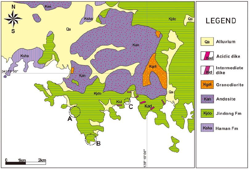
이와 같은 양방향성 고수류를 지시하는 퇴적기록들이 경남 고성군 하이면 덕호리와 덕명리 지역에 분포하는 진동층 퇴적층의 노두와 전석에서 관찰되었다(그림 1). 따라서 이 논문에서는 일반적으로 내륙의 호수퇴적층에서는 발달하기 어려운 이들 양방향성 고수류 기록의 구체적인 산상을 기술하고, 이들의 기원과 고환경적인 의미를 해석하였다. 이 연구결과는 경상분지의 고지리적 특성을 입체적으로 이해하는 데에 새로운 방향을 제시할 수 있을 것으로 기대된다.
2. 지질 개관
진동층은 경상분지 남부의 밀양소분지 퇴적층에서 설정된 지층으로, 경상누층군의 중부 층군인 하양층군의 최상부 지층이다(Chang, 1975). 진동층의 전반적인 층후는 2,000여 m에 이르며, 백악기 말의 화성활동에 의한 화성암류의 관입 또는 분출에 의해 도처에서 혼펠스화 되어 있다(Um et al., 1983). 진동층의 지질시대는 연대측정 자료와 화석, 고지자기 자료 등에 의해 후기 백악기의 초기인 Cenomanian에서 중기인 Campanian에 이르는 것으로 알려져 있다(Kang and Paik, 2012).
진동층은 암층서적으로 붉은색 퇴적층의 빈번한 협재가 일반적인 충적평원 기원의 함안층 상위에 발달하며, 응회질 퇴적층의 발달이 일반적인 유천층군 퇴적층의 하위에 발달한다(Chang, 1975). 이와 함께 경상분지 내에서 진동층과 암층서적으로 대비되는 경상분지 북부 의성소분지의 지층은 건천리층과 반야월층이다(Chang, 1975; Um et al., 1983).
전반적으로 진동층은 암회색 내지 회색을 띠는 엽층리가 잘 발달한 셰일, 실트스톤, 세립사암 등으로 구성되고, 얕은 호수에서 호수연변부(이질평원 내지 사질평원)에 이르는 환경에서 형성된 것으로 해석되었으며, 이들 퇴적층이 반복되어 나타나는 것이 특징이다(Um et al., 1983; Kim and Paik, 2001; Paik et al., 2001; Chough and Sohn, 2010). 이와 함께 진동층에서는 소금과 석고 등 증발 기원 광물의 캐스트들이 드물지 않게 발달되어 있어, 퇴적 당시 경상분지 내에 부분적으로 염호가 발달했음을 지시해 준다(Paik et al., 2001).
한편 진동층은 한반도 공룡시대의 지층 중 공룡발자국화석이 가장 많이 산출된 지층으로(Yang, 1982; Lim et al., 1989; Paik et al., 2001; Huh et al., 2003; Lockley et al., 2006), 공룡의 행동 특성을 이해하는 데에 매우 유용한 정보를 보유한 지층이다. 이와 함께 진동층에서는 새발자국화석(Lockley et al., 1992; Kim et al., 2008)과 무척추동물 생흔화석이 나타나나, 체화석의 산출은 극히 제한적이며(Chi et al., 1983), 식물화석의 산출 또한 매우 드물다(Kimura, 2000).
양방향성 고수류의 퇴적기록이 확인된 연구지역에는 암층서적으로 진동층의 하부(덕호리 지역) 및 중하부(덕명리 지역)에 해당하는 퇴적층이 분포되어 있다(Chi et al., 1983).
3. 양방향성 고수류 기록
이 연구를 통해 진동층 퇴적층의 노두와 전석으로부터 확인된 양방향성 고수류 기록들의 발달 특성은 다음과 같다.
3.1 고성군 하이면 덕호리 지역
이 지역의 진동층 퇴적층에서는 토목공사 과정에 산출된 전석들의 퇴적단면에서 양방향성 고수류 기록이 관찰되었다.
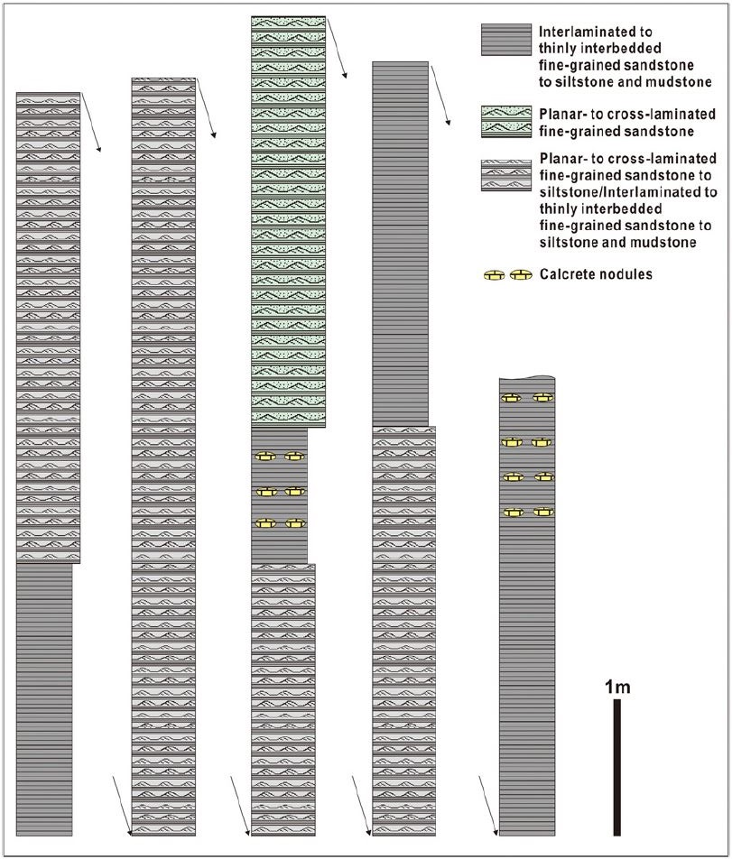
이 지역에 분포되어 있는 진동층 퇴적층은 진동층의 하부에 해당하며(그림 1), 관입작용의 영향을 받아 대체적으로 혼펠스화 되어 있다. 이 퇴적층들은 전반적으로 호수연변부 환경(사질평원과 이질평원 등)에서 퇴적된 엽층 내지 얇은 층으로 발달한 세립사암 내지 실트스톤과 이암의 호층, 판상 내지 사엽층리가 발달한 세립사암 내지 실트스톤, 이암엽층으로 피복된 사구상으로 발달한 중립 내지 세립사암, 점이층리를 이루는 중립 내지 세립사암, 점이층리를 이루는 중립 내지 세립사암과 이암 엽층의 교호암, 응회질의 역질사암 등의 암상과 천호 기원의 석회질의 실트질 이암으로 이루어져 있으며(그림 2), 이 중 가장 우세한 퇴적층은 이질평원 기원의 엽층 내지 얇은 층으로 발달한 세립사암 내지 실트스톤과 이암의 호층이다(Kim and Paik, 2001). 한편 일부 퇴적층에서는 고토양 기원의 탄산염 단괴, 렌즈 또는 층이 나타난다(그림 2).
이들 퇴적층에서는 간섭연흔, 건열의 중첩, 티피구조, 우흔, 저면구조, 미생물기원 퇴적구조(Microbially induced sedimentary structures: MISS) 등 다양한 특성의 퇴적구조들(그림 3a-e)이 관찰된다. 이 지역 퇴적층에서 체화석의 산출은 확인되지 않으나, 공룡발자국, 새발자국, Cochlichnus ichnosp. (그림 3f), Diplocraterion ichnosp. 등의 생흔화석이 관찰된다.
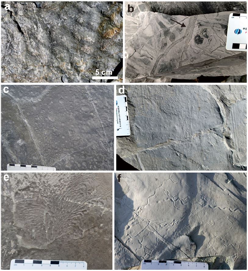
Sedimentary structures observed in the Jindong Formation at Deokhori site. a. Interference ripples. b. Vertical stratification in infilling sediments in mudcracks (arrow) by the repetition of shrinkage and infilling. c. Raindrops. d. Groove casts. e. Wrinkle marks (one of MISS). f. Cochlichnus ichnosp.
엽층 내지 얇은 층으로 교호하는 세립사암 내지 실트스톤과 이암의 퇴적층과 교호되어 발달된 10 cm 내외 두께의 세립사암 내지 실트스톤 퇴적층의 퇴적단면에서 고수류의 방향이 발달 층준에 따라 서로 반대되는 양상이 관찰된다(그림 4). 사엽층리는 유수연흔 내에 발달되어 있으며, 대체로 사엽층리의 경사각은 20 내지 30도 내외, 유수연흔의 파장은 5 내지 10 cm 내외를 보인다.
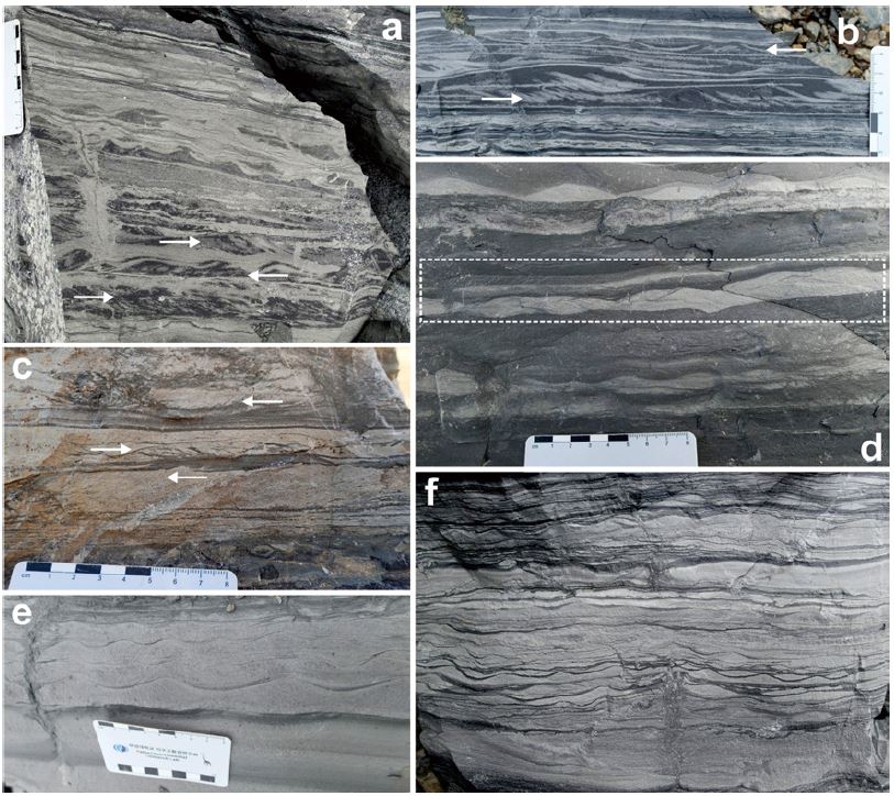
Bidirectional paleocurrent records (a-d) and flaser, wavy to lenticular bedding (e, f) observed in the in the Jindong Formation at Deokhori site. a-c. The paleocurrent (arrows) in the current ripples are in opposed direction. d. Herring-bone cross-lamination (dotted box) e. Flaser bedding. f. Flaser, wavy to lenticular bedding.
사엽층리가 발달된 유수연흔 아래에 침식기저면을 가지는 판상엽층리 퇴적층이 점이적인 관계를 가지며 발달된 양상이 일반적으로 나타나며, 이 경우 침식기저면 하위에 발달된 사엽층리의 경사방향과 상위에 놓인 사엽층리의 경사방향은 서로 반대 방향을 보인다(그림 4a). 이러한 특성이 발달되어 있는 경우, 일부 퇴적단면에서는 청어뼈(herring-bone) 사엽층리의 특성이 나타난다(그림 4d). 반면 사엽층리 발달 유수연흔이 2 내지 3회 연속되어 나타나는 경우에는 각각의 경계부에 침식기저면을 가지는 판상엽층리의 발달 없이 유수연흔이 중첩되어 있으며, 이 경우 유수연흔 내 사엽층리의 경사방향은 동일한 방향으로 발달하는 경향을 보인다. 전반적으로 사엽층리 퇴적층의 두께는 1 내지 2 cm 내외, 판상엽층리 퇴적층의 두께는 수 mm의 규모를 보인다.
한편 이 지역의 퇴적층에서는 전술한 양방향성 사엽층리의 발달 이외에, 우상층리, 파형층리(wavy bedding), 렌즈형층리(lenticular bedding) 등이 엽층 내지 얇은 층으로 교호하는 세립사암 내지 실트스톤과 이암의 퇴적층과 수반되어 있는 세립사암 내지 실트스톤 퇴적층에서 드물지 않게 관찰된다(그림 4e, 4f).
3.2 고성군 하이면 덕명리 지역
이 지역에는 대체로 진동층의 중하부에 해당하는(그림 1) 퇴적층이 해안을 따라 단속적으로 노출되어 있으며, 일부 지역 노두의 퇴적단면과 성층면에서 양방향성 고수류 기록이 관찰된다.
이 지역에는 전술한 덕호리 지역의 진동층과 마찬가지로 전반적으로 호수연변부에서 천호에 이르는 환경의 퇴적층이 반복되어 발달되어 있다. 이 중 가장 우세한 퇴적층은 호수주변 이질평원 기원의 엽층 내지 얇은 층으로 발달한 세립사암 내지 실트스톤과 이암의 호층이며, 간헐적으로 판상 내지 사엽층리가 발달한 세립사암 내지 실트스톤이 협재되어 있다. 이 지역의 퇴적층 구성은 Kim and Paik (2001)과 Paik et al. (2001)의 논문에 상세히 제시되어 있다. 한편 Houck and Lockley (2006)는 이 지역의 진동층 퇴적층에 화산쇄설퇴적물의 함유가 일반적인 것으로 보고하였으며, 고지진 기원의 쇄설성 퇴적암맥과 연성퇴적변형구조 등이 일부 지역의 진동층 퇴적층에서 관찰된다.
이 지역의 진동층 퇴적층에서는 소형 복족류 화석과 개형충 화석 등이 매우 드물게 산출하는 것을 제외하고는 체화석의 산출이 매우 제한적이나, Skolithos 등의 무척추동물 생흔화석이 일부 퇴적층에서 집중적으로 산출된다. 한편 이 지역의 진동층 퇴적층에서는 조각류, 용각류, 수각류 등의 다양한 공룡 발자국화석이 반복적으로 산출되어(Yang, 1982; Lim, 1990; Lim et al., 1994), 이 지역의 해안 일대는 1999년에 천연기념물 제 411호로 지정된 바 있으며, 새발자국화석도 부분적으로 산출된다(Lockley et al., 1992). Paik et al. (2001)은 이 지역 산출 공룡발자국화석들의 화석화과정 연구를 통해 공룡발자국화석의 반복적인 산출이 가뭄 시기에 공룡들이 물을 먹기 위해 호수를 반복적으로 방문한 결과인 것으로 해석하였다.
덕명리 제전마을: 이 지역 해안에 노출되어 있는 셰일(세립사암 내지 실트스톤과 이암의 교호엽층) 내지 셰일질이암(그림 5a)에 수반되어 있는 10 cm 내외 두께의 세립사암 내지 실트스톤 퇴적층의 퇴적단면에서 전형적인 특성을 가지는 우상층리, 파형층리, 렌즈형층리 등이 관찰된다(그림 5b, 5c). 이 층리에는 유수연흔이 반복되어 나타나며, 이들 유수연흔 단면에서 고수류의 방향이 발달 층준에 따라 서로 반대되는 기록이 나타난다(그림 5d, 5e). 일부 유수연흔의 기저에는 판상의 이암편들(두께 1 mm 미만, 길이 1 cm 내외에서 수 mm)이 대체로 층리에 평행하게 산재되어 배열된 양상이 나타나며, 일부 이암편들은 미약한 인편배열(imbrication)을 보인다(그림 5e).
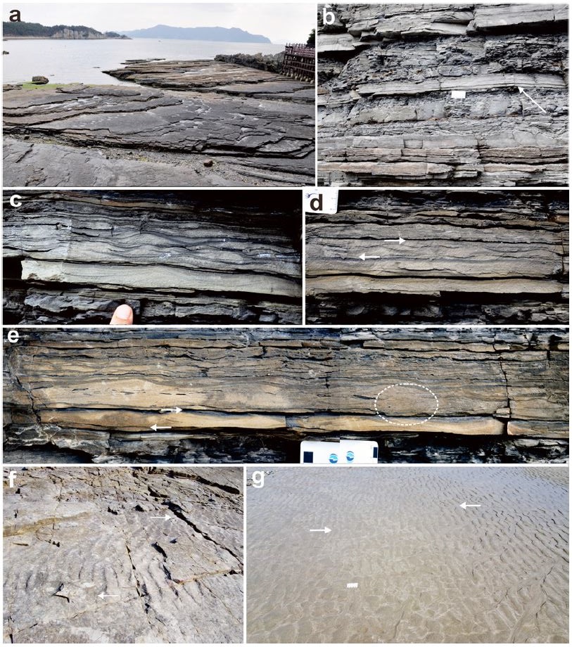
Fig. 5. Bidirectional paleocurrent records observed in the lake margin deposits of the Jindong Formation at Jejeonmaeul site (a-e) and Silbawi site (f) in Deokmyeongri. a. Panoramic view of Deokmyeongri site in which lake margin deposits with dinosaur footprints are well exposed. b. Sectional view of lake margin deposits consisting of interlaminated to thinly interbedded fine-grained sandstone to siltstone and mudstone beds with intermittently intercalated planar- to cross-laminated fine-grained sandstone to siltstone beds. The bidirectional paleocurrent record-bearing fine-grained sandstone to siltstone bed is indicated by arrow. c. Flaser bedding. d. The paleocurrent (upper arrow) of a superposed current ripple is in opposed direction to that (lower arrow) of underlying current ripple. e. In the left the paleocurrent (upper arrow) of a superposed current ripple is in opposed direction to that (lower arrow) of underlying current ripple, and in the right herring-bone cross-lamination (dotted ellipse) is observed. f. Laterally opposed dip directions (arrows) of the lee-sides along the crest-lines are observed on the bedding surface. g. Opposed dip directions (arrows) of the lee-sides normal to the shoreline are observed on the modern tidal flat.
유수연흔은 대체로 수 회 중첩되어 나타나며, 유수연흔이 중첩되어 있는 퇴적층 아래에는 침식기저면을 가지는 판상엽층리 퇴적층이 점이적인 관계를 가지며 발달된 양상이 일반적이다. 유수연흔 내에 발달되어 있는 사엽층리의 경사각은 대체로 20도 내외, 유수연흔의 파장은 수 cm에서 10 cm 내외를 보인다. 전반적으로 사엽층리 퇴적층의 두께는 1 cm 내외에서 수 mm를 보이며, 판상엽층리 퇴적층의 두께는 수 mm의 규모를 보인다. 유수연흔 중첩 퇴적층 내에서 사엽층리의 경사방향이 층준을 달리하며 반대로 나타나는 양상이 나타나며, 일부에서는 청어뼈사엽층리의 양상을 띤다(그림 5e). 한편 이 지역의 호수연변부 퇴적층에서 이와 같은 특성을 보이는 퇴적층의 발달은 매우 제한적이다.
덕명리 실바위 해안: 이 지역에 노출되어 있는 세립사암 내지 실트스톤 퇴적층의 성층면에 발달되어 있는 유수연흔에서 양방향성의 고수류 발달을 지시해 주는 특성이 관찰된다(그림 5f). 이 연흔은 아직선 내지 아곡선형의 연흔정선(crest line)을 보이며, 연흔정선의 이분지 양상(bifurcation)이 제한적으로 나타난다. 이 연흔의 파장은 15 cm 내외, 파고는 수 cm 내외를 보인다. 이 유수연흔에 기록된 양방향성의 고수류 특성은 연흔의 내리흐름면(lee side) 방향 변화에서 관찰된다. 즉 동일한 성층면에 발달한 유수연흔의 내리흐름면의 경사방향이 연흔정선의 측방향을 따라 반대로 변화하는 양상이 나타난다(그림 5f). 이와 같은 퇴적기록은 한 방향의 수류에 의해 형성되는 유수연흔에서는 나타날 수 없는 현상으로, 퇴적 당시에 서로 반대되는 양방향의 수류가 동일 퇴적면에 영향을 미쳤음을 지시해 준다.
흥미롭게도 이와 같은 동일 퇴적면에서의 유수연흔 내리흐름면의 경사방향 역전 현상이 덕명리 해안의 사빈에 발달한 아직선형 유수연흔에서 관찰되었다(그림 5g). 이 현상은 썰물 이후에 나타난 것으로, 유수연흔의 육지 쪽 경계부로부터 해안 쪽으로 수 m 나아간 곳 까지는 연흔 내리흐름면의 경사방향이 해안 쪽으로 경사하다가 이후 내리흐름면의 경사방향이 육지 쪽으로 역전되어 있다(그림 5g). 이와 같은 현상은 밀물의 흐름이 다다르는 육지쪽 경계부가 밀물보다는 썰물에 의한 영향을 더 받은 결과로 해석된다.
4. 토 의
앞에서 기술한 진동층 퇴적층 내에서 확인된 양방향성의 고수류 기록들, 그리고 사암 내지 실트스톤과 이암의 교호층에 발달된 우상, 파형, 렌즈형층리 등은 천체 운동의 변화에 따라 동일한 공간에서 시간 변화에 따라 서로 반대되는 방향의 수류가 나타나는 조간대 지역 퇴적층의 특징적인 퇴적구조로 알려져 있다(Reineck and Singh, 1980; Visser, 1980; de Mowbray and Visser, 1984; Nio and Yang, 1989). 실제로 현생 및 지질시대의 조간대 퇴적층으로부터 이와 같은 특성의 퇴적구조가 일반적으로 보고되어 있으며(Van Straaten, 1953; Evans, 1965; Flemming and Bartholoma, 1995; Dalrymple, 2010), 우리나라의 오오도비스기 조간대 퇴적층인 동점규암과 막골층에서 청어뼈사층리(Park, 1992)와 우상 내지 렌즈형층리와 양방향 고수류 기록(Paik, 1987)이 각각 보고된 바 있다.
따라서 이들 보고 자료들만을 적용할 경우, 진동층의 퇴적에 밀물과 썰물의 영향이 있었던 것으로 의심될 수 있으며, 전술한 덕명리 해빈에서 관찰된 유수연흔의 내리흐름면 경사방향의 역전현상 또한 이를 뒷받침 한다. 그러나 진동층의 퇴적이 이루어진 경상분지는 내륙의 퇴적분지로 알려져 있고(Um et al., 1983; Choi, 1985; Chough and Sohn, 2010) 진동층에서 해성환경을 지시할 수 있는 화석이 발견된 적이 없으며 지금까지 경상누층군에서 보고된 동식물화석은 대부분 육성기원을 지시하는 것들이다(Lee et al., 2004).
한편 Yabumoto et al. (2006)은 진주층에서 elopiform 및 albuiform 어류(현생의 경우 주로 바다에서 서식) 화석이 산출함을 근거로, 진주층의 퇴적환경이 지형적으로 바다와 가까운 지역이었던 것으로 해석한 바 있으며, Kim et al. (2014)은 진주층에서 산출된 ichthyodectiform의 어류화석이 Hu et al. (2012)이 제시한 전기백악기말 서태평양 지역에서의 해침과 연관이 있을 수 있음을 제시한 바 있다. 그러나 이들 어류 화석을 제외하고는 지금까지 진주층에서 산출되는 동식물화석은 모두 육성기원을 지시한다(Lee et al., 2004).
해성환경이 아닌 육성환경인 경우, 하성퇴적층과 호성퇴적층에서 양방향 수류에 의한 층리가 보고되었다. Alam et al. (1985)은 호주 남서부의 현생 하성퇴적층에서 양방향 수류에 의한 대표적인 층리인 청어뼈사층리를 보고하면서, 이 청어뼈사층리가 하천의 바닥 경사가 낮은 상태에서 홍수 시에 강 본류의 물이 지류와의 합수부에서 지류 쪽으로 일시적으로 역류하며 나타난 결과임을 밝혔다. 한편 Fraser and Hester (1977)는 미국 미시간호의 호안에 형성된 사질퇴적층으로부터 두 가지 유형의 양방향 사층리를 보고하였다. 즉, 한 유형은 호안을 따라 흐르는 연안류의 방향 역전에 따른 것이고, 또 다른 유형은 호안에 발생하는 폭풍파에 의한 수류와 폭풍 종료 후의 평상시 수류의 방향 역전에 따른 것으로 해석하였다(Fraser and Hester, 1977).
대규모 플라야(playa) 호수인 호주 Eyre호의 현생 호안퇴적층에서도 일반적으로 조석변동이나 대조와 소조 변동 등에 의한 결과로 알려져 있는 사층리의 전면층(foreset)들에 발달된 펄피막(mud drape), 사층리 전면층 묶음의 횡적 두께 변화, 쌍으로 발달된 펄피막, 재활성화면(reactivation surface), 청어뼈 사층리, 우상층리, 파형층리, 렌즈형층리 등(Nio and Yang, 1989)이 보고되었다(Ainsworth et al., 2012). Eyre호의 이들 퇴적구조들은 바람 방향의 역전과 속도 변화, 유입수량의 변화 등에 의한 결과로 해석되었다(Ainsworth et al., 2012). 한편 Ainsworth et al. (2012)은 북해 지역의 트라이아스기 플라야호수 퇴적층에서도 이와 같은 조간대 기원의 퇴적구조 발달을 확인하였다.
충적 범위가 114만 km2에 이르는 전 세계에서 가장 큰 내륙분지 중의 하나인 Eyre호 분지는 대표적인 건조지대(연 평균 강우량 125에서 750 mm) 분지로, 열대 몬순의 영향을 받는 남위 19도에서 온대 기후인 남위 39도에 걸쳐 발달되어 있다(Habeck-Fardy and Nanson, 2014). 전반적으로 지형 경사가 매우 낮은 Eyre호 분지에는 하성, 호성, 풍성 등의 퇴적환경이 형성되어 있으며, 저지대에는 수백 내지 수천 km2의 크기를 가지는 여러 개의 염호(salt playa)들이 발달되어 있다(Habeck-Fardy and Nanson, 2014).
전술한 진동층 내에 발달한 사층리의 경우, Eyre호 퇴적층에서 나타나는 사층리 전면층들에 발달된 펄피막과 쌍으로 발달된 펄피막, 사층리 전면층 묶음의 횡적 두께 변화 등이 잘 나타나지는 않으나, 유수연흔 단면에서의 사층리 경사방향 역전, 청어뼈사층리, 성층면에서의 유수연흔 내리흐름면 경사방향의 역전, 우상층리, 파형층리, 렌즈형층리 등의 발달은 진동층의 퇴적과정에 수류의 방향이 역전되는 현상이 존재하였음을 지시해 준다.
전반적으로 호성기원의 퇴적층으로 이루어진 진동층의 경우, 해수면 상승이나 지반 침하 등에 의해 퇴적분지가 일시적으로 바다와 연결되어 조수의 영향을 받음에 따라 양방향성 고수류 기록이 발달하였을 수 있다. 그러나 전술한 양방향성 고수류 기록이 나타나는 퇴적층의 경우, 전반적으로 천해기원 화석이 산출되지 않고 호수연변부 환경의 퇴적층이 반복되어 발달되어 있으므로 이러한 가능성을 배제할 수 있다. 따라서 진동층에 발달된 양방향성의 고수류 기록은 전술한 미국의 미시간호 또는 호주의 Eyre호 퇴적층에 발달된 양방향성 고수류 기록과 유사한 기원으로 해석할 수 있다. 그러나 진동층의 양방향성 고수류 기록이 발달한 퇴적층에 호빈퇴적층의 수반이 부재한 특성은 진동층의 양방향성 고수류 기록의 기원이 미시간호 퇴적층의 양방향성 수류 기록의 기원과는 다름을 지시해 준다.
진동층이 퇴적된 경상분지는 중위도에 위치해 있었으며, 면적이 3만 km2 이상에 달하고, 진동층이 퇴적된 백악기후기에는 산악효과에 의한 건조 기후의 발달에 의해 분지 내에 염호들이 발달하였다(Paik and Kim, 1998, 2006; Paik et al., 2007). 이와 함께 진동층의 경우 심호퇴적층의 수반 없이 호수연변부 퇴적층이 1,000여 m 이상의 두께에 걸쳐 반복되어 나타나므로 퇴적 당시 호수 주변부의 경사가 매우 낮았음을 알 수 있다. 따라서 이와 같은 진동층 퇴적 당시의 경상분지의 환경특성은 진동층에 발달한 양방향성 고수류 기록과 우상층리, 파형층리, 렌즈형층리 등이 Eyre호 분지에서와 같이 호수연변부에서의 바람 방향의 역전과 속도 변화, 호수로의 유입수량 변화 등에 의한 결과일 수 있음을 지시해 준다.
진동층의 퇴적 당시 분지 특성이 Eyre호 분지와 유사성을 가짐은 백악기 후기에 경상분지 내에 플라야 호수의 발달을 시사해 주며, 이에 대한 증거는 Paik and Kim (2006)과 Paik et al. (2007)에 의해 제시된 바 있다. 이와 함께 경상누층군 퇴적암이 분포하는 지역의 심부지하수에서 석고 등의 증발암광물과의 반응이 이루어진 현상이 확인됨은(Choi et al., 2012) 경상분지 내에 염호가 발달했음을 뒷받침해 준다.
따라서 현재 지표에 노출되어 있는 진동층의 호수연변부퇴적층에는 증발암광물의 캐스트들만이 나타나지만, 지하심부로 이어진 진동층의 퇴적층에는 호수중심부에서 퇴적된 증발암층이 두껍게 형성되어 있었을 가능성이 매우 높은 것으로 여겨진다. 이는 향후 경상분지를 대상으로 한 유용광물자원의 탐사와 이산화탄소의 지중저장 연구 등에 새로운 관점에서의 접근이 필요함을 시사해 준다.
한편 경상분지에 발달했던 진동층 이외의 호수 기원 지층들(진주층, 진동층과 암층서적으로 대비되는 건천리층과 반야월층)과 소규모 호수 기원의 퇴적층들(낙동층, 하산동층, 함안층 내에 발달된 호소퇴적층), 그리고 경상분지 이외의 백악기 호수퇴적층에서 양방향성의 고수류 기록이나 우상층리, 파형층리, 렌즈형층리 등의 발달이 보고된 바는 없다. 그러나 비록 단편적이지만, 대구층(함안층)에서 양방향성 사층리(그림 6a), 그리고 여수 추도의 백악기 퇴적층에서 우상층리(그림 6b)가 관찰됨은 앞으로 경상분지에 발달했던 호수퇴적층들을 대상으로 이들 퇴적기록들에 대한 고환경적 연구가 수행될 필요성이 있음을 시사해 준다.
5. 결 론
- 1) 일반적으로 조간대 퇴적층에 발달하는 양방향성 고수류 기록과 우상층리, 파형층리, 렌즈형층리 등이 경상누층군 진동층(후기 백악기)의 호수연부퇴적층에서 관찰되었다.
- 2) 후기백악기에 염호가 발달했던 경상분지의 환경 특성과 전반적으로 천해기원 화석의 산출이 부재한 가운데에 호수연변부 환경의 퇴적층이 반복하여 발달된 진동층의 퇴적 특성을 고려할 때, 진동층에 발달한 양방향성 고수류 기록과 우상층리, 파형층리, 렌즈형층리 등은 대규모 건조지대 퇴적분지인 호주 Eyre호 분지에서와 같이 호수연변부에서의 바람 방향의 역전과 속도 변화, 호수로의 유입수량 변화 등에 의한 결과로 해석된다.
- 3) 진동층 퇴적 당시의 분지 특성으로 미루어, 후기백악기에 경상분지에는 플라야호수가 발달한 건조지대가 넓게 형성되어 있었을 것으로 해석되며, 이에 따라 경상누층군이 분포하는 지역의 지하심부에는 증발암층이 두껍게 형성되어 있을 가능성이 있다. 따라서 경상분지 퇴적층에 배태된 유용광물자원의 탐사에 새로운 관점에서의 접근이 필요한 것으로 판단된다.
- 4) 경상분지를 비롯한 한반도 백악기 퇴적분지의 퇴적층에는 아직 기원이 밝혀지지 않은 다양한 특성의 퇴적기록들이 산재해 있으며, 이들 기록에 대한 이해가 이루어질 때 한반도 백악기의 고지형과 고환경 특성 및 진화과정의 실체가 보다 입체적으로 파악될 수 있음은 물론, 이를 바탕으로 한반도 백악기 퇴적지질의 범지구적 중요성이 부각될 수 있을 것이다.
Acknowledgments
이 논문은 부경대학교 자율창의학술연구비(2017년)에 의하여 연구되었으며, 이에 감사드린다. 이 논문의 내용 개선을 위해 유익한 도움말을 주신 두 분의 심사위원님과 최태진 편집위원님께 깊은 감사를 드린다. 이와 함께 덕호리 지역 현장 조사에 도움을 준 (주)건화엔지니어링 관계자분들께도 감사를 드린다.
References
-
Ainsworth, R.F., Hasiotis, S.T., Amos, K.J., Krapf, C.B.E., Payenberg, T.H.D., Sandstrom, M.L., Vakarelov, B.K., and Lang, S.C., (2012), Tidal signatures in an intracratonic playa lake, Geology, 40, p607-610.
[https://doi.org/10.1130/g32993.1]

-
Alam, M.M., Crook, K.A.W., and Taylor, G., (1985), Fluvial herring-bone cross-stratification in a modern tributary mouth bar, Coonambele, New South Wales, Australia, Sedimentology, 32, p235-244.
[https://doi.org/10.1111/j.1365-3091.1985.tb00506.x]

- Chang, K.H., (1975), Cretaceous stratigraphy of southeast Korea, Journal of the Geological Society of Korea, 11, p1-23.
- Chi, J.M., Kim, H.S., Oh, I.S., and Kim, H.C., (1983), Explanatory text of the Geological map of Samcheonpo sheet (1:50,000), Korea Institute of Enerty and Resources, p12.
- Choi, B.Y., Yun, S.T., Mayer, B., Hong, S.Y., Kim, K.H., and Jo, H.Y., (2012), Hydrogeochemical processes in clastic sedimentary rocks, South Korea: A natural analogue study of the role of dedolomitization in geologic carbon storage, Chemical Geology, 306-307, p103-113.
- Choi, H.I., (1985), Sedimentology and its implication for stratigraphic classifications of the Cretaceous Gyeongsang Basin, Journal of the Geological Society of Korea, 21, p26-37.
-
Choi, H.I., (1986), Fluvial plain/lacustrine facies transition in the Cretaceous Sindong Group, south coast of Korea, Sedimentary Geology, 48, p295-320.
[https://doi.org/10.1016/0037-0738(86)90034-5]

-
Chough, S.K., and Sohn, Y.K., (2010), Tectonic and sedimentary evolution of a Cretaceous continental arc-backarc system in the Korean peninsula: New view, Earth-Science Reviews, 101, p225-249.
[https://doi.org/10.1016/j.earscirev.2010.05.004]

- Collinson, J., Mountney, N., and Thompson, D., (2006), Sedimentary Structures (3rd ed), Terra Publiching, England, p292.
- Dalrymple, R.W., (2010), Tidal depositional systems, In: Facies Models 4 James, N.P. (eds., and Dalrymple, R.W. ), St. John’s, Canada, Geological Association of Canada, p201-231.
- de Mowbray, T., and Visser, M.J., (1984), Reactivation surfaces in subtidal channel deposits, Ooster-schedule, southwest Netherlands, Journal of Sedimentary Petrology, 54, p811-824.
-
Evans, G., (1965), Intertidal flat sediments and their environments of deposition in the Wash, Quaternary Journal of the Geological Society of London, 121, p209-240.
[https://doi.org/10.1144/gsjgs.121.1.0209]

- Flemming, B.W., and Bartholoma, A., (1995), Tidal Signatures in Modern and Ancient Sediments, International Association of Sedimentologists Special Pulication, 24, p358.
- Fraser, G.S., and Hester, N.C., (1977), Sediments and sedimentary structures of a beach-ridge complex, southwestern shore of Lake Michigan, Journal of Sedimentary Petrology, 47, p1187-1200.
- Galloway, W.E., and Hobday, D.K., (1996), Terrigenous Clastic Depositional Systems (2nd ed), Springer-Verleg, p489.
- Gottsche, C., (1886), Geologische skizze von Korea, Sitzungsberichte der Koniglich Preussischen, Akademie der Wissenschaften Zu Berlin (1986.07.15), 36, p857-873, (in German).
-
Habeck-Fardy, A., and Nanson, G.C., (2014), Environmental character and history of the Lake Eyre Basin, one seventh of the Australian continent, Earth-Science Reviews, 132, p39-66.
[https://doi.org/10.1016/j.earscirev.2014.02.003]

-
Houck, K.J., and Lockley, M.G., (2006), Life in an active volcanic arc: Petrology and sedimentology of dinosaur track beds in the Jindong Formation (Cretaceous), Gyeongsang Basin, South Korea, Cretaceous Research, 27, p102-122.
[https://doi.org/10.1016/j.cretres.2005.10.004]

- Hu, G., Hu, W., Cao, J., Yao, S., Xie, X., Li, Y., Liu, Y., and Wang, X., (2012), Deciphering the Early Cretaceous transgression in coastal southeastern China: Constraints based on petrography, paleontology and geochemistry, Palaeogeography, Palaeoclimatology, Palaeoecology, 317-318, p182-195.
-
Huh, M., Hwang, K.G., Paik, I.S., Chung, C.H., and Kim, B.S., (2003), Dinosaur tracks from the Cretaceous of South Korea: Distribution, occurrences and paleobiological significance, The Island Arc, 12, p132-144.
[https://doi.org/10.1046/j.1440-1738.2003.00386.x]

-
Jo, H.R., (2003), Depositional environments, architecture, and controls of Early Cretaceous non-marine successions in the northwestern part of Kyongsang Basin, Korea, Sedimentary Geology, 161, p269-294.
[https://doi.org/10.1016/s0037-0738(03)00130-1]

-
Jo, H.R., and Chough, S.K., (2001), Architectural analysis of fluvial sequences in the northwestern part of Kyongsang Basin (Early Cretaceous), SE Korea, Sedimentary Geology, 144, p307-334.
[https://doi.org/10.1016/s0037-0738(01)00123-3]

- Kang, H.C., and Paik, I.S., (2012), Review on the geological ages of the formations in the Gyeongsang Basin, Korea, Journal of the Geological Society of Korea, 49, p17-29, (in Korean with English abstract).
- Kim, H.J., and Paik, I.S., (2001), Sedimentary facies and environments of the Cretaceous Jindong Formation in Goseong-gun, Gyeongsangnamdo, Journal of Geological Society of Korea, 37, p235-256, (in Korean with English abstract).
- Kim, H.J., Paik, I.S., and Huh, M., (2011), Bird footprint-bearing deposits from the Cretaceous Haman Formation in the southern Gyeongsang Basin: occurrences, taphonomy and paleoenvironments, Journal of the Geological Society of Korea, 47, p97-122, (in Korean with English abstract).
-
Kim, H.J., Paik, I.S., Kim, S.Y., and Lee, H., (2018), Sedimentary facies, paleoenvironments, and stratigraphy of the Haman Formation (Early Cretaceous) in Sopo-ri, Haman-gun, Gyeongsangnam-do, Korea, Journala of Geological Society of Korea, 54, p1-19, (in Korean with English abstract).
[https://doi.org/10.14770/jgsk.2018.54.1.1]

- Kim, H.J., Paik, I.S., Lee, J.E., and Huh, M., (2008), Bird footprint fossils from the Upper Cretaceous Jindong Formation at Hogyeri, Masan city, Gyeongsangnamdo, Korea: occurrences and paleoenvironmental implications, Journal of the Geological Society of Korea, 44, p729-745, (in Korean with English abstract).
-
Kim, H.M., Chang, M.M., Wu, F., and Kim, Y.H., (2014), A new ichthyodectiform (Pisces, Teleostei) from the Lower Cretaceous of South Korea and its paleobiogeographic implication, Cretaceous Research, 47, p117-130.
[https://doi.org/10.1016/j.cretres.2013.11.007]

-
Kimura, T., (2000), Notes on the two Early Cretaceous floras in South Korea, Geosciences Journal, 4, p11-14.
[https://doi.org/10.1007/bf02910209]

- Koto, B., (1909), Journeys through Korea, J. Coll. Sci. Imp. Univ., Tokyo, 26-2.
-
Lee, D.W., (1999), Strike-slip fault tectonics and basin formation during the Cretaceous in the Korean Peninsula, Island Arc, 8, p218-231.
[https://doi.org/10.1046/j.1440-1738.1999.00233.x]

- Lee, G.C., Lee, S.J., Choi, D.K., Lee, J.D., Yun, H.S., and Lee, Y.N. (eds.), (2004), Paleonotology of Korea, The Paleontological Society of Korea Spectial Publication No. 7, p458.
-
Lee, J.I., and Lee, Y.I., (2000), Provenance of the Lower Creatceous Hayang Group, Gyeongsang Basin, Southeastern Korea: implications for continental-arc volcanism, Journal of Sedimentary Research, 70, p151-158.
[https://doi.org/10.1306/2dc40906-0e47-11d7-8643000102c1865d]

- Lim, H.S., and Lee, Y.I., (2005), Cooling history of the Upper Cretaceous Plagongsan Granite, Gyoengsang Basin, SE Korea and its tectonic implication for uplift on the active continental margin, Tectonophysics, 403, p151-165.
- Lim, S.K., (1990), Trace fossils of the Cretaceous Jondong Formation, Koseong, Korea, PhD thesis, Kyungpook National University, p126, (in Korean with English abstract).
- Lim, S.K., Lockley, M.G., Yang, S.Y., Fleming, R.F., and Houck, K., (1994), A preliminary report on saurpod tracksites from the Cretaceous of Korea, Gaia, 10, p109-117.
- Lim, S.K., Yang, S.Y., and Lockley, M.G., (1989), Large dinosaur footprint assemblages from the Cretaceous Jindong Formation of southern Korea, In: Dinosaur Tracks and Traces Gillette, D.D. (eds., and Lockley, M.G. ), Cambridge University Press, Cambridge, p333-336.
-
Lockley, M.G., Houck, K., Yang, S.Y., Matsukawa, M., and Lim, S.K., (2006), Dinosaur-dominated footprint assemblages from the Cretaceous Jindong Formation, Hallyo Haesang National Park area, Goseong County, South Korea; evidence and implications, Cretaceous Research, 27, p70-101.
[https://doi.org/10.1016/j.cretres.2005.10.010]

-
Lockley, M.G., Yang, S.Y., Matsukawa, M., Fleming, R.F., and Lim, S.K., (1992), The track record of Mesozoic birds: evidence and implications, Philosophicla Trans-actions of Royal Society of London, Bulletin of Biologicla Science, 336, p113-134.
[https://doi.org/10.1098/rstb.1992.0051]

- Nio, S.D., and Yang, C.S., (1989), Recongnition of tidallyinfluenced facies and environments, Short Course Note Series I, Leiderdorp, Netherlands, InterGeos, p83.
- Paik, I.S., (1987), Depositional environments of the Middle Ordovician Maggol Formation, southern part of the Baegunsan Syncline Area, Journal of the Geological Society of Korea, 23, p360-373.
- Paik, I.S., Huh, M., So, Y.H., Lee, J.E., and Kim, H.J., (2007), Traces of evaporites in the Upper Cretaceous lacustrine deposits of Korea: origin and paleoenvironmental implications, Journal of Asian Earth Sciences, 30, p93-107.
-
Paik, I.S., and Kim, H.J., (1998), Subaerial lenticular cracks in Cretaceous lacustrine deposits, Korea, Journal of Sedimentary Research, 68, p80-87.
[https://doi.org/10.2110/jsr.68.80]

-
Paik, I.S., and Kim, H.J., (2006), Playa lake and sheetflood deposits of the Upper Cretaceous Jindong Formation, Korea: Occurrences and palaeoenvironments, Sedimentary Geology, 187, p83-103.
[https://doi.org/10.1016/j.sedgeo.2005.12.006]

-
Paik, I.S., Kim, H.J., and Lee, Y.I., (2001), Dinosaur track-bearing deposits in the Cretaceous Jindong Formation, Korea: occurrence, palaeoenvironments and preservation, Cretaceous Research, 22, p79-92.
[https://doi.org/10.1006/cres.2000.0241]

- Park, Y.A., (1992), Petrology of silica cementation in some sandstone of the Dongjeom Quartzite, Joseon Supergroup, Sangdong Region, Kwangweondo, Korea, Journal of the Geological Society of Korea, 28, p264-272.
-
Reineck, H.E., and Singh, I.B., (1980), Depositional Sedimentary Environments, Springer-Verlag, New York, p549.
[https://doi.org/10.1007/978-3-642-81498-3]

- Um, S.H., Choi, H.I., Son, J.D., Shin, S.C., and Yun, H.S., (1983), Geological and Geochemical studies on the Gyeongsang Supergroup in the Gyeongsang Basin, Korea Institute of Energy and Resources Bulletin, 36, p124, (in Korean with English abstract).
- Van Straaten, L.M.J.U., (1953), Rhythmic patterns on Dutch North Sea beaches, Geologie en Mijnbouw, 2, p31-43.
-
Visser, M.J., (1980), Neap-spring cycles reflected in Holocene subtidal large-scale bedform deposits: A preliminary note, Geology, 8, p543-546.
[https://doi.org/10.1130/0091-7613(1980)8<543:ncrihs>2.0.co;2]

- Yabumoto, Y., Yang, S.Y., and Kim, T.W., (2006), Early Cretaceous freshwater fishes from Japan and Korea, Journal of Paleontological Society of Korea, 22, p119-132.
- Yang, S.Y., (1982), On the Dinosaur’s Footprints from the Upper Cretaceous Gyeongsang Group, Korea, Journal of the Geological Society of Korea, 18, p37-48, (in Korean with English abstract).

