구조운동과 화산활동에 의해 조절된 장기분지 성동리층 하부의 퇴적 환경 변화

Copyright © 2018 The Geological Society of Korea
This is an Open Access article distributed under the terms of the Creative Commons Attribution Non-Commercial License (http://creativecommons.org/licenses/by-nc/3.0/) which permits unrestricted non-commercial use, distribution, and reproduction in any medium, provided the original work is properly cited.
초록
장기분지의 성동리층은 데사이트질 화산쇄설물과 하천 및 호수환경에서 퇴적된 쇄설성 퇴적물이 교호한다. 분지 전반에 걸쳐 산출되는 화산쇄설물과 퇴적계의 전진 및 후퇴 양상을 통해, 5개의 시추코어와 육상 노두의 성동리층 하부를 대비하여 6개의 퇴적단위로 구분하였다. 퇴적단위 S-1은 응회암, 상향세립화 경향을 보이는 역암 그리고 괴상 및 엽층리를 보이는 이암 등으로 구성된다. 이는 화산활동으로 다량의 퇴적물이 공급되어 하성환경이 조성된 후 분지침강이 일어나 호성 환경이 형성되었음을 지시한다. 퇴적단위 S-2는 서쪽의 장기 1, 4호공에서 역질 퇴적물이 약 80 m로 두껍게 분포하나, 동쪽의 장기 3, 5, 6호공에서는 상대적으로 세립질이고 약 30 m에 불과하다. 이는 분지 서쪽에서 정단층 운동으로 퇴적수용공간이 많이 형성되었지만 다량의 퇴적물이 공급되어 망상하천 및 습지환경이 유지된 것으로 해석된다. 퇴적단위 S-3은 장기 1, 4, 6호공에서 약 50 m 두께로 하성환경에서 재동된 응회질 퇴적암이 발달해 있고, 장기 3, 5호공에서는 약 75 m 두께로 상향조립화 경향을 보이는 호수로 전진구축하는 퇴적계가 분포한다. 이러한 변화는 장기 3호공과 6호공 사이의 정단층 운동을 지시한다. 퇴적단위 S-4는 데사이트질 화산력 응회암 및 쇄설성 퇴적암으로 구성되어있다. 응회암이 주로 괴상이며 탄화목이 분포하는 것으로 보아 육상에서 분출한 화쇄류에 의한 것으로 보인다. 퇴적단위 S-5는 약 70 m의 화산쇄설물로 구성되어있으며, 하부에 유리질 화산회가 결여되어있고 내부균열을 보이는 결정, 탄화목 및 부가화산력 등으로 보아 육상에서 분출된 화쇄류가 수중환경에서 퇴적된 것으로 해석된다. 퇴적단위 S-6의 두꺼운 엽리상 이암은 화산활동 이후 분지 전반이 침강하여 시추공 인근까지 조립질 퇴적물이 공급되지 않는 대규모 호수가 형성되었음을 지시한다. 성동리층 하부의 6개 퇴적단위 내부에서 나타나는 퇴적상 변화와 두께 차이는 지구조 운동과 이와 관련된 화산활동 및 퇴적물 공급량 변화에 의해 조절된 것으로 해석된다.
Abstract
The Seongdongri Formation in the Janggi Basin is composed of dacitic volcaniclastic and clastic sediments, deposited in fluvial and lacustrine environments. In the cores, individual beds of volcaniclastic sediments and the patterns of depositional systems were used for correlation. Prograding and retrograding patterns of depositional systems were also used for correlation. Based on these features, the lower part of the Seongdongri Formation can be divided into six depositional units. The Unit S-1 is composed of dacitic tuff, conglomerate beds showing a fining-upward trend, and massive and laminated mudstones with thin, graded sandstones, in ascending order. The vertical succession suggests a volcanic eruption and high rates of volcaniclastic sediment supply, resulting in the deposition of fluvial sediments. The basin was, then, subsided rapidly, depositing thick mudstones in lacustrine environments. In the western part of the basin (JG-1, -4 wells), the Unit S-2 is composed of thick (∼80 m) conglomerates and gravelly sandstones, interpreted as gravelly braided stream deposits. In the eastern part (JG-3, -5, -6 wells), however, relatively thin (< 30 m) mudstones were deposited in lake or lake margin environments. Rapid subsidence along the western boundary fault resulted in the westward tilting of the basin. However, deposition of braided stream and swamp sediments suggests high rate of sediment supply. In Unit S-3, JG-1, -4, -6 wells are represented by 50 m thick resedimented volcaniclastic rocks showing fining-upward trends, deposited in braided stream environments. The JG-3, -5 wells, however, comprise thick (< 75 m) mudstone, muddy sandstone and fine sandstone with a coarsening-upward trend, representing a prograding depositional system to the lake environment. The abrupt changes can be interpreted as activation of a normal fault between JG-3 and -6 wells. The Unit S-4 is composed of thick dacitic tuffs and clastic sediments. Massive feature, abundant ash matrix, and carbonized wood fragments in the dacitic tuffs are indicative of deposition by pyroclastic density currents. The Unit S-5 is composed of 70 m thick dacitic volcaniclastic rocks. Fractured crystals in lapilli tuffs, ash-depleted matrix in the lower part of the tuff, carbonized wood fragments and accretionary lapilli suggest deposition by pyroclastic density currents entering into subaqueous environments that were generated from subaerial eruption. The Unit S-6 is dominated by thick laminated mudstones, suggesting sediment depleted lacustrine environments after the volcanic eruptions. Variations in sedimentary facies and thickness in each depositional unit suggest that sedimentary architecture and depositional environments were controlled by tectonic subsidence and related volcanic activities, resulting in rapid variation of sediment supply rate.
Keywords:
Janggi Basin, Seongdongri Formation, sedimentary facies, volcanic eruption, tectonic subsidence키워드:
장기분지, 성동리층, 퇴적상, 화산활동, 구조운동1. 서 론
한반도 남동부에 분포하는 전기 마이오세 퇴적분지의 지층은 쇄설성 퇴적암, 화산암 그리고 화산쇄설암으로 구성되어있다(Bahk and Chough, 1996; Ki 2009; Kwon et al., 2011; Jung et al., 2012; Sohn et al., 2013). 이는 퇴적분지들이 형성 및 확장될 당시에 화산활동이 수반되었음을 지시하고, 이러한 화산활동에 의해 형성된 화산암 및 화산쇄설암은 분지의 침강 및 퇴적사를 밝히는데 중요한 정보를 제시한다(Busby and Bassett, 2007; Jeong et al., 2008; Kwon et al., 2011; Sohn et al., 2013). 특히, 화산쇄설암은 폭발적인 분출에 의해 형성되어 분지 전반에 걸쳐 광범위하게 퇴적되므로, 퇴적층 대비의 건층(key bed) 역할을 한다(Brown and Branney, 2004; Jeong et al., 2008). 화산퇴적물의 대비를 통해 퇴적분지 내에서 동일 시기에 형성된 퇴적층의 지역적인 퇴적환경 변화와 두께 변화를 확인하면, 이러한 변화를 유발한 분지의 구조운동 및 퇴적물 공급량 변동을 밝힐 수 있으며 이를 통해 분지의 퇴적사를 복원할 수 있다(Shanley and McCabe, 1994; Ethridge et al., 1998).
전기 마이오세의 장기분지에서는 여러 차례 퇴적학적 연구들이 수행되었으나, 기존 연구는 대부분 분지 가장자리에 분포해 있는 노두를 대상으로 하였다(Bahk and Chough, 1996; Ki, 2009; Son et al., 2013). 특히, 쇄설성 퇴적물과 화산쇄설물의 교호층으로 구성된 성동리층의 육상 노두는 차별침식 및 풍화, 그리고 단속적으로 나타나는 노두에 의해 화산쇄설물의 광역적 대비가 제한적이어서 분지 충진사를 밝히는데 어려움이 있었다(Kim et al., 2011, 2015). 그러나 최근 이산화탄소 지중저장을 위해 장기면 학계리와 신계리에서 시추된 5개의 시추코어는 장기분지에서 분출된 모든 화산쇄설물을 암상, 색, 퇴적상 그리고 상하부에 분포하는 쇄설성 퇴적층의 퇴적상 등을 통하여 대비할 수 있었다. 화산쇄설물로 구성된 건층과 함께 분지의 침강률 및 퇴적물 공급량 변화에 따른 퇴적계의 전진과 후퇴를 기준으로 지층을 대비하는 육상 순차층서의 개념도 지층의 대비와 분지 발달사를 밝히는데 유용하게 이용된다(Lee and Hwang, 2012; Gim et al., 2016; Gu and Hwang, 2017). 본 연구에서는 성동리층 하부 퇴적층을 화산쇄설물과 육상순차층서를 통하여 대비하였고, 이를 통하여 6개의 퇴적단위로 구분하였다. 퇴적상 분석을 통하여 퇴적환경을 밝히고 각 퇴적단위의 두께 변화와 퇴적환경의 지역적인 변화를 통해 시기별로 이를 유발한 분지의 구조운동과 화산활동의 연관성을 고찰하였다.
2. 지질개요
장기분지는 전기 마이오세 퇴적분지로서, 한반도 남동부에 위치한 여러 마이오세 분지(포항, 어일, 와읍, 하서, 정자)와 동일한 당겨열림(pull-apart) 분지로 알려져 왔다(Kim et al., 2011; Sohn et al., 2013; Son et al., 2013). 야외조사에 의한 분지충전물 연구를 통해, 장기분지는 구룡포, 오천, 뇌성산, 영암리 지괴 및 양포 소분지로 구분되었고, 분지 충전물은 하부로부터 쇄설성 퇴적암으로 구성된 장기역암, 데사이트질 응회암과 응회질 퇴적암, 쇄설성 퇴적암이 교호하는 성동리층 그리고 현무암 및 응회질 퇴적암으로 구성된 뇌성산 현무암질암으로 구분된다(Kim et al., 2011, 2015)(그림 1). 이러한 퇴적암의 조성에 따른 분지 충전물의 층서는 뇌성산지괴의 시추코어에서도 동일하게 나타난다(Gim et al., 2016; Gu and Hwang, 2017)(그림 2). 또한, 화산암 및 관입암에 대한 K-Ar 및 Ar-Ar 절대연령 연구를 통해 분지충전물은 약 23 Ma에서 18 Ma 사이에 퇴적된 것으로 보고되었고(Lee et al., 1992; Kim et al., 2005), 이 시기는 대체로 온난하고 습윤한 기후가 유지되었음이 화분포자와 나무 화석의 연구결과로 밝혀졌다(Chung and Choi, 1993; Kim et al., 2008; Paik et al., 2011).

Detailed geological map of the Janggi Basin with the locations of well sites (modified from Kim et al., 2015). Note line a-a’ showing the location of outcrops in the Yeongamri Block.

Simplified columnar section of Janggi Basin cores (Gu and Hwang, 2017). The basin fill deposits can be divided into the Janggi Conglomerate, the Seongdongri Formation and the Noeseongsan Basaltic Rocks in ascending order. For the locations of wells, see Fig. 1.
장기분지에서 수행된 기존의 퇴적학적 연구는 노두와 시추코어를 통해 이루어졌다. Bahk and Chough (1996)은 장기면 영암리 일대에 분포한 노두를 통해, 화산분출 동시성 화산쇄설암과 화산활동 휴지기 동안 퇴적된 하성 퇴적물이 교호하고 있음을 밝혔고, Sohn et al. (2013)은 양포 소분지의 노두에서 고수류 방향 연구를 통해 화산쇄설암과 역질 하성 퇴적물은 각각 동쪽과 남쪽에서 공급되었음을 확인하였다. 또한, 화산활동 휴지기(intereruption period)에 하성환경이 오랫동안 지속되었으나 기존의 화산쇄설암을 대규모로 침식시켰던 흔적과 고토양(paleosol)이 발견되지 않는 점을 통해, 화산쇄설암과 교호하는 하성퇴적암은 분지의 대규모 침강에 따른 퇴적물 공급량의 증가에 의한 것으로 해석하였다. Gim et al. (2016)은 뇌성산 지괴에서 회수된 시추코어의 성동리층 중부에 분포하는 약 150 m 두께의 데사이트질 화산쇄설암의 대비와 암상 기재를 통하여, 육상에서 분출한 화쇄류가 육상에서 퇴적된 후 재동되었으며, 이후 분지가 침강하여 화쇄류는 수중에서 퇴적되었음을 밝혔다. Gu and Hwang (2017)은 시추코어의 장기역암을 연구하여, 분지의 구조운동에 따른 퇴적수용공간 및 퇴적물 공급량 변동에 따른 퇴적환경의 변화를 해석하였다.
3. 연구대상
본 연구는 포항시 남구 장기면 학계리와 신계리에서 이산화탄소 지중저장 실증을 목적으로 회수된 5개의 시추코어(JG-1, 3, 4, 5, 6)를 이용하였다(그림 1). 본 연구 대상인 성동리층 하부는 약 7 m 두께의 데사이트질 응회암이 출현하는 구간부터, 두께 약 150 m의 데사이트질 응회암 및 응회질 퇴적암과 이를 덮고 있는 호성이암까지 해당된다(그림 3). 이 구간은 화산활동의 영향이 미약했던 장기역암과 달리, 수 cm에서 수십 m 두께의 응회암이 여러 층준에서 관찰되는 것으로 보아 화산활동이 빈번했던 것으로 추정되며(Gu and Hwang, 2017), 화산쇄설물의 대비를 통해 화산활동과 구조운동에 의한 장기분지 퇴적환경의 변화를 규명하는데 유용할 것으로 보인다.

Schematic columnar sections of the lower part of the Seongdongri Formation. Based on volcanic eruption events and laterally continuous lacustrine deposits, the lower part of the Seongdongri Formation can be divided into 6 depositional units.
4. 퇴적단위 대비 및 해석
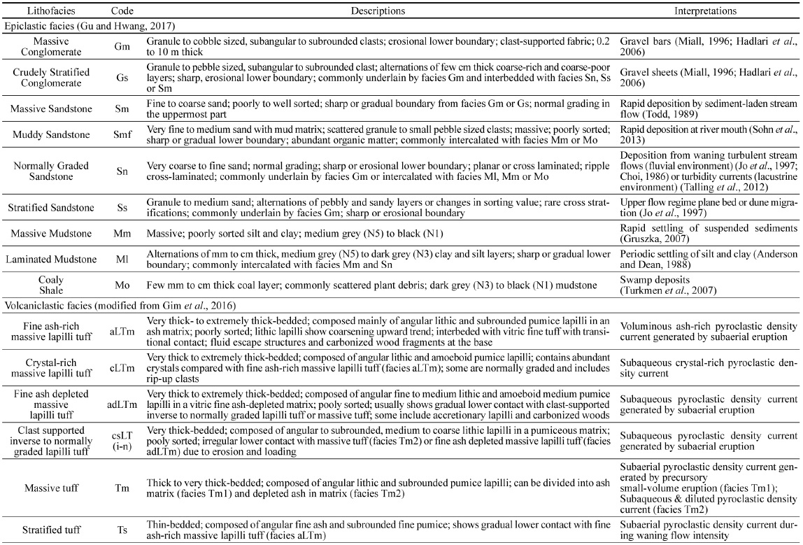
Gim et al. (2016)과 Gu and Hwang (2017)은 장기분지에서 채취된 시추코어에서 암상, 입도, 퇴적구조 등의 특징을 관찰하여 장기역암과 성동리층 하부의 퇴적물을 9개의 쇄설성 퇴적상과 6개의 화산쇄설성 퇴적상으로 구분하였다. 본 연구에서는 기존에 구분된 퇴적상을 기준으로 퇴적작용을 해석하였으며, 각각의 특징과 해석을 표 1에 정리하였다.

Description and interpretation of lithofacies in the lower part of the Seongdongri Formation (modified from Gim et al., 2016, Gu and Hwang, 2017)
성동리층 하부에는 쇄설성 퇴적층 사이에 화산쇄설물이 교호하며, 시추코어는 육상의 노두와는 달리 95%의 이상의 회수율을 보여 이 시기에 분출하여 퇴적된 모든 화산쇄설물을 관찰할 수 있었다. 또한 각 시추공 사이의 거리가 300 m - 1,100 m에 불과하여 두께 수 cm 내외의 얇은 화산재 퇴적층도 암상, 색, 퇴적상, 상하부에 분포하는 쇄설성 퇴적층의 퇴적상을 근거로 인근 시추공 간 비교 및 대비가 가능하였다. 화산쇄설물 사이의 쇄설성 퇴적물은 Gu and Hwang (2017)이 장기역암층 내부에서 퇴적단위 대비에 사용한 육상순차층서의 개념을 도입하여 분지의 침강률 및 퇴적물 공급량 변화에 따른 퇴적계의 전진과 후퇴를 고찰하여 대비하였다. 이를 바탕으로 성동리층 하부를 총 6개의 퇴적단위로 구분하였다(그림 3). 퇴적단위 S-1은 장기분지에서 최초로 나타나는 데사이트질 응회암과 상부의 이질 퇴적체로 구성되어있다. Kim et al. (2011, 2015)은 장기분지에서 처음으로 산출되는 이 응회암에 대한 현미경 분석을 수행하였고 장기분지에서 장기역암과 성동리층의 경계로 획정한 바 있다. 퇴적단위 S-1과 S-2의 경계는 이질 퇴적체와 침식경계를 보이는 조립질 역암에 의해 구분된다. 이 경계는 시추공에서 뿐만 아니라 육상의 노두에서도 뚜렷이 확인된다. 퇴적단위 S-3은 두 번째로 나타나는 최대 7 m 두께의 데사이트질 응회암과 상부의 재동된 응회질 퇴적물로 구성되어 쇄설성 퇴적암으로 구성된 퇴적단위 S-2와 구분된다. Gim et al. (2016)은 그 상부에 발달해있는 약 150 m 두께의 데사이트질 응회암에 대해 현미경 분석 및 전자현미분석 등을 통한 암상분석과 함께 화산쇄설물의 퇴적상을 구분하였고, 수평적, 수직적 암상 및 퇴적상 변화를 고찰하여 4개의 퇴적단위로 구분하였다. 퇴적단위 1은 화산쇄설암으로 구성되어 있으며, 화산회 기질지지, 괴상, 분급불량, 탄화목, 탈유체구조, 연한 붉은색 기질 등의 특징으로 육상에서 분출된 화쇄류암으로 해석하였고, 그 상부의 퇴적단위 2는 상향세립화 경향을 보이는 역암, 사암, 이암으로 구성된 하성퇴적물로 해석하였다(Gim et al., 2016). 퇴적단위 3, 4의 화산력 응회암은 기질에 유리질 화산회가 결여되어 있으며, 탄화목, 부가화산력 및 내부 균열을 가진 결정이 분포하는 점으로 보아 육상 화산활동으로 형성된 화산쇄설성 밀도류가 수중에서 퇴적된 것으로 해석하였다(Gim et al., 2016). 본 연구에서는 퇴적단위 1, 2가 육상에서 퇴적된 점과, 퇴적단위 3, 4에서 암상의 급격한 변화가 없이 수중에서 퇴적된 점을 근거로 퇴적단위 1, 2와 3, 4를 각각 퇴적단위 S-4와 S-5로 구분하였다. 퇴적단위 S-6은 두꺼운 화산쇄설물 상부에 분포하는 두께 10 m 이상의 엽리상 이암으로 구성되어 있다. 시추 코어에서 확인되는 두께 수 cm 내외의 얇은 화산재 퇴적층은 각 퇴적단위 내에서 세부 대비에 활용되었다.
4.1 퇴적단위 S-1
기재 : 퇴적단위 S-1은 데사이트질 응회암과 응회질 사암 그리고 그 상부의 두꺼운 이암으로 구성되어 있다(그림 4). 데사이트질 응회암(facies aLTm and Tm1)은 모든 시추공에서 약 7 m의 두께를 보이고 전반적으로 괴상이며 갈회색(brownish gray)을 띠는 것이 특징이다(그림 5a). 암편은 대부분 아각형이고 세립 화산력(fine lapilli)에서 중립 화산력(medium lapilli) 크기로, 상부로 갈수록 점차 입도가 줄어드는 경향이 나타난다. 또한 부석과 각형의 이질편(mud chip)이 드물게 발견되고, 기질부에는 화산회가 소량으로 나타난다. 데사이트질 응회암의 상부에는 수십 cm 두께의 괴상 이암(facies Mm)이 탄질셰일(facies Mo) 및 응회질 사암과 교호하고 있다. 응회질 사암에는 왕모래 크기의 암편과 이질편 및 부석이 소량으로 나타난다. 전반적으로 괴상이지만 상부 구간에는 층리 또는 사층리가 발달해 있다. 그 상부에는 수 m 두께의 역암(facies Gm and Gs)이 분포한다. 이 역암은 하부침식 경계와 상향세립화 경향을 보이고 괴상이며 역지지(clast-supported)되어 있으나 일부 구간에서는 기질지지(matrix-supported)를 보인다. 역은 대부분 왕모래에서 잔자갈 크기이며, 아각형에서 아원형의 원마도를 보인다. 그 상부는 화산재를 풍부하게 포함하는 얇은 괴상 이암(facies Mm)이 모든 시추코어에 나타나고, 이후 점차 엽리상 이암(facies Ml)과 괴상 이암 교호층이 약 40 m 두께로 발달한다. 엽리상 이암에는 실트가 우세한 밝은 부분과 점토가 우세한 어두운 부분이 반복적으로 나타나고, 때때로 괴상의 이암에 부석이나 화산물질이 밀집된 구간이 발견된다. 또한, 수 cm에서 수십 cm 두께의 세립질 점이층리 사암(facies Sn)이 협재한다. 이러한 괴상 및 엽리상 이암은 상부로 갈수록 퇴적물의 입도가 증가하며, 특히 장기 6호공의 상부에는 수 m 두께의 역암이 발달한다. 이 역암은 하부의 이암과 침식경계를 보이고 대부분 원마도가 양호한 잔자갈(pebble) 크기이며, 상향 세립화 경향을 보인다. 장기 3, 5호공에서는 점차 탄질 셰일이 교호하다가 상향 세립화 경향을 보이는 역질 사암 또는 사암이 나타난다. 장기 1, 4호공 역시 탄질 셰일이 발달하지만, 사암은 나타나지 않는다. 이후, 화산재 밀집층이 모든 시추공에 분포하고, 그 상부에는 다시 수 m 두께의 괴상 및 엽리상 이암이 발달해 있다.

Columnar sections of depositional unit S-1. Thick massive or laminated mudstones overlie the dacitic lapilli tuff. Dashed lines are ash rich layers, which are key beds for correlation. For the location of wells, see Fig. 1.

Core photographs of dacitic lapilli tuffs. (a) The first lapilli tuff bed in the lower part of the Seongdongri Formation, forming the boundary between the Janggi Conglomerate and the Seongdongri Formation. (b) The second lapilli tuff, forming the boundary between Units S-2 and S-3.
해석 : 퇴적단위 S-1의 최하부에 분포하는 데사이트질 응회암은, 분지 전반에 유사한 두께를 보이고 주로 괴상으로 발달해 있는 것으로 보아, 데사이트질 화산활동으로 형성된 고농도 화쇄류가 분지 전반에 단시간에 퇴적된 것으로 보인다(Branney and Kokellar, 2002). 또한, 암편의 크기가 상부로 갈수록 감소하는 것은 화쇄류의 유속이 점차 감소한 것을 지시한다(Walker, 1985; Branney and Kokellar, 2002). 때때로 이암편이 발견되는 것은 난류성 흐름으로 하부의 이암을 침식한 것으로 해석된다(Branney and Kokellar, 1997, 2002). 응회암의 상부에서 응회질 퇴적물과 탄질 셰일 및 괴상 이암이 교호하는 것은, 저습지 또는 호수 주변부 환경에 기존에 퇴적된 화산쇄설물이 재동되어 퇴적된 것으로 보인다(Cole and Ridgway, 1993; Kataoka and Nakajo, 2002). 상부의 역암은 대체로 역지지 되어있고 내부 침식면을 보이며 상향 세립화 경향을 보이는 것으로 보아, 망상하천에서 퇴적된 것으로 해석된다(Miall, 1977; Nichols, 2009; Sohn et al., 2013). 퇴적단위 S-1의 상부 구간에 이암이 두껍게 쌓인 것은 조립질 퇴적물이 공급되지 않은 저에너지의 호성 환경이 오랜 시간 동안 지속되었음을 의미하고, 엽리상 이암은 홍수류 발생과 저에너지 환경이 반복되었거나 화산활동으로 인해 부유퇴적물의 입도나 조성이 달라진 것으로 해석된다(Anderson and Dean, 1988; Gruszka, 2007). 이암에 혼재되어 있는 화산회 및 부석 밀집층은 이암이 퇴적되는 시기 동안에 소규모 화산활동이 지속적으로 발생하여 분지 전반에 화산물질이 공급되었음을 지시한다. 이암과 교호하는 점이층리 사암은 호성환경에서 저탁류 혹은 저층류에 의해 퇴적된 것으로 해석된다(Nichols, 2009; Talling et al., 2012). 장기 6호공에서 이암의 상부구간에 분포하는 역암 및 역질 사암은 역의 원마도가 양호하고 하부침식경계와 상향세립화 경향을 보이는 것으로 보아 하성퇴적물로 해석되고, 다른 시추공에서 나타나는 탄질셰일 교호층은 습지 또는 호수 주변부 퇴적환경이 형성되었음을 지시한다. 역암 및 탄질셰일 상부에 나타나는 화산재 퇴적층은 화산활동이 재활성화된 것으로 보이고, 그 상부의 괴상 및 엽리상 이암은 화산활동 이후에 분지가 침강하여 호성환경이 조성되었던 것으로 보인다.
이를 종합하면, 퇴적단위 S-1의 형성시기에는 응회질 화산활동으로 저습지 또는 호수 주변부에 응회암 및 응회질 퇴적암이 퇴적됨에 따라, 퇴적물 공급량이 증가하여 하성환경이 조성되었고, 화산활동이 빈번하게 발생하면서 분지가 급격히 침강하면서 하천 또는 저습지 퇴적환경이 호성 환경으로 변한 것으로 해석된다. 이후 호성 환경이 지속적으로 유지되다가 점차 호수가 얕아져 장기 6호공에는 하성환경이, 나머지 시추공에서는 저습지 또는 호수 주변부 퇴적환경이 발달하였으나, 이후 소규모 화산활동을 전후로 다시 분지가 침강하면서 분지 전반에 호성 환경이 조성된 것으로 추정된다(그림 6).

Schematic depositional model of Unit S-1. Thick mudstones in all of the cores suggest a relatively rapid subsidence of the basin, forming a wide lacustrine environment after the first volcanic eruption. For the location of wells, see Fig. 1.
4.2 퇴적단위 S-2
기재 : 퇴적단위 S-2는 퇴적단위 S-1의 최상부에 분포한 이질 퇴적체를 덮고 있는 조립질의 쇄설성 퇴적암과 응회질 퇴적암으로 구성되어 있다(그림 7). 분지 서쪽에 위치한 장기 1, 4호공의 하부구간에는 주로 역암(facies Gm and Gs) 또는 역질 사암(facies Sm and Ss)이 분포한다. 역암은 하부침식 경계와 상향세립화 경향을 보인다. 역암은 내부침식면을 보이며 중첩되어있고, 얇은 탄질셰일(facies Mo) 또는 괴상 이암(facies Mm)이 협재한다. 퇴적단위 S-2는 상부로 갈수록 점차 퇴적물의 입도가 감소하며 탄질셰일 또는 괴상 이암이 세립질 사암과 교호하는 경향을 보인다. 장기 1, 4호공이 위치한 분지 서쪽에서 퇴적단위 S-2는 약 80 m 두께로 나타난다. 반면, 분지 동쪽에 위치한 장기 3, 5, 6호공에서는 최하부에 수 m의 두께로 분포하는 역암 및 역질사암을 제외하면 대부분 이암 및 세립질 사암으로 구성되어있다. 장기 6호공에는 주로 괴상의 세립질 사암 또는 이질 사암(facies Smf)이 두껍게 발달해 있고, 탄질 셰일 또는 괴상 이암과 교호한다. 장기 3, 5호공에서는 괴상 이암 및 엽리상 이암(facies Ml)이 두껍게 나타나며 얇은 점이층리 사암(facies Sn)이 교호한다. 분지 동쪽의 장기 3, 6호공에서는 퇴적단위 S-2의 두께가 약 30 m이며, 장기 5호공에서 13 m에 불과하여 서쪽의 장기 1, 4호공에 비해 상대적으로 매우 얇다.

Columnar sections of depositional unit S-2. This unit is represented by thick fluvial deposits in the western part (JG-1, -4), whereas the eastern part (JG-3, -5, -6) is dominated by thin, lacustrine and mouth bar deposits. Dashed line denotes the correlation between cores by an ash-rich layer. For the locations of wells, see Fig. 1.
해석 : 분지 서쪽의 장기 1, 4호공에 주로 분포하는 역암 및 역질 사암은 하부침식경계 및 상향세립화 경향을 보이는 것으로 보아 역질 하성 환경에서 퇴적된 것으로 해석된다. 하성 퇴적물이 중첩되어 있거나 이암이 얇은 현상은 하천의 측방이동으로 인해 기존의 하성 퇴적물이나 범람원 퇴적물이 대부분 침식된 것으로 해석된다(Miall, 1977; Potter et al., 2005; Sohn et al., 2013). 이후 점차 퇴적물의 입도가 감소하고, 이질 퇴적체가 증가하는 것은, 퇴적단위 S-2의 상부로 갈수록 퇴적수용공간이 증가함에 따라 습지 또는 호수 인근 퇴적환경이 조성되었음을 지시한다. 장기 6호공에서 세립질 사암 또는 이질 사암이 괴상으로 두껍게 쌓인 것은 육상에서 공급된 퇴적물이 호수로 유입되면서 유속이 급격히 감소하며 형성된 것으로 보이고, 이를 통해 하구 또는 호수 주변부 퇴적환경이 조성된 것으로 해석된다(Choi, 1986; Sohn et al., 2013). 장기 3, 5호공은 괴상 및 엽리상 이암에 저탁류 퇴적체로 해석되는 점이층리 사암이 교호하는 것으로 보아, 호성환경에서 퇴적된 것으로 보인다(Talling et al., 2012). 따라서 퇴적단위 S-2의 퇴적시기에는 분지 서쪽에 하성환경이 조성되었고 점차 동쪽으로 갈수록 하구환경과 호성환경이 형성된 것으로 보인다.
퇴적단위 S-2의 두께가 분지 서쪽(장기 1, 4호공)에서 약 80 m인 반면 분지 동쪽(장기 3, 5, 6호공)에서는 30 m 이하로 상대적으로 얇게 퇴적된 것은 퇴적단위 S-2가 형성되는 시기에 분지 서쪽 경계단층에서 정단층 운동이 일어나면서 지괴가 전반적으로 경동되었음을 지시한다. 또한 시추공 간 거리가 약 300 m에 불과한 장기 4호공과 6호공 사이에서 퇴적층의 두께가 약 45 m 차이를 보이고 분지 서쪽(장기 1, 4호공)은 하성환경, 분지 동쪽(장기 3, 5, 6호공)은 호수 혹은 호수주변부 환경이 형성된 것은 장기 4호공과 6호공 사이에서도 정단층 운동이 일어난 것으로 추정된다. 분지 서쪽 경계단층 인근에서 정단층 운동이 일어나면서 이 단층의 상반에 해당되는 장기 1, 4호공 지역에서는 급격한 침강이 일어났으나 다량의 조립질 퇴적물 공급으로 하성환경이 형성된 것으로 해석된다. 또한 장기 4호공과 6호공 사이에서도 정단층 운동이 일어나 상반에 해당되는 분지 동쪽(장기 3, 5, 6호공)도 침강하였으나 분지 서쪽에 비해 퇴적물 공급량이 적어 호성환경이 형성된 것으로 보인다(그림 8). 퇴적단위 S-2의 형성시기에 일어난 단층 운동과 퇴적수용공간의 변화 그리고 지역에 따른 퇴적물 공급량 차이 등으로 인한 퇴적환경 및 퇴적층 두께의 변화는 ‘5.2 구조운동과 화산활동의 연관성’에서 자세히 토의될 예정이다.

Schematic depositional model of Unit S-2. In the western part of the basin (JG-1, -4), thick fluvial sediments were deposited probably related to the activation of a normal fault in western margin of the basin. Abrupt change in the thickness and sedimentary facies suggest activation of a normal fault between JG-4 and JG-6 wells. For the locations of wells, see Fig. 1.
4.3 퇴적단위 S-3
기재 : 퇴적단위 S-3은 데사이트질 화산력 응회암(facies aLTm)과 이를 덮고 있는 응회질 퇴적암으로 구성된다(그림 9). 분지 서쪽 장기 1, 4, 6호공의 최하부에는 데사이트질 화산력 응회암이 약 7 m로 두껍게 발달해 있다. 이 화산력 응회암은 전반적으로 괴상이며 밝은 회색(light gray)을 띤다(그림 5b). 각형 또는 아각형의 암편이 세립 화산력(fine lapilli)에서 중립 화산력(medium lapilli) 크기로 나타나며 상부로 갈수록 암편의 입도가 감소하고 부석의 함량은 증가한다. 그 상부에는 주로 세립의 화산회 또는 부석으로 구성된 괴상 응회암(facies Tm1) 또는 층상 응회암(facies Ts)이 점이적인 경계를 보이며 놓인다. 응회암의 위에는 응회질 퇴적물로 구성된 역암 및 사암이 발달한다. 응회질 역암(facies Gm and Gs)은 하부침식경계와 내부 침식면을 보이고 일부 구간에서는 상향세립화 경향이 나타난다. 또한, 잔자갈(pebble) 크기의 역이 아각형에서 아원형의 원마도를 보이며, 기질에는 세립의 화산회와 부석이 다량 포함되어 있다. 전반적으로 기질지지(matrix-supported)되어 있지만, 일부 구간에서는 역지지(clast-supported)된 역암도 관찰된다. 사암 역시 화산물질을 다량 포함하고 있으며, 괴상 사암(facies Sm)과 층상 사암(facies Ss)이 역암과 교호하며 나타난다. 장기 1, 4, 6호공에서 응회질 퇴적암은 약 40 m 두께를 보이고, 그 상부는 약 2 m의 두께로 괴상 이암(facies Mm)과 탄질 셰일(facies Mo)이 교호하고 있다.

Columnar sections of depositional unit S-3. Resedimented tuffaceous sediments overlie the dacitic lapilli tuff. Between JG-3 and JG-6 wells, abrupt change in thickness and sedimentary facies suggests activation of a normal fault. Dashed lines are ash-rich layers which were used as keybeds for correlation. For the locations of wells, see Fig. 1.
분지 동쪽의 장기 3, 5호공 역시 최하부에 괴상의 화산력 응회암이 분포해 있지만, 두께가 1 m 내외로 얇고 세립 화산력(fine lapilli) 크기의 암편이 우세하다. 또한, 화산력 응회암의 상부에는 점이층리를 보이는 응회질 사암이 수십 cm에서 수 m 두께로 발달해 있다. 그 상부는 괴상 이암(facies Mm) 또는 엽리상 이암(facies Ml)이 약 5 m 두께로 발달하고, 얇은 점이층리 사암(facies Sn)이 교호하고 있다. 상부로 갈수록 입도가 커지며 일부 구간에서는 탄질셰일이 발견되고, 점차 사암 또는 역질 사암이 우세해지며 상향조립화 경향을 보인다. 이 사암 및 역질 사암은 장기 1, 4, 6호공에서 나타나는 응회질 사암과 유사한 특징을 보인다. 이암과 응회질 퇴적암은 장기 3호공에서는 약 75 m로 매우 두껍게 나타나며, 장기 5호공에서는 약 55 m 두께로 나타난다. 응회질 퇴적암의 최상부에는 분지 서쪽의 시추공들과 유사하게 약 2 m 두께의 괴상 이암과 탄질 셰일이 교호하고 있다.
해석 : 분지 서쪽의 장기 1, 4, 6호공의 최하부의 데사이트질 화산력 응회암은 두껍고 암편의 입도가 크며 괴상인 것으로 보아, 분지의 대규모 화산활동에 의한 화쇄류에 의해 퇴적된 것으로 추정된다. 화산력 응회암의 상부에 분포하는 괴상 또는 층상 응회암은 화쇄류의 속도가 감소하여 화산회 또는 부석이 퇴적되었거나, 화쇄류의 농도가 감소한 것을 지시한다. 상부의 응회질 역암 및 사암은 화산회나 부석을 다량 포함하고 있는 것으로 보아 화산력 응회암이 재동되어 퇴적된 것으로 해석된다(Best, 1992; Branney and Kokelaar, 2002). 대부분 고농도의 화산이류(lahar)로 공급되어 기질지지된 역암 및 역질사암이 우세하게 분포하지만, 일부는 재동과정에서 화산회가 씻겨져 역지지 형태를 보이게 된 것으로 보인다(Branney and Kokelaar, 2002). 응회질 역암에 하부 침식면과 내부침식면이 나타나고, 일부 상향세립화 경향을 보이는 것은 역질 하성환경에서 퇴적된 것으로 해석되고, 역암과 교호하는 사암은 유속이 감소하였을 때 퇴적된 것으로 보인다(Miall, 1985; Jo et al., 1997). 분지 서쪽의 장기 1, 4, 6 호공에서 퇴적단위 S-3의 퇴적상 및 두께가 유사한 것으로 보아, 이 시기에는 지역에 따른 침강률 및 퇴적물 공급량의 변화가 거의 없었던 것으로 추정된다.
반면, 분지 동쪽의 장기 3, 5호공에서 최하부에 분포하는 화산력 응회암이 얇고, 암편의 입도가 감소한 것으로 보아, 분지 서쪽에서 발생한 화쇄류가 상대적으로 분화구에서 먼 곳까지 이동하였거나 지형적 고지대를 통과한 결과로 해석된다. 또한, 상부에 두꺼운 이암이 괴상 또는 엽리상으로 발달해 있는 것은, 호성 환경이 형성된 것을 지시한다(Talling, 2012). 상부로 갈수록 퇴적물의 입도가 증가하고, 탄질셰일과 응회질 사암이 나타나며 상향 조립화 경향을 보이는 것은, 육상에서 재동되어 공급된 응회질 퇴적물이 호수를 충진하며 전진구축 함에 따라, 퇴적환경이 호수, 호수 주변부 그리고 육성 환경으로 변한 것으로 해석된다(Kenyon and Turcotte, 1985)(그림 10). 분지 서쪽의 3호공에서 퇴적단위 S-3의 두께가 인접해있는 장기 6호공의 두께보다 약 30 m 가량 두껍고, 장기 6호공은 하성환경, 장기 3호공은 호성환경에서 퇴적된 것으로 보아, 장기 6호공과 3호공 사이에 정단층이 운동이 일어나 상반에 해당하는 분지 동쪽(장기 3호공) 지역이 침강하였고, 특히 단층면에 인접했던 장기 3호공의 침강률은 장기 5호공보다 높았던 것으로 보인다(Kenyon and Turcotte, 1985; Lee and Hwang, 2011; Sohn et al., 2013)(그림 10).

Schematic depositional model of Unit S-3. Gradual decrease in accommodation space and high rate of sediment supply related to the volcanic eruption resulted in progradation of resedimented tuffaceous sediments into a lake environment. For the locations of wells, see Fig. 1.
퇴적단위 S-3 최상부에 저습지 또는 호수 주변 퇴적물로 해석되는 이질 퇴적체가 유사한 두께를 보이며 모든 시추공에서 나타나는 점은, 퇴적단위 S-3의 퇴적 후기에 들어와 호수가 대부분 채워지며 분지 전반에 걸쳐 습지환경이 형성된 것으로 해석된다.
4.4 퇴적단위 S-4
기재 : 퇴적단위 S-4는 데사이트질 응회암과 그 상부의 쇄설성 퇴적암으로 구성되어 있다(그림 11). 데사이트질 응회암은 주로 괴상의 화산력 응회암 (facies aLTm)으로 구성되어 있으며, 층상 응회암(facies Ts) 또는 괴상 응회암(facies Tm1)과 교호하고 있다. 괴상 화산력 응회암에는 세립 화산력(fine lapilli)에서 중립 화산력(medium lapilli) 크기의 암편이 각형 또는 아각형의 원마도를 보이며 산재해있다. 암편은 상부로 갈수록 입도가 감소하는 경향을 보이며 아원형의 부석과 탄화된 유기물 파편 또한 발견된다. 이들은 주로 화산회로 구성된 기질에 지지되어 나타난다(그림 12a). 응회암은 분지 서쪽의 장기 1호공에서 약 40 m로 가장 두껍게 발달해 있고, 동쪽으로 갈수록 점차 얇아져 장기 3호공에서는 20 m로 가장 얇게 나타난다.

Columnar sections of depositional Units S-4 and S-5 (after Gim et al., 2016). The Unit S-4 is represented by thick dacitic lapilli tuff complex and epiclastic sediments (except JG-1), deposited in subaerial environments. The Unit S-5 is composed of thick, ash-depleted dacitic laipilli tuff, deposited in subaqueous environments. For the locations of wells, see Fig. 1.

Core photographs of dacitic lapilli tuffs in Units S-4 (a) and S-5 (b). (a) The lapilli tuff in Unit S-4 is characterized by abundant vitric fine ash in matrix. (b) The lapilli tuff in Unit S-5 is dominated by lithic fragment, depleted in ash matrix.
화산력 응회암의 상부에는 주로 기반암 기원의 퇴적물로 구성된 괴상 역암(facies Gm)과 괴상 사암(facies Sm) 또는 층상 사암(facies Ss)이 하부침식경계와 상향세립화경향을 보이며 나타난다. 상부로 갈수록 점차 퇴적물의 입도가 감소하며 괴상 이암(facies Mm) 또는 탄질세일(facies Mo)이 협재한다. 이 쇄설성 퇴적암은 장기 5호공에서 약 30 m로 가장 두껍게 발달해 있고, 분지 서쪽으로 갈수록 얇아지며 장기 1호공에서는 나타나지 않는다. 퇴적단위 S-4는 Gim et al. (2016)의 화산쇄설암 연구에서 퇴적단위 1, 2에 해당한다.
해석 : 퇴적단위 S-4의 하부구간에서 두꺼운 화산력 응회암이 괴상을 보이고 탄화된 유기물 파편을 포함하고 있으며, 기질에 화산회가 풍부한 것으로 보아, 대규모 화산활동에 의한 고농도 화쇄류에 의해 육성환경에서 퇴적된 것으로 해석된다(Cas and Wright, 1991; Branney and Kokelaar, 2002)(그림 13). 화산력 응회암과 교호하는 괴상 응회암 또는 층상 응회암은 상대적으로 소규모 화산활동으로 형성된 저농도 화쇄류 퇴적층 또는 화산재 퇴적층으로 보인다(Fisher, 1984; Branney and Kokelaar, 2002). 퇴적단위 S-4의 상부에 분포하는 역암은 기반암 기원의 역으로 구성되어 있고 하부침식경계와 상향세립화경향을 보이는 것으로 보아 기반암에서 공급된 하성 퇴적물로 해석된다(Miall, 1977; Leleu et al., 2009). 이 쇄설성 퇴적암이 상부로 갈수록 입도가 감소하며 사암과 이암이 우세해지는 것은, 지속적으로 분지가 침강하여 퇴적수용공간이 점차 늘어났음을 지시한다(그림 13).

Schematic depositional model of Unit S-4. Dacitic volcaniclastic sediments were deposited in subaerial environments, and then, reworked by fluvial processes. For the locations of wells, see Fig. 1.
퇴적단위 S-4에서 나타나는 대규모 화산쇄설암과 기반암 기원의 쇄설성 퇴적암이 교호하는 경향은, 장기분지의 노두에서 수행된 기존의 퇴적학적 연구와 유사하다(Bahk and Chough, 1996; Sohn et al., 2013). Bahk and Chough (1996)는 이를 화산활동의 활동기와 휴지기에 따라서, 활동기(syneruption)에는 대규모의 화산쇄설암과 재동된 화산쇄설암이 퇴적되고, 상대적으로 오랫동안 유지된 휴지기(intereruption)에는 하성 환경이 형성된 것으로 해석하였다. 반면, Sohn et al. (2013)은 양포소분지의 화산쇄설암에서 휴지기 동안 형성된 퇴적층에서 광역적인 침식면과 풍화에 의한 고토양이 관찰되지 않는 점으로 보아, 분지의 급격한 침강운동에 수반된 퇴적물 공급량의 증가로 분지 남쪽에서 역질 하성퇴적물이 공급된 것으로 해석하였다.
4.5 퇴적단위 S-5
기재 : 퇴적단위 S-5는 괴상의 화산력 응회암(facies adLTm)과 역지지된 화산력 응회암(facies csLT)으로 구성되어 있으며, 이들의 상부에서 괴상 응회암(facies Tm2)이 점이적인 경계를 보이며 소규모로 발견된다(그림 11, 12b). 괴상의 화산력 응회암에는 세립에서 중립질 화산력 암편이 각형 또는 아각형으로 분포한다. 곳에 따라 탄화목과 부가화산력(accretionary lap-illi)이 나타나며, 기질 부분은 유리질 화산회(vitric fine ash)가 결여되어 있고 결정에는 내부 균열이 확인된다. 역지지된 화산력 응회암(facies csLT)은 원마도가 불량하고 아각형에서 각형인 역이 서로 지지하고 있고, 괴상의 화산력 응회암(facies adLTm)과 마찬가지로 기질부분에는 유리질 화산회가 결여되었으며, 부석 또는 내부 균열이 나타나는 결정으로 구성되어있다. 괴상 응회암은 부석 및 암편 등으로 구성되어 있고, 기질부분에 유리질 화산회가 소규모로 분포하고 있으며, 주로 괴상의 화산력 응회암이나 역지지된 화산력 응회암의 상부에 점이적인 경계를 보이며 분포한다. 퇴적단위 S-5는 시추공에서 약 60 m로 두껍게 발달해 있으며 장기 3호공에서 가장 얇다. 퇴적단위 S-5는 Gim et al. (2016)의 화산쇄설암 연구에서 퇴적단위 3, 4에 해당한다.
해석 : 퇴적단위 S-5의 두꺼운 화산력 응회암(adLTm)은 주로 괴상을 보이고, 탄화목과 부가화산력이 발견되는 것으로 보아 육상에서 발생한 대규모 화산활동으로 형성된 고농도 화쇄류에 의해 빠르게 퇴적되어 형성된 것으로 보인다(Branney and Kokelaar, 2002) (그림 14). 또한, 퇴적단위 S-5의 하부 구간에서 우세하게 분포하는 화산력 응회암(facies adLTm)과 역지지된 화산력 응회암(facies csLT)의 기질부분에 유리질 화산회가 결여되어 있는 양상과 내부 균열이 있는 결정은, 육상에서 형성된 화쇄류가 수중환경으로 공급되면서 밀도가 작은 화산회는 부유되어 빠져나갔고 결정은 급격히 냉각하였음을 지시한다(Cas and Wright, 1991; Allen and Cas, 1998; Freundt, 2003; Brown et al., 2010; Allen et al., 2012)(그림 14). 괴상의 화산력 응회암이나 역지지된 화산력 응회암의 상부에 분포하는 괴상 응회암(facies Tm2)은 화산력 응회암과 점이적인 경계를 보이고 부석이 분포하는 것으로 보아 수중으로 공급된 화쇄류에서 세립질 입자들과 부석이 부유한 뒤에 서서히 침전된 것으로 해석된다(Fisher, 1979).

Schematic depositional model of Unit S-5. Pyroclastic density currents were deposited in lacustrine environments, indicating rapid subsidence of the basin related to volcanic eruptions. For the locations of wells, see Fig. 1.
4.6 퇴적단위 S-6
기재 : 퇴적단위 S-6은 퇴적단위 S-5의 화산쇄설암 상부에 정합적으로 놓이며, 모든 시추공에서 이암이 최대 30 m의 두께로 나타나고, 대부분 엽층리가 뚜렷하게 발달한 이암(facies Ml)으로 구성된다(그림 15). 엽리는 실트가 우세한 밝은 부분과 점토가 우세한 어두운 부분이 반복적으로 나타나거나 화산물질이 밀집된 부분에서 나타난다. 때때로 괴상의 이암에 부석이나 화산물질이 밀집된 구간도 발견된다. 세립질 점이층리 사암(facies Sn)은 드물게 나타나며, 두께는 수 cm 정도이다.

Core photographs of thick laminated mudstones in Unit S-6. The mudstones are characterized by alterations of thin siltstone and mudstone layers deposited in lacustrine environments.
해석 : 엽층리 이암이 두껍게 발달한 것은 저에너지의 호성 환경이 오랜 기간 동안 지속된 것을 의미한다. 엽층리 이암의 실트가 우세한 부분은, 기후 또는 계절 변화에 따른 퇴적물의 입도 증가를 지시하고, 점토가 우세한 부분은 퇴적물 입도의 감소를 의미한다. 또한, 화산물질이 밀집된 구간은, 화산활동으로 공급된 화산회나 부석들이 부유하다 침전하여 형성된 것으로 보인다(Anderson and Dean, 1988; Scott et al., 2001). 또한, 저탁류를 지시하는 점이층리 사암이 드물게 발견되거나 매우 얇은 것은, 호수 내부로 저탁류 혹은 저층류의 공급이 적었음을 지시한다. 즉, 퇴적단위 S-6가 형성될 시기에는 시추코어가 위치한 뇌성산 지괴 뿐만 아니라 장기분지 전체가 침강하면서 대규모 호수가 형성되었고, 이에 따라 재동된 화산쇄설물이 분지 내부까지 공급되지 못하였던 것으로 해석된다(그림 16).

Schematic depositional model of Unit S-6. After active volcanic eruptions, whole area of the Janggi Basin including Ocheon, Yeongamri, Noeseongsan, Guryongpo blocks and Yangpo Subbasin became a single basin, depositing thick lacustrine mudstone in the study area. For the locations of wells, see Fig. 1.
5. 토 의
5.1 시추코어와 육상 노두의 대비
시추코어는 퇴적물의 수직변화를 직접 관찰할 수 있는 매우 유용한 자료인 반면 관찰 가능한 폭이 좁아 퇴적물의 수평변화 관찰은 제한적이다. 주변의 다른 시추코어와 대비를 통해 퇴적물의 수평변화를 추정해 볼 수 있으나, 본 연구에 이용된 5개의 시추코어는 장기 분지의 뇌성산 지괴 일대에서만 회수되어, 분지의 전반적인 퇴적환경의 변화를 유추하기에는 무리가 있다. 따라서 시추코어와 육상의 노두가 대비가 가능하다면, 분지 충전물의 수직적 변화뿐만 아니라 수평적 변화까지 확인할 수 있다. 성동리층 하부의 시추코어 연구에서 노두와 대비가 가능할 것으로 추정되는 건층(keybed)은 퇴적단위 S-1과 S-3의 최하부의 데사이트질 화산력응회암 및 퇴적단위 S-4와 S-5의 두꺼운 화산력 응회암 그리고 이를 덮고 있는 퇴적단위 S-6의 호성점토층이다. 퇴적단위 S-1부터 S-2까지 나타나는 대규모 상향 조립화 경향도 대부분의 시추공에서 나타나는 것으로 보아 이를 이용한 대비 또한 가능할 것으로 추정된다. 이와 같은 성동리층 하부의 건층을 바탕으로 포항시 장기면 영암리 일대에 분포해 있는 노두와 대비하였다(그림 17a).

(a) Panoramic view of outcrops showing Unit J-4 to Unit S-6 in the Yeongamri Block. For the location of photographs, see Fig. 1. (b) Photograph of the boundary between epiclastic conglomerate of Unit J-4 and dacitic lapilli tuff of Unit S-1. (c) Outcrop photograph of Unit S-3 in Yeongamri Block. Note a gradually increase in grain size from laminated mudstone to gravelly sandstone. The coarsening-upward trend can be correlated with the lower part of Unit S-3. (d) Dacitic lapiili tuff is eroded and overlain by epiclastic conglomerate, similar to Unit S-4 in the core. (e) Epiclastic conglomerates are overlain by dacitic lapilli tuff. This boundary can be correlated with the boundary between Unit S-4 and Unit S-5. (f) Outcrop photograph of Unit S-6 in the Yeongamri Block. Note a gradual increase in grain size from laminated mudstone to fine sandstone. The coarsening-upward trend suggests a gradual filling of the basin. The lacustrine deposit can be correlated with Unit S-6 in Janggi cores.
시추코어와 영암리 일대의 노두를 대비한 결과, 총 4개의 노두에서 시추코어와 대비가 가능한 퇴적층이 발견되었다. 첫 번째 노두는 Gu and Hwang (2017)의 퇴적단위 J-4에 해당하는 장기역암 상부에 분포하는 수 m 두께의 데사이트질 화산력 응회암이다(그림 17b). 이 화산력 응회암은 괴상이며 각형 또는 아각형의 암편이 우세하고 부석이 드물게 발견되는 것으로 보아, 시추코어에서 첫 번째로 발견되는 화산력 응회암과 유사한 특징을 보인다. 또한, 화산력 응회암의 상부에 응회질 퇴적암이 발달해 있는 것 또한 유사하다. 따라서 이 화산력응회암은 퇴적단위 S-1의 하부에 나타나고, 장기역암과 성동리층 경계에 해당하는 응회암과 대비된다(Kim et al., 2011, 2015). 두 번째 노두는 엽리상 이암이 약 10 m 두께로 분포하고, 상부로 갈수록 점차 입도가 커지며 역질 사암이 분포하는 것이다. 이 사암에는 많은 화산물질이 포함되어 있다(그림 17c). 호성 퇴적물로 추정되는 엽리상 이암, 상향조립화 경향 그리고 응회질 사암으로 보아, 시추코어의 퇴적단위 S-3 하부에서 나타나는 퇴적체와 유사한 것으로 보인다. 비록 퇴적단위 S-3의 최하부에 나타나는 수 m 두께의 데사이트질 화산력 응회암을 노두에서 발견하지는 못했지만, 응회질 퇴적물이 다량으로 분포하는 것으로 보아 쇄설성 퇴적암으로 구성된 퇴적단위 S-2 보다는 데사이트질 화산활동 이후에 퇴적된 퇴적단위 S-3에 해당하는 것으로 추정된다. 세 번째 노두는 수십 m 두께의 대규모 데사이트질 화산력 응회암 퇴적체와 상부의 쇄설성 퇴적암이다(그림 17d). 이 쇄설성 퇴적암의 상부는 수십 m 두께의 데사이트질 화산력 응회암이 쇄설성 퇴적암을 덮고 있다(그림 17e). 이는 퇴적단위 S-4와 S-5에서 나타나는 데사이트질 화산력 응회암과 쇄설성 퇴적암의 분포 양상과 동일하다. 네 번째 노두는 데사이트질 응회암을 덮고 있는 두꺼운 엽리상 이암(> 20 m)이다. 상부로 갈수록 점차 입도가 커지며 세립 사암이 대규모의 사층리를 형성하고 있다(그림 17f). 엽리상 이암이 두꺼운 데사이트질 응회암을 덮고 있고, 일부 점이층리를 보이는 사암과 교호하고 있는 것은, 시추코어의 퇴적단위 S-6의 엽리상 이암과 대비된다.
5.2 구조운동과 화산활동의 연관성
장기분지와 같은 육성퇴적분지의 퇴적환경 변화는 분지의 침강률과 퇴적물 공급량변화에 의해 주로 조절되며(Howarth and Skinner, 2012), 이는 분지 내 구조운동, 기후변화, 화산활동 등에 영향을 받는다. 그러나 화분포자 연구에 의하면 장기분지의 퇴적 시기에 한반도 동남부 일대의 기후가 전반적으로 아열대 내지 온대 기후가 유지되었던 것으로 보아(Chung and Choi, 1993; Kim et al., 2008; Paik et al., 2011), 분지의 구조운동과 이와 관련된 화산활동이 장기분지의 퇴적상 및 퇴적환경 변화의 주요인으로 추정된다.
한반도 동남부에 분포하는 대부분의 마이오세 퇴적분지에는 쇄설성퇴적물과 함께 화산쇄설물이 퇴적되어있다. 이는 분지가 형성되면서 화산활동이 수반되었음을 지시하며, 이에 따른 퇴적사 연구는 여러 학자에 의해 수행되었다(Jeong et al., 2008; Kwon et al., 2011). Son et al. (2013)은 양포소분지의 노두 연구를 통해 분지의 급격한 침강과 함께 화산활동이 발생하여, 화산쇄설암과 기반암 기원의 쇄설성 퇴적암이 교호하게 되었음을 연구하였다. 본 연구에서도 분지의 급격한 침강과 함께 화산쇄설암과 기반암 기원의 쇄설암이 교호하는 양상이 발견된다. 그러나 분지의 침강과 화산활동 중 어떤 요인이 선행되었는지에 대해서는 마그마의 상승이나 마그마 챔버의 붕괴 등 화산활동이 선행되어 분지 침강이 발생했다는 연구(Hooper, 1990; Sloan and Williams, 2009)와 분지 확장이 먼저 발생하여 암석권이 얇아지고 이에 따라 지각의 압력이 감소하여 마그마가 상승하면서 화산활동이 뒤따랐다는 연구(White et al., 1987; White and McKenzie, 1989)가 상충하고 있다. 본 연구에서는 장기분지 성동리층 하부에 분포하는 분지 침강에 따른 퇴적환경 변화와 화산쇄설암 및 쇄설성퇴적암의 분포 양상을 바탕으로 장기 분지 내에서 구조운동과 화산활동의 연관성에 대해 고찰하고자 한다.
퇴적단위 S-1의 하부에서는 데사이트질 화산력 응회암이 장기역암의 퇴적단위 J-4를 덮으며 퇴적되었다. Gu and Hwang (2017)의 연구에 따르면 퇴적단위 J-4의 상부에는 장기 1, 4 호공에서 습지 또는 호수주변부 퇴적상이 나타나고, 장기 3, 5, 6호공 지역에서는 호수주변부 또는 호수 퇴적상이 분포한다. 이후, 퇴적단위 S-1의 데사이트질 화산력 응회암이 쌓이고 그 상부에 하성 퇴적물이 분포하는 것으로 보아, 데사이트질 화산활동으로 인한 퇴적물 공급량의 증가로 기존의 호수 또는 호수주변부 환경이 하성환경으로 변한 것으로 추정된다(Zanchetta et al., 2004). 이후 하성퇴적물의 입도가 점차 감소하고 두께 10 cm 이하의 얇은 화산재 퇴적층과 함께 엽리를 보이는 이암이 두껍게 퇴적된 것은 퇴적계가 후퇴하면서 호성 환경이 형성되었음을 지시한다(Currie, 1997). 이 화산재 퇴적층은 분지침강과 함께 화산활동이 일어난 것을 지시한다. 또한 퇴적단위 S-1의 상부에 하성 또는 호수주변부 퇴적상이 분포하는 것으로 보아, 이후에는 분지의 침강률이 점차 줄어든 것으로 해석된다. 그 상부는 다시 얇은 화산재 퇴적물과 화산물질이 교호하는 호성퇴적물이 분포하는데, 이는 화산활동과 함께 분지가 다시 침강한 것으로 해석된다. 따라서 퇴적단위 S-1의 퇴적시기에는 빠른 속도의 분지 침강이 두 차례 일어났고, 이는 화산활동에 수반된 것으로 추정된다.
퇴적단위 S-2에서는 하성 환경에서 형성된 분지 서쪽(장기 1, 4호공)의 퇴적층 두께가 호수 또는 호수 주변부 환경에서 퇴적된 동쪽(장기 3, 5, 6호공)보다 최대 70 m 가량 두껍게 나타난다. 이는 분지 서쪽의 경계단층에서 정단층 운동이 일어났으며, 상반에 해당하는 장기 1, 4호공 지역이 급격히 침강하여 퇴적수용공간이 빠르게 형성된 것을 지시한다. 퇴적수용공간 형성에 따른 퇴적환경의 변화에 대한 기존 연구에 의하면, 퇴적수용공간이 증가하면 퇴적물의 입도가 감소하고 퇴적계의 후퇴가 발생하며 점차 호수 주변부 또는 호성 환경이 형성된다(Currie, 1997; Farrell, 2001). 그러나 장기 1, 4호공의 퇴적단위 S-2가 퇴적되는 시기에는 분지의 침강으로 퇴적수용공간이 빠르게 형성되었지만, 주로 하성 퇴적물이 이를 채우고 있다. 이는 단층운동에 의한 급격한 침강에도 불구하고 다량의 퇴적물이 공급되어 퇴적계의 후퇴가 발생하지 않은 채 하성환경이 유지된 것으로 해석된다. 이에 반해 장기 4호공과 시추공간 거리가 300 m에 불과한 장기 6호공에서는 하구사주 또는 호수 주변부 퇴적물이 분포하며, 그 두께는 30 m에 불과하다. 또한 장기 3, 5호공에서는 호성 퇴적물이 각각 30 m, 10 m 두께로 얇게 발달해 있다. 장기 4호공과 6호공 사이에 나타나는 급격한 퇴적상 변화 및 두께 변화는 장기 4호공과 6호공 사이에서도 정단층이 형성되었을 가능성을 제시한다. 즉, 상반에 위치한 장기 3, 5, 6호공 지역이 침강을 받아 퇴적수용공간이 빠르게 형성된 것으로 보이고, 하반 부분에 해당되는 장기 4호공 지역은 지각평형에 의해 상대적으로 융기하였을 가능성을 지시한다(MacKenzie 1978; Jackson et al., 1982; Jackson and MacKenzie, 1983; Leeder and Gawthorpe, 1987)(그림 8). 즉, MacKenzie (1978) 등에 따르면, 분지확장과 관련된 정단층은 도미노 형태로 발달하며 장기분지도 이와 같이 분지 서측의 경계단층과 함께 4호공과 6호공 사이에서도 정단층이 활성화되어 분지 내에 소규모 아분지(subbasin)들이 형성된 것으로 추정된다. 분지 서측에서는 분지가 급격히 침강함에도 불구하고 분지의 서측 혹은 남서측에 분포하는 주 하도에 의해 다량의 조립질 퇴적물이 공급되었고, 이 퇴적물은 도미노 형태의 아분지 형성으로 인해 분지 서측의 장기 1, 4호공 지역에만 집적된 것으로 추정된다. 반면, 분지 동측의 아분지는 장기 4호공과 6호공 사이의 융기된 부분에 의해 퇴적물 공급이 차폐되어 조립질 퇴적물이 공급되지 못한 것으로 추정된다. 이에 따라 분지 동측은 호수 주변부 및 호성 환경이 형성된 것으로 해석된다. 분지 서측인 장기 1, 4호공에서 상부로 갈수록 퇴적물의 입도가 줄어들며 상향세립화 경향을 보이는 것은 지속적으로 분지 서측 경계단층에서 침강이 일어나면서 퇴적수용공간의 형성이 지속되었으나, 4호공과 6호공 사이의 정단층은 활동이 줄어들면서 동측과 서측의 아분지들이 후기에 들어와 하나의 분지가 된 것으로 보인다. 즉, 퇴적단위 S-2의 형성 후기에는 분지 동측 아분지와 서측 아분지 사이의 융기대에도 퇴적이 일어나면서 아분지 간의 차폐작용이 완화되었고, 이로 인해 분지 서측 아분지의 퇴적물 공급량은 하부보다 상대적으로 줄어들었을 가능성이 있다.
퇴적단위 S-3의 데사이트질 화산력 응회암은 분지 동쪽의 장기 1, 4, 6호공에서는 약 7 m로 두껍게 발달하지만. 서쪽의 장기 3, 5호공에서는 약 1 m로 얇다. 동일한 화쇄류에서 퇴적된 화산쇄설암에서 두께와 암편의 입도 차이가 발생한 것으로 보아 분화구와의 상대적 거리의 차이에 의한 것으로 추정되지만, 장기 3호공과 6호공의 거리가 약 1 km에 불과한 것으로 보아, 분화구와의 상대 거리 외에 화쇄류의 이동을 차단했던 다른 요인이 존재했던 것으로 보인다. 뿐만 아니라 분지 동쪽의 장기 1, 4, 6호공에 하성 환경이 형성되었고 서쪽의 장기 3, 5호공에는 호성환경이 형성된 점과, 동쪽의 퇴적층 두께는 약 50 m이고 서쪽은 최대 75 m로, 약 25 m의 두께 차이가 나타나는 점으로 보아 장기 3호공과 6호공 사이에 정단층 운동이 일어난 것으로 추정된다. 이 단층운동으로 인해 상반에 위치한 장기 3, 5호공 지역은 침강을 받았지만, 지각평형에 의해 장기 3호공과 6호공 사이가 융기하여 화쇄류가 동쪽으로 이동하는 것이 어느 정도 차단되었던 것으로 보인다(Jackson and MacKenzie, 1983). 이후, 재동된 화산쇄설암은 장기 1, 4, 6호공에서는 하성 퇴적환경에서 퇴적되었고, 장기 3, 5호공에서는 호성 환경에서 퇴적되었다. 장기 3, 5호공에서는 호성 환경에 다량의 재동된 화산쇄설물이 공급되어 전진구축이 일어나 이 지역의 퇴적단위 S-3는 상향조립화 경향을 보이는 것으로 추정된다.
퇴적단위 S-4는 육상에서 퇴적된 화산쇄설물의 상부에 쇄설성 퇴적암이 분포한다. 쇄설성 퇴적암은 기반암 기원의 퇴적물로 구성되어있고 하부의 화산력 응회암과 침식경계를 보이며 상향세립화 경향을 보이는 것으로 보아 외력 쇄설성 하성퇴적물(epiclastic channel deposit)로 해석된다. 하성 퇴적물의 퇴적양상에 대한 기존 연구에 의하면, 퇴적수용공간의 형성이 증가하면 하천의 측방이동이 적어지고, 하부의 이암을 침식하는 경향이 줄어들어 하천에서 퇴적된 역암 및 역질 사암과 범람원의 이질암이 수차례 교호하며 나타난다. 반면, 퇴적수용공간의 형성이 적으면 하천의 측방이동이 자주 일어나 역질 퇴적체가 수차례 중첩되어 두껍게 쌓이고, 사암이나 이질 퇴적체는 보존되기 힘들다(Currie, 1997; Holland, 2016). 퇴적단위 S-4 시기에 퇴적된 역암과 이암이 수차례 교호하는 것은 분지가 점차 침강함에 따라 퇴적수용공간이 지속적으로 증가하였음을 지시한다. 그러나 화산력 쇄설암과 외력 쇄설암이 모두 육성 환경에서 퇴적된 것으로 보아, 퇴적계를 후퇴시킬 정도의 급격한 침강은 발생하지 않았던 것으로 보인다. 반면, 퇴적단위 S-4와 뚜렷한 경계를 보이는 퇴적단위 S-5는 육상에서 형성된 화쇄류가 수중으로 운반되어 퇴적된 것으로 해석된다. 따라서 퇴적단위 S-5의 대규모 데사이트질 화산활동이 발생하기 전에 육성 환경을 호성 환경으로 바꿀 만큼의 대규모 침강운동이 단시간에 발생한 것으로 추정된다. 즉, 퇴적단위 S-5의 화산활동이 일어나기 전에 분지가 확장되면서 분지의 침강이 일어났고, 이로 인해 암석권의 두께가 얇아지며 지각의 압력이 감소하여 마그마가 분출하였을 가능성이 높다(White et al., 1987; White and McKenzie, 1989).
퇴적단위 S-6에는 엽리상 이암이 최대 30 m로 매우 두껍게 발달해 있고 영암리 지괴의 노두에서도 확인되는 것은 이 시기에 장기분지의 대부분 지역에 호성 환경이 조성되었음을 지시한다. 엽리는 계절변화에 따른 부유 퇴적물 입도 변화나 화산활동으로 인해 다른 조성의 부유 퇴적물이 공급되어 점토와 실트, 화산회 등이 교호하면서 형성된 것으로 해석된다. 이 엽리상 이암은 퇴적단위 S-5의 화산쇄설암 상부에 뚜렷한 경계를 보이며 정합적으로 놓인다. 퇴적단위 S-5 시기에 대규모 화산활동이 있었음에도 화산쇄설물의 재동에 의한 조립질 사암이 분포하지 않고 화산쇄설암과 뚜렷한 경계를 보이며 분지 전반에 걸쳐 호성 퇴적물이 퇴적된 것은, 급격한 분지 침강으로 깊은 호수가 형성되었을 뿐만 아니라, 육상에서 공급되는 화산쇄설물과 재동된 응회질 퇴적물, 쇄설성 퇴적물 등이 분지 내부까지 공급되지 못했음을 지시한다. 또한, 장기분지는 폭이 수 km에 불과함에도 육성퇴적물이나 화산쇄설성 퇴적물이 다량으로 공급되지 못한 점으로 보아, 인근의 오천지괴, 구룡포지괴, 양포 소분지 지역도 침강하여 넓고 깊은 호수가 형성되었을 가능성을 지시한다.
5.3 이산화탄소 지중저장
장기분지에서 이산화탄소 지중저장을 위한 저류층은 장기역암에 분포한다(Kim et al., 2015; Gu and Hwang, 2017). 성동리층 하부의 퇴적단위 S-2의 역암 및 퇴적단위 S-4의 상부에 분포하는 역암도 저류층 역할을 할 가능성이 있으나 장기역암과는 달리 기질에 화산물질이 다량으로 포함되어 있어 공극률 및 투수률이 저하될 가능성이 있다. 퇴적단위 S-1에 분포하는 40 m 두께의 이암과 퇴적단위 S-4와 S-5에 분포하는 100 m 이상의 두께를 가지는 화산쇄설물 그리고 퇴적단위 S-6의 30 m 두께를 보이는 이암은 양호한 덮개암 역할을 할 수 있을 것이다. 분지 내부에는 퇴적단위 S-2의 형성 초기에 장기 4호공과 6호공 사이에 정단층 운동이 일어났으며, 퇴적단위 S-3의 형성 초기에도 6호공과 3호공 사이에서 정단층 운동이 일어난 것으로 추정된다. 이 단층은 저장된 이산화탄소가 유출되는 경로 역할을 할 가능성이 있으나 이는 분지 형성 초기에 형성된 것으로 상부 지층을 절단하지 않는다. 따라서 분지 형성 초기에 형성된 단층들은 유출경로 역할을 하지 않을 가능성이 더 높다고 여겨진다. 그러나 이 단층들의 운동으로 인해 하부의 장기역암에 분포하는 저류층은 단절되었을 가능성이 높다.
6. 결 론
장기분지 뇌성산 지괴에서 회수된 시추코어에서 성동리층 하부 퇴적층은 9개의 쇄설성 퇴적상과 6개의 화산쇄설성 퇴적상으로 구분된다. 각 구간별 퇴적상의 분포를 바탕으로 해석된 퇴적환경과 데사이트질 화산퇴적물로 이루어진 건층을 기준으로 성동리층 하부를 6개의 퇴적단위로 구분하였다. 퇴적단위 S-1 형성시기에는 데사이트질 화산활동으로 분지 전반에 화산쇄설암이 퇴적된 후, 하성환경이 조성되었다. 이후 분지가 급격히 침강하여 호성환경에 괴상 및 엽리상 이암이 퇴적되었다. 퇴적단위 S-2의 형성시기에는 분지 서쪽의 경계단층과 장기 4호공과 6호공 사이의 단층이 형성 또는 재활성되고 서쪽으로 경동되어 분지 서쪽(장기 1, 4호공)에 많은 퇴적수용공간이 형성되었지만, 퇴적수용공간 형성에 비해 퇴적물 공급량이 많아 두꺼운 하성퇴적물이 쌓였다. 반면 동쪽(장기 3, 5, 6호공)은 장기 4호공과 6호공 사이의 단층운동으로 호성 환경이 조성되었으나, 정단층 하반의 상대적인 융기로 인해 퇴적물의 공급이 차단되어 퇴적층의 두께는 얇다. 퇴적단위 S-3은 데사이트질 화산활동으로 분지 전반에 화산쇄설암이 퇴적된 이후 응회질 퇴적물이 재동되었다. 이에 수반하여 장기 3호공과 6호공 사이에 단층이 형성되면서 분지 동쪽에 퇴적수용공간이 빠르게 형성되었고, 재동된 응회질 퇴적물이 이를 충진함에 따라 상향조립화 경향이 나타난다. 퇴적단위 S-4는 대규모 화산활동으로 형성된 고농도 화쇄류가 육성 환경에 공급되어 데사이트질 화산쇄설암이 두껍게 퇴적된 것이다. 이후 화산쇄설암은 침식되고, 하성환경이 형성되었다. 퇴적단위 S-5는 급격한 분지 침강으로 호성 환경이 조성된 이후, 대규모 화산활동으로 고농도의 화쇄류가 호수로 공급되어 퇴적된 것이다. 이를 덮고 있는 퇴적단위 S-6은 두꺼운 호성 이암으로 구성되어있고, 저탁류 혹은 저층류 퇴적체가 매우 드물게 나타난다. 이는 퇴적단위 S-5 시기에 대규모 화산활동이 일어난 후, 분지가 급격히 침강하여 본 연구 지역인 뇌성산 지괴와 주변 지괴가 하나의 분지를 이루며 대규모 호성 퇴적환경이 형성된 것으로 추정된다.
Acknowledgments
이 논문은 2016년도 정부(미래창조과학부)의 재원으로 (재)한국이산화탄소포집 및 처리연구개발센터(Korea CCS 2020 사업)의 지원을 받아 수행된 연구임(KCRC-2014M1A8A1049279). 이 논문의 심사를 맡아 건설적인 조언을 주신 권창우 박사님과 조형래 교수님께 감사드리고 코어 기재를 수행하는 동안 조언과 토의를 해주신 부산대학교 김민철 군과 한국지질자원연구원의 김용식 박사께 감사를 드린다.
References
-
Allen, S.R., and Cas, R.A.F., (1998), Rhyolitic fallout and pyroclastic density current deposits from a phreatoplinian eruption in the eastern Aegean Sea, Greece, Journal of Volcanology and Geothermal Research, 86(1), p219-251.
[https://doi.org/10.1016/s0377-0273(98)00080-8]

-
Allen, S.R., Freundt, A., and Kurokawa, K., (2012), Characteristics of submarine pumice-rich density current deposits sourced from turbulent mixing of subaerial pyroclastic flows at the shoreline: Field and experimental assessment, Bulletin of Volcanology, 74, p657-675.
[https://doi.org/10.1007/s00445-011-0553-1]
-
Anderson, R.Y., and Dean, W.E., (1988), Lacustrine varve formation through time, Palaeogeography, Palaeoclimatology, Palaeoecology, 62(1), p215-235.
[https://doi.org/10.1016/0031-0182(88)90055-7]
-
Bahk, J.J., and Chough, S.K., (1996), An interplay of synand intereruption depositional processes: the lower part of the Jangki Group (Miocene), SE Korea, Sedimentology, 43, p421-438.
[https://doi.org/10.1046/j.1365-3091.1996.d01-19.x]
-
Best, J.L., (1992), Sedimentology and vent timing of a catastrophic volcaniclastic mass flow, Volcan Hudson, Southern Chile, Bulletin of Volcanology, 54, p299-318.
[https://doi.org/10.1007/bf00301484]
-
Branney, M.J., and Kokelaar, B.P., (1997), Giant bed from a sustained catastrophic density current flowing over topography: Acatlan ignimbrite, Mexico, Geology, 25, p115-118.
[https://doi.org/10.1130/0091-7613(1997)025<0115:gbfasc>2.3.co;2]
- Branney, M.J., and Kokelaar, B.P., (2002), Pyroclastic Density Currents and the Sedimentation of Ignimbrites, The Geological Society, London, Memoir, 27, p143.
-
Brown, R.J., and Branney, M.J., (2004), Event-stratigraphy of a caldera-forming ignimbrite eruption on Tenerife: the 273 ka Poris Formation, Bulletin of Volcanology, 66(5), p392-416.
[https://doi.org/10.1007/s00445-003-0321-y]
-
Brown, R.J., Branney, M.J., Maher, C., and Davila-Harris, P., (2010), Origin of accretionary lapilli within ground-hugging density currents: Evidence from pyroclastic couplets on Tenerife, Geological Society of America Bulletin, 122, p305-320.
[https://doi.org/10.1130/b26449.1]
-
Busby, C., and Bassett, K., (2007), Volcanic facies architecture of an intra-arc strike-slip basin, Santa Rita Mountains, Southern Arizona, Bulletin of Volcanology, 70(1), p85-103.
[https://doi.org/10.1007/s00445-007-0122-9]
-
Cas, R.A.F., and Wright, J.V., (1991), Subaqueous pyroclastic flows and ignimbrites: an assessment, Bulletin of Volcanology, 53, p357-380.
[https://doi.org/10.1007/bf00280227]
-
Choi, H.I., (1986), Fluvial plain/lacustrine facies transition in the Cretaceous Sindong Group, south coast of Korea, Sedimentary Geology, 48(3), p295-320.
[https://doi.org/10.1016/0037-0738(86)90034-5]
- Chung, C.H., and Choi, D.K., (1993), Paleoclimatic Implications of Palynoflora from the Yeonil Group (Miocene), Pohang Area, Korea, Journal of the Paleontological Society of Korea, 9, p143-154.
- Cole, R.B., and Ridgway, K.D., (1993), The influence of volcanism on fluvial depositional systems in a Cenozoic strike-slip basin, Denali fault systems, Yukon Territory, Canada, Journal of Sedimentary Petrology, 63, p152-166.
-
Currie, B.S., (1997), Sequence stratigraphy of nonmarine Jurassic-Cretaceous rocks, central Cordilleran foreland-basin system, Geological Society of America Bulletin, 109(9), p1206-1222.
[https://doi.org/10.1130/0016-7606(1997)109<1206:ssonjc>2.3.co;2]
- Ethridge, F.G., Wood, L.J., and Schumm, S.A., (1998), Cyclic variables controlling fluvial sequence development: problems and perspectives, SEPM (Society for Sedimentary Geology), Special Publication, 59, p18-29.
-
Farrell, K.M., (2001), Geomorphology, facies architecture, and high-resolution, non-marine sequence stratigraphy in avulsion deposits, Cumberland Marshes, Saskatchewan, Sedimentary Geology, 139(2), p93-150.
[https://doi.org/10.1016/s0037-0738(00)00150-0]
-
Fisher, R.V., (1979), Models for pyroclastic surges and pyroclastic flows, Journal of Volcanology and Geothermal Research, 6, p305-318.
[https://doi.org/10.1016/0377-0273(79)90008-8]
-
Fisher, R.V., (1984), Submarine volcaniclastic rocks, The Geological Society, London, Special Publications, 16, p5-27.
[https://doi.org/10.1144/gsl.sp.1984.016.01.02]
- Freundt, A., (2003), Entranve of hot pyroclastic flows into the sea: experimental observations, Bulletin of Volcanology, 65, p144-164.
-
Gim, J.-H., Jeong, J.-O., Gihm, Y.S., Gu, H.-C., and Sohn, Y.K., (2016), Depositional environments and processes of the subsurface dacitic volcaniclastic deposits in the Miocene Janggi Basin, SE Korea, Journal of the Geological Society of Korea, 52, p775-798, (in Korean with English abstract).
[https://doi.org/10.14770/jgsk.2016.52.6.775]
-
Gruszka, B., (2007), The Pleistocene glaciolacustrine sediments in the Belchatow mine (central Poland): Endogenic and exogenic controls, Sedimentary Geology, 193, p149-166.
[https://doi.org/10.1016/j.sedgeo.2006.01.008]
-
Gu, H.-C., and Hwang, I.G., (2017), Depositional history of the Janggi Conglomerate controlled by tectonic subsidence, during the early stage of Janggi Basin evolution, Journal of the Geological Society of Korea, 53, p221-240, (in Korean with English abstract).
[https://doi.org/10.14770/jgsk.2017.53.2.221]
-
Hadlari, T., Rainbird, R.H., and Donaldson, J.A., (2006), Alluvial, eolian and lacustrine sedimentology of a Paleoproterozoic half-graben, Baker Lake Basin, Nunavut, Canada, Sedimentary Geology, 190(1), p47-70.
[https://doi.org/10.1016/j.sedgeo.2006.05.005]
-
Holland, S.M., (2016), The non-uniformity of fossil preservation, Phil. Trans. R. Soc. B, 371(1699), 20150130.
[https://doi.org/10.1098/rstb.2015.0130]
-
Hooper, P.R., (1990), The timing of crustal extension and the eruption of continental flood basalts, Nature, 345(6272), p246.
[https://doi.org/10.1038/345246a0]
- Howarth, G.H., and Skinner, E.M.W., (2012), The geology and emplacement of the volcaniclastic infill at the Voorspoed Group II kimberlite (orangeite) pipe, Kroonstad Cluster, South Africa, Journal of Volcanology and Geothermal Research, 231, p24-38.
-
Jackson, J.A., King, G., and Vita-Finzi, C., (1982), The neotectonics of the Aegean: an alternative view, Earth planet. Sci. Lett, 61, p303-18.
[https://doi.org/10.1016/0012-821x(82)90062-0]
-
Jackson, J.A., McKenzie, D.P., (1983), The geometric evolution of normal fault systems, J. Struct. Geol, 5, p471-82.
[https://doi.org/10.1016/0191-8141(83)90053-6]
-
Jeong, J.O., Kwon, C.W., and Sohn, Y.K., (2008), Lithofacies and architecture of a basinwide tuff unit in the Miocene Eoil Basin, SE Korea: Modes of pyroclastic sedimentation, changes in eruption style, and implications for basin configuration, Geological Society of America Bulletin, 120(9-10), p1263-1279.
[https://doi.org/10.1130/b26077.1]
- Jung, S., Kim, M.C., Cho, H., Son, M., and Sohn, Y.K., (2012), Basin fills and geological structures of the Miocene Yangpo subbasin in the janggi-myeon, Pohang, SE Korea, Journal of the Geological Society of Korea, 48, p49-68, (in Korean with English abstract).
-
Jo, H.R., Rhee, C.W., and Chough, S.K., (1997), Distinctive characteristics of a streamflow-dominated alluvial fan deposit: Sanghori area, Kyongsang Basin (Early Cretaceous), southeastern Korea, Sedimentary Geology, 110(1), p51-79.
[https://doi.org/10.1016/s0037-0738(96)00083-8]
-
Kataoka, K., and Nakajo, T., (2002), Volcaniclastic resedimentation in distal fluvial basins induced by large-volume explosive volcanism: the Ebisutoge-Fukuda tephra, Plio-Pleistocene boundary, central Japan, Sedimentology, 49, p319-334.
[https://doi.org/10.1046/j.1365-3091.2002.00445.x]
-
Kenyon, P.M., and Turcotte, D.L., (1985), Morphology of a delta prograding by bulk sediment transport, Geological Society of America Bulletin, 96, p1457-1465.
[https://doi.org/10.1130/0016-7606(1985)96<1457:moadpb>2.0.co;2]
- Ki, J.S., (2009), Volcanism and sedimentation in the southeastern part of the Miocene Janggi Basin, SE Korea, Master’s thesis, Gyeongsang National University, p71.
- Kim, J.S., Son, M., and Kim, J.-S., (2005), 40Ar/39Ar ages of the Tertiary dike swarm and volcanic rocks, SE Korea, Journal of the Petrological Society of Korea, 14, p93-107, (in Korean with English abstract).
- Kim, K., Jeong, E.-K., Sun, B.-Y., and Lee, J., (2008), New Record of Fossil Woods from the Janggi Group in Pohang, Korea, Journal of the Paleontological Society of Korea, 24, p135-147, (in Korean with English abstract).
- Kim, M.-C., Kim, J.-S., Jung, S., Son, M., and Sohn, Y.K., (2011), Bimodal Volcanism and Classification of the Miocene Basin Fill in the Northern Area of the Janggi-myeon, Pohang, Southeast Korea, Journal of the Geological Society of Korea, 47, p585-612, (in Korean with English abstract).
- Kim, M.-C., Gihm, Y.S., Son, E.-Y., Son, M., Hwang, I.G., Shinn, Y.J., and Choi, H., (2015), Assessment of the potential for geological storage of CO2 based on structural and sedimentologic characteristics in the Miocene Janggi Basin, SE Korea, Journal of the Geological Society of Korea, 51, p253-271, (in Korean with English abstract).
-
Kwon, C.W., Jeong, J.O., and Sohn, Y.K., (2011), Sedimentary records of rift to pull-apart tectonics in the Miocene Eoil Basin, SE Korea, Sedimentary Geology, 236(3), p256-271.
[https://doi.org/10.1016/j.sedgeo.2011.01.011]
- Lee, H.K., Moon, H-S., Min, K.D., Kim, I-S., Yun, H., and Itaya, T., (1992), Paleomagnetism, Stratigraphy and Geologic Structure of the Tertiary Pohang and Changgi Basins; K-Ar Ages for the Volcanic Rocks, Jour. Korean Inst. Mining Geol, 25, p337-349, (in Korean with English abstract).
- Lee, S.-Y., and Hwang, I.G., (2012), Vertical variation of sedimentary facies and depositional environment in the core section of the lower part of the Sindong Group, northwestern part of the Gyeongsang Basin, Journal of the Geological Society of Korea, 48, p365-381, (in Korean with English abstract).
-
Leeder, M.R., Gawthorpe, R.L., (1987), Sedimentary models for extensional tilt-block/half-graben basins, Geological Society, London, Special Publications, 28(1), p139-152.
[https://doi.org/10.1144/gsl.sp.1987.028.01.11]
-
Leleu, S., Hartley, A.J., and Williams, B.P.J., (2009), Large-scale alluvial architecture and correlation in a Triassic pebbly braided river system, lower Wolfville Formation (Fundy Basin, Nova Scotia, Canada), Journal of Sedimentary Research, 79, p265-286.
[https://doi.org/10.2110/jsr.2009.034]
-
McKenzie, D.P., (1978), Some remarks on the development of sedimentary basins, Earth planet. Sci. Lett, 40, p25-32.
[https://doi.org/10.1016/0012-821x(78)90071-7]
-
Miall, A.D., (1977), A review of the braided-river depositional environment, Earth-Science Review, 13, p1-62.
[https://doi.org/10.1016/0012-8252(77)90055-1]
-
Miall, A.D., (1985), Architectural-Element Analysis: A New Method of Facies Analysis Applied to Fluvial Deposits, Earth-Science Review, 22, p261-308.
[https://doi.org/10.1016/0012-8252(85)90001-7]
-
Miall, A.D., (1996), The Geology of Fluvial Deposits, Springer-Verlag, New York, p582.
[https://doi.org/10.1007/978-3-662-03237-4]
- Nichols, G., (2009), Sedimentology and stratigraphy, John Wiley & Sons, p419.
- Paik, I.S., Lee, H.I., Kang, H.C., Kim, K., Jeong, E.-K., Kim, J., and Kim, H.J., (2011), Fossil woods from the early Miocene Singjeongri Formation, Ocheon, Pohang City: Occurrence, preservation, and taphonomy, Journal of the Geological Society of Korea, 47, p613-633, (in Korean with English abstract).
- Potter, P.E., Maynard, J.B., and Depetris, P.J., (2005), Mud and mudstones: Introduction and overview, Springer Science & Business Media.
- Scott, F.L., John, H.E., Martin, J.S., and Andrew, B.G.B., (2001), A varve record of increased ‘Little Ice Age’ raindall associated with volcanic activity, Arctic Archipelago, Cnada, The Holocene, 11(2), p243-249.
- Shanley, K.W., and McCabe, P.J., (1994), Perspectives on the sequence stratigraphy of continental strata, AAPG bulletin, 78(4), p544-568.
- Sloan, R.J., and Williams, B.P.J., (2009), Volcano-tectonic control of offshore to tidal-flat regressive cycles from the Dunquin Group (Silurian) of southwest Ireland, Sedimentation, Tectonics, and Eustasy (Special Publication 12 of the IAS), 105.
- Son, M., Song, W.S., Kim, M.-C., Cheon, Y., Jung, S., Cho, H., Kim, H.-G., Kim, J.S., and Sohn, Y.K., (2013), Miocene Crustal Deformation, Basin Development, and Tectonic Implication in the southeastern Korean Peninsula, Journal of the Geological Society of Korea, 49, p93-118, (in Korean with English abstract).
-
Sohn, Y.K., Ki, J.S., Jung, S., Kim, M.-C., Cho, H., and Son, M., (2013), Synvolcanic and syntectonic sedimentation of the mixed volcaniclastic-epiclastic succession in the Miocene Janggi Basin, SE Korea, Sedimentary Geology, 288, p40-59.
[https://doi.org/10.1016/j.sedgeo.2013.01.002]
-
Talling, P.J., Masson, D.G., Sumner, E.J., and Malgesini, G., (2012), Subaqueous sediment density flows: depositional processes and deposit types, Sedimentology, 59(7), p1937-2003.
[https://doi.org/10.1111/j.1365-3091.2012.01353.x]
-
Todd, S.P., (1989), Stream‐driven, high-density gravelly traction carpets: possible deposits in the Trabeg Conglomerate Formation, SW Ireland and some theoretical considerations of their origin, Sedimentology, 36(4), p513-530.
[https://doi.org/10.1111/j.1365-3091.1989.tb02083.x]
- Türkmen, İ., Aksoy, E., and Taşgin, C.K., (2007), Alluvial and lacustrine facies in an extensional basin: The Miocene of Malatya basin, eastern Turkey, Journal of Asian Earth Sciences, 30, p181-198.
-
Walker, G.P.L., (1985), Origin of coarse lithic breccias near ignimbrite source vents, Journal of Volcanology and Geothermal Research, 25, p157-171.
[https://doi.org/10.1016/0377-0273(85)90010-1]
-
White, R., and McKenzie, D., (1989), Magmatism at rift zones: the generation of volcanic continental margins and flood basalts, Journal of Geophysical Research: Solid Earth, 94(B6), p7685-7729.
[https://doi.org/10.1029/jb094ib06p07685]
-
White, R.S., Spence, G.D., Fowler, S.R., McKenzie, D.P., and Westbrook, G.K., (1987), Magmatism at rifted continental margins, Nature, 330, p439-444.
[https://doi.org/10.1038/330439a0]
-
Zanchetta, G., Sulpizio, R., Pareschi, M.T., Leoni, F.M., and Santacroce, R., (2004), Characteristics of May 5-6, 1998 volcaniclastic debris flows in the Sarno area (Campania, southern Italy): relationships to structural damage and hazard zonation, Journal of volcanology and geothermal research, 133(1), p377-393.
[https://doi.org/10.1016/s0377-0273(03)00409-8]