Geological history and stratigraphy of northern Victoria Land
Sedimentary successions in the central Transantarctic Mountains (CTAM) and Victoria Land can be subdivided into two representative units. The first unit formed by the early Paleozoic tectonic processes of the Ross Orogeny with the Precambrian metamorphic rocks being the basement. The Beardmore and Byrd groups which consist of shallow marine sandstone, mudstone, and lesser amounts of carbonates represent the early Paleozoic units in the CTAM. On the other hand, the early Paleozoic Ross Orogeny-related successions in the Northern Victoria Land (NVL) are characterized by accretionary complexes of three terranes: Wilson, Bowers, Robertson Bay terranes, from inboard to outboard. The Wilson Terrane consists of high-grade metasedimentary rocks and granitoids. The Bowers Terrane comprises low-grade metasedimentary rocks of siliciclastics, volcanics, and carbonates. The outermost Robertson Bay Terrane consists predominantly of flysch deposits of deep-sea turbidite. No early Paleozoic succession occurs in the Southern Victoria Land (SVL). Afterwards, the late Paleozoic to Triassic Beacon Supergroup (siliciclastics including coal seams) formed over the deformed early Paleozoic strata, bounded below by a regional unconformity. There are minor unconformities within the Beacon Supergroup in the CTAM, the hiatus and resulting unconformities increase in frequency and duration toward NVL. Both the Devonian Taylor and Permian-Triassic Victoria groups occur in the SVL, but only the Victoria Group occurs in the NVL.
The Victoria Group consists of shallow marine, fluvial, and volcaniclastic successions. The deposition in the Pacific margin of the Gondwana stopped after the formation of the Victoria Group. Afterwards, the geological processes in the TAM were dominated by regional development of volcanics and lava flow units of Ferrar Group. It is effusive and eruptive tholeiitic volcanics which formed thick succession of volcaniclastics, lava flow units, dykes, and sills. These volcanics are related to the rifting in the early stage of the breakup of the Gondwana.
초록
중부남극종단산맥과 빅토리아랜드의 퇴적암층은 생성 당시의 지체구조적 운동여부, 변성정도, 지질연대에 따라 크게 두 가지로 나눌 수 있다. 첫 번째는 선캠브리아기 변성암을 기반암으로 하며 생성 당시 로스조산운동의 영향을 강하게 받은 전기 고생대 퇴적암이다. 중부남극종단산맥의 전기고생대 퇴적암은 비어드모어층군과, 버드층군으로 대표되며, 주로 천해에서 형성된 사암, 이암 등 쇄설성 규산염 퇴적암과 소량의 탄산염암으로 이루어져있다. 이에 비해 북빅토리아랜드의 전기 고생대 지층은 윌슨, 바워스, 로버트슨 베이의 세 터레인이 접합되어 복잡한 지체구조 복합체를 형성하였다. 윌슨 터레인은 변성암과 화강암질 암석으로 주로 이루어져 있다. 바워스 터레인은 쇄설성 규산염 퇴적암과 화산쇄설성 퇴적암들이 저도 변성작용을 받아 형성되었다. 가장 바깥쪽의 로버트슨 베이 터레인은 심해저 저탁암이 우세하다. 남빅토리아랜드에는 하부고생대층이 나타나지 않는다. 로스조산운동이 끝난 후 융기된 전기 고생대층은 삭박되어 뒤이은 퇴적체의 기반암이 되었다. 이 기반암과 광역적인 부정합면 위에 상부 고생대에서 삼첩기에 이르는 비콘누층군이 퇴적되었다. 중부남극종단산맥 지역에서는 누층군 내에 부정합면이 크게 발달하지 않지만 남빅토리아랜드를 거쳐 북빅토리아랜드로 오면서 퇴적작용이 빈번히 중단되며, 그 기간도 길어진다. 중부남극종단산맥과 남빅토리아랜드에서는 데본기의 테일러층군이 나타나지만 북빅토리아랜드에서는 나타나지 않는다. 이후 석탄기 후기, 페름기와 삼첩기에 형성된 천해, 망상하천, 화산쇄설성 퇴적물로 이루어진 퇴적체를 빅토리아층군이라고 부른다. 곤드와나대륙 태평양 쪽 경계부에서 퇴적작용은 빅토리아층군의 형성 이후에 중단되었으며, 이후에는 광역적으로 발달한 화산암과 용암 복합체인 페라르층군이 특징적이다. 이들은 쏠레아이트질 화산암으로, 분출되어 두껍게 쌓이거나 평행 또는 수직 관입체를 형성하고 있다. 이들 화산암체는 곤드와나 대륙이 분리되기 시작되면서 형성된 초기 열개와 관련되어 분출한 것으로 생각된다.
Keywords:
Antarctica, Transantarctic Mountains, Northern Victoria Land, Ross Orogeny, breakup of Gondwana, 남극대륙, 남극종단산맥, 북빅토리아랜드, 로스조산운동, 곤드와나대륙의 분리1. 서 론
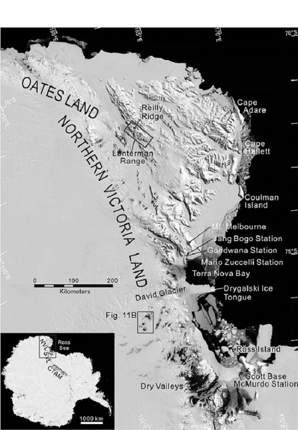
극지연구소 남극 대륙기지(장보고 과학기지)가 북빅토리아랜드(Northern Victoria Land) 테라노바만(Terra Nova Bay) 해안의 뫼비우스곶(Cape Möbius; 그림 1)에 건설된다. 북빅토리아랜드는 남극종단산맥(Transantarctic Mountains, TAM)의 태평양쪽 끝이며 남극대륙에서 가장 넓게 암석이 노출되어 있어 지질학적 연구를 수행하기 좋은 조건을 가지고 있다. 또한 기지 북쪽에 위치하는 멜버른산(Mt. Melbourne)은 로스해(Ross Sea) 형성에 관계된 열개작용에 의한 화산활동을 지시하는 등 다양한 지질학적 연구의 재료가 펼쳐져 있다. 이를 기반으로 극지연구소를 중심으로 한 우리나라의 지질학 연구가 활발히 펼쳐질 수 있을 것으로 기대된다.
남극대륙의 전기고생대 이후 지사는 남극종단산맥을 따라 노출된 암석들에 잘 기록되어있다. 남극종단산맥에는 캠브리아기에서 쥐라기에 이르는 퇴적체와 화산암체가 곤드와나(Gondwana)대륙의 형성 및 분리와 이에 수반된 지체구조 운동과 관련된 분지에서 형성되었고, 이와 연관된 화성암 관입체도 함께 발달하였다. 남극종단산맥은 중부남극종단산맥(Central Transantarctic Mountains, CTAM), 남빅토리아랜드, 그리고 북빅토리아랜드로 나누어지는데(그림 1), 이들은 큰 틀에서는 동일한 거시 규모의 지질운동을 경험했다. 하지만, 이중 북빅토리아랜드는 남극종단산맥의 다른 부분과는 다른 특이한 지질 역사를 가지고 있다.
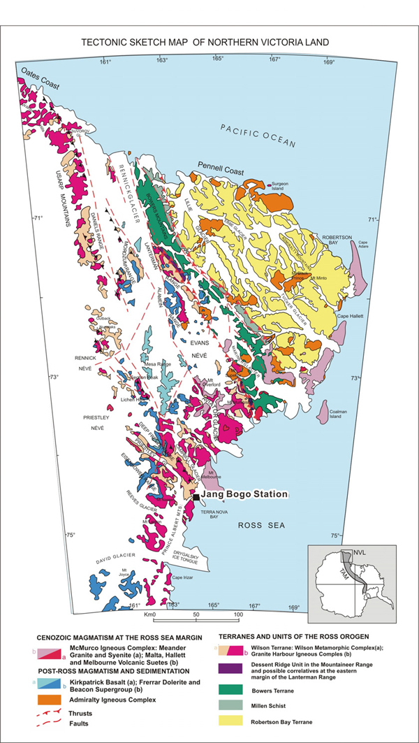
북빅토리아랜드는 1841년 로스(James Clark Ross)에 의해 발견된 후, 20세기 초 스콧(Robert Falcon Scott), 모슨(Douglas Mawson) 등의 탐사에 의해, 암석, 화석, 지자기자료들이 수집되었다. 이후 1950-60년대에 미국과 뉴질랜드 지질학자들에 의해 조사되어, 위성사진을 이용한 대략의 지형도와 지질도가 출판되었다. 이후 독일은 지질탐사 목적의 하계기지인 곤드와나 기지를 지었고, 이탈리아는 1986년에 하계기지인 마리오 주껠리(Mario Zucchelli) 기지를 지어 활발한 지질 탐사를 수행하였다. 특히 독일은 1979년부터 가노벡스(GANOVEX: German Antarctic Northern Victoria Land Expedition)라는 탐사 프로그램을 운영하여 북빅토리아랜드에 대한 지질-지구물리 자료를 획득해왔다. 이후 이탈리아, 독일, 미국은 GIGAMAP (German Italian Geological Antarctic Map Program)이라는 지질도 편찬 프로그램을 진행하여 현재 북빅토리아랜드 전체 면적의 절반 정도에 대한 1:250,000 지질도를 완성하였다(그림 2).
이와 같은 조사를 통해 북빅토리아랜드의 전반적인 암석의 분포와 대략의 지체구조적 역사는 밝혀졌지만, 접근이 어렵고 눈과 얼음으로 피복된 지형이 대부분인 남극이라는 특수성 때문에, 암석들 사이의 자세한 층서적 관계와 지질역사는 아직도 규명되지 않은 부분이 많다. 특히 첨단 분석장비들을 이용한 암석의 연대규명, 기원지분석, 지체구조적 환경 해석에는 더 많은 노력이 필요한 시점이다. 이에 이 논문에서는 남극종단산맥과 북빅토리아랜드의 지질을 개괄하며 이들이 어떠한 지체구조적 특징을 가지고 있는지에 대해서 간단히 고찰할 것이다. 특히 장보고 과학기지와 가까우며 복잡한 지질구조와 발달 역사를 가지고 있는 북빅토리아랜드의 층서와 분지진화를 자세히 다룰 것이다. 또한 우리나라 남극대륙 지질연구에 대한 중장기 계획에 대해 간략하게 논의한다.
2. 남극종단산맥의 지체구조적 진화
남극 종단산맥과 빅토리아랜드의 층서는 기본적으로 선캠브리아기 고도 변성암과 캠브리아기에서 오르도비스기에 이르는 하부고생대 저도 변성암, 데본기에서 삼첩기에 이르는 퇴적암, 그리고 쥐라기 화산암으로 대별된다(그림 3). 이들 사이의 경계를 이루는 부정합들의 시기와 특성은 대개 비슷하게 보이지만 지역적인 차이가 있으며, 그 사이에 발달한 퇴적층 또한, 지역에 따라 세부적인 암상과 퇴적상이 다르다

Very simplified, general stratigraphy of the Central Transantarctic Mountains (CTAM) and the Northern Victoria Land (NVL).
남극종단산맥과 빅토리아랜드의 지체구조 진화단계는 세 단계로 구분된다. 첫 번째는 신원생대에서 전기 고생대에 이르는 로스조산운동(Ross Orogeny)으로 곤드와나 초대륙의 고태평양 경계부를 따라 판이 섭입하고 몇 개의 지체구조적 터레인(terrane)이 부가되면서 퇴적체를 비롯한 기존의 암체들을 변성시키고 조산운동과 함께 쌓인 퇴적물의 특성 발달에 큰 영향을 미쳤다. 이 시기 중부남극종단산맥에서 가장 오래된 퇴적암은 선캠브리아기 님로드층군(Nimrod Group)의 상위에 위치하는 비어드모어층군(Beardmore Group)으로 연대는 대략 신원생대에서 캠브리아기 최하부에 이르는 것으로 생각된다(Laird et al., 1971; Borg et al., 1990; 그림 4). 이 층군은 변성된 규산염암과 탄산염암으로 이루어진 코브햄층(Cobham Formation)과 더 젊고 덜 변성된 사암위주의 골디층(Goldie Formation)으로 구성된다. 상위에 오는 버드층군(Byrd Group)은 최하부 고생대로 생각되며 아래에 위치한 비어드모어층군 위에 부정합적으로 놓이는 것으로 생각된다(Laird et al., 1971; Stump, 1995). 탄산염 대지 퇴적체(Rees et al., 1989)인 셰클턴석회암(Shackleton Limestone)이 버드층군의 가장 오래된 층이며 삼엽충과 고배류(archaeocyatha) 동물군에 의해 하부 캠브리아기로 연대가 정해졌다(Debrenne and Kruse, 1986; Palmer and Rowell, 1995). 스타샷층(Starshot Formation), 더글라스층(Douglas Formation), 딕층(Dick Formation) 등 몇 개의 쇄설성 규산염 퇴적암 층들이 셰클턴석회암 위에 놓이지만 이들의 층서적 관계는 제한된 노두와 화석을 비롯한 연대 자료의 부재로 잘 이해되지 않고 있었다. 하지만 최근 많은 야외조사 자료, 퇴적학 및 고생물학적 연구, 그리고 쇄설성 저어콘 연대 측정에 의해 이해의 폭이 넓어졌다(Goodge et al., 2002; Myrow et al., 2002).
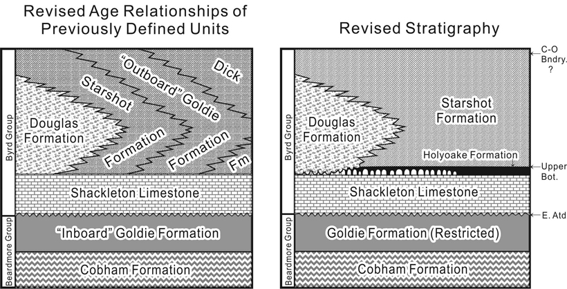
Lower Paleozoic stratigraphy of the Central Transantarctic Mountains influenced by the Ross Orogeny. Realistic and simpler stratigraphy had suggested based on detailed geologic mapping and detrital zircon age dating (Myrow et al., 2002). C-O=Cambrian-Ordovician, Bndry.=Boundary, Bot.=Botoman, Atd.=Atdabanian.
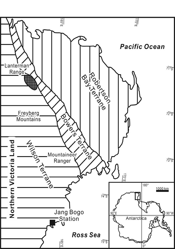
로스조산운동이 일어난 전기고생대의 북빅토리아랜드를 이루고 있는 지괴는 세 개의 부가(accretionary) 터레인인 윌슨 터레인(Wilson Terrane), 바워스 터레인(Bowers Terrane), 로버트슨 베이 터레인(Robertson Bay Terrane)으로 구성되어있다(그림 5). 윌슨 터레인은 중-고도 변성작용을 받은 신원생대에서 전기 고생대 변성암들로 이루어져 있으며, 캠브리아기-오르도비스기 화강암 복합체인 그래닛하버 관입체(Granite Harbour Intrusives)가 관입하였다. 바워스 터레인은 전기 고생대 쇄설성-화산암 복합체로 매우 약한 변성정도를 보인다. 전기고생대 로버트슨 베이 터레인은 단조로운 심해저 쇄설성 퇴적체로 이루어져 있으며 데본기에서-석탄기에 해당하는 화강암질 암석인 어드미럴티 관입체(Admiralty Intrusives)가 관입하고 있다.
로스조산운동에 뒤이은 두 번째 단계는 지체구조적으로 조용한 시기였으며, 후기 고생대에서 쥐라기에 해당한다(Woolfe and Barret, 1995). 이 시기에 로스조산대는 넓은 범위에서 침식되어 비교적 평탄한 준평원의 기반암을 이루었다. 기반암 위에는 비콘누층군(Beacon Supergroup)이라고 불리는 규산염 쇄설성 퇴적체가 광범위하게 쌓였다(그림 6). 중부남극종단산맥과 남빅토리아랜드에서는 누층군의 최하부에 데본기의 테일러층군(Taylor Group)이 발달하지만 북빅토리아랜드에서는 같은 시대의 지층이 발견되지 않는다. 상부에 놓이는 빅토리아층군(Victoria Group)은 최하부에 석탄기말기의 빙하 퇴적체를 포함하며, 광범위하게 발달한 하성 퇴적체와 화산암 등으로 이루어져 있다. 이들은 페라르층군(Ferrar Group)이라는 중기 쥐라기 현무암질 암석에 덮이거나 교호한다. 페라르층군은 커크패트릭 현무암(Kirkpatrick Basalt)을 포함하는 용암류와 조립현무암 수평관입체(Ferrar Dolerite Sill), 화산쇄설성 퇴적물로 이루어져있으며, 뒤이은 곤드와나 초대륙 분리와 관련된 초기화산활동의 산물로 생각된다(Storey et al., 2001). 이 화산암-퇴적암 복합체는 노출된 퇴적층의 평탄한 최상부를 형성한다. 북빅토리아랜드의 빅토리아층군은 페름기 택로우나층(Takrouna Formation)과 후기 삼첩기-쥐라기 섹션피크층(Section Peak Formation)으로 구성되며(Collinson et al., 1986), 두 층은 모두 사질 망상하천 퇴적체로 윌슨 터레인의 심성암-변성암 위에 부정합적으로 놓인다. Schöner et al. (2007)의 최근 연구로 삼첩기 이후의 중생대층 층서가 재정립되었다.
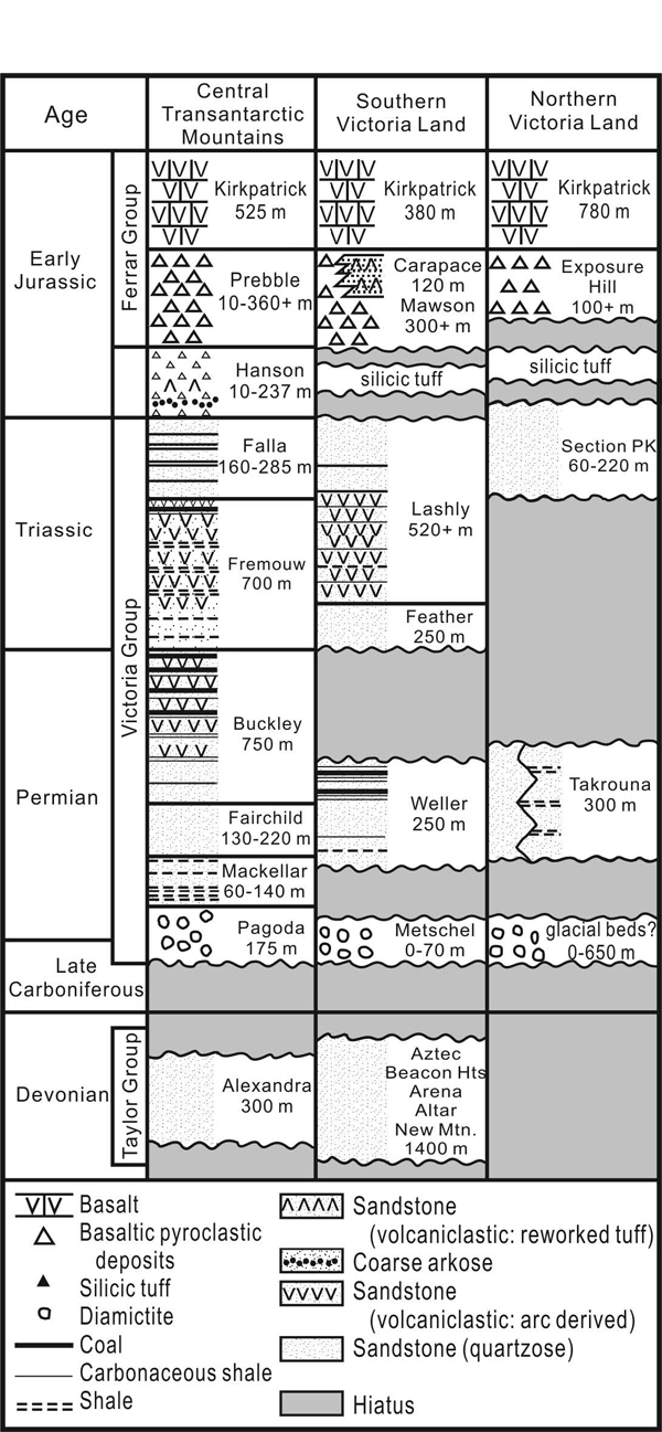
General stratigraphy of the Beacon Supergroup in the Central Transantarctic Mountains and the Victoria Land. Stratigraphic units are formations.
마지막 세 번째 단계는 쥐라기에서 제3기에 이르는 시기로 곤드와나 초대륙의 분리와 관련된 지각 확장이 일어난 때이며 남극대륙이 남아메리카, 아프리카, 인도, 오스트레일리아 등 곤드와나 초대륙의 다른 부분으로부터 분리되었다. 이때 형성된 남빙양(Southern Ocean)과 환남극한류(Circumpolar Current)로 인해 남극이 본격적으로 고립되고 추워지기 시작하였다. 또한 확장에 이어진 열곡의 발달로 인해 북빅토리아랜드에 접한 로스해(Ross Sea)가 만들어졌다(Woolfe and Barret, 1995).
3. 북빅토리아랜드의 전기 고생대 층서와 암상
로스조산운동에 영향을 받은 전기 고생대에 형성된 북빅토리아랜드는 윌슨 터레인, 바우어스 터레인, 로버트슨 베이 터레인의 세 지체구조 터레인으로 구성되어있다(그림 5; e.g. Tessensohn and Henjes- Kunst, 2005). 이들은 그 변성정도가 다를 뿐 아니라 구성하고 있는 원암인 퇴적암들의 특성도 달라 서로 다른 층서체계를 지니고 있다(그림 7).
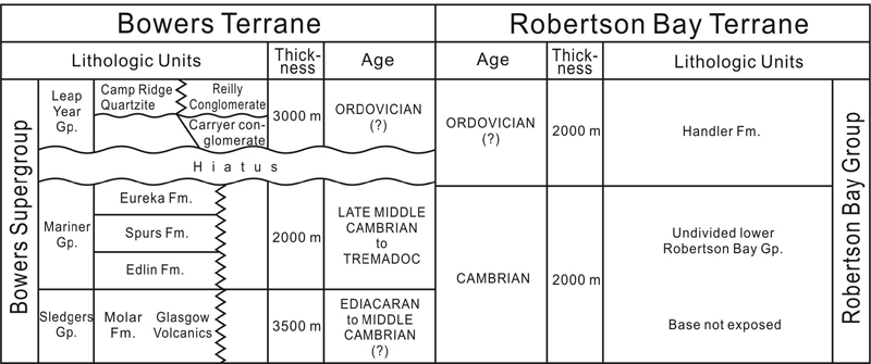
Lower Paleozoic stratigraphy of the Bowers and the Robertson Bay terranes (Casnedi and Di Giulio, 2003). The Wilson Terrane composed mostly of metamorphic and plutonic rocks is not considered in this table. Gp.=Group, Fm.=Formation.
3.1 윌슨 터레인
윌슨 터레인은 조산운동의 주향방향에 평행한 광역적인 변성대의 형태로 나타나는 변성퇴적암으로 이루어져 있으며, 서쪽에서 동쪽으로 갈수록 높은 변성도를 보인다(Ricci et al., 1997; 그림 2). 동쪽의 터레인 경계부근에서는 중간 정도의 온도 압력 변성 조건을 가지는 편마암 내에 유휘암(eclogite)을 포함한 염기성/초염기성 암체가 산출한다(Ricci et al., 1996; Capponi et al., 1997). 유휘암은 코에사이트(coesite)의 흔적을 포함하고 있어서 2.9 GPa에 이르는 압력을 받았음을 지시하며(Ghiribelli et al., 2002), 이는 500 Ma에 작용한 초고압 변성작용을 지시한다(Di Vincenzo et al., 1997). 란터만 레인지 지역(Lanterman Range; 그림 1, 2)에 뒤이어 나타나는 각섬암(amphibolite) 후퇴변성작용 (retrogression)은 약 490 에서 486 Ma사이에 일어났다(Goodge and Dallmeyer, 1996; Di Vincenzo and Palmeri, 2001). 이 연대 자료들은 유휘암과 뒤이은 각섬암 변성작용이 후기 캠브리아기에 해당한다는 것을 지시하며 이들이 로스조산운동과 관련있음을 보여준다. 캠브리아기-오르도비스기 칼크-알칼리 심성암체로 마그마 화산열도와 유사성을 가진 그래닛하버 관입체(540-535 Ma 에서 약 480 Ma 사이)가 윌슨 터레인을 관입한다(Stump, 1995).
3.2 바워스 터레인
바워스 터레인은 변성정도가 약하며, 하부로부터 슬레저스(Sledgers), 마리너(Mariner), 립 이어(Leap Year) 층군으로 이루어져있다(그림 7, 8). 슬레저스층군의 화산암들(Glasgow Volcanics)은 부수적으로 산성질(규장질) 화산암을 포함하는 현무암과 안산암으로 이루어져있다. 이들은 침상용암류(pillow lavas), 각력암의 구조로 산출되며 변성 퇴적암인 몰라층(Molar Formation)과 수지상으로 맞물려있어 해저에서 분출된 것임을 지시한다(Weaver et al., 1984). 이들의 지화학적 조성은 NMORB (normal mid-ocean ridge basalt), E-MORB (enriched MORB), T-MORB (transitional MORB), arc tholeiite, calc-alkaline, OIB (ocean island basalt) 마그마 등과 유사한 다양한 변화를 보인다(Rocchi et al., 2003). 몰라층은 세립사암과 셰일 위주로 이루어져있으며 왕모래(granule)를 포함하는 저탁암, 염기성/초염기성암과 규장질암의 역으로 구성된 역암을 드물게 포함한다(Wodzicki et al., 1982; Laird, 1987; Bassett et al., 2001; 그림 3). 이 층의 연대는 Guzhangian으로(late Middle Cambrian; Cooper et al., 1996), 그래닛하버 관입체의 연대와 겹친다. Laird (1987)은 이 층이 쌓인 분지가 북서-남동으로 연장된 해구였을 것으로 생각하였으며, 세립질 퇴적물은 분지의 심부를 나타내고, 조립질 퇴적물은 분지의 심부를 향해 발달한 사면을 절단하며 형성된 하도를 충진한 퇴적체로 해석하였다(그림 8).
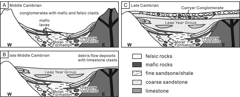
Schematic drawings showing the evolution of Lower Paleozoic sediments in the Bowers Terrane (Federico et al., 2009).
늦은 중기에서 이른 후기 캠브리아기 사이에 형성된 마리너층군의 퇴적양상은 점진적으로 충진되는 분지와 약해지는 화산활동을 나타낸다. 층군 전체에 잘 나타나는 해퇴의 경향은 조간대 퇴적층의 발달과 적색층(red bed)의 발달에서 극상을 이룬다(Andrews and Laird, 1976). 또한 캐리어 빙하(Carrier Glacier)지역에서는 두꺼운 비해성 혼성력 역암이 적색사암위에 놓이며 여기에 포함된 화강암 역의 연대는 그래닛 하버 화강암과 유사한 505 에서 508 Ma 사이로 나타났다(Bassett et al., 2001). 조립질 역암은 삼엽충 생층서에 의해 연대가 잘 정립된 란터만 레인지의 레일리 릿지 지역(Reilly Ridge; 그림 1, 2)의 마리너스 층군에서도 산출된다(Cooper et al., 1996; Weaver et al., 2003).
립이어층군은 육성 또는 해안 경계부에 해당하는 사암과 역암으로 이루어져 있다. 이들은 지역적으로 하부에 놓이는 마리너층군과 어긋나게 발달하는 경우도 있다. 화석이 산출되지 않는 이 층군의 퇴적시기는 하부에 놓인 상부 캠브리아기 퇴적체를 근거로 후기 캠브리아기 또는 전기 오르도비스기로 추정할 수 있다.
3.3 로버트슨 베이 터레인
로버트슨 베이 터레인은 습곡을 받은 저도변성 저탁암의 두꺼운 연속층으로 이루어져 있다(그림 2, 7). 저탁암은 육지의 변성암에서 기원한 것으로 여겨진다(Stump, 1995; Henjes-Kunst and Schüssler, 2003). 기저부는 노출되어 있지 않지만 최소 층후는 3,000 m로 제안된 바 있다. 퇴적시기는 잘 알려져 있지 않지만 터레인의 상부에 해당하는 핸들러층(Handler Formation)에 포함된 석회암에서 초기 오르도비스기(Tremadocian) 화석이 보고되었다(Burrett and Findlay, 1984; Wright et al.,1984). 하지만 핸들러층의 층서적 위치 또한 확실히 결정된 것은 아니다. 캠브리아기 이후의 연대는 저탁암의 쇄설성 저어콘 연대(495-500 Ma)에서도 나타나며(Fioretti et al., 2003), 쇄설성 운모의 연대는 485-490 Ma로 더 젊은 연대를 보인다(Henjes-Kunst, 2003). 하지만 기저부와 최상부가 정확히 구분되지 않았기 때문에, 이 터레인의 퇴적층을 그 특성이 비슷한 주변의 다른 퇴적층과 대비해 오르도비스기에서 데본기에 해당한다고 생각하기도 한다(Bradshaw et al., 2009). 터레인에 습곡을 형성한 변형시기 또한 불분명하다.
4. 북빅토리아랜드의 후기고생대-삼첩기 층서
데본기에서 삼첩기에 이르는 비콘누층군은 중부남극종단산맥과 빅토리아랜드에서 노출되며 로스 조산운동에 의해 형성된 광역적인 부정합인 쿠크리 침식면(Kukri Erosion Surface)을 경계로 하부의 데본기 이전 퇴적체들과 화성암-변성암 복합체 위에 놓인다(Stump, 1995; Isbell, 1999; 그림 6, 9). 가장 먼저 형성된 퇴적체는 석영 위주의 사암과 적은 양의 세립질층으로 이루어진 데본기의 테일러층군(Taylor Group)이다. 후에 형성된 두 번째 광역적 침식면 또는 부정합면인 마야 침식면(Maya Erosion Surface)위에는 석탄기-페름기-삼첩기의 빅토리아층군이 퇴적되었다(Isbell, 1999; 그림 6).
비콘누층군은 분출 화산암과 화산쇄설성 퇴적암으로 이루어진 페라르 화산암체에 의해 덮이며 동일한 기원의 마그마에서 비롯된 다수의 수평, 수직 암맥에 의해 관입되었다(그림 6). 데본기 테일러층군은 중부남극종단산맥과 남빅토리아랜드에만 나타나며 북빅토리아랜드에서는 발달하지 않는다. 반면 빅토리아층군은 남극종단산맥 전체에 걸쳐 나타나고, 퇴적 시작시기가 남에서 북으로 갈수록 늦어지며 같은 방향으로 전체 층의 두께는 얇아지는 경향을 보인다. 이 논문에서는 북빅토리아랜드에 발달하는 빅토리아층군만을 다룬다.
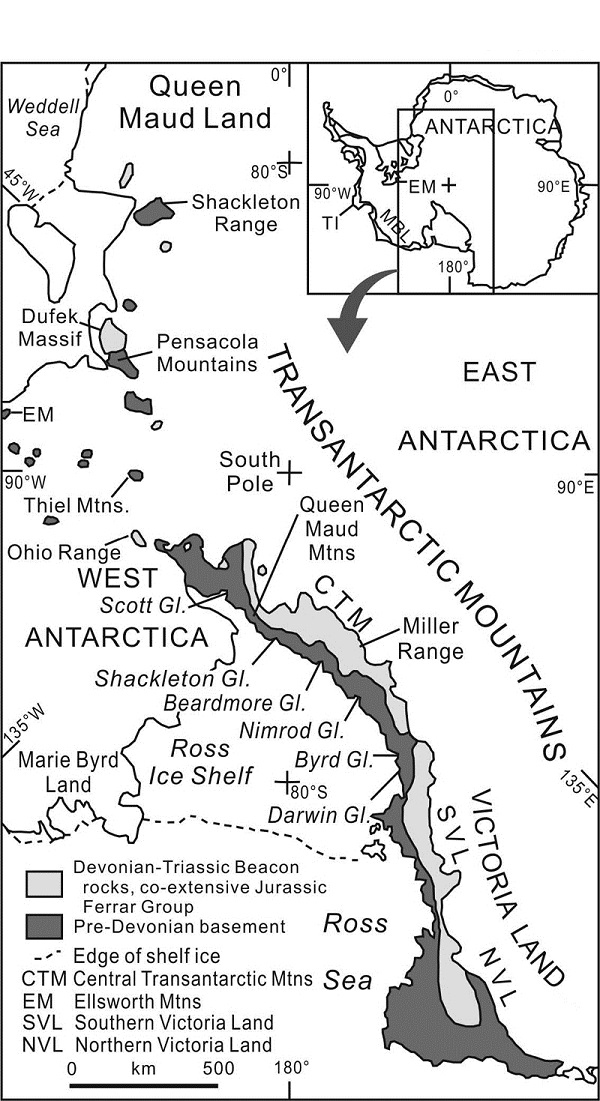
Geologic map showing distribution of the Devonian-Triassic Beacon Supergroup (Elliot and Fanning, 2008). EM: Ellsworth Mountains, MBL: Marie Byrd Land, TI: Thurston Island, Gl.=Glacier.
4.1 빅토리아층군
북빅토리아랜드 북부 알라메인 산맥(Alamein Range, 그림 2)의 비콘누층군 최하부에서 얇은(50-70 m) 후기 고생대 이질역암(diamictite)층이 발견되었다(Collinson and Kemp, 1983). 또한 북빅토리아랜드의 남쪽부분인 조이스 산(Mount Joyce, 그림 2) 지역에서도 이질역암층이 같은 층위에서 발견되었다. 이들은 모두 마야 침식면을 형성하며 퇴적된 후기 석탄기(?) 빙하퇴적층으로 생각되고 있다(Capponi et al., 1999b).
북빅토리아랜드의 페름기 지층인 택로우나(Takrouna)층은 알라메인 산맥과 모로주미 산맥(Morozumi Range)주변에 잘 나타난다(그림 2, 6). 약 300 m에 이르는 퇴적층은 대부분 사암, 탄질 실트암, 적은 양의 이암으로 이루어져 있으며, 기저부는 자갈과 왕자갈로 이루어진 역암이 특징적이다. 또한 얇은(0.5 m) 탄층이 다수 협재하기도 하고, 고토양층도 발견된다. 이 층은 망상하천에서 형성된 하성퇴적층으로 해석되었으며(John et al., 2011), 초기 하도는 복층구조(multi-story)를 이룬 형태가 많았으나, 점점 옆으로 단속적인 분포를 가진 형태로 변화해 가는 특성을 보인다. 북빅토리아랜드의 남쪽 부분인 마운트 조이스(Mount Joyce, 그림 2) 부근에서도 비콘누층군의 사암층에 페름기 Glossopteris 식물군이 산출되는 것이 보고되었으며, 이를 택로우나층으로 인지하였다.
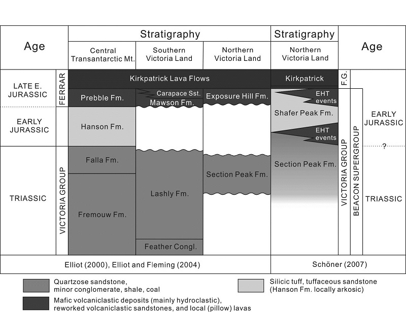
북빅토리아랜드 빅토리아층군 삼첩기의 퇴적체는 약 200 m 두께의 섹션피크층으로 곡사층리를 보이는 중립질-조립질 석영사암으로 이루어져있다. 이 층에서 발견되는 식물화석(Dicroidium)은 후기 삼첩기를 지시한다(그림 10). 섹션피크층은 전기 고생대 로스조산운동 시기의 변성암과 심성암을 자르는 침식면 위에 바로 놓이거나 택로우나층 위에 놓인다. 이전에 이름 붙여지지 않았던 약 50 m두께의 상부 층은 샤퍼피크층(Shafer Peak Formation)이라고 명명되었으며(Schöner et al., 2007), 연흔이 발달하는 세립질 응회암질 사암, 규산질 화산유리편으로 주로 이루어진 실트암으로 구성된다. 이 층은 Dicroidium 식물화석이 나타나지 않으며, 양치식물인 bennettitales, cycadophytes, dipterids 등이 산출되는 점을 근거로 퇴적시기는 전기 쥐라기로 추정되었다(Schöner et al., 2007).
수성분출(hydrovolcanic eruption)에 의한 것으로 해석되는 화산쇄설성 퇴적체가 섹션피크층과 샤퍼피크층에 협재하거나 또는 각 층을 절단하는 화도관(diatreme)으로 나타난다. 다른 이전의 모든 연구지역에서 이들을 층으로 구분해 단일한 동시대 지층(익스포져힐층: Exposure Hill Formation)으로 여겼던 것과 달리 이들은 다른 시대에 형성되었으며 하나의 암층서단위를 이루지도 않기 때문에 층으로 정의하는 것은 적절하지 않다(그림 10; Schöner et al., 2007). Schöner et al. (2007)은 이들을 Exposure Hill Type (EHT) “events”라고 정의하였다. 이와 유사한 성격과 시대의 화도관이 남빅토리아랜드와 중부남극종단산맥에서 보고된바 있다(Elliot and Hanson, 2001; White and McClintock, 2001; McClintock and White, 2006). 화도관의 충진체는 노출된 두께가 50-200 m 정도이며, 매우 무질서한 각력암 또는 화산괴(block)가 포함된 응회암을 하부에 가지며 재동된 화산쇄설성 사암으로 이루어진 세립질의 상부로 점진적으로 변화한다. 상부의 화산쇄설성 사암은 샤퍼피크층의 셰리빌 사암 또는 실트암과 교호하기도 한다. 이 퇴적층은 종종 횡적으로 제한된, 유기물이 많이 포함된 호성 셰일에 피복되기도 한다.
이 충진체는 주상절리가 잘 발달하는 평행 관입체 형태의 염기성 화성암체에 의해 절단되기도 한다(Elliot et al., 1986). 관입체의 두께는 약 100 m에 이르며 내부에 여러 단계의 관입에 의해 생성된 냉각 경계와 각력 구조와 평행한 다수의 절리면이 존재한다. 드물게 나타나는 소규모 관입은 폭이 수 미터에 지나지 않고 섹션 피크 층과 EHT 분출암체를 절단한다. 분출암 또는 화산쇄설성 퇴적층은 특징적으로 두께 10-20 m의 베개구조를 가지는 화산암체 또는 작은 화산암 복합체에 의해 피복된다. 이와 같은 소규모 용암류는, 지역적으로는 더 젊고 부피가 크며 고원을 이루는 커크패트릭 용암류로부터 얇은 화산쇄설성 퇴적체에 의해 분리되어 나타나는 경우가 있다.
비콘누층군내 사암의 기원지와 고수류방향 분석결과 페름기에는 퇴적물이 석영질 암석기원지로부터 산맥을 따라 남동쪽으로 공급되었음을 지시한다(Vavra et al., 1981; Isbell, 1991). 중기 및 후기 페름기 탄층이 퇴적되던 당시에는 서남극 주변에서 기원한 화산쇄설성 퇴적물이 분지로 공급되었지만 삼첩기로 접어들면서 화산쇄설성 퇴적물의 공급은 줄었으나, 퇴적물은 여전히 같은 방향에서 공급되었다. 화산재층과 화산유리편(shard)을 포함한 퇴적암은 중기 삼첩기에 퇴적과 동시에 발생한 화산활동이 있었음을 지시한다. 분지의 주요 배수계가 남서쪽으로 바뀌고 대륙전면부 분지가 남·북빅토리아랜드의 지각내 분지와 연결되는, 후기 삼첩기에 화산쇄설성 퇴적물의 공급이 다시 뚜렷해진다. 이때 고수류 방향은 호주를 향하고 있었다. 이런 주요한 주 배수계의 역전은 펜사콜라(Pensacola) 산맥과 엘스워스(Ellsworth) 산맥에서 나타나는 습곡-충상단층대 발달에서 기인한 것으로 생각된다(Collinson et al., 1994).
4.2 페라르층군
지체구조적으로 안정된 퇴적분지에서의 비콘누층군 퇴적작용은 전기 쥐라기에 이르러 중단되었으며, 뒤이어 곤드와나 대륙 활성경계부의 후열도 지역의 신장에 수반된 열개작용과 관련된 규산질 화산쇄설성 퇴적층인 샤퍼피크층이 형성되었다(Elliot, 1996, 2000). 전기 쥐라기 말기에는 페라르 쏠레아이트질(tholeiitic) 마그마가 분출되어 화산쇄설성 퇴적암과 용암류를 형성하였고 조립현무암의 수평·수직 관입체를 만들었다(Elliot and Fleming, 2008).
페라르층군의 커크패트릭 현무암류는 중부 북빅토리아랜드의 메사 산맥(Mesa Range), 남부 북빅토리아랜드의 마운트 조이스 등지에 넓게 나타나며 두께는 1000 m 이상에 이른다(Elliot et al., 1986; Roland and Wörner, 1996). 현무암류는 1 m에서 230 m에 이르는 다양한 두께의 화산암류층(flow unit)으로 나누어진다. 각 화산암류층은 특징적인 절리와 깨짐 형태, 침상구조, 수성각력암(hyaloclastite) 등을 나타내며 층 사이에 화산쇄설성 퇴적체 또는 얇은 호성퇴적체 등을 종종 포함한다(Elliot and Fleming, 2008).
5. 우리나라 남극대륙 지질연구
2014년 남극 장보고 과학기지의 완공과 운영에 앞서 극지연구소는 장보고기지 주변 지역에 대한 대한 기초 지질조사를 실시하며 본격적인 연구를 준비하고 있다. 2012년 1월과 2월에는 남극대륙 북빅토리아랜드 마운트 조이스 지역에서 운석연구진과 함께 지질조사를 수행하였다. 이 조사에서 데이비드 빙하(David Glacier)의 기반암의 암상과 분포양상을 조사했다(그림 11). 데이비드 빙하의 남서쪽 상류에 해당하는 조사지역의 주된 암석은 쥐라기 커크패트릭 화산암체와 여기에 관입한 페라르 조립현무암이며, 부분적으로 비콘누층군의 사암이 산출하기도 한다. 커크패트릭 화산암체에서 침상 현무암과, 두꺼운 현무암질 용암류 등을 관찰하였고, 또한 화산암체 사이의 퇴적층에서는 응회암, 화산력(lapilli) 응회암, 재동된 화산퇴적물, 그리고 이들을 절단하며 발달하는 두꺼운 수성각력암 등을 관찰하고 기재했다(그림 12). 현재 진행중인 과제에서는 데이비드 빙하의 기반암의 특성을 규명하기 위해 다양한 종류의 기반암에 대한 연구가 계획되어있으며, 2012-13년도 하계탐사에서는 하부 고생대 퇴적층과 그 기반암에 대한 탐사를 계획하고 있다. 이를 바탕으로 북빅토리아랜드의 지각형성에 지대한 영향을 끼친 지체구조적 운동인 로스조산운동과 곤드와나대륙의 분리 등에 대한 다양한 연구로 확장시켜 나갈 것이다. 또한 장기적으로 조사지역도 북빅토리아랜드에서 점차 남극종단산맥으로 확장시켜 연구주제와 그 결과가 남극전체 지질연구에 미치는 영향력을 키워나갈 계획이다
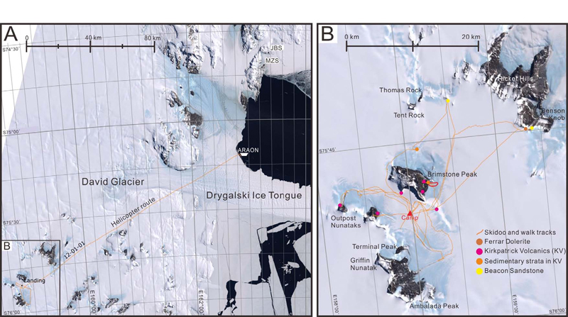
LANDSAT image maps showing camp and field work locations of the 2011-12 austral summer field season. (A) Map showing a helicopter route from the Ice Breaking Research Vessel, ARAON to the camp site. JBS=Jang Bogo Station, MZS=Mario Zucchelli Station. (B) Detailed satellite image of the studied area, with brief lithology of the outcrops.
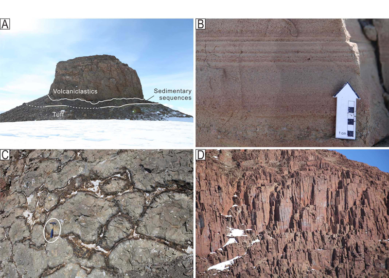
Geological features of the Mesozoic succession of the Northern Victoria Land. (A) A small nunatak showing a volcaniclastics cutting the underlying sedimentary strata. (B) Laminated sandstone which occurs between volcanic successions. (C) Pillow basalt in the lower part of the exposure of the Kirkpatrick Volcanics, showing well developed quenched margin. A hammer for scale (circled) is 27 cm long. (D) A cliff of dolerite sill in the Outpost Nunataks. Note well developed columnar joints. The height of the cliff in the view of the photograph is about 40 m.
6. 요약 및 결론
중부남극종단산맥의 전기고생대 퇴적암은 로스 조산운동과 관련된 비어드모어 층군과, 버드층군으로 대표되며, 주로 천해에서 형성된 사암, 이암 등 쇄설성 규산염 퇴적암과 소량의 탄산염암으로 이루어져있다. 로스조산운동 이후의 부정합을 경계로 상위에 놓이는 후기고생대층인 비콘누층군은 천해, 망상하천, 화산쇄설성 퇴적물로 이루어져 있으며 내부에 몇 개의 부정합면을 가지고 있다. 이에 비해 북빅토리아랜드의 전기 고생대는 윌슨, 바워스, 로버트슨 베이의 세 지체구조적 터레인이 부가, 접합되어있다. 윌슨 터레인에는 변성암과 화강암질 암석이 주로 나타나며, 바워스 터레인은 쇄설성 규산염 퇴적암과 화산쇄설성 퇴적암의 복합체로 이루어진 저도변성 퇴적암들로 이루어져 있다. 가장 바깥쪽의 로버트슨 베이 터레인은 심해저 저탁암이 지배적이다. 이 지역에서 하부고생대 로스조산운동과 관련된 퇴적분지 충진물 위에 놓이는 퇴적층은 천해, 망상하천, 화산쇄설성 퇴적물로 이루어진 빅토리아층군이다. 이후에 남극종단산맥 전체에 걸쳐 형성된 지층은 화산암과 용암 복합체인 페라르층군의 발달이 특징적이다. 이들은 쏠레아이트질 화산암으로, 분출되어 두껍게 쌓이거나 평행 또는 수직 관입체의 모습을 띠고 있으며 곤드와나 대륙이 분리되기 시작되는 초기 열개와 관련되어 분출한 것으로 생각된다.
지구상에서 가장 긴 섭입관련 조산대 중의 하나인 남극종단산맥은 그 길이만큼이나 다양한 형태의 조산운동이 일어났으며 관련된 퇴적분지가 생겨나고 퇴적물이 충진되면서 조산운동의 양태와 시기를 기록하고 있다. 특히 장보고 과학기지가 위치할 북빅토리아랜드의 퇴적분지는 남극종단산맥에서 뉴질랜드를 거쳐 호주로 연결되는 로스-델라메리안(Ross-Delamerian) 조산대의 중간부분으로서 남극의 지질과 관련된 다른 대륙의 지질현상을 연결하는 고리와 같은 역할을 하기 때문에 중요하다. 앞으로 극지연구소에서는 북빅토리아랜드를 대상으로 하는 다양한 지질학적 또는 다학제적 연구를 통해 남극대륙의 형성과 분리의 역사를 밝히고 주변 대륙과의 연결점을 찾는 것에 집중하려고 하며, 이에 국내 지질학계의 많은 관심을 기대한다.
Acknowledgments
논문을 심사해주시고 많은 건설적 제언을 해주신 이현석 박사와 한분의 익명 심사자께 감사드린다. 그림과 표 작업에는 극지연구소 김지훈 석사와 박명수 군에게 도움을 받았으며, 또한 지질도를 제공해준 독일 BGR의 Andreas Läufer에게 특별히 감사드린다. 본 연구는 극지연구소의 지원을 받았다(과제번호 PE13050).
References
-
P.B. Andrews,, M.G Laird,, Sedimentology of Late Cambrian regressive sequences (Bowers Group), northern Victoria Land, Antarctica, Sedimentary Geology, (1976), 16, p21-44.
[https://doi.org/10.1016/0037-0738(76)90011-7]

- K.N. Bassett,, S. Weaver,, J.D. Bradshaw,, T Ireland,, Conglomerate Provenance and Geochronology: Dating the Accretion of an Intra-Oceanic Arc, Bowers Terrane, Antarctica, Eos (Transactions, American Geophysical Union), (2001), 82(47), Abstract V41C-01.
-
S.G. Borg,, D.J. De Paolo,, B.M Smith,, Isotopic structure and tectonics of the central Transantarctic Mountains: Journal of Geophysical Research, (1990), 95, p6647-6669.
[https://doi.org/10.1029/JB095iB05p06647]

-
J.D. Bradshaw,, M. Gutjahr,, S.D. Weaver,, K.N Bassett,, Cambrian intra-oceanic arc accretion to the Austral Gondwana margin: constraints on the location of proto-New Zealand, Australian Journal of Earth Sciences, (2009), 56, p587-594.
[https://doi.org/10.1080/08120090902806339]

- M.A Bradshaw,, The Devonian Pacific margin of Antarctica. In: Thomson, M.R.A., Crame, J.A., and Thomson, J.W. (Eds.), Geological evolution of Antarctica, Cambridge University Press, Cambridge, (1991), p193-197.
-
C.F. Burrett,, R.H Findlay,, Cambrian and Ordovician conodonts from the Robertson Bay Group, Antarctica, and their tectonic significance, Nature, (307), p723-726.
[https://doi.org/10.1038/307723a0]

- G. Capponi,, D. Castelli,, A.M. Fioretti,, G Oggiano,, Geological mapping and field relationships of eclogites from the Lanterman Range (northern Victoria Land, Antarctica). In: Ricci, C.A. (Ed.), The Antarctic Region: Geological Evolution and Processes, Terra Antarctica Publication, Siena, (1997), p219-225.
-
G. Capponi,, L. Crispini,, M Meccheri,, Structural history and tectonic evolution of the boundary between the Wilson and Bowers Terranes, Lanterman Range, northern Victoria Land, Antarctica, Tectonophysics, (199a), 312, p249-266.
[https://doi.org/10.1016/S0040-1951(99)00174-2]

- G. Capponi,, L. Crispini,, M. Meccheri,, G. Musumeci,, P.C Pertusati,, Mount Joyce Quadrangle (Victoria Land), Antarctic Geological 1:250,000 Map Series, (1999b.).
- R. Casnedi,, A Di Giulio,, Sandstone petrography of the Bowers Supergroup and Robertson Bay Group (Mariner Glacier Area, Antarctica): preliminary report and remarks on the paleotectonic aspects of a suture zone, the Mariner Glacier Area Antarctica, German-Italian collaborative research in Antarctica, (2003), 85, p193.
- J.W. Collinson,, N.R Kemp,, Permian-Triassic sedimentary sequence in northern Victoria Land. In: Oliver, R.L., James, P.R., Jago, J.B. (Eds.), Antarctic Earth Sciences, Cambridge University Press, (1983), p221-225.
- J.W. Collinson,, D.H. Elliot,, J.L. Isbell,, J.M.G Miller,, Permian-Triassic Transantarctic Basin. In: Veevers, J.J. and Powell, C. McA. (Eds.), Permian-Triassic Pangaean Basins and Foldbelts along the Panthalassan margin of Gondwanaland, Geological Society of America, Memoir 184, Boulder, Colorado, (1994), p173-222.
- J.W. Collinson,, D.C. Pennington,, N.R Kemp,, Stratigraphy and petrology of Permian and Triassic fluvial deposits in Northern Victoria Land, Antarctica, Antarctic Research, (1986), 46, p211-242.
-
R.A. Cooper,, J.B. Jago,, J.G Begg,, Cambrian trilobites from northern Victoria Land, Antarctica, and their stratigraphic implications, New Zealand Journal of Geology and Geophysics, (1996), 39, p363-387.
[https://doi.org/10.1080/00288306.1996.9514720]

-
F. Debrenne,, P.D Kruse,, Shackleton Limestone archaeocyaths, Alcheringa, (1986), 10, p235-278.
[https://doi.org/10.1080/03115518608619158]

-
G. Di Vincenzo,, R Palmeri,, An 40Ar-39Ar investigation of high-pressure metamorphism and the retrogressive history of mafic eclogites from the Lanterman Range (Antarctica): evidence against a simple temperature control on argon transport in amphibole, Contributions to Mineralogy and Petrology, (2001), 141, p15-35.
[https://doi.org/10.1007/s004100000226]

-
G. Di Vincenzo,, R. Palmieri,, F. Talarico,, P.A. Andriessen,, C.A Ricci,, Petrology and geochronology of eclogites from the Lanterman Range, Antarctica, Journal of Petrology, (1997), 38, p1391-1417.
[https://doi.org/10.1093/petroj/38.10.1391]

-
D.H Elliot,, The Hanson Formation: a new stratigraphical unit in the Transantarctic Mountains, Antarctica, Antarctic Science, (1996), 8, p389-394.
[https://doi.org/10.1017/S0954102096000569]

-
D.H Elliot,, Stratigraphy of Jurassic pyroclastic rocks in the Transantarctic Mountains, Journal of African Earth Sciences, (2000), 31, p77-89.
[https://doi.org/10.1016/S0899-5362(00)00074-9]

-
D.H. Elliot,, C.M Fanning,, Detrital zircons from upper Permian and lower Triassic Victoria Group sandstones, Shackleton Glacier region, Antarctica: Evidence for multiple sources along the Gondwana plate margin, Gondwana Research, (2008), 13, p259-274.
[https://doi.org/10.1016/j.gr.2007.05.003]

-
D.H. Elliot,, T.H Fleming,, Occurrence and dispersal of magmas in the Jurassic Ferrar Large Igneous Province, Antarctica, Gondwana Research, (2004), 7, p223-237.
[https://doi.org/10.1016/S1342-937X(05)70322-1]

-
D.H. Elliot,, T.H Fleming,, Physical volcanology and geological relationships of the Ferrar large Igneous Province, Antarctica, Journal of Volcanology and Geothermal Research, (2008), 172, p20-37.
[https://doi.org/10.1016/j.jvolgeores.2006.02.016]

-
D.H. Elliot,, R.E Hanson,, Origin of widespread, exceptionally thick basaltic phreatomagmatic tuff breccia in the Middle Jurassic Prebble and Mawson Formations, Antarctica, Journal of Volcanology and Geothermal Research, (2001), 111, p183-201.
[https://doi.org/10.1016/S0377-0273(01)00226-8]

- D.H. Elliot,, Haban,, M.A., M.A Siders,, The Exposure Hill Formation, Mesa Range. In: Stump E.(Ed.), Geological Investigations in Northern Victoria Land, AGU Antarctic Research Series, American Geophysical Union, (1986), 46, p267-278.
-
L. Federico,, L. Crispini,, G. Capponi,, J.D Bradshaw,, The Cambrian Ross Orogeny in northern Victoria Land (Antarctica) and New Zealand: A synthesis, Gondwana Research, (2008), 15, p188-196.
[https://doi.org/10.1016/j.gr.2008.10.004]

- A.M. Fioretti,, P. Black,, F. Henjes-Kunst,, D Visona,, Detrital zircon age patterns from a large gneissic xenolith from Cape Phillips granite and from Robertson Bay Group metasediments, northern Victoria Land, Antarctica, 9th International Symposium on Antarctic Earth Sciences (Abstract), Potsdam, Germany, September, (2003), p8-12.
-
B. Ghiribelli,, M.-L. Frezzotti,, R Palmeri,, Coesite in eclogites of the Lanterman Range (Antarctica): evidence from textural and Raman studies, European Journal of Mineralogy, (2002), 14, p355-360.
[https://doi.org/10.1127/0935-1221/2002/0014-0355]

-
J.W. Goodge,, R.D Dallmeyer,, Contrasting thermal evolution within the Ross Orogen, Antarctica: evidence from Mineral 40Ar/39Ar Ages, Journal of Geology, (1996), 104, p435-458.
[https://doi.org/10.1086/629838]

-
J.W. Goodge,, P.M. Myrow,, I.S. Williams,, S Bowring,, Age and provenance of the Beardmore Group, Antarctica: Constraints on Rodinia supercontinent breakup, Journal of Geology, (2002), 110(4), p393-406.
[https://doi.org/10.1086/340629]

- F Henjes-Kunst,, Single-crystal Ar-Ar laser dating of detrital micas from metasedimentary rocks of the Ross orogenic belt at the Pacific margin of the Transantarctic Mountains, Antarctica, 9th International Symposium on Antarctic Earth Sciences (Abstract), Potsdam, Germany, Sept, (2003), p8-12.
- F. Henjes-Kunst,, U Schussler,, Metasedimentary units of the Cambro-Ordovician Ross Orogen in northern Victoria Land and Oates Land: implications for their provenance and geotectonic setting from geochemical and Nd-Sr isotope data, Terra Antarctica, (2003), 10(3), p105-128.
- J.L Isbell,, Evidence for a low-gradient alluvial fan from the palaeo-Pacific margin in the upper Permian Buckley Formation, Beardmore Glacier area, Antarctica, In: Thomson, M.R.A., Crame, J.A., Thomson, J.W. (Eds.), Geological evolution of Antarctica. Cambridge University Press, Cambridge, (1991), p215-217.
-
J.L Isbell,, The Kukri Erosion Surface: a reassessment of its relationship to the rocks of the Beacon Supergroup in the central Transantarctic Mountains, Antarctica, Antarctic Science, (1999), 11, p228-238.
[https://doi.org/10.1017/S0954102099000292]

- N. John,, R. Schöner,, R Gaupp,, Sedimentary architecture and provenance of the Permian Beacon Supergroup of Northern Victoria Land, Antarctica: implications for the correlation of a fluvial system, 11th International Symposium on Antarctic Earth Sciences (Abstracts), Edinburgh, July 10-15, (2011), p301.
- M.G Laird,, Evolution of the Cambrian-Early Ordovician Bowers Basin, northern Victoria Land, and its relationships with the adjacent Wilson and Robertson Bay Terranes, Memorie della Società Geologica Italiana, (1987), 33, p25-34.
-
M.G. Laird,, G.D. Mansergh,, J.M.A Chappell,, Geology of the central Nimrod Glacier area, Antarctica, New Zealand Journal of Geology and Geophysics, (191), 14, p427-468.
[https://doi.org/10.1080/00288306.1971.10421939]

- A Läufer,, From the Ross Orogeny at Gondwana‘s palaeo-Pacific margin to the Antarctic continent, KOPRI-BGR workshop, Incheon, 3-5, Nov, (2010.).
-
M. McClintock,, J.D.L White,, Large phreatomagmatic vent complex at Coombs Hills, Antarctica: Wet, explosive initiation of flood basalt volcanism in the Ferrar-Karoo LIP, Bulletin of Volcanology, (2006), 68, p215-239.
[https://doi.org/10.1007/s00445-005-0001-1]

- P.M. Myrow,, M.C. P.M., J.W. Goodge,, W. Fischer,, A.R Palmer,, Depositional history of pre-Devonian strata and timing of Ross orogenic tectonism in the central Transantarctic Mountains, Antarctica GSA Bulletin, (2002), 114(9), p1070-1088.
- A.R. Palmer,, A.J Rowell,, Early Cambrian trilobites from the Shackleton Limestone of the central Transantarctic Mountains, Journal of Paleontology, 69, Part II, supplement to 6, (1995), p1-28.
-
M.N. Rees,, B.R. Pratt, , A.J Rowell,, Early Cambrian reefs, reef complexes, and associated lithofacies of the Shackleton Limestone, Transantarctic Mountains, Sedimentology, (1989), 36, p341-361.
[https://doi.org/10.1111/j.1365-3091.1989.tb00611.x]

- C.A. Ricci,, F. Talarico,, R Palmeri,, Tectonothermal evolution of the Antarctic paleopacific margin of Gondwana: a northern Victoria Land perspective, In: Ricci, C.A. (eds.), The Antarctic Region, Geological Evolution and Processes, Terra Antarctica Publication, Siena, (1997), p293-296.
-
C.A. Ricci,, F. Talarico,, R. Palmeri,, G. Di Vincenzo,, P.C Pertusati,, Eclogite at the Antarctic palaeo- Pacific active margin of Gondwana (Lanterman Range, northern Victoria Land, Antarctica), Antarctic Science, (1996), 8(3), p277-280.
[https://doi.org/10.1017/S0954102096000399]

- S. Rocchi,, G. Capponi,, L. Crispini,, G. Di Vincenzo,, C. Ghezzo,, M. Meccheri,, R Palmeri,, Mafic rocks at the Wilson-Bowers Terrane transition and within the Bowers Terrane: implications for a geodynamic model of the Ross Orogeny, Terra Antarctica Reports, (2003), 9, p145-148.
- N.W. Roland,, G Wörner,, Kirkpatrick flows and associated pyroclastics: new occurrences, definition, and aspects of a Jurassic Transantarctic rift, Geologisches Jahrbuch, (1996), B89, p97-121.
- R. Schöner,, L. Viereck-Goette,, J. Schneider,, B Bomfleur,, Triassic-Jurassic sediments and multiple volcanic events in North Victoria Land, Antarctica: A revised stratigraphic model. U.S, Geological Survey and the National Academies, USGS OF-2007-1047 Short Research Paper, (2007), p102.
- B.C. Storey,, P.T. Leat,, J.K Ferris,, The Location of mantle plume centres during the initial stages of Gondwana breakup. In: Ernst, R.E. and Buchan, K.L. (eds.), Mantle Plumes: The Identification through Time, Geological Society of America Special Paper, 352, Boulder, CO, (2001), p71-80.
- E Stump,, The Ross Orogen of the Transantarctic Mountains, Cambridge University Press, Cambridge, (1995), p284.
-
F. Tessensohn,, F Henjes-Kunst,, northern Victoria Land terranes, Antarctica: far-travelled or local products. In: Vaughan, A.P.M., Leat, P.T. and Pankhurst, R.J. (Eds.), Terrane Processes at the Margins of Gondwana, Geological Society, London, Special Publications, (2005), 246, p275-292.
[https://doi.org/10.1144/GSL.SP.2005.246.01.10]

- C.L. Vavra,, K.O. Stanley,, J.W Collinson,, Provenance and alteration of Triassic Fremouw Formation, central Transantarctic Mountains, In: Cresswell, M.M. and Vella, P. (Eds.), Gondwana Five. A.A. Balkema, Amsterdam, (1981), p149-153.
- S. Weaver,, K. Bassett,, J. Bradshaw,, T Ireland,, Accretion of the Cambrian Bowers Terrane arc to the Gondwana Margin, northern Victoria Land: evidence from conglomerate provenance, 9th International Symposium on Antarctic Earth Sciences (Abstract), Potsdam, Germany, September, (2003), p8-12.
-
S.D. Weaver,, J.D. Bradshaw,, M.G Laird,, Geochemistry of Cambrian volcanics of the Bowers Supergroup and implications for the Early Palaeozoic tectonic evolution of northern Victoria Land, Antarctica, Earth and Planetary Science Letters, (1984), 68, p128-140.
[https://doi.org/10.1016/0012-821X(84)90145-6]

-
J.D.L. White,, M.K McClintock,, Immense vent complex marks flood-basalt eruption in a wet, failed rift: Coombs Hills, Antarctica, Geology, (2001), 29, p935-938.
[https://doi.org/10.1130/0091-7613(2001)029<0935:IVCMFB>2.0.CO;2]

- A. Wodzicki,, J.D. Bradshaw,, M.G Laird,, Petrology of the Wilson and Robertson Bay Groups and Bowers Supergroup, northern Victoria Land, Antarctica, In: Craddock, C. (Eds.), Antarctic Geosciences. Univ. Wisconsin Press, Madison, (1982), p549-554.
- K.J. Woolfe,, P.J Barret,, Constraining the Devonian to Triassic evolution of the Ross Sea sector, Terra Antarctica, (1995), 2, p7-21.
-
T.O. Wright,, R.J. Ross,, J.E Repetski,, Newly discovered youngest Cambrian or oldest Ordovician fossils from the Robertson Bay Terrane (formerly Precambrian), northern Victoria Land, Antarctica, Geology, (1984), 12, p301-305.
[https://doi.org/10.1130/0091-7613(1984)12<301:NDYCOO>2.0.CO;2]

