Volcanism in Jeju Island
We propose new genetic model of the volcanism in Jeju Island on the basis of borehole logging and interpretation of stratigraphy from over 100 exploratory boreholes (drilled at < EL. 600 m since 2001), whole rock composition and whole rock 40Ar/39Ar age dating of volcanic rocks from both 686 recovered cores out of 78 boreholes and 74 outcrop sites. The result indicates that the activity of alkali basaltic lava effusion on land must have started about 1 Ma ago and continued until Holocene. The rocks have 45~65 wt% SiO2, and belong to alkali basalt-trachybasalt-basaltic trachyandesite-trachyandesite-trachyte series, with transitional basalts, and tholeiitic basalts and andesites in composition. Especially, the rocks distributed at lowerland areas in the eastern and western regions are predominantly transitional basalts, and tholeiitic basalts and andesites in composition comparing with those in the northern and southern regions. By using Seoguipo Formation as index, the volcanism in Jeju Island is divided into syn-depositional (about 1.88~0.5 Ma) and post-depositional (0.5 Ma~Holocene) volcanic activities. The syn-depositioanal volcanic activities define activities of hydrovolcanisms with minor alkali basaltic lava effusions (about 1 Ma ago), domal extrusions with alkali evolved lavas and alkali lava effusions, which erupted locally and sporadically during the deposition of Seoguipo Formation. The post-depositional volcanic activities are defined as extensive volcanic activities on land after termination of sedimentation of Seogipo Formation since about 0.5 Ma. Especially, extensive volcanic eruptions during the period from 0.3 Ma to 0.1 Ma must have shaped the body of Jeju Island and volcanic eruptions from 0.1 Ma to Holocene must have constructed the present topography of Jeju Island with volcanic edifice, Hallasan Mountain (Mt. Halla). The study implies that Jeju Island has been generated by cumulating of outpoured lavas and volcanoclastics which were erupted from not only polygenetic composite volcano of Mt. Halla but also numerous monogenetic volcanoes, and which were intercalated with or underlain by Seoguipo Formation. Surface lava distribution map based on whole rock 40Ar/39Ar ages modified from geologic map of Park et al. (2008) is also proposed.
초록
이 연구는 2001년부터 제주도 해발 600 m 이하 지역에서 시행된 100여공의 시추공 지질 주상도 해석, 78개 시추공에서 획득된 686개의 시추 코어와 74개의 화산암류 노두 시료의 암석 성분 및 전암 40Ar/39Ar 연대 자료를 근거로 제주도의 화산활동사를 새롭게 제시하는데 목적이 있다. 그 결과 알칼리현무암질 용암이 약 1 Ma 전 최초 육상에서 분출하였으며, 화산활동은 홀로세까지도 진행되었음을 확인하였다. 용암류는 약 45~65 wt%의 SiO2 함량 범위를 가지며, 알칼리현무암-조면현무암-현무암질 조면안산암-조면안산암-조면암의 알칼리 계열의 암류와 이외에도 전이질 현무암과 비알칼리암류인 톨레이아이트질 현무암과 톨레이아이트질 안산암의 조성을 나타내었다. 특히 동서부 지역의 용암류는 남부 및 북부 지역에 비해, 전이질 현무암과 비알칼리암류가 상대적으로 더 많이 분포하고 있음이 확인되었다. 제주도의 화산활동은 서귀포층을 층준으로 크게 퇴적동시대 화산활동기(약 1.88~0.5 Ma)와 퇴적이후 화산활동기(0.5 Ma~홀로세)로 구분된다. 퇴적동시대 화산활동기는 약 1 Ma경 알칼리현무암질 용암의 육상 분출이 수반된 수성화산활동, 분화된 알칼리 계열 용암류의 돔상 분출, 알칼리 계열 용암류의 분출로 구분되는데, 이들은 서귀포층이 퇴적되는 동안 발생한 국지적이며 간헐적인 화산활동이었다. 퇴적이후 화산활동기는 서귀포층의 퇴적이 종료된 이후 전도에 걸친 활발한 육상화산활동으로 정의된다. 특히 약 0.3~0.1 Ma 동안의 활발한 화산활동은 제주도 지형의 골격을 형성하였고, 0.1 Ma이후 홀로세까지 이어진 화산활동은 한라산체를 포함한 제주도의 현재 지형을 만들었다. 이 연구는 제주도가 한라산체를 중심으로 하는 복성 복합화산체와 수많은 단성화산체로 부터 분출한 용암류 및 화산쇄설물이 층상으로 누적되어 형성된 것임을 의미한다. 이들은 수성화산분출물과 연안 퇴적물로 구성된 서귀포층에 협재하거나 피복한다. 전암 40Ar/39Ar 연대 자료를 이용하여 Park et al. (2008)의 지질도를 수정한 후 용암 분포도를 재구성하여 제시한다.
Keywords:
Jeju Island, new genetic model, volcanism, polygenetic composite volcano, monogenetic volcano, 40Ar/39Ar age, lava distribution map, 제주도, 새 형성 모델, 화산활동, 복성 복합화산체, 단성화산체, 40Ar/39Ar 연대, 용암 분포도1. 서 언
제주도는 비록 바다에 의해 둘러싸여 있지만 대륙붕 위에서 이루어진 대륙지각내 화산활동(continental intraplate volcanism)에 의해 만들어진 화산섬으로, 그 지질학적인 특징은 울릉도, 독도, 그리고 다른 해양 화산도(예, 하와이섬)와는 근본적인 차이를 지닌다.
제주도는 한반도에서 남쪽으로 약 90 km 떨어진 곳에 위치하며, 한라산(해발 1950 m)을 중심으로 남남서-북북동의 장축(약 70 km)과 약 30-35 km의 폭을 지닌 타원형의 본섬과 10여개의 부속 도서로 구성된다. 특히 제주도에는 368개(Jeju Special Self-Governing Province, 1997)에서 455개(Lee and Yun, 2012)에 이르는 “오름”이라 불리는 작은 화산체가 산재하는데, 이들 대부분은 분석구(scoria cone 혹은 cinder cone)이고, 응회환(tuff ring), 응회구(tuff cone), 마르(maar), 용암돔(lava dome), 소순상화산(small shield volcano)으로 구성된다(Lee and Yun, 2012). 이러한 소화산체는 주로 규모가 큰 순상화산 혹은 성층화산의 주화도(main conduit)의 측방 이동 혹은 열극을 따라 만들어진 화산이란 의미에서 기생화산(parasitic volcano)이라 흔히 불리었다. 그러나 최근의 연구는 이들이 순상화산과 성층화산의 사면 분화(flank eruption) 활동과 관계없이, 현무암질 화산지대에서 독립적인 화산체로서도 만들어 질 수 있으므로(예: Settle, 1979; Riedel et al., 2003), 각각 단일 화산활동에 의해 만들어진 화산체라는 의미에서 단성화산(monogenetic volcano)으로 정의한다(Cas and Wright, 1987; Valentine and Gregg, 2008; Németh, 2010; Fornaciai et al., 2012).
지금까지 제주도의 화산활동은 Haraguchi (1931)이후 여러 연구자들에 의해 단계별 모델이 제시되었으며(e.g., Won, 1976; Lee, 1982, 1994; Lee et al., 1994; Yoon et al., 1995; Son et al., 1998; Won et al., 1998; Oh et al., 2000; Kim et al., 2002; Yun, 2004), 최근까지 Lee (1982)의 네단계 형성 모델-(1) 기저현무암 분출기, (2) 용암대지 형성기, (3) 한라산체 형성기, (4) 기생화산 형성기-이 흔히 인용되고 있다(예: Kim and Choi, 2012). 또한 제주도 지질도폭 및 도폭설명서에서도 유사한 모델이 사용되었다(Won et al., 1993, 1995; Park et al., 1998, 2000a, 2000b, 2000c, 2008). 이들 전통적인 화산활동 모델은 첫째, 제주도 전체를 해양 화산도(특히 하와이섬)와 같은 하나의 순상화산체로 설정하고, 둘째, 시추공에서 얻어진 용암 시료를 통해 해석된 기저현무암을 제외하면 그 외의 화산활동으로 분출된 용암류는 대부분 지표에 노출되어 있는 것으로 전제하고 있다.
그러나 최근 제주도 섬 전체를 하나의 순상화산체로 해석하는 시각과는 달리 오름 하나 하나가 개별적인 단성화산체이며, 뉴질랜드의 오크랜드 등과 같이 제주도는 이들의 집합체인 현무암질 화산지대에 해당한다는 주장이 제기되었다(Brenna et al., 2010, 2011, 2012a, 2012b).
한편, 제주도 동부, 남서부 및 남부 지역의 시추공에서 얻어진 화산암류 시추코어의 암석화학 및 전암40Ar/39Ar 연대 자료를 토대로 한 연구에서 K-Ar 연대 자료를 바탕으로 설정된 기존의 제주도 화산활동 시기 구분이 전면적으로 수정되어야 할 것으로 제시되었다(Koh et al., 2008; Koh and Park, 2010a, 2010b).
따라서 제주도의 형성사 및 화산활동을 정의하는 것은 제주도 섬 전체를 순상화산의 형성 과정을 통해 이루어진 것 인지 아니면 소화산체의 집합인 화산지대로 볼 것 인가에서 시작된다고 하겠다. 이 연구는 시추공 지질검층 및 주상도 해석, 그리고 화산암류의 전암 암석성분 및 40Ar/39Ar 연대 자료를 근거로 제주도의 화산활동사를 새롭게 제시하는데 목적이 있다.
2. 연구 방법
2001년이래 제주특별자치도에서 추진된 해수침투 감시 심부 관측정 설치 사업을 포함한 지하수 개발 사업은 대부분 대구경(25~30 cm 지름)의 코어를 획득하는 시추 방식으로 진행되었다.
제주도 해발 600 m 이하에서 시행된 약 100여 시추공의 시추 코어에 대해 시추 지질도를 작성하고 인근 시추공간 지질 주상도를 해석하였다. 그 중 78개 시추공으로 부터 획득된 686개의 시추 코어 용암류 시료와 기존 발표된 K-Ar 연대 자료(Won et al., 1986, 1993; Yun et al., 1987; Tamanyu, 1990; Miyake et al., 1993; Lee et al., 1994; Kim et al., 2002; Koh et al., 2005a, 2005b)와의 비교를 위해 채취된 74개의 노두 시료에 대한 암석화학 성분 및 전암 40Ar/39Ar 연대를 측정하였다.
전암 주원소 및 미량원소의 화학분석은 미국 오레곤 주립대학교 불활성 기체 분석 실험실(http://geochronology.coas.oregonstate.edu/)에서 X선 형광분석법으로 이루어졌다. 전암 40Ar/39Ar 연대는 동일 실험실에서 MAP 215-50 모델의 불활성기체 질량분석기로 이루어졌으며, ArArCALC v2.2 전산프로그램(Koppers, 2002)으로 등시선 연대와 플래토 연대가 계산되었다. 특히 계산된 플래토 연대는 그 연대의 정확성을 논의하는데 중요한 기준인 MSWD (Mean Square of Weighted Deviates)의 값과 플래토의 형성 패턴 등에 근거하여 신뢰도가 크게 의문시되는 연대 자료를 배제하였다(McDougall and Harrison, 1988; Renne et al., 1998; Kelley, 2002; Koppers, 2002; Baski, 2006). 자세한 사항은 Koh et al. (2008)의 내용을 참조바라며, 이러한 기준에 따라 획득된 자료 중 15% 가량의 자료가 배제되었다. 개별 자료는 그 양이 방대하여 별도 서적으로 간행하려 준비 중이니 이해를 바란다.
78개 시추공 중 3개를 제외한 모든 시추공이 서귀포층을 포착하였으며, 그 중 48개의 시추공은 서귀포층을 관통하여 U층(Koh, 1997)에 도달한 후 시추가 종료되었다. 각 시추공에서 획득된 시추 코어에 대해 시추 지질도를 작성하였으며, 그 암석 분포 유형에 따라 제주도를 동서남북 네 구역으로 구분하였다. 연구에 사용된 시추공 및 노두 시료의 채취 위치는 표 1과 표 2, 그리고 그림 1에 나타내었다. 표 1에는 시추공의 경우 각 시추공에서 분석 시료 갯수, 전암 40Ar/39Ar 연대(최대 및 최소), 및 최상부 용암류의 성분을 함께 서술하였다.
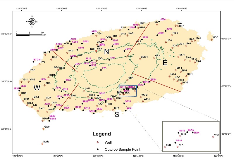
Map of borehole locations and outcrop sample sites in Jeju Island. Coordinate system is in ITRF2000, and contour lines are shown on 300 m, 600 m and 900 m high from the mean sea level (MSL). Four regions in Jeju Island are divided by red lines. Inset shows enlarged area for the location in the southern area.
한편, 시추공은 시추 종료 후 대부분 해수 침투 감시 관측정으로, 그리고 지하수 취수정(DUS, SAE, BHC, DNK, DH-S, DOS, HOG, KAJ, KEM, SAG, WAS, YCA), 해수 취수정(HAW, WOD, GAP, MAR), 인공함양정(BS-1, BS-2), 온천수 탐사정(CHY)으로 전환되었다.
3. 결 과
전암 40Ar/39Ar 연대는 단계별(평균 6 단계) 상승에 따른 스펙트럼으로부터 얻어진 각 시료별 플래토 연대를 나타내며, 95%의 신뢰수준을 지시하는 2σ(SD) 에러선을 같이 삽입하였고(그림 2), 암석의 명명은 전암 실리카 대 알칼리 함량 분류도(Le Bas et al., 1986)에 적용한 후 Park et al. (1999)에 따랐다(그림 3).
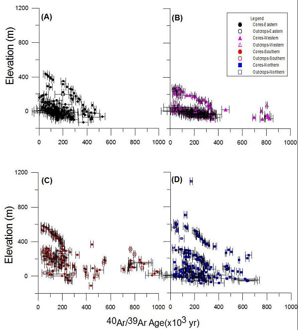
40Ar-39Ar age (with 2 SD) vs. elevation of the subsurface volcanic rock cores from boreholes (closed symbols) and outcrop samples (open symbols) in Jeju Island. (A) eastern area, (B) western area, (C) southern area, (D) northern area.
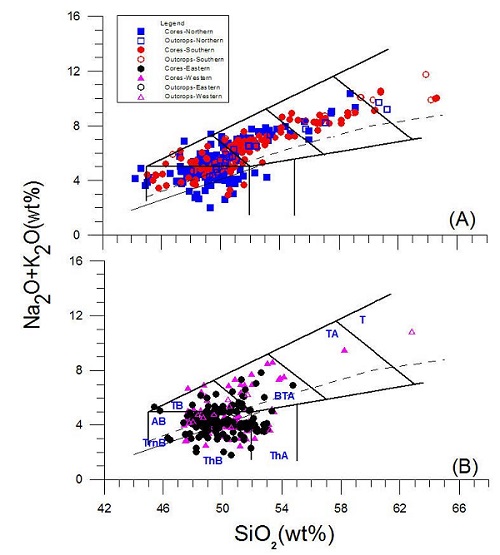
Na2O+K2O (wt%) vs. SiO2 (wt%) plot of the volcanic rock cores from boreholes and outcrop samples in Jeju Island. The fields show rock nomenclature schemes of Le Bas et al. (1986) with dashed line from Irvine and Baragar (1971) and thin solid line from Macdonald and Katsura (1964), dividing alkalic rocks from sub-alkalic rocks. A) northern and southern area, (B) eastern and western area. Abbreviation: ThA-tholeiitic andesite, ThB-tholeiitic basalt, TrnB-transitional basalt, AB-alkali basalt, TB-trachybasalt, BTA-basaltic trachyandesite, TA-trachyandesite, T-trachyte.
전암 40Ar/39Ar 연대 결과는 제주도가 지난 백만년간 지속적인 용암 분출(lava effusion)의 역사를 지니고 있음을 보여주며(그림 2), 이 기간 수많은 화산활동으로 분출한 용암류를 포함한 화산암류가 층상으로 축적되어 오늘날 제주도의 형태가 이루어졌음을 지시한다. 또한 제주도의 동부와 서부 지역은 남부(남서부 포함) 및 북부 지역에 비해 상대적으로 젊은 시기의 화산활동에 의해 형성되었음을 지시하며, 한라산을 중심으로 하는 중심 분출과 더불어 시기를 달리하는 소규모 단성화산체로부터 분출한 용암이 복잡하게 서로 중첩되어 있음을 시사한다.
단일 시추공내 혹은 인접 시추공간, 지역간 시추공내 용암류 전암 40Ar/39Ar 연대의 수직적인 변화는 심도가 깊어짐에 따라 용암류의 절대 연령이 점진적으로 증가하거나 혹은 급격하게 증가하는 현상을 나타내고 있다. 또한 화산활동의 시기 혹은 용암류의 분포 시기가 수직적으로 상이함은 물론 지역별로도 차이가 있음을 지시한다. 즉, 동일한 고도(표고)라고 할지라도 화산활동과 용암류의 분포 시기는 상당한 차이가 있다는 것을 의미한다. 이는 연대 자료를 포함하지 않고 암상에 근거한 시추공 주상도간의 층서 대비 및 해석시 상당한 오류를 야기할 수 있음을 지시한다. 오늘날 해안선 부근에 위치한 시추공에서 심도에 따른 용암류의 연대는 지역에 따라 서로 차이가 난다. 이는 제주도 형성 과정 동안 육상 지형과 접하는 고해안선이 상당히 불규칙한 모양을 하고 있었던 것을 유추할 수 있다. 또한 각 화산활동 시기에서 광역적으로 비슷한 수준의 고도를 이룬 것이 아니라, 용암류가 우세하게 흘러간 지역을 중심으로 서로 다른 고도차에 의한 굴곡 지형이 존재했던 것으로 해석된다.
한편, 위치적으로는 해수면 부근의 용암, 암석성분으로는 톨레이아이트질 성분의 용암, 그리고 시기적으로는 10만년보다 젊은 용암 시료가 다른 시료에 비해 상대적으로 연대 자료의 불확실성이 더 높음을 알 수 있다. 따라서 앞으로 이들 용암 시료에 대해 신뢰할 수 있는 전암 40Ar/39Ar 연대를 획득할 때는 상당한 주위가 필요함을 강조한다.
제주도를 구성하는 용암류는 45~65 wt%의 SiO2 함량 범위를 가지며, 알칼리현무암-조면현무암-현무암질 조면안산암-조면안산암-조면암의 알칼리 계열의 암류와 이외에도 전이질 현무암과 비알칼리암류인 톨레이아이트질 현무암과 톨레이아이트질 안산암으로 구성된다(그림 3). 이처럼 다양한 성분을 가진 용암류의 분포는 맨틀 근원지의 특징, 모마그마의 조성 그리고 마그마 분화 과정이 단순하지 않았음을 지시한다(Park and Kwon, 1996; Park et al., 1996; Chang et al., 1999; Tatsumi et al., 2005; Brenna et al., 2012b)
특히 동부와 서부 지역의 용암류는 남부 및 북부 지역에 비해 비교적 분화된 조면안산암과 조면암이 거의 분포하고 있지 않으며, 전이질 현무암과 비알칼리암류가 상대적으로 더 많이 분포하고 있음을 나타낸다. 이후 그림을 포함한 토의 부분에서 용암류는 화학 성분에 따라 세그룹, (1) 톨레이아이트질 현무암과 톨레이아이트질 안산암, (2) 현무암류, 전이질현무암-알칼리현무암-조면현무암, 그리고 (3) 안산암류, 현무암질 조면안산암-조면안산암-조면암으로 단순하게 구분하였다.
4. 토 의
이전 여러 연구자들에 의해 수행된 연구에서 제주도의 화산활동 및 층서를 논할 때, 표준 층서 지시자로서 “표선리현무암” 혹은 “서귀포층”이 흔히 사용되었다(e.g., Lee, 1982). 그러나 최근 연구에서는 제주도 동부와 서부 지역에서 비교적 평탄한 지형을 이루며 분포하는 표선리현무암이 10만년이내의 젊은 용암류에 해당함이 밝혀졌다(e.g., Koh et al., 2008). 이는 표선리현무암이 제주도 화산활동기 중 “용암대지 형성기”의 산물이라며, 화산활동 초기에 분출된 용암류로 규정해 온 이전의 층서 설정(예, Won, 1976; Lee, 1982)에 심각한 오류가 있음을 지시한다. 따라서 표선리현무암은 더 이상 제주도 화산층서 설정에서 층준으로 사용할 수 없다. 한편, 서귀포층은 제주도 서귀포시 천지연폭포 남서쪽 해안 절벽에 높이 약 30 m, 연장 약 1 km 규모로 분포하는 패류 화석대를 포함하는 퇴적층을 노두 표식지로 한다. Haraguchi (1931)에 의해 명명된 이래, 다양한 연구가 수행되었으며 최근까지 얻어진 시추 자료는 제주도 지하에 광범위하게 분포하고 있음이 알려졌다(Koh, 1997, Koh et al., 2004; Park et al., 2008). 이 층은 다양한 해양생물 화석과 흔적 화석을 포함할 뿐만 아니라, 수성화산활동에 의해 육지 또는 수중에 쌓인 일차 화산쇄설암과 육성 또는 해성 환경에서 재퇴적된 퇴적상, 그리고 비화산기원 퇴적상으로 구성된다(Koh, 1997; Sohn, 2004; Sohn and Park, 2004; Yoon and Chough, 2006; Sohn et al., 2008). 최근 연구는 U층 상부를 피복하여, 수증기성 폭발과 급냉으로 인한 마그마 기원 용암류의 파쇄작용으로 생긴 화도충진 화산쇄설암(diatreme)의 퇴적상을 가지고 있음도 보고되었다(Jeon et al., 2008; Jeon, 2009).
약 250여공의 시추 지질도를 이용하여 제주도 지하에서 서귀포층이 포착되는 등심도선을 ArcInfo 프로그램의 IDW(Inverse Distance Weight) 외삽법에 의해 작성하였으며, 시추 자료가 없는 지역은 빈 공간으로 남겨 두었다(그림 4A). 제시된 그림에서 보는 바와 같이, 해발 600 m 이하 지역에서 서귀포층의 포착 심도는 지역에 따라 뚜렷한 차이를 나타내고 있다. 즉, 남부 지역의 경우 안덕면 사계리~남원읍 위미리 사이 지역은 평균 해수면 상부에서 서귀포층이 포착되고 있으며, 특히 남부 서귀포 일대와 북부에서 한라산체와 가까워질수록 평균 해수면 위 100 m에서 서귀포층이 포착되고 있다. 반면, 동부 지역은 표선-조천으로 연결되는 해발 -60 m 등심선을 기준으로 동쪽을 향해 점진적으로 깊어져 신양리~행원리 사이 지역에서는 해발 -100 m이하에서 서귀포층이 포착되고 있다. 서부 지역에서 서귀포층은 대체로 해발 -50 m 내외에서 포착되고 있으나 무릉리와 영락리 일부 지역에서는 해발 -60 m이상을 나타내기도 한다. 따라서 그 분포는 해안가를 향해서는 오목하고 한라산체를 향해 볼록한 분포를 이룬다. 시추공에서 십여 m내지 수십 m의 다양한 층후를 가지는 서귀포층은 하부의 U층을 피복한다. U층은 미교결의 점토(뻘)와 모래로 구성되며, 제주도가 육지와 연결되었던 시기 해안가에 분포했던 퇴적층으로 황하강 혹은 양자강에 이어진 삼각주 형태로 분포했던 지층으로 추정된다(Park et al., 2008).
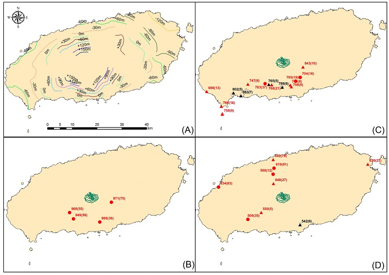
Locations of syn-depositional volcanic activities. (A) isopleths of top of Seoguipo Formation (numbers in elevation), (B) Lavas around 1 Ma, (C) Lavas between 900 ka and 650 ka (D) Lavas between 650 ka and 500 ka. Note most of lavas have distributed below the surface intercalated with Seoguipo Formation except for lavas in domal structures (black triangles) and Gapado. Contour lines depict in green for above 1500 m MSL. Symbol: circle; basaltic composition, triangle; andesitic composition, red; core samples, black; outcrop samples. Texts in red represent 40Ar-39Ar age with 2 SD.
서귀포층의 형성 시기는 고지자기 및 고생물학 연구를 통해 하부 경계는 최고 1.88 Ma (Kim and Lee, 2000)에서 1.66 Ma (Yi et al., 1998)로 부터, 노두 표식지에서 이 층을 피복하고 있는 용암류의 K-Ar 연대 자료에 의해 0.4 Ma의 상부 경계를 가지고 있음이 알려져 있으나(Lee et al., 1988), 동부 지역 시추공에서 획득된 결과는 0.3 Ma까지도 퇴적이 진행되었음을 지시한다(Koh et al., 2008). 지난 백만년 동안 빙하기/간빙기 동안 전세계 해수준면의 변화(Bintanja et al., 2005)와 제주도 주변의 해저 심도를 고려하면, 서귀포층이 퇴적되는 기간 동안 여러 차례의 해침과 해퇴에 의한 수심 및 퇴적 환경의 변화가 있었음을 알 수 있다. 따라서 서귀포층의 퇴적상과 형성 기간은 응회환 및 응회구를 형성시키는 수성화산활동과 연안 및 천해 환경에서의 퇴적작용이 오랜 기간에 걸쳐 제주도 형성 과정과 연관되어 지속되어 왔음을 지시한다(Sohn, 2004; Sohn and Park, 2004, Yoon and Chough, 2006; Sohn et al., 2008; Sohn and Yoon, 2010).
서귀포층은 수문지질학적 측면에서 지하수 부존 및 산출 특성을 규제하는 중요한 수문지질 단위가 되고 있다(Park et al., 2008). 이 연구에서는 제주도의 화산활동을 “서귀포층”을 층준으로 크게 퇴적동시대 화산활동기(stage of syn-depositional volcanic activities)와 퇴적이후 화산활동기(stage of post-depositional volcanic activities)로 구분하고, 각 화산활동기는 세부적인 특징에 따라 다시 세분하였다(표 3).
4.1 서귀포층 퇴적동시대 화산활동기(약 1.88~0.5 Ma)
이 시기는 서귀포층의 석회질 최미화석 연대와 연계한 고지자기 분석으로 얻어진 최고 연대(약 1.88 Ma; Kim and Lee, 2000)로부터 분출한 용암이 서귀포층에 협재하거나 지표에 돔상으로 산출하며, 최종적으로 서귀포층을 피복하기 이전까지의 화산활동기에 해당한다. 이때 서귀포층내에서 다양한 수성화산활동 및 해침과 해퇴에 의한 해수면 변동의 증거를 가지며, 육상으로 용암류의 분출은 매우 국지적이고 간헐적인 화산활동이 있었고, 그 전 후 다시 해침에 의해 해양성 퇴적층의 퇴적작용도 진행되었음을 암시한다.
이미 언급한 바와 같이 서귀포층내 수성화산활동에 대한 연대 자료가 드물 뿐만 아니라 보고된 자료도 신뢰하기 곤란하여 주변 육상 용암분출의 기록을 통한 그 화산활동의 시기와 유형을 구분하면 다음과 같다.
비록 서귀포층을 이루고 있는 화산쇄설암에 대한 수성화산활동의 시작 연대를 정확히 정의하기는 곤란하지만, 약 1 Ma전 최초 육상으로 현무암질 용암이 분출되었다. 이 시기 용암 분출의 기록은 남부 지역 4개의 시추공에서만 포착되는데(그림 4B), 주로 알칼리현무암질(알칼리현무암-조면현무암)의 성분을 지니며, 다공질이거나 각력으로 파쇄된 형태로 서귀포층에 협재하여 분포한다. 특히 하부에 분포하는 응회암류로 미루어 이전 수성화산활동 이후 육지화된 지역에서 분출한 것으로 해석된다. 05동홍(DOH)공에서는 992±21 Ka와 988±38 Ka의 연대를 지닌 두매의 조면현무암 성분의 용암류(각각 해발 50.6~44.6 m, 해발 64.6~52.6 m)가 가장 오래된 분출 연대를(Koh and Park, 2010b), 다음으로 신례(SHR)공에서 971±75 Ka (해발 135~120.5 m), 레이크힐스(LAH)공에서 968±55 Ka (해발 35~27 m), 광천수3호(HW-3)공에서 949±58 Ka (해발 40~-27 m)인 알칼리현무암 성분의 용암이 이에 해당한다. 이들의 산상으로 미루어 현무암질 용암은 수성화산활동 이후 육상 분화구로부터 소규모로 분출되었을 것으로 추정된다. 다만, 이들 시추공의 위치가 현재의 한라산체를 포함하여 타원형의 분포를 이루는 것으로 미루어 볼 때, 보다 고지대에서 심부 시추를 할 경우 더 많은 분포를 확인할 수 있을 것으로 여겨지며, 이들은 현재 한라산 백록담과 유사한 위치의 중심 분출지로 부터 분출되었을 가능성도 있다.
이 기간 용암 분출의 기록은 오늘날 지표에 돔상으로 노출되어있는 가파도(해식에 의해 평평한 대지를 이룸), 산방산, 월라봉, 각수바위, 원만사, 시오름(조면안산암, 0.700±0.021 Ma; Lee et al., 1994), 문섬(조면암, 0.728±0.034 Ma; Won et al., 1986), 섶섬(조면암, 0.725±0.038 Ma; Won et al., 1986), 범섬과 제주도 남서부 일대의 일부 시추공에서 그 분포가 확인된다(그림 4C). 이들의 성분은 주로 비교적 분화된 현무암질 조면안산암-조면안산암-조면암의 조성을 가진다.
월라봉(안덕면 대평리) 조면안산암(SE6)의 40Ar/ 39Ar 연대는 863±7 Ka, 산방산 조면암(SE04)은 802±5 Ka, 각수바위 조면암(SE10)은 799±6 Ka, 원만사 조면암(SE09)은 765±5 Ka이다. 산방산 조면암의 연대는 기존 보고된 K-Ar 연대 범위(870±130 Ka, Yun et al., 1987; 747±23 Ka, Won et al., 1986)에 속하지만, 각수바위 조면암은 기존 K-Ar 연대(917±28 Ka~ 893±27 Ka, Lee et al., 1994) 보다 젊은 연대를 제시한다.
서부 지역 무릉1호(MR-1)공에서 15 m 두께(해발 -61.8~-76.8 m)를 지닌 치밀질 조면안산암 성분의 용암류는 698±13 Ka로서, 이 시기 용암류로서는 가장 젊다. 하모(HMO)공에서 3.5 m 두께(해발 -84.9~-88.4 m)의 치밀질인 현무암질 조면안산암은 766±18 Ka로서, 인접한 가파(GAP)공에서는 표토를 제외한 시추공 전구간(해발 21.7~-70 m)에서 분포하는 현무암질 조면안산암의 연대가 824±32 Ka, 813±25 Ka, 808±21 Ka, 758±9 Ka로 상부로 감에 따라 젊어지는데(Koh and Park, 2010a), 이들의 분출과 유사한 시기에 분출되었을 것으로 해석된다. 상예(SAE)공에서는 서귀포층내 왕자갈 상태로 채취되었는데(해발 65~64.5 m), 조면암 성분으로 40Ar/39Ar 연대는 747±6 Ka이다. 이는 주변의 산방산 혹은 월라봉과 같은 돔상 조면암의 풍화물이 재퇴적된 것으로 해석된다. 도순(DOS)공에서는 60 m의 비교적 두꺼운 용암단위(해발 190 ~130 m)를 지닌, 치밀질 조면암으로, 하부는 774± 24 Ka, 상부는 768±21 Ka로서 상부로 감에 따라 젊어진다. 이 용암층은 인접 지역인 원만사 지역의 돔상 조면암과 같은 시기에 분출한 것으로 추정된다. 돈내코(DNK)공에서는 휘석-감람석 반정이 우세한 반상 조직을 가진 용암류가 비교적 두꺼운 용암단위(해발 180~52 m)로 분포하는데 알칼리현무암의 성분을 가지며, 40Ar/39Ar 연대는 795±19 Ka이다. 법호천(BHC)공에서 50 m (해발 120~70 m) 두께, 여러 매의 용암단위로 구성되고 비교적 치밀질이며 하부에서는 현무암질 조면안산암이나 상부에서는 조면현무암으로 그 조성이 염기성화되어짐을 보인다. 각각의 40Ar/39Ar 연대는 711±6 Ka와 704±16 Ka이다. 동홍-S(DH-S)공은 70 m의 비교적 두꺼운 용암단위(해발 181~111 m)를 지닌 치밀질 조면안산암으로, 40Ar/39Ar 연대는 763±8 Ka이다. 05동홍(DOH)은 28 m의 비교적 두꺼운 용암단위(해발 129.6~99.6 m)로 치밀질 조면안산암이 분포하는데, 이들의 40Ar/ 39Ar 연대는 758±8 Ka, 756±8 Ka으로 상부로 감에 따라 젊어지며, 이 용암층은 인접한 동홍-S(DH-S)공의 것과 같은 용암층이다. 이들의 분포가 주로 제주도의 장축 방향과 나란한 배열을 이루고 있는 것으로 미루어 이 기간 제주도의 장축 방향과 나란히 지각내에 형성된 비교적 연약한 틈새를 따라 마그마방에서 알칼리현무암질 마그마로부터 분화된 성분의 용암이 지표에 각각 독립적인 돔상의 화산체를 이루었을 것으로 해석된다.
한편, 가장 높은 고도이며 한라산에 근접한 신례(SHR)공에서는 알칼리현무암에서 현무암질 조면안산암의 성분을 지닌 여러 매의 치밀질 용암층이 연속적으로 산출하는데(해발 226.5~135 m), 40Ar/39Ar 연대는 880±39 Ka, 857±97 Ka, 852±89 Ka, 840±10 Ka이다. 이는 약한 열극을 따른 돔상 화산활동과 더불어 중심 분화구로부터 지속적으로 용암이 분출했을 것으로 추정된다.
이 시기의 분출 기록은 제주도 전역에 걸쳐 산발적이고 국지적인 분포를 통해 확인되는데, 그 성분은 알칼리현무암-조면현무암-현무암질 조면현무암-조면안산암-조면암의 성분 범위를 지닌 알칼리암류이며, 제주도 동부, 북부, 서부에 비해 남부 지역의 용암류 연대가 상대적으로 젊다(그림 4D).
서부 지역의 협재(HYJ)공에서는 1.5 m두께(해발 -73.7~-75.2 m)의 다공질 미반정 용암류는 조면현무암의 성분을 가지며, 40Ar/39Ar 연대는 634±63 Ka이다. 반면, 동부 종달1호(JD-1)공에서는 서귀포층내 자갈(해발 -137.8~-138.8 m)로서 산출하여 현무암질 조면안산암의 성분을 가지며, 40Ar/39Ar 연대는 639±27 Ka이다. 북부 지역의 경우 해안가에 근접한 용담1호(YD-1)공에서 약 24.5 m 두께(해발 -34.8 ~-59.3 m)의 치밀질 용암으로 하부에서 상부로 감에 따라 현무암질 조면안산암과 조면현무암의 성분으로 변화하는데, 이들 각각의 연대는 642±79 Ka, 628± 109 Ka이다. 용담2호(YD-2)공에서는 약 7 m두께(해발 -33.1~-40.1 m)의 치밀질 용암류는 알칼리현무암 성분을 지니며, 619±91 Ka과 535±26 Ka의 연대를 가진다. 노형(NOH)공에서는 조면현무암 성분의 다공질 용암류(해발 83.6~68.1 m)에서 558±10 Ka를, 거문(KEM)공에서는 조면현무암 성분의 치밀질 용암류(해발 51~37 m)에서 588±12 Ka의 연대를 갖는다. 어승생(ESG)공에서는 약 85 m 구간(해발 249.2~164.2 m)에서 수매의 용암류와 클링커층이 반복하여 분포하는데, 용암류는 조면안산암과 현무암질 조면안산암의 성분을 가지며 이들의 연대는 648±27 Ka, 637±14 Ka, 568±6 Ka로 상부로 갈수록 젊어진다. 남부 지역 상예(SAE)공에서는 2 m두께해발 73~71 m)의 다공질인 조면현무암의 성분을 가지는 용암류가 509±35 Ka이며, 레이크힐스(LAH)공에서 50 m두께(해발 216~166 m)인 조면암 성분의 용암류가 556±7 Ka, 550±5 Ka이다. 이 기간 지표에 노출된 용암돔은 신효동에 위치한 월라봉 조면암(SE20), 542±6 Ka이다.
4.2 서귀포층 퇴적이후 화산활동기(0.5 Ma~홀로세)
이 시기는 해퇴 등에 의해 제주도 지형이 육지로 노출되기 시작하여, 이후 활발히 재개된 화산활동으로 육상에서 분출한 용암이 서귀포층을 피복하고 현재의 제주도 지형을 이루는 시기에 해당한다. 비록 드물지만 해안가 시추공내에서 파쇄된 베개용암 각력이나 유리쇄설성 각력(hyaloclastite breccias)의 산출은 이 기간 제주도 주변 해수면의 변동이 여러번 있었다는 증거를 제시한다.
서귀포층의 노두 표식지에서 서귀포층을 피복하고 있는 직상부의 현무암질 조면안산암 조성의 용암은 K-Ar 연대 자료에 의해 0.41±0.01 Ma임이 알려져 있으나(Lee et al., 1988), 여래동(SE07) 및 강정동(SE23) 해안가에 분포하는 조면현무암과 현무암질 조면안산암 조성의 용암은 각각 485±19 Ka, 403±9 Ka이다. 이 기간 서귀포층을 직접 피복하는 용암류가 시추공에서 전 지역에 골고루 분포하는 것으로 미루어(그림 5A), 제주도 전역에 걸쳐 본격적인 육상화산활동이 활발이 진행되었음을 지시한다.
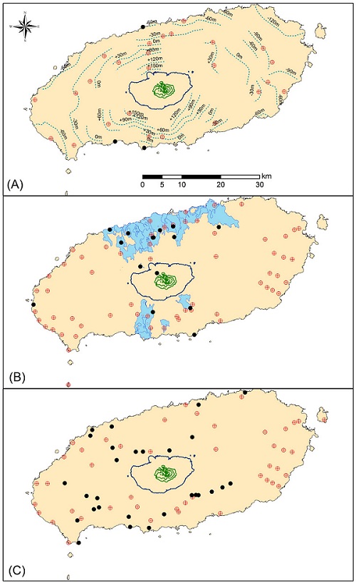
Locations of post-depositional volcanic activities. (A) Lavas between 500 ka and 300 ka with isopleths of Seoguipo Formation. The exposed lavas are distributed in limited areas along the southwestern coast and as dike in the northern area. (B) Lavas between 300 ka and 100 ka. The exposed lavas are mainly distributed in the northern and southern areas including Jejigi-oreum with Dangsanbong at the western area. (C) Lavas less than 100 ka. Contour lines depict in green for above 1500 m MSL and in blue for 600 m MSL. Symbol: red; boreholes, black; outcrop samples.
동부 지역에서는 한동1호(HD-1)공, 하천4호(HC-3)공, 종달4호(JD-4)공, 종달5호(JD-5)공, 삼달1호(SD-1)공, 삼달3호(SD-3)공, 수산4호(SS-4)공, 교래(GYR)공, 삼다수1호(SDS-1)공에서 기재되며, 최고 526±23 Ka (SD-3, 현무암질 조면안산암) 부터 최소 368.5± 37.9 Ka (HD-1, 톨레이아이트질 안산암)이다. 북부 지역에서는 어승생(ESG)공, 도남(DON)공, 함덕2호(HM-2)공, 이도(IDO)공, 장전(JAJ)공, 거문(KEM)공, 노형(NOH)공, 상가(SAG)공, 삼양1호(SY-1)공, 와산(WAS)공, 용담2호(YD-2)공에서 기재되며, 최고 516±15 Ka (KEM, 조면현무암) 부터 최소 327±14 Ka(DON, 조면현무암)이다. 서부 지역은 봉성1, 2호(BS-1, -2)공, 청수(CHS)공, 일과(ILK)공, 금악(KUM)공, 상모1호(SM-2)공, 용수1호(YS-1)공에서 기재되고, 최고 460±32 Ka (KUM, 조면현무암)부터 최소 333±17 Ka (CHS, 조면현무암)이다. 남부 지역은 호근(HOG)공, 강정(KAJ)공, 레이크힐스(LAH)공, 상예(SAE)공, 천지연(CHY)공, 신례(SHR)공, 위미(WMI)공, 위미2호(WE-2)공에서 관찰되며, 최고 488±6 Ka (WMI, 조면안산암) 부터 최소 325±15 Ka (SHR, 조면안산암)이다. 특히 서귀포층 노두 표식지와 인접한 천지연(CHY)공에서는 해발 -112 m 지점에서 U층을 관입한 산상으로 분포하는 현무암질 조면안산암 성분의 용암은 437±15 Ka이다. 한편, 제주시 인근 도두봉 서쪽(AE01)에서 응회구를 관입한 알칼리현무암 조성의 암맥은 410±51 Ka로서, 지금까지 자료로 미루어 도두봉은 육상에 노출된 가장 오래된 분석구라 할 수 있으며, 서부 당산봉 응회구와 함께 산출하는 알칼리현무암(JE23)은 327±11 Ka로서, 당산봉 응회구도 이 기간 수성화산활동에 의해 형성되었음을 짐작할 수 있다.
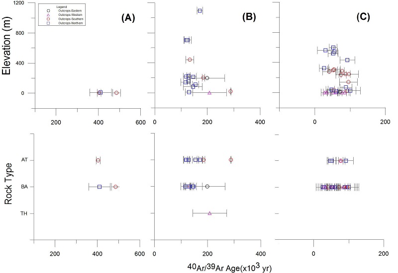
이 시기 동안 비록 지역적으로 화산활동 시기의 차이는 있으나 제주도 전 지역에 걸쳐 본격적인 육상화산활동에 의한 용암의 분출이 있었으며, 원시 제주도의 육지 형태를 형성하였을 것으로 추정된다. 그 용암류의 성분은 알칼리암류 이외에도 전이질 현무암과 특히 동부와 서부 지역에서 비알칼리암류인 톨레이아이트질 현무암과 안산암이 소규모로 분출이 되었다는 점이 주목된다(그림 6A, 7A).
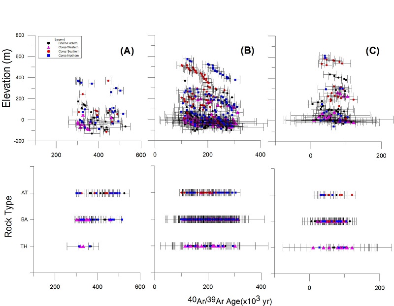
40Ar-39Ar age (with 2 SD) vs. elevation (m) and vs. rock types of the subsurface volcanic rock cores from boreholes (closed symbol) in Jeju Island. (A) Lavas between 500 ka and 300 ka, (B) Lavas between 300 ka and 100 ka, (C) Lavas less than 100 ka. AT-basaltic trachyandesite, trachyandesite and trachyte in composition, BA-trachybasalt, alkali basalt and transitional basalt in composition, TH-tholeiitic basalt and tholeiitic andesite in composition.
이 시기의 특징은 제주도 전체에서 광역적인 육상화산활동이 있었으며, 한라산체를 포함한 제주도의 주 모습이 형성되었고, 제주도 남부 지역을 제외한 동부, 북부, 서부 지역에서 지속적인 비알칼리암류의 분출이 활발히 일어났던 것이다(그림 5B, 그림 6B와 7B). 한라산 고지대 부분과 동서부 지역은 최근 10만년내에 분출된 용암류에 의해 대부분 피복되었으나, 제주 북부 저지대 및 서부 해안(당산봉 및 단산 일대)과 남부 일부 지역에서 이 시기의 용암류가 분포하고 있다. 북부와 남부 지역이 주로 알칼리암류가 노출된 것에 비해 서부 지역에서 고산-대정 등지에서 비알칼리암류가 분포하며, 서귀포 제지기오름(SE21)의 조면암 돔이 이 시기(288±1 Ka)에 형성하였다. 한편, 부속 도서로는 마라도가 톨레이아이트질 안산암류의 조성을 지닌 파호이호이 용암 분출에 의해 형성되었다(MAR; 259±168 Ka; Koh and Park, 2010a). 일반적으로 제주 북부 및 한라산 국립공원내에 분포하는 조면암류는 백록담 조면암의 K-Ar 연대(25±8 Ka, Won et al., 1986; 70±10 Ka, Tamanyu, 1990)에 해당하는 제주도 화산활동 중 최후기에 해당하는 용암류로 분류가 되었다. 그러나 이 연구에서 항파두리 조면암(AE03)과 어리목계곡(Y계곡)에 노출된 조면암(YVA)이 각각 128±4 Ka, 171±11 Ka의 연대를 지닌다. 해발 700 m 이상의 한라산 국립공원내에는 백록담 북-서-남벽을 포함한 골머리오름(해발 848.4 m)-아흔아홉골, 성널오름(해발 1215.2 m), 돌오름(해발 1278.5 m), 작은두레왓기암-큰드레왓(해발 1623.4 m), 영실(영실기암-병풍바위, 해발 1639.3 m), 왕관릉(해발 1666.3 m), 삼각봉(해발 1695.5 m), 윗세오름(해발 1749 m), 장구목오름(해발 1813 m), 산벌른내(해발 1000~900 m) 등지에 조면암이 분포한다(Environmental Resources Institute, 2009). 이들은 통상 “백록담조면암군(Chang et al., 2006)” 혹은 “한라산조면암(Park et al, 2000b; Koh et al., 2003; Yoon et al., 2005)”에 해당하는 것으로 분류되어 제주도 형성 최후기의 분출 산물로 해석되어졌으나, 앞으로 이들 조면암을 대상으로 정확한 연대 측정을 통해 화산활동시기를 밝혀야 하리라 여겨진다.
한편, 시추공에서는 용암층 사이에 고토양층이 1-3회 가량 협재하는데, 이 시기에도 국지적으로 간헐적인 화산활동의 휴지기가 있었음을 나타낸다.
이 시기의 화산활동은 현재 지표에 노출된 많은 오름(분석구, 응회구 및 응회환)을 분화구로 하는 화산활동이 있었으며(그림 5C, 6C, 7C), 백록담 및 그 동쪽 사면을 피복하는 조면현무암질 성분의 파호이호이 용암의 분출을 포함한 한라산체의 완전한 모습을 형성한 시기이다(Park et al., 2000b; Koh et al., 2003). 특히 동부와 서부의 저지대 지역은 활발한 톨레이아이트질 현무암 및 안산암 성분의 파호이호이형 분출로 비교적 평탄한 지형을 이루고 있어, 이미 언급한 바와 같이 이들은 초기 제주도 용암대지를 이루는 표선리현무암으로 해석되기도 하였다. 한편, 알칼리암류 성분의 아아형 용암의 분출은 제주도에 곶자왈이라는 독특한 지형 형태를 형성하였다. 식생의 보고인 곶자왈 지대는 최근 곶자왈 지질과 지하수 함양에 관한 연구가 진행되고 있다. 부속 도서로는 우도와 비양도가 이 시기에 형성되었다. 우도는 응회구와 용암 대지 그리고 분석구로 구성되는데(Koh et al., 2005a; Brenna et al., 2010), 분석구내서 시추된 시추공(WOD)으로 부터 지표에 노출된 톨레이아이트질 안산암 이전 최초 분출한 용암이 알칼리현무암임이 확인되는데, 그 연대는 86±10 Ka이다. 한편 분석구와 용암 대지로 구성된 비양도에서 조면현무암 성분의 용암(BYD-5)은 27±9 Ka로, 이는 제주도 용암류의 연대 중 가장 젊은 용암 그룹에 해당한다. 섬의 지질학적 특징은 우도와 달리 비양도가 육상화산활동에 의해 만들어졌음을 지시한다(Koh et al., 2008; Brenna et al., 2010).
지금까지 자료를 검토한 결과, 제주도 화산암류의 전암 40Ar/39Ar 연대 측정법으로는 약 2만년에서 최근까지의 화산활동을 정확히 정의하기 곤란하다. 화산퇴적물의 광여기 루미네선스 연대 측정과 방사성 탄소 연대 측정에 따르면 일출봉, 수월봉, 송악산의 수성화산활동이 지난 2만년내에 있었음을 보고하고 있다(Sohn et al., 2002; Jeong et al., 2007; Kim et al., 2010). 또한, 역사 기록은 고려시대(동국여지승람; 1002년, 1007년)와 조선시대(이조열성실록; 1455년, 1570년)에도 화산폭발 및 지진으로 인한 피해를 기록하고 있어, 제주도에서 화산활동이 극히 최근까지 있었음을 짐작하게 한다(Won, 1976).
5. 결 론
2001년대 이후 코어 획득 방식으로 제주도내에서 시추된 약 100여 시추공의 시추 지질도 작성 및 주상도 해석과 그 중 78개 시추공에서 선택된 686개의 시추 코어와 74개의 노두 시료의 암석성분 및 전암 40Ar/39Ar 연대 자료에 근거하여 제주도의 화산활동사를 새롭게 해석하였다. 제주도의 용암 분출을 통한 화산활동은 서귀포층을 층준으로 크게 퇴적동시기(약 1.88~0.5 Ma)와 퇴적이후 화산활동기(0.5 Ma~홀로세)로 구분된다. 즉 약 0.5 Ma를 전후로 하여 그 전의 수성화산활동과 산발적인 육상화산활동 시기와 그 후 전면적인 육상화산활동 시기로 정의할 수 있다. 특히 약 1 Ma경 현무암질 용암의 최초 육상 분출이 있었고, 약 0.3 Ma의 이후 홀로세까지 이어진 전도에 걸친 활발한 육상화산활동은 한라산체를 포함한 제주도의 현재 지형을 만들었다.
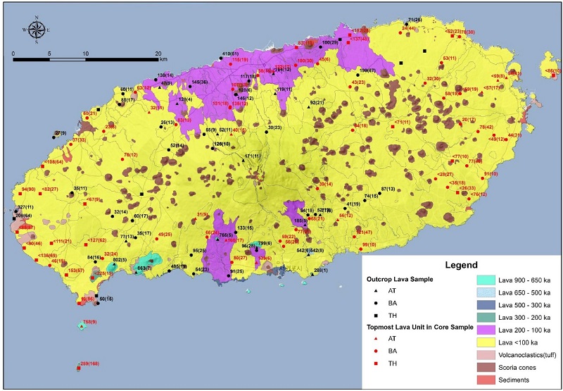
화산체 형태의 성인과 관련하여 엄밀한 의미(USGS, 2008)에서 제주도는 한라산체를 중심으로 하는 복성(polygenetic) 복합화산체(composite volcano)와 수많은 오름(지하에 매몰된것 포함)으로 대변되는 단성(드물게 복성)화산체로 부터 분출한 용암류 및 화산쇄설물이 퍼즐 조각과 같이 합쳐지고 층상으로 누적되어 형성된 것이라고 정의할 수 있다. 또한 이를 구성하는 용암류는 대부분 육상화산활동에 의해 분출된 것이며, 이들은 수성화산분출물과 연안 퇴적물로 구성된 서귀포층에 협재하거나 피복한다. 이 연구의 결과는 복합화산체론(Yoon et al., 2009) 및 현무암질 화산지대론(Brenna et al., 2012b)과 부분적으로 부합하며, 지금까지 제주도를 하와이섬과 같은 해양화산도의 형성 과정과 같이 하나의 순상화산체로서 해석하는 전통적 사고에서 탈피해야 할 것이다.
Park et al. (2008)은 지표에 노출된 용암류를 41개의 용암층으로 구분한 바 있는데, 이 연구에서는 용암류의 암석성분과 전암 40Ar/39Ar 연대를 토대로하여 화산활동 기간별로 용암 분포도를 재구성하여 제시한다(그림 8). 앞으로 한라산국립공원내 분포하는 용암류 및 이 연구에서 자료의 신뢰도로 인해 사용하지 못한 많은 용암류에 대한 추가적인 연대 자료의 보완으로 좀 더 정밀한 용암 분포도가 될 것을 기대해 본다. 더불어 한라산 백록담과 근접한 고지대에서의 심부 시추는 한라산체를 형성한 화산활동을 규명하는데 가장 중요한 자료를 제공할 것으로 사료된다.
Acknowledgments
논문의 심사과정에서 건설적인 비평과 유익한 조언을 해 주신 부경대학교 박계헌 교수와 익명의 심사위원님께 감사드린다.
References
- A.K Basksi,, Guidelines for assessing the reliability of 40Ar/39 Ar plateau ages: application to ages relevant to hotspot tracks, http://www.mantleplumes.org/ArAr.html, (2006.).
-
R. Bintanja,, R.S.W. van de Wal,, J Oerlemans,, Modelled atmospheric temperatures and global sea levels over the past million years, Nature, (2005), 437, p125-128.
[https://doi.org/10.1038/nature03975]

-
M. Brenna,, S.J. Cronin,, I.E.M. Smith,, Y.K. Sohn,, K Németh,, Mechanisms driving polymagmatic activity at a monogenetic volcano, Udo, Jeju Island, South Korea, Contributions to Mineralogy and Petrology, (2010), 160, p931-950.
[https://doi.org/10.1007/s00410-010-0515-1]

-
M. Brenna,, S.J. Cronin,, K. Németh,, I.E.M. Smith,, Y.K Sohn,, The influence of magma plumbing complexity on monogenetic eruptions, Jeju Island, Korea, Terra Nova, (2011), 23, p70-75.
[https://doi.org/10.1111/j.1365-3121.2010.00985.x]

-
M. Brenna,, S.J. Cronin,, I.E.M. Smith,, R. Maas,, Y.K Sohn,, How small-volume basaltic magmatic systems develop: a case study from the Jeju Island Volcanic Field, Korea, Journal of Petrology, (2012a), 53, p985-1018.
[https://doi.org/10.1093/petrology/egs007]

-
M. Brenna,, S.J. Cronin,, I.E.M. Smith,, Y.K. Sohn,, R Maas,, Spatio-temporal evolution of a dispersed magmatic system and its implications for volcano growth, Jeju Island Volcanic Field, Korea, Lithos, (2012b), 148, p337-352.
[https://doi.org/10.1016/j.lithos.2012.06.021]

-
R.A.F. Cas,, J.V Wright,, Volcanic Successions, Allen and Unwin, London, (1987), p528.
[https://doi.org/10.1007/978-94-009-3167-1]

- K.H. Chang,, J.B. Park,, S.T Kwon,, Petrography and mineral chemistry of trachytes in Cheju Volcanic Island, Korea, Journal of the Geological Society of Korea, (1999), 35, p15-34, (in Korean with English abstract).
- K.H. Chang,, J.B. Park,, S.T Kwon,, Geochemical characteristics of trachytes in Jeju Island, Journal of the Geological Society of Korea, (2006), 42, p235-252, (in Korean with English abstract).
- Environmental Resources Institute, The natural resources in Mt.Hallasan. Jeju Special Self-Governing Province, Jeju, (2009), p347, (in Korean).
-
A. Fornaciai,, M. Favalli,, D. Karaton,, S. Tarquini,, E Boschi,, Morphometry of scoria cones, and their relation to geodynamic setting: A DEM-based analysis, Journal of Volcanology and Geothermal Research, (2012), p217-218-56-72.
[https://doi.org/10.1016/j.jvolgeores.2011.12.012]

- K Haraguchi,, Geology of Saishu (Jeju) Island, Bulletin of Geological Survey of Korea, (1931), 10, p1-34, (in Japanese).
-
T.N. Irvine,, W.R.A Baragar,, A guide to the chemical classification of the common volcanic rocks, Canadian Journal of Earth Sciences, (1971), 8, p523-548.
[https://doi.org/10.1139/e71-055]

- Jeju Special Self-Governing Province, Oreum in Jeju Island. Jeju, (1997), p483, (in Korean).
- Y.M Jeon,, Lithofacies and emplacement processes of the volcanogenic rocks in the Cretaceous Gyeongsang Basin and Quaternary Jeju Island, Korea, (unpublished Ph.D. thesis), Gyeongsang National University, Jinju, (2009), p165.
- Y.M. Jeon,, K.H. Park,, Y.K Sohn,, Characteristics of diatreme deposits in the subsurface of Jeju Island, Korea, The 6th International symposium of Jeju Volcanological Institute (Abstracts), Jeju, (2008), p105-117.
-
G.Y. Jeong,, C.S. Cheong,, J.H Choi,, The effect of weathering on optically stimulated luminescene dating, Quternary Geochronology, (2007), 2, p117-122.
[https://doi.org/10.1016/j.quageo.2006.05.023]

-
S Kelly,, Excess argon in K-Ar and Ar-Ar geochronology, Chemical Geology, (2002), 188, p1-22.
[https://doi.org/10.1016/S0009-2541(02)00064-5]

-
C.B. Kim,, J.Y. Kim,, K.S. Kim,, H.S Lim,, New age constraints for hominid footprints found on Jeju Island, South Korea, Journal of Archaeological Science, (2010), 37, p3338-3343.
[https://doi.org/10.1016/j.jas.2010.08.002]

- I.S. Kim,, D Lee,, Magnetostratigraphy and AMS of the Seoguipo Formation and Seoguipo Trachyte of Jeju Island, Korea, Journal of the Geological Society of Korea, (2000), 36, p163-180, (in Korean with English abstract).
-
K.H. Kim,, T. Tanaka,, K. Suzuki,, K. Nagao,, E.J Park,, Evidence of the presence of old continental basement in Cheju volcanic island, South Korea, revealed by radiometric ages and Nd-Sr isotopes of granitic rocks, Geochemical Journal, (2002), 36, p421-441.
[https://doi.org/10.2343/geochemj.36.421]

- Y.S. Kim,, S.H Choi,, Plagioclase-rich nodules in Taeheungri basalt from Namwon, Jeju Island and its implications for tholeiitic magmatism, Journal of the Geological Society of Korea, (2012), 48, p313-324, (in Korean with English abstract).
- G.W Koh,, Characteristics of the groundwater and hydrogeologic implications of the Seoguipo Formation in Cheju Island, (unpublished Ph.D. thesis), Pusan National University, Pusan, (1997), p326, (in Korean with English abstract).
- G.W. Koh,, J.-B Park,, The Study on Geology and Volcanism in Jeju Island (II): Petrochemistry and 40Ar/39Ar Absolute ages of the Volcanic Rocks in Gapado-Marado, Jeju Island, Economic and Environmental Geology, (2010a), 43, p53-66, (in Korean with English abstract).
- G.W. Koh,, J.B Park,, The study on geology and volcanism in Jeju Island (III): early lava effusion rocords in Jeju Island on the basis of 40Ar/39Ar absolute ages of lava samples, Economic and Environmental Geology, (2010b), 43, p163-176, (in Korean with English abstract).
- G.W. Koh,, J.B. Park,, Y.S Park,, The study on geology and volcanism in Jeju Island (I): Petrochemistry and 40Ar/39Ar absolute ages of the subsurface volcanic rock cores from boreholes in the eastern lowland of Jeju Island, Economic and Environmental Geology, (2008), 41, p93-113, (in Korean with English abstract).
- G.W. Koh,, K.H. Park,, J.B. Park,, W.B Park,, Interpretation on volcanic activities in Biyangdo, western Jeju Island, Annual conference of the Geological Society of Korea (Abstracts), Jeju, (2008), p27-28, (in Korean, title translated).
- G.W. Koh,, Y.S. Park,, W.B Park,, Subsurface stratigraphy and 40Ar-39Ar absolute age in the eastern area of Jeju Island, Volcanic rocks and Volcanic activities in Jeju Island. Field Trip Guide, Spring Excursion of the Geological Society of Korea, Jeju, (2004), p29-50, (in Korean, title translated).
- J.-S. Koh,, S.-H. Yun,, H.-C Hong,, Morphology and petrology of Jisagae columnar joint on the Daepodong basalt in Jeju Island, Korea, Journal of Petrological Society of Korea, (2005a), 14, p212-225, (in Korean with English abstract).
- J.-S. Koh,, S.-H. Yun,, G.B. Hyeon,, M.W. Lee,, Y.-W Gil,, Petrology of the basalt in the Udo monogenetic volcano, Jeju Island, Journal of Petrological Society of Korea, (2005b), 14, p45-60, (in Korean with English abstract).
- J.S. Koh,, S.H. Yun,, S.S Kang,, Petrology of the volcanic rocks in the Paekrogdam crater area, Mt. Halla, Jeju Island, Journal of Petrological Society of Korea, (2003), 12, p1-15, (in Korean with English abstract).
-
A.A Koppers,, ArArCALC software for 40Ar-39Ar calculations, Computers & Geosciences, (2002), 28, p605-619.
[https://doi.org/10.1016/S0098-3004(01)00095-4]

- M.J. Le Bas,, R.W. Le Maitre,, A. Streckeisen,, B Zanettin,, A chemical classification of volcanic rocks based on the total alkali-silica diagram, Journal of Petrology, (1986), 27, p745-750.
- D.Y. Lee,, S.K. Yun,, J.Y Kim,, Y.J Kim,, Quaternary geology of the Jeju Island, Korea Institute Energy & Resources Rpt 87-29, (1988), p233-278, (in Korean).
- J.H. Lee,, S.H Yun,, Morphological analysis of Quternary monogenetic volcanoes in Jeju island, Journal of the Geological Society of Korea, (2012), 48, p383-400, (in Korean with English abstract).
- M.W Lee,, Petrology and Petrochemistry of Jeju volcanic island, Korea, Sci Rep., Tohoku Univ., Ser, (1982), 315, p521-541.
- M.W Lee,, Formation History and geologic structures of Jeju Volcanic Island, Symposium of environmental conservation, development and use of groundwater resources in Jeju Island (Abstracts), Korean Society of Soil and Groundwater Environment, Jeju, (1994), p54-74, (in Korean, title translated).
- M.W. Lee,, C.K. Won,, D.Y. Lee,, G.H. Park,, M.S Kim,, Stratigraphy and petrology of volcanic rocks in Southern Cheju Island, Korea, Journal of the Geological Society of Korea, (1994), 30, p521-541, (in Korean with English abstract).
- G.A. Macdonald,, T Katsura,, Chemical composition of Hawaiian Lavas, Journal of Petrology, (1964), 5, p82-133.
- I. McDougall,, T.M Harrison,, Geochronogy and thermochronology by the 40Ar-39Ar Method, Oxford University Press, Inc., New York, (1988), p212.
- Y. Miyake,, K. Furuyama,, S. Yoon,, G.W. Koh,, K Nagao,, Temporal chemical variation of Pleistocene volcanic rocks from Jeju Island, Korea. In Geological correlation of southwest Japan and Korea Peninsula-tectonics for spreading of active continental margin, Science Report of Shimane Univ, (1993), p106-111.
-
K Németh,, Monogenetic volcanic fields: origin, sedimentary record, and relationship with polygentic volcanism, in Cañón-Tapia, E., and Szakács, A.,eds., What Is a Volcano? The Geological Society of America Special Paper 470, (2010), p43-66.
[https://doi.org/10.1130/2010.2470(04)]

- J. Oh,, S. Yi,, S. Yoon,, G.W. Koh,, H. Yun,, J.-D Lee,, Subsurface stratigraphy of Jeju Island, Journal of the Geological Society of Korea, (2000), 36, p181-194, (in Korean with English abstract).
- J.B. Park,, S.T Kwon,, Tholeiitic volcanism in Cheju Island, Korea, 5, 66-83 Journal of Petrological Society of Korea, (1996), 5, p66-83, (in Korean with English abstract).
- J.B. Park,, K.H. Park,, C.S Cheong,, Sr-Nd-Pb Isotopic compositions of lavas from Cheju Island, Korea, 5, 89-107, Journal of Petrological Society of Korea, (1996), 5, p66-83, (in Korean with English abstract).
- J.B. Park,, K.H. Park,, D.L. Cho,, G.W Koh,, Petrochemical classification of the Quateranary volcanic rocks in Cheju Island, Korea, Journal of the Geological Society of Korea, (1999), 35, p253-264, (in Korean with English abstract).
- K.H. Park,, D.L. Cho,, J.C Kim,, Geologic report of the Mosulpo-Hanrim Sheet (1:50,000), Korea Institute Geology, Mining and Materials, Taejon, (2000a), p56, (in Korean with English abstract).
- K.H. Park,, D.L. Cho,, Y.B. Kim,, J.-C. Kim,, B.-W. Cho,, Y.N. Jang,, B.-J. Lee,, S.-R. Lee,, B.K. Son,, H.Y. Cheon,, H.Y. Lee,, Y.U Kim,, Geologic report of the Segwipo-Hahyori Sheet (1:50,000), Jeju Provincial Government, (2000b), p163, (in Korean with English abstract).
- K.H. Park,, D.C. Koh,, Y.C. Kim,, S.H. Moon,, K.S. Seong,, J.H. Shin,, B.U. Yum,, C.M. Jeon,, K.T. Chae,, S.H. Hwang,, G.Y. Kim,, Y.J. Kim,, T.H. Kim,, I.H. Park,, K.K. Park,, J.S. Ahn,, B.J. Lee,, S.Y. Cho,, K.C Ha,, Integrated analysis of groundwater occurrence in Jeju, Korea Institute of Geoscience and Mineral Resources, (2008), GP2007-009-04-2008(2), p365, (in Korean with English abstract).
- K.H. Park,, B.J. Lee,, D.L. Cho,, J.C. Kim,, S.R. Lee,, H.I. Choi,, J.H. Hwang,, G.Y. Song,, B.Y. Choi,, B.U. Cho,, Y.B Kim,, Geologic report of the Jeju-Aewol Sheet (1:50,000), Korea Institute Geology, Mining and Materials, Taejon, (1998), p290, (in Korean with English abstract).
- K.H. Park,, B.J. Lee,, J.C. Kim,, D.L. Cho,, S.R. Lee,, D.W. Park,, S.R. Lee,, Y.S. Choi,, D.Y. Yeum,, J.Y. Kim,, J.Y. Seo,, H.M Shin,, Geologic report of the Jeju (including Baekado-Jinnampo) Sheet (1:250,000), Korea Institute Geology, Mining and Materials, Taejon, (2000c), p59, (in Korean with English abstract).
-
P.R. Renne,, C.C. Swisher,, A.L. Deino,, D.B. Karner,, T.L. Owens,, D.J DePaolo,, Intercalibration of standards, absolute ages and uncertainties in 40Ar/39Ar dating, Chemical Geology, (1998), 145, p117-152.
[https://doi.org/10.1016/S0009-2541(97)00159-9]

-
C. Riedel,, G.G.J. Ernst,, M Riley,, Controls on the growth and geometry of pyroclastic constructs, Journal of Volcanology and Geothermal Research, (2003), 127, p121-152.
[https://doi.org/10.1016/S0377-0273(03)00196-3]

-
M Settle,, The structure and emplacement of cinder cone fields, American Journal of Science, (1979), 279, p1089-1107.
[https://doi.org/10.2475/ajs.279.10.1089]

- Y.K Sohn,, Hydromagmatism and Quaternary Sedimentation in Jeju Island, Field Trip Guide, Spring Excursion of the Geological Society of Korea, Jeju, (2004), p3-15, (in Korean, title translated).
-
Y.K. Sohn,, J.B. Park,, B.K. Khim,, K.H. Park,, G.W Koh,, Stratigraphy, petrochemistry and Quaternary depositional record of the Songaksan tuff ring, Jeju Island, Korea, Journal of Volcanology and Geothermal Research, (2002), 119, p1-20.
[https://doi.org/10.1016/S0377-0273(02)00302-5]

- Y.K. Sohn,, K.H Park,, Early-stage volcanism and sedimentation of Jeju Island revealed by the Sagye borehole, SW Jeju Island, Korea, Geosciences Journal, (2004), 8, p73-84.
-
Y.K. Sohn,, K.H. Park,, S.H Yoon,, Primary versus secondary and subaerial versus submarine hydrovolcanic deposits in the subsurface of Jeju Island, Korea, Sedimentology, (2008), 55, p899-924.
[https://doi.org/10.1111/j.1365-3091.2007.00927.x]

-
Y.K. Sohn,, S.H Yoon,, Shallow-marine records of pyroclastic surges and fallouts over water in Jeju Island, Korea, and their stratigraphic implications, Geology, (2010), 38, p763-766.
[https://doi.org/10.1130/G30952.1]

- I.S. Son,, M.W. Lee,, J.S Youn,, The subsurface stratigraphy of Cheju volcanic island, Korea, Journal of Korean Earth Science Society, (1998), 19, p581-589, (in Korean with English abstract).
- S Tamanyu,, The K-Ar ages and their stratigraphic interpretation of the Cheju Island volcanics, Korea, Bulletin of the Geological Survey of Japan, (1990), 41, p527-537, (in Japanese with English abstract).
-
Y. Tatsumi,, H. Shukuno,, M. Yoshikawa,, Q. Chang,, K. Sato,, M.W Lee,, The petrology and geochemistry of volcanic rocks on Jeju Island: plume magmatism along the Asian continental margin, Journal of Petrology, (2005), 46, p523-553.
[https://doi.org/10.1093/petrology/egh087]

- USGS, http://vulcan.wr.usgs.gov/Glossary/, (2008.).
-
G.A. Valentine,, T.K.P Gregg,, Continental basaltic volcanoes-processes and problems, Journal of Volcanology and Geothermal Research, (2008), 177, p857-873.
[https://doi.org/10.1016/j.jvolgeores.2008.01.050]

- C.K Won,, Study of petrochemistry of volcanic rocks in Jeju Island, Journal of the Geological Society of Korea, (1976), 12, p207-226, (in Korean with English abstract).
- C.K. Won,, M.W. Lee,, D.Y. Lee,, Y.K Sohn,, Explanatory text of the geological map of Sungsan Sheet (1:50,000), Ministry of Construction, Jeju Provincial Government and Korea Water Resources Corporation, (1993), p104, (in Korean, title translated).
- C.K. Won,, M.W. Lee,, D.Y. Lee,, S.H Yun,, Explanatory text of the geological map of Pyoseon Sheet (1:50,000), Ministry of Construction, Jeju Provincial Government and Korea Water Resources Corporation, (1995), p59, (in Korean, title translated).
- C.-K. Won,, M.-W. Lee,, S.-H. Yun,, B.-K Ko,, Geochemical Characteristics of the volcanic rocks in Pyoseon Area, Southeast Cheju, Korea, Journal of the Geological Society of Korea, (1998), 34, p172-191, (in Korean with English abstract).
- C.K. Won,, J. Matsuda,, K. Nagao,, K.H. Kim,, M.W Lee,, Paleomagnetism and radiometric age of trachytes in Jeju Island, Korea, Journal of Korean Institute Mining Geology, (1986), 19, p25-33.
- S. Yi,, H. Yun,, S Yoon,, Calcareous nannoplankton from the Seoguipo Formation of Cheju Island, Korea and its paleooceanographic implication, Paleontological Research, (1998), 2, p253-265.
- S.H. Yoon,, S.K Chough,, Sedimentary facies and depositional environment of the Seoguipo Formation, Jeju Island, Journal of the Geological Society of Korea, (2006), 42, p1-17, (in Korean with English abstract).
- S. Yoon,, W.H. Hyun,, C.Y Jung,, Geology of Hallasan (Mt. Halla), Jeju Island, Journal of the Geological Society of Korea, (2005), 41, p481-497, (in Korean with English abstract).
- S. Yoon,, W.H. Hyun,, C.Y. Jung,, S.T Song,, The tectonic history of Jeju Island, Annual conference of the Geological Society of Korea (Abstracts), Jeju, 31, (2009), (in Korean, title translated).
- S. Yoon,, G.W. Koh,, I.T Kim,, Development history of Cheju Island, Chejudo (Bull. normal letter font Chejudo Prov. Govern.), (1995), 98, p148-164, (in Korean).
- S.H Yun,, The volcanic sequences of Jeju volcano: General, The second international symposium of Jeju volcanological institute (Abstracts), Jeju, (2004), p17-29.
- S.K. Yun,, D.S. Han,, D.Y Lee,, Quaternary geology in the southern part of Jeju Island, Korea Institute Energy & Resources Rpt KR-86-2-(B)-2, (1987), p64, (in Korean).

