묘곡층과 백악기 경상누층군 영양소분지 하부퇴적층의 층서와 퇴적상 분석

초록
경북 봉화군 재산면 일대에 경상분지 영양소분지 퇴적층 산출지 북단에 소규모로 분포하는 묘곡층은 쥐라기의 대동층군과 백악기의 경상누층군을 연결하는 중요한 층서 단위임에도 불구하고 그동안 퇴적학적 연구는 매우 제한적이었다. 이번 연구에서는 이러한 묘곡층과, 영양소분지 하부 퇴적층(울련산층, 동화치층)에 대한 층서 및 퇴적학적 연구를 통해 퇴적환경과 퇴적층 발달 및 진화 과정을 제시하고자 하였다. 이번 연구에서는 야외에서 수집된 퇴적층 노두 기재 자료를 기반으로 11개의 퇴적상을 분류한 후 각각의 퇴적상을 수평·수직적 연장성과 산출 빈도를 고려하여 6개의 상조합으로 설정하였다. 연구 결과 묘곡층은 상조합 Ⅰ이 단일로 산출되며 호성 환경에서 퇴적된 것으로 해석된다. 울련산층은 상조합 Ⅱ와 상조합 Ⅲ이 우세하게 산출되고 있는데, 이는 간헐적으로 화산쇄설물이 공급되는 충적선상지 상부 퇴적환경에서 형성된 것으로 해석되고, 동화치층은 상조합 Ⅳ와 상조합 Ⅴ가 우세하게 산출되는 퇴적층으로서 역시 간헐적으로 화산쇄설물이 공급되던 충적선상지 또는 선상지 평원과 역질 및 사질의 망상하천에서 범람원으로 전이하는 퇴적환경에서 퇴적된 것으로 해석된다. 퇴적환경 해석과 퇴적층 발달과정을 바탕으로 퇴적층 발달과정을 해석한 결과, 묘곡층은 경상분지에서 본격적으로 퇴적활동이 일어나기 전부터 이미 존재하였던 퇴적층으로 생각되는데, 부정합 관계인 묘곡층과 울련산층의 퇴적환경이 연속적이지 않는 점과 지각 운동에 의해 묘곡층 내에 수반된 여러 변형 구조들이 울련산층에는 없는 점은 묘곡층을 선경상누층군 지층으로 해석할 수 있는 근거이다.
Abstract
The Myogok Formation, located in Jaesan-myeon Bonghwa-gun, Gyeonsangbug-do, sparsely crops out in the northern part of the Yeongyang Subbasin of the Gyeongsang Basin. Although this formation is important as a connecting stratigraphic unit between the Jurassic Daedong Group and the Cretaceous Gyeongsang Supergroup, few studies have been performed so far. This study has been carried out to interpret depositional environments and the evolution of the Myogok, Ullyeonsan and Donghwachi Formations in the western Yeongyang Subbasin area. Eleven sedimentary facies are classified and are subsequently grouped into six facies associations based on lateral and vertical succession of lithologic features. As the result of facies analysis, the Myogok Formation, composed of Facies Association I (FA1), was deposited in a lacustrine setting, the Ullyeonsan Formation, composed mainly of Facies Association II (FA2) and Facies Association III (FA3), was in an alluvial fan with intermittent volcaniclastic supply, and the Donghwachi Formation, composed mainly of Facies Association IV (FA4) and Facies Association V (FA5), was deposited in alluvial fan or alluvial plain, braided channel to floodplain settings with some volcaniclastic sediments. The Myogok Formation is supposed to have been deposited prior to major sedimentation in the Gyeongsang Basin, and to have been experienced multi-stage folding (thrust) caused by compression to the Wonnam basement rocks and the Myogok Formation. After the deposition and deformation of the Myogok Formation, the Ullyeonsan Formation and the Donghwachi Formation were unconformably deposited as a part of the Hayang Group in the Gyeongsang Basin.
Keywords:
Gyeongsang Basin, Yeongyang Subbasin, Myogok Formation, sedimentary facies, depositional environment키워드:
경상분지, 영양소분지, 묘곡층, 퇴적상, 퇴적 환경1. 서 론
경상분지는 국내 최대 규모의 백악기 육성퇴적분지로서 한반도 남동부에 위치해 있으며 북쪽으로부터 영양소분지, 의성소분지, 밀양소분지로 구분한다. 그 중 영양소분지는 여러 번의 구조운동에 의해 변형이 심하고 다른 소분지와 암상 차이가 커서 명확한 층서대비에 어려움이 있다(Won et al., 1978).
영양소분지 북서쪽 일대에서 Lee and Lee (1963)에 의해 묘곡층의 존재가 처음 보고된 이후 묘곡층은 쥐라기 대동층군과 백악기 경상누층군을 연결하는 중요한 층서 단위임에도 불구하고 현재까지 후기 쥐라기 또는 전기 백악기로 추정할 뿐 아직 명확한 퇴적시기를 제시하지 못하고 있다. 다만, 묘곡층은 경상누층군의 퇴적층과는 암상이 상이하고, 변형정도가 다른 경상분지 퇴적층에 비해 대조적으로 복잡하며, 발견된 연체동물화석에도 차이가 있어 대략적으로 후대동기-선경상기에 속하는 퇴적층으로 추정해 오고 있었다(Cheong and Lee, 1966).
그동안의 묘곡층의 층서·고생물학적 연구를 살펴보면, 우선 식물·연체동물화석, 미식물군 화석 연구(Lee and Lee, 1963; Cheong and Lee, 1966; Yang, 1976, 1984; Chun et al., 1991; Yi and Chun, 1993) 등이 있는데, 이를 통해 묘곡층의 퇴적 시기를 쥐라기 후기(Kimmeridian)에서 백악기 초기(Valanginian)로 제안한 바 있었다. 그러나 화석을 이용한 또 다른 연구 결과에서는 묘곡층의 퇴적 시기를 백악기 전기에 해당하는 호테리비안(Hauterivian) 또는 초기 바레미안(Barremian)으로 제안하기도 하였다(Yi and Chun, 1993; Park et al., 2003; Kozai et al., 2005).
최근 들어 묘곡층 내 기질과 화산암 역에서 추출한 쇄설성 저어콘에 대한 SHRIMP U-Pb 절대연령 측정을 한 결과는 묘곡층의 최고 퇴적 시기가 138.6 ± 2.1 (n=7) Ma이고(Lee, 2016). 이러한 절대연령 자료를 고려하면 이전 연구에서 제시한 시기보다는 상당히 후기인 백악기 발란지니안(Valanginian) 또는 호테리비안 후기로 묘곡층의 퇴적 연대를 정리할 수 있다고 제시하였다(Kang et al., 2012). 따라서 이번 연구에서는 일단 U-Pb 절대연령 측정 결과를 수용하여 묘곡층의 층서적 위치와 퇴적 작용, 그리고 이후의 변형 과정을 복원하고자 하였다.
그동안 국내 학계에서의 묘곡층에 대한 연구는 고생물학적 연구와 지질연대학적 연구에 집중되어 있었고, 퇴적지질학적 연구로는 Chun et al. (1991)과 Yu (1994)에 의한 연구가 보고서 형태로 제시된 바 있는데, 퇴적상 조합을 통해 퇴적환경을 개략적으로 해석한 바 있다. 따라서 이번 연구에서는 묘곡층 및 영양소분지 하부 퇴적층에 대한 정밀 야외 노두 관찰 기재를 통해 퇴적상 분석을 실시하고 백악기 경상분지 영양소분지 초기 퇴적층의 퇴적환경을 해석하고자 하였다. 이를 통해 오랜 기간 논란의 대상이었던 묘곡층에 대한 퇴적 당시의 정보를 제시함으로써 후기 쥐라기와 전기 백악기 한반도 지사에 관한 추가적인 층서 자료를 제공할 수 있을 것이라 사료된다. 또한 상부 퇴적층의 순차적인 퇴적상 변화와 원남층, 묘곡층 및 울련산층의 지질구조 차이 및 접촉 관계를 고려하여 영양소분지 하부 퇴적층의 퇴적 이후 변형작용을 이해할 수 있는 자료를 제시할 수 있을 것으로 판단된다.
2. 지질개요
중생대 트라이아스기 이후 한반도 전반에 걸쳐 비교적 소규모로 형성된 대동층군는 송림조산운동에 의해 대륙전면분지(foreland basin; Lee et al., 2013), 산간분지(intermontane basin; Cluzel et al., 1990) 또는 목말분지(piggyback basin, Chough et al., 2000)로서 형성된 퇴적분지 공간 내에 축적된 퇴적층으로 해석되었다. 쥐라기 초기 이후 쥐라기 말까지 지속된 것으로 추정되는 대보조산운동에 의해 충상단층과 습곡작용에 수반된 우수향 연성전단작용이 옥천변성대 남쪽을 따라 발생했고, 그 결과로서 소규모 인리형 백악기 육성퇴적분지가 음성분지, 공주분지, 진안분지 등 다수가 공주단층-금왕단층대와 호남전단대를 따라 형성된 것으로 추정된다(Chough et al., 2000). 대규모의 경상분지는 백악기에 들어서서 유라시아 대륙 아래로 섭입되는 Izanagi판의 영향으로 일본 열도 뒤에 배호분지 형태로 형성되었는데, 이후 전 백악기에 걸쳐 한반도 남동부에 두꺼운 육성퇴적층을 축적하였다.
경상분지는 Chang (1977)에 의해 낙동 곡분(trough)과 영양지괴, 의성지괴 및 밀양지괴로 구분되었고 Won et al. (1978)은 각 지괴를 소분지로 구분하여 영양소분지, 의성소분지 및 유천소분지로 명명하였다. 영양지괴와 의성지괴의 경계는 청송 융기부(Won et al., 1978) 또는 안동단층으로 제안하였고(Chang, 1975; Kang and Lee, 2008) 의성지괴와 밀양지괴의 경계는 팔공산 융기대(Won et al., 1978) 또는 팔공산 단층으로 추정하였다(Chang, 1977; Chang and Park, 1997).
경상분지의 퇴적층은 육성 퇴적암과 다양한 화산 쇄설성 퇴적체의 두꺼운 연속체로 구성되어 있으며 두께가 약 9,000 m에 달한다. 이러한 연속체는 퇴적암의 산출과 화산 활동에 따른 화산쇄설물의 양에 따라 하부로부터 3개의 주요 층서 단위인 신동층군, 하양층군, 유천층군으로 구분한다(Chang, 1975; Choi, 1986)(표 1). 영양소분지에서는 지역에 따라 경상분지 하부퇴적층인 신동층군이 결층으로 나타나는데 영양소분지의 북서쪽 영역인 경상북도 봉화군 재산면 일대는 후대동-선경상 시기 퇴적층으로 알려진 묘곡층이 선캠브리아 시기의 기반암 위에 부전합과 단층 접촉을 보이며 하부층으로 쌓여있고(Cheong and Lee, 1966), 그 상부에 경상누층군 신동층군의 분포 없이 하양층군부터퇴적층이 바로 산출된다(Won et al., 1978). 영양소분지의 북동쪽인 경상북도 영덕군 일대는 경상누층군 하부 층군인 신동층군의 상부에 속하는 경정동층이 최하부 퇴적층이분포하고 있는데 영양소분지 내에서의 경정동층의 분포는 매우 제한적이다(Chang, 1988).

Stratigraphy of the Gyeongsang Basin (modified after Chang, 1975, 1977; Chang et al., 2003).
이번 연구의 주 연구대상인 묘곡층은 영양소분지의 북서단에 소규모의 쐐기 모양으로 분포하고 있고 연구지역 내에 분포하는 상부의 울련산층이나 동화치층에 비해 심한 변형구조를 보이는데, 좁은 분포지 내에서도 퇴적층의 경사가 정반대의 분포를 보이기도 한다(그림 1). 하부 기반암인 원생누대 변성퇴적암류 원남층과 야외에서는 단층 접촉을 하고 있고, 북쪽으로는 갈산스러스트, 동쪽으로는 대곡단층에 의해 경계되어 있다(그림 1). 상부층인 울련산층과는 부정합 관계이며 울련산층부터 차례로 동화치층, 가송동층, 청량산층, 오십봉층, 도계동층, 기사동층이 정합적으로 놓여 있다(Chang, 1975, 1977; Chang et al., 2003).

Location and geological map of study area. (a) Location of study area in Gyeongsang Basin. (b) Geological map (c) X-X' cross section (modified after Chough and Sohn, 2010). YS = Yeongyang Subbasin, US = Uiseong Subbasin, MS = Miryang Subbasin. B. Geological map of the study area.
묘곡층의 주요 암상으로는 세립 내지 조립의 사암과 암회색 내지 흑색 셰일이며, 얇은 탄층을 협재하고 있다. 울련산층은 주로 기질이 담갈색인 역암으로 구성되어 있으며, 장석질 사암과 녹회색 이암이 협재한다. 두께가 약 700 m에 달하기도 하나 곳에 따라 현저한 차이를 보인다. 동화치층은 선경상 시기 기반암을 직접 부정합으로 피복하기도 하며 주로 담홍색 내지 회백색 장석질 사암으로 구성되어 있다. 적색 이암 또는 실트암이 산출하며 층의 중부에는 얇은 층의 흑색 셰일과 탄질 셰일이 협재한다. 층의 두께는 약 900 m에 달한다(Kim et al., 1963a, 1963b, 1963c; Yun, 1967; Kim, 2001).
묘곡층 하부의 기반암인 원남층은 주로 변성퇴적암류가 우세하게 산출되며 재산면 북부에서 준편마암, 편마암, 운모편암, 규암, 석회암 등이 동서 방향으로 대상 분포하고 있다(Kim, 2010). 습곡은 주로 북동방향으로 발달하며 원남층의 엽리면의 주향은 대체로 동서방향이고 경사는 90° ~ 45°N이다. 준편마암은 주로 이질과 사질기원의 변성퇴적암이 호층을 이루며 발달되며 변성작용과 변성교대작용을 받아 준편마암화 되어 있다. 또한, 안구상 구조 및 호상구조가 발달해 있고 주요 구성 광물로는 석영, 사장석, 미사장석, 정장석, 운모 등이 있다(Kim et al., 1963a, 1963b, 1963c; Yun, 1967; Kim, 2001).
3. 연구지역 및 방법
연구지역은 경상북도 봉화군 재산면 일대로, 동경 128° 55’ ~ 128° 59’, 북위 36° 48’ ~ 36° 50’에 위치하는 묘곡층, 울련산층 및 동화치층을 대상으로 야외지질 조사 및 실내 분석을 수행하였다. 야외지질조사에서는 퇴적상 분석, 구조 특성 기재 및 노두의 주향, 경사 방향을 측정하였으며 실내 조사에서는 박편, 슬랩 제작 및 관찰, Folk (1974)와 Okada (1971)의 사암 분류법을 이용해 사암을 분류하였다. 이런 과정을 통해 묘곡층과 울련산층, 동화치층의 퇴적환경 및 영양소분지의 지구조적 진화과정을 유추하였다.
4. 연구결과
4.1 퇴적상조합 분석
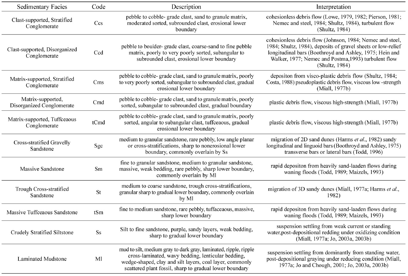
묘곡층, 울련산층 및 동화치층에서 대표적인 노두를 선정하여 암상, 입도, 조직 및 퇴적구조 등을 기재하고 이러한 특징들을 기준으로 퇴적상을 분류하였다. 총 11개의 퇴적상으로 구분하였고 각각의 특징을 표 2에 정리하였다. 또한 퇴적상들의 수평적·수직적 분포, 반복적인 산출 정도 및 접촉 관계를 고려하여 6개의 퇴적상조합으로 분류하였다.
Description and interpretation of sedimentary facies in the study area.
기재: 퇴적상조합 1은 소규모의 곡사층리를 보이는 중립에서 조립질 사암상(St) 및 세립질 내지 중립질의 괴상 사암상(Sm)과 엽층리가 발달한 흑색 이암상(Ml)이 교호하며 두껍게 발달한다. 이 상조합은 특징적으로 묘곡층에서만 산출된다(그림 2).

(a) Trough cross-bedding Sandstone (St). (b) Close-up of clast- to matrix (Ccd). (c, d) Flat-lying coarse gravels showing crude stratification of the Myogok Formation at Site 1. (e, f) Rare gravels in sandy matrix.
소규모의 곡사층리를 보이는 중립~조립 사암상(St)은 묘곡층 노두에서만 나타나는 상으로, 수 m 두께를 보이는 사암층(그림 3a, 3b, 3c)이 흑색 셰일과 교호하며 발달하는 양상이다. 간혹 왕모래에서 세립 자갈 크기의 역이 미약한 층리를 따라 배열되어 있거나 불규칙하게 산재해 있고(그림 3d, 3e, 3f), 비교적 분급이 양호하며 각 층의 두께는 수 십 cm 에서 수 m 정도이다. 측방 연장성은 양호하지 않으며, 하부 경계에는 뚜렷한 침식면이 발달해 있다.

(a) Massive Sandstone (Sm) of the Myogok Formation. (b, c, d) Yellow arrows show mud chips and rip-up clasts in massive sandstone of the Myogok Foramtion at Site 7.
곡사층리가 발달한 사암상(St)은 사질의 사구가 측방 또는 하류 방향으로 이동 축적하여 형성된 퇴적체이다(Cant and Walker, 1976; Miall, 1977a; Harm et al., 1982; Feary, 1984; Díaz-Molina, 1993; Røe and Hermansen, 1993).
괴상의 사암상(Sm)은 묘곡층에서만 나타나는 상으로, 세립에서 중립질 모래로 구성되고(그림 4a), 암색은 연회색(N7) ~ 암회색(N4), 황회색(5Y 7/2)이다. 일부 자갈 크기의 역을 소량 함유하며, 괴상이다. 분급은 양호하고, 하부에 이암이 존재할 경우, 상부 사암 내에 1~10 cm 정도의 머드칩이나 rip-up clast를 포함하고 있는 것이 관찰된다(그림 4b, 4c, 4d). 각 층의 두께는 수 cm에서 수 m 이상이며 측방 연장성은 좋지 않은 편이다. 흑색 이암상과 접한 층의 경계가 뚜렷한 편이다.

Photographs and columnar logs of Facies Association I. (a) Paralleled laminated mudstone. (b) Sharp contacts between trough cross-stratified fine sandstone and underlying laminated mudstone. (c) Interbeded massive sandstone and laminated mudstone. (d) Sketched columnar logs of Facies Association I (St: Trough cross-stratified sandstone, Ml: Laminated mudstone, Sm: Massive sandstone).
괴상의 사암상은(Sm)은 호수로 유입되는 하천 지류들이 하도 폭의 확장과 유속의 감소에 의해 운반되던 다량의 퇴적물을 호수 내에서 빠르게 가라앉히며 형성되었다. 저밀도 하천류 또는 홍수류의 competence가 급격히 낮아져 호수 바닥에 빠르게 축적된 것으로 해석된다(Lowe, 1982; Nemec and Steel, 1984; Todd, 1989; Maizels, 1993; Kim et al., 1995). 괴상의 사암상은 수 cm에서 수 m 두께로 흑색 이암층과 교호하며 나타난다. 측방 연장성이 양호하며 층의 상·하부 경계는 뚜렷한 침식면을 가지며 묘곡층에서만 산출된다.
엽층리가 발달한 이암상(Ml)은 묘곡층에서만 산출되는 퇴적상으로, 엽층리가 발달해 있다(그림 5a, 5b). 중암회색(N4)에서 암회색(N3)의 암색을 띠고, 사엽층리, 연흔, 상승연흔 등 퇴적구조들이 잘 관찰된다(그림 5c, 5d, 5e). 재산천 바닥 노두를 따라 다량의 식물 파편 화석이 발견되고, 얇은 탄층이 협재해 있다. 흑색 이암과 셰일이 교호하는데 상·하부 셰일을 경계로 이암 내에 석회질 단괴가 관찰된다(그림 5f, 5g, 5h). 층의 하부 경계에서는 파동 층리, 렌즈상 층리, 쐐기형 층이 관찰되거나 뚜렷한 침식면을 보인다.

(a) Outcrop of laminated mudstone (Ml). (b) Laminated mudstone with wavy bedding (yellow arrow) of lower boundaries. (c, d) Ripple of the the Myogok Formation at Site 5. (e) Climbing ripple of the Myogok Formation at Site 5. (f) Pseudo-nodule of the Myogok Formation at Site 6. (g, h) Calcareous nodule of the Myogok Formation at Site 10.
엽층리가 발달한 이암상(Ml)은 호수와 같이 정지된 수체에 부유 퇴적물을 함유한 유체가 유입되면서 형성한 퇴적체이다. 세립질 입자가 우세하게 퇴적되고 쪼개짐이 발달한 점은 저에너지의 환경에서 부유한 퇴적물이 느리게 침전되어 형성된 것으로 보인다. 또한, 다량의 식물 파편들이 세립질 입자와 함께 이동 후 낙하하여 많은 식물 화석들을 포함하고 있으며, 겹겹이 쌓여 얇은 탄층을 형성했을 것으로 해석된다. 퇴적물 내에 상당량의 유기물이 존재하고, 퇴적될 때 또는 퇴적 이후에도 무산소 환경을 유지하여 암회색 내지 흑색의 암색을 띠는 것으로 보인다(Miall, 1977a; Jo and Chough, 2001; Jo, 2003a, 2003b).
해석: 퇴적상조합 1은 저에너지 환경인 습지 또는 호수에서 부유하던 세립질 퇴적물이 침전하면서 퇴적된 것으로 해석된다. 분지 내외에서 공급된 상당량의 유기물이 호수로 유입되어 이질 퇴적물과 혼합되어 암회색 내지 흑색을 띠는 이암을 형성된 것으로 해석된다. 곡사층리를 보이는 세립질 사암 또는 괴상의 조립질 사암층은 홍수기 때 간헐적으로 퇴적물이 공급되는 소규모의 하천 지류에 의해 퇴적되었다고 해석하였다. 사암 내에 끼어있는 역들은 홍수에 의해 호수 내부로 유입되어 퇴적되었거나 분지 주변 단층대를 따라 호수 연변부를 통해 가까운 호수 내부로 유입되어 퇴적되었다고 해석된다(Miall, 1977a; Jo and Chough, 2001; Jo, 2003a, 2003b).
기재: 퇴적상조합 2는 기질 지지의 무질서한 역암상(Cmd)과 역 지지의 무질서한 역암상(Ccd)으로 구성되어 있다. 역들은 화강암, 편암, 규암 등으로 구성되며 분급은 매우 불량하고 원마도는 아각형에서 아원형이다. 각 역암 단위들은 수 십 cm에서 수 m의 두께를 가지며 측방연장성이 양호하다. 상부 층의 경계는 점이적 변화를 보이거나 역들이 불규칙하게 배열되어 있다(그림 6). 이 상조합은 특징적으로 울련산층과 동화치층에서만 산출된다.

Photographs and columnar log of Facies Association II. (a) Matrix-supported, disorganized conglomerate. (b) Clast-supported, disorganized conglomerate showing poor sorting and sub-rounded to rounded roundness. (c) Irregular contacts between clast-supported, disorganized conglomerate and matrix-supported, disorganized conglomerate. (d) Sketched columnar log of Facies Association II (Cmd: Matrix-supported, disorganized conglomerate, Ccd: Clast-supported, disorganized conglomerate).
기질 지지의 무질서한 역암상은(Cmd)은 울련산층과 동화치층 전반에 걸쳐 나타나는 상으로, 자갈에서 왕자갈 크기의 역들이 실트에서 왕모래 크기의 기질에 의해 지지되어 있고(그림 7), 층리 없이 무질서하게 배열되어 있는 역들은 편암과 편마암, 규암, 퇴적암편, 변성암편 등이 주를 이루며, 안산암, 사암, 흑색 이암 등이 소량 포함한다(그림 7). 역의 분급은 불량한 편인데, 역의 형태는 타원형이 우세하고 역의 원마도는 아각형에서 아원형 정도이다. 역암이 실트암 내에 렌즈상 또는 포켓 형태로 끼어있거나, 아래로 오목한 형태의 깎고 채운 구조로 나타나기도 한다(그림 7e, 7f). 각 층 단위의 두께는 수 십 cm 이거나 수 m 이상이다. 측방으로의 층 두께 변화는 거의 없고, 연장성이 좋은 편이다. 층의 상부와 하부 경계는 뚜렷하지 않고 점이적이거나 역에 의해 울퉁불퉁한 경계를 갖는다.

(a) Matrix-supported Disorganized Conglomerate (Cmd) of the Donghwachi Formation at Site 1. (b) Matrix-supported Disorganized Conglomerate (Cmd) of the Donghwachi Formation at Site 2. (c) Matrix-supported Disorganized Conglomerate (Cmd). (d) Cmd slab of the Ullyeonsan Formation at Site 1. (e) Pocket-shaped conglomerate. (f) Conglomerate pockets scouring into reddish siltstone of the Donghwachi Formation at Site 1.
기질 지지의 무질서한 역암상은(Cmd)은 기복이 심하고 풍화와 침식이 빠른 기원지로부터 운반된 다양한 크기의 퇴적물을 포함하며 점성이 있는 쇄설류(visco-plastic debris flow)에 의해 빠르게 운반되어 가까운 거리의 퇴적지에 축적되어 형성된 것으로 해석된다(Pierson, 1981; Nemec and Steel, 1984; Shultz, 1984). 큰 역이 층의 중간에 떠 있는 것은 기질이 다량 함유되어 점성이 큰 쇄설류에 의해 퇴적되었음을 지시한다(Miall, 1977b; Johnson, 1984; Nemec and Steel, 1984; Shultz, 1984; Costa, 1988). 또한, 일정한 배열이 없고 구성 입자의 범위가 큰 것, 측방 연장성이 매우 양호한 것은 거친 표면을 따라 흘러 퇴적되었을 때 나타나는 특징이다(Billi, 1991). 실트암 내에 협재한 렌즈상 역암상은 소규모의 하도 지류 내에서 퇴적되었음을 지시한다.
역 지지의 무질서한 역암상(Ccd)은 울련산층 중부와 동화치층 하부에서 나오는 상으로, 자갈에서 거력 크기의 역들과(최대 직경 약 44 cm; 그림 8) 실트(silt)에서 세립 자갈 크기의 기질을 포함하며 역 지지의 조직을 보이고(그림 8b, 8d), 층리 없이 역이 무질서하게 배열되어 있다. 역들은 편암과 편마암, 규암, 변성규암 등으로 주로 구성되어 있으며, 안산암, 장석반암과 같은 화산암과 안구상 편마암, 변성암편, 퇴적암편(셰일) 등 다양한 역을 소량 함유한다(그림 8). 역의 분급은 불량한 편이며 특히 기질의 분급이 매우 불량하다. 역의 형태는 타원형이 우세하지만 판형, 입방체 등 다양하게 나타나고, 역의 원마도는 아각형에서 아원형 정도이다. 각 층 단위의 두께는 수 십 cm 에서 수 m 내외로, 측방으로의 층 두께 변화는 거의 없고, 측방 연장성이 매우 좋다. 하부 경계는 역에 의해 울퉁불퉁하고 비침식적이다(그림 8a).

(a, b) Clast-supported Disorganized Conglomerate (Ccd) of the Ullyeonsan Formation at Site 2. (c, d) Clast-supported Disorganized Conglomerate (Ccd) of the Donghwachi Formation at Site 1.
역 지지의 무질서한 역암상(Ccd)은 역질의 판상 사구 또는 낮은 각도를 갖는 종사주 퇴적체에서 나타날 수 있으며, 홍수 시 역질 사주 표면에 큰 역들이 밑짐으로 운반·퇴적되고, 유속이 줄면서 작은 모래 입자들이 역 사이를 충진하여 기질을 이룰 때 형성된다(Boothroyd and Ashley, 1975; Hein and Walker, 1977; Nemec and Postma, 1993). 역을 다량 포함하며, 점토의 함량이 많고, 층리를 이루지 않고 배열되는 특징은 점착력 및 응집성이 있는 쇄설류에 의해 퇴적되었음을 지시한다(Johnson, 1984; Nemec and Steel, 1984; Shultz, 1984). 또한, 분급이 불량하며, 측방 연장성이 양호한 것은 이들을 퇴적시킨 홍수류가 뚜렷하게 구획되어 있지 않은 지표면을 흘러 퇴적되었음을 지시한다(Billi, 1991).
해석: 퇴적상조합 2는 쇄설류와 고농도 홍수류에 의해 주로 퇴적분지 가장자리의 단층 절벽을 따라 연속적으로 분포하는 전형적인 충적선상지 환경에서 형성된 퇴적상조합이다(Nemec and Steel, 1984; Shutlz, 1984; Blair, 1999; Ryang and Chough, 1999; Sohn et al., 1999; Benvenuti, 2003; Sohn and Son, 2004). 두꺼운 역암(Cmd & Ccd)에서 특별한 방향성 없이 배열되어 있고 불량한 분급, 양호한 측방 연장성을 보이는 특징은 거대한 고밀도 홍수류에 의해 뚜렷하게 구획되어 있지 않은 하도를 따라서 역들이 급하게 퇴적되었음을 지시한다.
기재: 퇴적상조합 3은 기질 지지의 무질서한 응회암질 역암상(tCmd)과 기질 지지의 무질서한 역암상(Cmd)으로 구성되어 있다. 기질 지지 응회암질 역암의 기질은 암녹색을 띤다. 하부에 퇴적된 응회암질 역암이 상부의 쇄설성 기질 지지 역암 내로 뜯겨져 올라가 포켓 또는 렌즈상으로 나타나기도 한다. 특히 응회암질 기질 내의 역들은 쇄설성 퇴적물로만 이루어진 역암의 역들과 달리 각진 형태로 규칙적인 배열 없이 산재해 있다. 기질 지지 역암의 기질은 적색 실트 내지 모래 크기로 발달한다. 각 역암 단위의 층후는 수 m 정도이며, 점이적으로 변하거나 뚜렷한 침식 경계면을 보이며 산출된다. 울련산층에서 산출된다(그림 9).

Photographs and columnar log of Facies Association III. (a) Grayish matrix-supported, disorganized conglomerate and dark greenish matrix-supported, disorganized, tuffaceous conglomerate. Rip-up clasts of tuffaceous conglomerate. (b, c) Thin section of tCmd. Trachytic texture with plagioclase laths surrounded by phenocrysts or arranged in a certain direction. (d) Sketched columnar log of Facies Association III (tCmd: Matrix-supported, disorganized, tuffaceous conglomerate, Cmd: Matrix-supported, disorganized conglomerate).
기질 지지의 무질서한 응회질 역암상(tCmd)은 울련산층 중부 일부 노두에서 산출하는 상으로, 자갈에서 왕자갈 크기의 역들이(최대 직경 약 13 cm) 모래에서 왕모래 크기의 기질에 의해 지지 되어 있고, 역들이 pale green (10G 6/2), grayish green (10G 4/2) 정도의 색을 가지는 응회질 기질에 둘러싸여 있다(그림 10). 역들은 규암, 화강암, 안산암, 퇴적암 등으로 주로 구성되어 있으며, 편마암, 퇴적암편, 변성암편이 소량 함유되어 있다. 역의 분급은 매우 불량하다. 역의 형태는 판상, 입방체 등 다양하고, 역의 원마도는 다른 역암상과는 달리 응회질 기질 내에 있는 역의 경우, 상대적으로 각진 형태를 가진다(그림 10c, 10d). 실트암 내에 포켓 형태의 역암(Cmd)이 산출하는 형태와 마찬가지로, tCmd 퇴적상에서도 아래로 오목한 형태를 갖는 모습이 상부 역암(Cmd)의 적색 실트 기질 내에서 관찰된다(그림 10b). 층 단위는 수 m 이상의 두께를 보이는데, 단일 노두에서 하나의 퇴적상으로 15 m 이상 두꺼운 층후를 보이기도 한다. 측방으로 층 두께 변화는 거의 없고, 연장성이 좋은 편이고 층의 상부 경계면은 뚜렷한 침식구조가 잘 나타난다(그림 10e, 10f).

(a) Matrix-supported Disorganized Tuffaceous Conglomerate (tCmd) and Matrix-supported Disorganized Conglomerate Cmd) Sharp and non-erosional lower contact of conglomerate. (b) Conglomerate pockets scouring into Cmd (red dotted line). (c, d) Angular clasts in tuffaceous matrix (black arrows) of the Ullyeonsan Formation at Site 4. (e) Subrounded clasts in tuffaceous matrix (f) the Donghwachi Formation at Site 6. Thickness of outcrop is more than 15 m.
기질 지지의 무질서한 응회질 역암상(tCmd)의 퇴적 과정은 Cmd 와 동일하게 높은 점성을 가진 쇄설류에 의해 퇴적된 것으로(Miall, 1977b; Johnson, 1984; Nemec and Steel, 1984; Smith, 1986), 간헐적인 화산 활동으로 인해 분지 주변에서 공급된 화산쇄설성 물질이 쇄설성 퇴적물과 함께 섞여 퇴적된 것으로 해석된다.
기질지지의 무질서한 역암상은(Cmd)은 앞서 FA 1에서 기술한 바 있다.
해석: 퇴적상조합 3은 퇴적 당시 분지 가장자리의 단층 절벽을 따라 분포하는 충적선상지 환경으로 재이동된 다량의 역들이 화산 활동에 의해 공급되는 화산쇄설물 또는 쇄설성 기질과 혼합되어 형성한 쇄설류 및 고농도 홍수류에 의해 퇴적된 것으로 해석된다(Johnson, 1984; Nemec and Steel, 1984; Shultz, 1984; Smith, 1986).
기재: 퇴적상조합 4는 기질 지지의 층리가 발달한 역암상(Cms)과 기질 지지의 무질서한 역암상(Cmd)이 희미하게 층리가 발달한 실트암상(Ss)과 교호하는 형태로 발달한다. 울련산층 중부와 동화치층 전반에 걸쳐 산출된다(그림 11).

Photographs and columnar logs of Facies Association IV. (a, b) Interbedded matrix-supported, disorganized conglomerate and crudely stratified siltstone. (c) Well stratified conglomerate and underlying disorganized conglomerate. (d) Sketched columnar log of Facies Association IV (Cms: Matrix-supported, stratified conglomerate, Ss: Crudely stratified siltstone, Cmd: Matrix-supported, disorganized conglomerate).
기질 지지의 층리가 발달한 역암상(Cms)은 동화치층 하부 Site 1 노두에서만 관찰되는데, 자갈에서 거력 크기의 역들이 실트에서 왕모래 크기의 기질에 의해 지지되어 있고, 비교적 양호한 층리를 보이는 것이 특징이다(그림 12a, 12b). 역들은 주로 편암과 편마암, 규암이고, 소량의 화강암, 사암, 셰일 등이 함유되어 있다. 역의 분급은 불량한 편이나, 같은 층을 따라 역들이 배열되어 있는 편이다. 역의 형태는 긴 타원형, 판상, 입방체 등 다양하고, 역의 원마도는 아각형에서 아원형 정도이다. 특징적으로, 정점이층리 및 역 점이층리가 함께 발달해있다. 각 층 단위의 두께는 수 m 내외이며, 측방으로의 층 두께 변화는 거의 없고, 연장성이 매우 좋다. 수직적으로 점이적인 암상 변화를 보이거나, 역에 의해 울퉁불퉁한 하부 경계면을 갖기도 하고 대체로 뚜렷한 침식 경계면을 보인다.

(a) Matrix-supported Stratified Conglomerate (Cms) Clasts are arranged along the bedding plane clearly. (b) Inverse grading (white triangles) and close-up of clast to matrix (Donghwachi Formation at Site 1) The scale bar is 8 cm long.
기질 지지의 층리가 발달한 역암상은(Cms)은 점성을 가진 쇄설류에 의해 퇴적된 형태이다(Miall, 1977b; Shultz, 1984; Costa, 1988). 정점이층리는 쇄설류나 고농도류의 유속이 급격하게 감소할 때 큰 입자가 우선적으로 쌓이고 이후에 작은 입자가 축적되면서 형성된다. 또한, 역의 상호 접촉 지지에 의한 분산 압력이 작용하여 기저 층리면에 세립질 퇴적물이 집적되거나, 역들 간의 상호 충돌이 크게 일어난 경우 역 점이층리가 형성되기도 한다(Lowe, 1979; Pierson, 1981; Postma et al., 1983; Numec and Steel, 1984; Shultz, 1984; Sohn, 1997).
희미한 층리가 있는 실트암상(Ss)은 울련산층 일부, 동화치층 전반에 걸쳐 산출하는 퇴적상으로, 미약한 층리를 보이거나 쪼개짐이 발달해 있다(그림 13a, 13b) 암색은 회적자색(5RP 4/2) 정도이고, 희미한 층리를 따라 조립질 왕모래와 자갈이 배열되어 있다. 역질의 사암층과 교호하며 나타나거나, 기질 지지의 층리가 발달한 역암상(Cms), 기질 지지의 무질서한 역암상(Cmd)과 함께 산출된다. 각 층의 두께는 수 cm 에서 수 m 에 이른다. 측방으로의 두께 변화는 거의 없고, 연장성은 양호하다. 상부 및 하부 경계면은 점이적이거나 뚜렷한 침식면을 보인다(그림 13c, 13d)

(a) Outcrop of fissile siltstone (Ss) (Donghwachi Formation at Site 3). (b) Thin sandy stratification in siltstone (yellow arrow) (Donghwachi Formation at Site 1). (c) Intervening reddish silt layers in sandy layers (Donghwachi Formation at Site 3). (d) Showing a non-erosive but irregular lower surface (Myogok Formation at Site 1).
희미한 층리가 있는 실트암상(Ss)의 암색이 적색 및 자줏빛을 띠는 것은 퇴적 당시 지하수면이 꽤 지표면 아래에 위치하고 있어 산화 상태로 노출된 환경에서 퇴적되었거나, 오랜 운반 과정 동안 겪은 풍화작용으로 인해 퇴적물 표면이 산화철에 의해 채색되어 쌓인 것으로 해석된다(Freytet and Plaziat, 1982; Wright, 1989; Alexander and Gawthorpe, 1993). 또한 약한 흐름의 하천류에 의해 퇴적된 것으로 해석된다(Miall, 1977a; Jo, 2003a, 2003b).
기질 지지의 무질서한 역암상(Cmd)은 앞서 FA 1에서 기술한 바 있다.
해석: 퇴적상조합 4는 대개 선상지 상부 환경에서 하류방향으로 이동한 쇄설류 또는 하천류가 교호하며 퇴적한 것으로 해석된다. 층리가 뚜렷하고 기질 지지를 갖는 역암은 역질 망상하천 내에서 발달한 저각의 종사주 또는 판상 역암 기원으로 추정된다(Boothroyd and Ashley, 1975; Boothroyd and Nummedal, 1977; Miall, 1977a; Todd, 1989; Brierley et al., 1993). 층리는 발달해 있지만 대규모 판상 사층리나 측방 누적에 의한 고각도 사층리가 나타나지 않는 것으로 보아 하도의 수심이 매우 얕았을 것으로 해석된다(Miall, 1977a; Brierley et al., 1993). 역암층이 포켓 또는 렌즈상으로 나타나는 것은 침식된 하도를 빠르게 채운 것으로 해석되며 역암 사이에 분포하는 적색의 실트암은 주로 홍수류의 유속이 줄어들면서 하도 유기가 일어난 곳으로 세립의 모래 또는 실트 입자들이 퇴적된 것으로 해석된다. 이에 따라 퇴적상조합 4는 충적선상지에 위치하던 역질의 망상하도 환경에서 퇴적된 것으로 해석된다.
기재: 퇴적상조합 5는 사층리가 발달한 역질의 사암상(Sgc)과 희미한 층리를 보이는 실트암상(Ss)이 교호하는 퇴적상조합이다. 동화치층에서만 산출된다(그림 14).

Photographs and columnar logs of Facies Association V. (a) Interbedded gravelly sandstone and reddish siltstone. (b) Interbedded clast-supported, stratified conglomerate and gravelly cross-stratified sandstone. (c) Sketched columnar log of Facies Association V (Ccs: Clast-supported, stratified conglomerate, Sgc: Gravelly cross-stratified sandstone, Ss: Crudely stratified siltstone).
사층리가 발달한 역질의 사암상(Sgc)은 동화치층 하부와 중부에서 산출되는 퇴적상으로, 조립질 왕모래에서 왕자갈 크기의 역들이 모래에서 세립질 왕모래크기의 기질 내 층리를 따라 배열되어 있거나 불규칙하게 산재해 있다(그림 15). 역의 분급은 양호한 편인데 모양은 타원형으로 원마도는 아원형 정도이다. 역질층과 사질층이 수 십 cm 내외로 교호하며, 내부 침식면이 없고, 층간의 뚜렷한 경계는 없다(그림 15b). 사암 내에는 층리를 따라 역질 띠가 10 cm 미만의 두께로 나타나며(그림 15c, 15d), 적색 실트암층이 협재해 있다(그림 15e). 저각도의 판상 사층리가 발달해 있고(그림 15a, 15e), 측방으로의 층 두께 변화는 거의 없고, 연장성이 좋은 편이다. 하부 경계면은 뚜렷한 침식면을 보이거나 역에 의해 울퉁불퉁한 경계를 보인다(그림 15d).

(a) Cross-Stratified Gravelly Sandstone (Sgc) Low-angle inclined gravelly sandstone. (b) Couplet of gravelly sandstone and sandy siltstone layers. (c, d) Flat-lying thin gravel sheet within gravelly sandstone (Sgc) Note that non-erosive lower surface and indistinct upper surface (Donghwachi Formation at Site 1). (e) Erosional lower bedding plane of cross-stratified gravelly sandstone and crudely stratified siltstone. (f) Scattered gravels in sandy sandstone (Donghwachi Formation at Site 3).
사층리가 발달한 역질의 사암상(Sgc)은 하천류에 의해 운반되어 하도 내에서 형성된 사주의 측방 이동이나 하류 방향으로의 이동에 의해 축적된 것으로 해석된다(Miall, 1977a; Cant and Walker, 1978; Feary, 1984; Díaz-Molina, 1993; Røe and Hermansen, 1993). 역질층과 사질층의 불명확한 교호현상은 퇴적물의 공급이 일정하지 않고 간헐적으로 조립의 역들이 공급되었거나 유속의 요동에 기인한 결과로 추정된다(Rhee and Chough, 1993a, 1993b). 같은 속도의 유체 내에 뜬짐으로 운반되는 모래 입자들과 밑짐으로 운반되는 역들이 유속의 급변으로 상당한 전단 응력의 요동이 발생하면 다양한 입자 크기의 모래와 역들을 동시에 퇴적시킬 수 있을 것이다(Walker, 1975).
희미한 층리가 있는 실트암상(Ss)은 앞서 FA 4에서 기술한 바 있다.
해석: 퇴적상조합 5는 선상지 또는 선상지 평원에서 하천류에 의해 퇴적된 것으로 해석된다. 역질층과 사질층의 불규칙적인 교호현상은 퇴적될 당시 퇴적물의 공급이 일정하지 않고 간헐적으로 조립의 역들이 공급되었거나 유속의 요동에 기인한 결과로 추정된다(Rhee and Chough, 1993a, 1993b). 하나의 유체 내에 운반되는 뜬짐과 밑짐이 유속의 급변으로 다른 크기의 입자들을 동시에 퇴적시킬 수 있기 때문이다(Walker, 1975). 유속에너지가 높아지면서 판상 역암 또는 역지지 역암층이 형성되고 종사주 또는 횡사주의 횡적 이동에 따라 사층리가 형성된 것으로 보인다. 따라서 퇴적상조합 5는 충적선상지 또는 선상지 평원 내 수심이 얕은 사질 망상하천 환경에서 퇴적된 것으로 해석된다.
기재: 퇴적상조합 6은 괴상의 응회질 기질이 발달한 사암상(tSm)이 반복되는 상조합으로, 사암층의 층후는 10 m 이상 두껍다. 사암층 내에는 자갈에서 왕자갈 크기의 역들이 산재하고 있다. 상하부 층의 경계는 정합관계를 보인다. 동화치층에서만 산출된다(그림 16).

(a, b) Thick Massive Tuffaceous Sandstone (tSm) of the Donghwachi Formation at Site 5. (c, d) Massive sandstone and irregular gravel clasts to sand matrix of the Donghwachi Formation at Site 6.
괴상의 응회질 사암상(tSm)은 동화치층 중부에서만 산출되는 상으로, 세립에서 중립질 모래의 입자 크기를 가지며 괴상이다. 일부 자갈 크기의 역이 불규칙하게 박혀 있고(그림 17d), 암색은 연녹색(10G 6/2), 회녹색(10GY 5/2, 5G 5/2) 정도이다. 단일 퇴적상으로 10 m 이상 두껍게 나타나며, 하부 경계는 뚜렷한 침식면을 가진다(그림 17a, 17b, 17c).

Photographs and columnar log of Facies Association VI. (a) Tuffaceous, massive sandstone with more than 10 m thickness. (b, c) Thin section of tSm. Trachytic texture with plagioclase laths surrounded by phenocrysts or arranged in a certain direction (Pl: Plagioclase). (d) Sketched columnar log of Facies Association VI (tSm: Tuffaceous, massive sandstone).
괴상의 응회질 사암상은(tSm) 괴상의 사암상을 퇴적시킨 퇴적 작용과 마찬가지로 유속의 흐름이 크게 감소하면서 다량의 사질 퇴적물을 포함하는 유체가 매우 빠르게 축적되며 형성한 퇴적체이다(Todd, 1989; Maizels, 1993). 층의 뚜렷한 하부 침식 경계면은 이동 중에 난류가 있었음을 지시한다(Shultz, 1984). 분지 주변에서 분포하던 화산체의 간헐적인 화산 활동으로 공급된 화산쇄설물과 쇄설성 사질 퇴적물이 섞여 퇴적된 것으로 해석된다.
해석: 퇴적상조합 6은 퇴적분지 주변에서 발생한 간헐적인 화산 활동으로 인해 공급된 화산쇄설물이 사질의 쇄설성 퇴적물과 섞여 형성한 쇄설류에 의해 빠른 속도로 재퇴적된 것으로 해석된다(Smith, 1986).
5. 토 의
5.1 퇴적환경
묘곡층은 퇴적상조합 1이 단일로 나타나는데, 퇴적상조합 1은 유수의 에너지가 낮은 호수 환경에서 우세하게 산출되는 퇴적체이다. 곡사층리를 보이는 세립의 사암은 호수 가장자리를 중심으로 퇴적되었으며, 곡사층리의 형성은 비교적 빠른 유속으로 퇴적물이 유입되고 유로 내 사구의 측방 이동에 의해퇴적되었다는 것을 의미한다. 엽층리가 발달한 흑색 이암이 두꺼운 층후를 보이는 것은 어느 정도 유기물을 함유한 퇴적물이 정지된 호수의 무산소 환경 하에서 오랜 기간 큰 환경 변화 없이 축적된 것으로 해석된다. 또한 식물 화석 및 탄층이 형성된 것은 호수 주변으로부터 다량의 식물 파편들이 유입되고 퇴적 이후 매몰되어 열적 성숙에 의한 속성작용을 경험한 것으로 해석된다. 흑색 이암과 교호하는 세립 내지 중립질의 괴상 사암은 간헐적으로 발생한 홍수에 의해 비교적 큰 입자들이 빠른 유속을 가지고 호수 내로 운반되어 이질층 상부에 퇴적된 것으로 해석된다. 또한 호수 주변에서 분포하던 가까운 기원지로부터 조립 퇴적물이 빠르게 유입되며 호수 가장자리를 따라 역을 포함한 괴상의 사암들을 퇴적시킨 것으로 해석된다. 이에 따라 묘곡층은 소규모의 하도에 사질 입자들이 유입되고 간헐적으로 하도 범람이 주변부에서 일어났던 저에너지의 호수 환경으로 해석된다(그림 18).

Columnar log and schematic diagram of the reconstructed depositional environment for the Myogok Formation (Facies Association I). (a) columnar log showing interbedded Ml and Sm, and St and Ml. (b) The Myogok Formation was deposited in a low energy lacustrine environment with intermittent floods.
그러나 묘곡층은 습곡 등의 구조 변형이 많고 야외에서 양호한 상태의 노두가 소규모로 분포하고 있으며 주향과 경사가 좁은 공간 내에서도 빠르게 변하기 때문에 이번 연구에서 제시하는 주상도 자료가 다소 미흡하긴 하나 기존의 유일한 묘곡층의 퇴적환경을 제시한 연구인 Chun et al. (1991)에서는 묘곡층을 포인트바 환경으로 해석한 결과와 비교하면, 식물편 등 유기물을 다량 함유하는 엽층리의 흑색 이암층이 두껍게 분포하고 간헐적으로 사암층이 협재하는 점을 고려하면 소규모의 하도 유입이 있는 호수환경으로 해석하는 것이 보다 타당한 것으로 판단된다.
울련산층은 퇴적상조합 2, 3, 4가 반복하여 산출되는데, 퇴적상조합 2, 3, 4의 산출 빈도는 유사하다. 퇴적상조합 2는 분지 주변 단층 절벽을 따라 발달한 충적선상지 상부에서 퇴적된 퇴적체로, 퇴적상조합 3은 간헐적인 화산 활동에 의해 퇴적분지 주변에서 공급된 화산쇄설물이 역을 다량 함유한 쇄설성 퇴적물과 섞여 형성한 쇄설류에 의해 퇴적된 퇴적체로 해석된다. 퇴적상조합 4도 선상지 상부의 역질 망상하도에서 형상된 것으로 해석된다. 따라서 울련산층은 단층 절벽에서 형성된 거대한 쇄설류가 거친 지표면을 따라 이동하며 다양한 크기의 역들을 선상지 상부에 급하게 퇴적시키다가 좀 더 하류방향으로 이동하며 역질 사암층을 망상하도에 형성한 것으로 추정되며, 이 시기에 간헐적으로 화산쇄설물도 공급되었된 것으로 해석된다(그림 19).

Columnar log and schematic diagram of the reconstructed depositional environment for the Ullyeonsan Formation and columnar log of the Ullyeonsan Formation (Facies Association II, III & VI). (a) Columnar log. (b) The Ullyeonsan Formation was deposited in an alluvial fan environment with intermittent volcaniclastic deposit .
동화치층은 퇴적상조합 2, 4, 5, 6이 다양하게 산출되는 퇴적환경이다. 특히 퇴적상조합 4와 퇴적상조합 5가 우세하게 산출된다. 퇴적상조합 4는 충적선상지에 위치하는 역질 망상하도 퇴적체로 해석되고, 퇴적상조합 5는 충적선상지 또는 선상지 평원에 위치하던 사질 망상하도 퇴적체로 해석된다. 암상의 반복양상과 퇴적구조 등의 특징들을 종합해보면, 동화치층은 울련산층과 마찬가지로 퇴적분지 주변에서의 간헐적으로 화산 활동에 의해 화산쇄설물이 유입되는 퇴적환경이나, 화산쇄설물 유입 빈도와 양은 울련산층 퇴적시기보다 더 많았던 것으로 추정된다. 즉, 화산쇄설물과 사질 쇄설물들이 섞여 형성한 쇄설류 또는 하천류에 의해 공급된 퇴적물이 선상지 또는 선상지 평원에 역질과 사질의 망상하천을 형성하고, 점차 하류 방향으로 가면서는 범람원 환경으로 전이한 퇴적환경에서 퇴적된 것으로 해석된다(그림 20).

Columnar log and schematic diagram of the reconstructed depositional environment for the Donghwachi Formation and columnar log of the Donghwachi Formation (Facies Association II, IV, V & VI ). (a) Columnar log (b) The Donghwachi Formation was deposited from an alluvial fan to a braided channel environment with intermittent volcaniclastic deposit.
5.2 묘곡층과 영양소분지 퇴적층과의 암상 및 지질구조 차이
묘곡층은 다른 지역에 분포하는 경상분지의 최하부 퇴적층들과는 상이한 암상을 보인다. 경상분지 서쪽 경계부를 따라 분포하는 최하부층인 신동층군의 낙동층과 하산동층, 그리고 영양소분지 동쪽 경계부인 영덕 일대에 분포하며 영양소분지 최하부층으로 추정되고, 신동충군 진주층과 대비되는 경정동층에서는 묘곡층의 대표적인 암상인 엽층리를 가지며 두꺼운 흑색 이암층은 산출되지 않는다. 또한, 묘곡층에서는 낙동층과 하산동층의 대표적인 암상인 적색 실트암과 역암은 산출되지 않는다.
습곡 구조를 잘 보여주는 묘곡층 노두(Site 2)는 묘곡 부근에 위치해 있는데, 습곡축의 경사각은 약 60° 정도로 비교적 고각으로 휘어져 있다(그림 21a, 21b). 하부 흑색 셰일과 상부 사암의 습곡 양 날개가 동일한 자세를 보이며 휘어져 있고, 현미경 관찰을 통해서는 복결정질의 석영 입자가 일정한 방향으로 길게 신장되어 나타나고, 3 mm 정도의 입자로 길게 신장된 형태로서 서로 맞물려 봉합된 입자 경계를 가지는 석영으로 구성된 규암 암편도 포함되어 있다(그림 21c, 21d). 규암편 안에 같은 방향으로 신장된 석영 광물은 주변에 다른 석영 입자의 내부 균열 방향과 다른 것으로 보아 2차적인 변성 작용을 받은 것으로 보인다(그림 21e, 21f). 그러나 같은 묘곡층 내부에서도 갈산 스러스트와 대곡단층 묘곡층 하부에서는 보다 심하게 변형된 구조들이 발달하는 반면 묘곡층 중부 이후부터는 상대적으로 변형된 구조가 덜 발달하고 비교적 일정한 주향 및 경사를 갖는다(그림 5a, 5b).

(a, b) Outcrop of the Myogok Formation. High angle (90°) close fold is shown. (c-f) The quartz grains elongated in the same direction in quartzite seem to have undergone a secondary metamorphism in which their orientation is different from the direction of internal cracking of other quartz grains. Qt: Quartz, Pl: Plagioclase, Ms: Muscovite, Bt: Biotite, Rf: Rock fragment, Opm: Opaque mineral, x40.
전체적으로 구조적인 측면에서 최하부층인 묘곡층은 대체로 N-S 주향에 동쪽 또는 서쪽으로 불규칙한 경사 방향을 보이며(그림 1), 심한 변형을 받은 습곡 구조, 파쇄나 압쇄작용에 의해 광물이 깨지고 신장한 구조가 잘 관찰된다. 그러나, 상위 퇴적층인 울련산층에서는 습곡 구조나 변형된 광물의 형태가 잘 관찰되지 않는다. 묘곡층과 접하는 위치에 있는 층의 하부에서 일부 노두의 주향 경사가 일정하지 않은 양상을 보이기도 하나 상부로 갈수록 평균적으로 N50°W/40°SW 정도의 일정한 주향과 경사를 보인다.
이와 같이 묘곡층은 상부의 울련산층과 동화치층은 서로 상이한 암상 특징을 가질 뿐만 아니라 포함하고 있는 지질구조도 다른 경향을 보이는 점은 퇴적층 퇴적 이후 경험한 구조변형 조건이 동일하지 않았다는 증거이며, 두 퇴적층 사이에는 긴 지질 시간의 공백이 있었고 상부의 울련산층이나 동화치층이 퇴적되기 이전에 하부의 묘곡층만 경험한 한반도 지구조운동이 있었던 것으로 추정된다.
5.3 묘곡층 퇴적 공간의 형성과 이후 진화
쥐라기 초기 이후 쥐라기 말까지 지속적으로 한반도에 전역에 영향을 끼친 것으로 추정되는 대보조산운동에 의해 충상단층과 습곡작용에 수반된 우수향 연성전단작용이 옥천변성대 남쪽 주변을 따라 발생했다고 알려져 있는데, Lim and Cho (2012)는 대보조산운동이 중기 쥐라기~후기 쥐라기 초에서 전기 백악기(~135 Ma 이전)까지 지속되었다고 보고한 바 있고, 이러한 구조운동은 대보조산운동의 두 번째 변형단계가 끝나갈 무렵 동아시아 대륙에 광역적인 인장운동을 유발하여 백악기 퇴적분지를 형성할 수 있었다고 설명하였다(Chough et al., 2000; Chough and Sohn, 2010). 또한, 최근 묘곡층 내 기질과 화산암 역에서 추출한 쇄설성 저어콘에 대한 절대연령 측정 결과는 묘곡층의 최고 퇴적 시기가 138.6 ± 2.1 (n=7) Ma (Lee, 2016)를 고려하면 묘곡층의 퇴적 시기는 백악기 전기인 발란지니안 또는 호테리비안 후기로 해석한 바 있는데(Kang et al., 2012), 묘곡층의 지질구조의 형성과 다른 경상분지 퇴적층인 낙동층(Hauterivian 시기)의 비변형 상태를 고려하면 묘곡층의 퇴적 시기는 백악기 전기인 발란지니안으로 보는 것이 타당할 것으로 판단된다.
이러한 연구결과를 고려하면 묘곡층 퇴적물을 저장하고 있는 퇴적공간은 쥐라기 말-백악기 초까지 지속된 대보조산운동과 연계된 지구조 운동에 의한 인장운동의 결과로 현재의 경상분지 북서단에 좁고 깊은 함몰대로서 형성되었고, 함몰대 내에 묘곡층이 퇴적된 이후, 새로운 울련산층 퇴적층이 형성된 엡티안(Aptian) 시기까지의, 부정합으로 대표되는 13 my 정도의 긴 공백기 동안 영향을 준 구조운동에 의해 단층과 인접한 곳의 퇴적층에는 변형 구조가 형성된 것으로 해석된다.
그러나 이러한 지각 운동은 경상분지 북부 영양소분지에서 울련산층이 퇴적되기 시작하는 엡티안 이전에는 종료되어(Chough and Sohn, 2010) 경상누층군 퇴적층에 속하는 울련산층에는 거의 영향을 주지 않아 울련산층에서는 묘곡층에서 보이는 것과 같은 뚜렷한 변형 구조가 보이지 않고 비교적 일정한 방향으로의 층의 연장이 나타난다고 해석된다. 또한 묘곡층(호성 환경)과 울련산층(선상지 상부 환경) 간의 상이한 퇴적환경은 두 퇴적층 퇴적 시기 사이의 긴 기간 동안 발생한 대규모 단층에 의해 백악기 중기 이후 새로운 퇴적 공간이 크게 조성되었고 퇴적환경도 완전히 변화되어 울련산층 퇴적물을 선상지 환경에 축적하다가 이후 망상하천 범람원 환경으로 점차 전이된 것으로 추정된다(그림 22).

Schematic diagrams of the depositional and tectonic history of the Myogok Formation in the Yeongyang Subbasin of the Gyeongsang Basin (Ages from Lee, 2016).
Stage 1: 함몰지 형성(묘곡층 퇴적 이전): 현재의 경상분지 영양소분지 북서쪽 일대, 선경상기 기반암인 원남층 위에 쥐라기 말-백악기 초까지 지속된 대보조산운동과 연계된 지구조 운동에 의한 인장운동의 결과로 소규모로 깊은 골(trough) 내지는 함몰지(depression)가 생겨나 퇴적층이 쌓일 수 있는 공간이 형성되었다(Chough et al., 2000).
Stage 2: 묘곡층 퇴적(138 Ma~): 소규모의 하도를 통해 유수가 함몰지 내로 유입되면서 호수가 형성되기 시작하여 비교적 빠른 퇴적 속도로 세립 내지 중립질의 입자가 퇴적되었는데 곡사층리를 갖는 사암층도 호수 가장자리에 퇴적되기 시작했다. 유속에너지가 점차 감소하면서 호수환경과 같은 정지된 수체 내로 세립질 입자가 침전되어 호수 중심부에는 엽층리가 발달한 두꺼운 흑색 이암층이 퇴적되었다. 간헐적으로 일어나는 비교적 큰 규모의 범람이나 국지적으로 발생하는 지구조 운동으로 인해 호수 가장자리를 따라 큰 입자들이 빠르게 운반 퇴적되면서 상부 층으로 갈수록 흑색 이암 사이에 괴상의 중립 내지 조립질 사암층이 점차 빈번하게 협재하며 교호하는 양상을 보인다. 따라서 묘곡층은 좁고 깊은 함몰지 내에 세립 내지 조립의 사암과 흑색 이암이 산출되는 호수 퇴적환경에서 형성되었을 것으로 해석된다. 주요 퇴적물은 석영을 다량 공급할 수 있는 규암 또는 화강암질 기반암으로 구성된 근원지에서 유래했을 것으로 보인다.
Stage 3: 지각 변동(묘곡층 퇴적 이후): 묘곡층은 현재 북쪽에서는 갈산스러스트, 북동쪽에서는 대곡단층에 의해 원남층과 단층 접촉을 하며 분포하고 있다. 묘곡층 퇴적 이후 융기작용에 의해 원남층과 묘곡층 하부 사암의 상당 부분이 삭박되어 현재 야외에는 비교적 얇은 층후의 세립 내지 중립의 사암과 두꺼운 흑색 이암이 쐐기 형태로 소규모로 노출되어 있다고 유추된다. 묘곡층 퇴적 이후 백악기 초기에 한반도 동남부는 일본 열도의 후배호 환경에 위치하며 인장력의 영향을 받아 경상분지가 형성되었다(Lee and Chough, 1999). 이 시기의 동아시아는 전반적으로 압축환경에서 인장환경으로 지구조 변화가 있었던 것이 보고되었다(Lee, 2016). 묘곡층이 퇴적되고 울련산층이 쌓이기 전인 약 13 my 기간 동안에는(Chough and Sohn, 2010; Lee, 2016) 지구조 운동 방향의 변화로 압축력이 우세하여 지반의 융기작용이 일어났던 것으로 해석된다.
Stage 4: 울련산층 퇴적(125 Ma~) (Chough and Sohn, 2010): 묘곡층과 울련산층은 부정합으로 접해있다. 정합적인 관계라면 울련산층 하부 접촉부에 하부층인 묘곡층의 대표적인 암상인 흑색 이암과 같은 퇴적암이 층내암편(intraclast)의 형태로 산출되어야 하지만 전혀 발견되지 않는 것으로 상당한 시간 간격이 있는 부정합 접촉으로 추정된다. 현재 노출되어 있는 묘곡층의 분포지가 워낙 좁고 울련산층과 직접 접촉하는 노두가 드물어 발견되지 않았을 가능성도 있지만, 묘곡층의 퇴적 이후 울련산층이 쌓이기 전까지 약 13 my 기간 동안 융기되어 일부 묘곡층을 포함한 기존 퇴적층들은 삭박되고 그 상부에 부정합적 관계를 가지며 울련산층이 쌓인 것으로 해석된다. 울련산층을 구성하고 있는 주요 역암의 역들은 분급이 매우 불량하고 뚜렷한 층리 없이 무질서하게 배열되어 있는 점이 특징적이다. 또한 주요 역들은 편암, 편마암 등 대부분 결정질 기반암 기원이다.
울련산층이 퇴적되는 초기에는 큰 규모의 지구조운동으로 인해 퇴적공간인 분지는 깊고 분지의 경계 또한 급사면을 이루고 있었을 것이다. 유입된 울련산층 초기의 퇴적물들은 비교적 근거리에 있는 단층 절벽과 같이 융기된 기반암에서 매우 빠른 속도로 쇄설류에 의해 공급되었을 가능성이 크다. 또한 울련산층의 중·상부에서부터는 화산쇄설물을 기질로 갖는 역암이 산출되는데, 이는 퇴적분지의 동쪽 바깥에서 발생한 간헐적인 화산 활동을 통해 공급된 화산쇄설물이 역을 다량 포함하는 화산쇄설류를 형성해 운반한 것으로 해석된다. 당시 마그마는 지표 가까이에서 냉각되었거나 지표로 올라오기 전 이미 부분적으로 냉각된 화산암의 특성이 모두 나타나는 안산암질 마그마였던 것으로 해석된다.
Stage 5: 동화치층 퇴적: 동화치층을 구성하고 있는 주요 역암은 하부 퇴적층인 울련산층에 비해 분급이 비교적 양호하고 아원형을 보이는 역들이 증가하며 층리를 따라 뚜렷하게 배열된 것이 특징적이다. 울련산층에서 산출되는 역암상과 상당한 차이가 있다. 이는 분지 주변의 지각운동이 완화되고 퇴적물을 공급하는 근원지가 퇴적지로부터 점차 더 멀어진 것으로 보인다. 또한, 당초 다량의 퇴적물을 운반하던 쇄설류가 희석되어 층리를 발달시키기 좋은 고농도의 하천류로 변화한 것으로 해석된다. 이에 따라 상부로 가면서 사층리가 발달한 역질 사암과 적색 실트암이 교호하는 양상을 보이며 최상부에서는 역의 함량이 감소하고 두꺼운 층후의 적색 실트암의 비율이 높아진다. 이는 역질의 망상하천 환경에서 사질이 우세한 망상하천 환경과 제방을 넘어 범람원 환경으로 퇴적환경이 점차 전이하였다는 것을 의미한다.
하부의 울련산층과 마찬가지로 동화치층에서도 화산쇄설물과 쇄설성 퇴적물이 섞인 퇴적체가 산출된다. 울련산층 퇴적층에서 보이는 화산쇄설성 퇴적체보다 층후가 더 두껍게 나타나고 역을 소량 포함하고 있으며 사질 퇴적물과 섞인 퇴적체의 산출 빈도가 높다. 이는 울련산층이 퇴적되던 시기보다 화산 활동이 더 빈번하게 일어났으며 화산쇄설물이 더 멀리서부터 공급되었기 때문으로 추정된다.
6. 결 론
묘곡층과 경상분지 영양소분지의 하부 퇴적층인 울련산층, 동화치층에 대하여 암상, 입도, 조직, 퇴적구조, 층 형태 등을 기준으로 총 11개의 퇴적상으로 분류하고 6개의 퇴적상 조합으로 구분하였다.
묘곡층은 퇴적상조합 1이 단일로 나오는 환경으로 호성 퇴적환경으로 해석되고 울련산층은 퇴적상조합 2와 퇴적상조합 3이 우세하게 산출되는 환경으로 간헐적으로 화산쇄설물이 공급되는 충적선상지 상부 퇴적환경으로 해석된다. 동화치층은 퇴적상조합 4와 퇴적상조합 5가 우세하게 산출되는 환경으로 간헐적으로 화산쇄설물이 공급되며 충적선상지 중부와 그 하부에 위치해 있는 역질 및 사질의 망상하천에서 범람원으로 전이하는 퇴적환경으로 해석된다.
퇴적학적 특징 및 구조적인 특징을 바탕으로 영양소분지의 하부퇴적층이 퇴적되는 과정을 5단계로 구분하여 해석하였다. Stage 1은 영양소분지 북서쪽 일대에서 지각 운동에 의해 좁고 깊은 함몰지가 형성되던 시기이고, Stage 2는 소규모의 하도가 유입되는 호수환경에서 묘곡층이 퇴적되던 시기이다. Stage 3은 남북방향의 압축력에 의해 지반이 융기하여 묘곡층의 상당 부분이 삭박되고 묘곡층 내에 여러 변형 구조가 형성된 시기이고, Stage 4는 단층 절벽을 따라 유입된 퇴적물이 묘곡층 위에 부정합으로 울련산층을 퇴적시킨 시기이며, 마지막으로 Stage 5는 울련산층 위에 정합으로 동화치층이 퇴적된 시기이다.
이번 연구에서는 묘곡층이 야외 노두에서 매우 협소하게 소규모로 분포하여 지질학적인 해석을 수행하는데 다소 어려움이 있었기에 차후에는 지화적 분석과 같은 보다 다각적인 연구 방법을 활용하여 묘곡층 형성의 구조적인 원인과 퇴적물의 기원 등을 규명할 필요가 있다고 판단된다.
References
-
Alexander, J. and Gawthorpe, R.L., 1993, The complex nature of Jurassic multistorey, alluvial sandstone body, Whitby, North Yorkshuire. In: North, C.P. and Prosser, D.J. (eds.), Characterization of fluvial and aeolian reservoirs, Geological Society special Publications, 73, 123-142.
[https://doi.org/10.1144/GSL.SP.1993.073.01.08]

-
Benvenuti, M., 2003, Facies analysis and tectonic significance of lacustrine fan-deltaic successions in the Pliocene-Pleistocene Mugello Basin, Central Italy. Sedimentary Geology, 157, 197-234.
[https://doi.org/10.1016/S0037-0738(02)00234-8]
-
Billi, P., Magi, M. and Sargi, M., 1991, Pleistocene lacustrine fan delta deposits of the Valdarno Basin, Italy. Journal of Sedimentary Research, 61, 280-290.
[https://doi.org/10.1306/D42676EF-2B26-11D7-8648000102C1865D]
-
Blair, T.C., 1999, Cause of dominance by sheetflood vs. debris-flow processes on two adjoining alluvial fans, Death Valley, California. Sedimentology, 46, 1015-1028.
[https://doi.org/10.1046/j.1365-3091.1999.00261.x]
-
Boothroyd, J.C. and Ashley, G.M., 1975, Processes, bar morphology, and sedimentary structures on braided outwash fans, northeastern Gulf of Alaska. In: Jopling, A.V. and McDonald, B.C. (eds.), Glaciofluvial and Glaciolacustrine Sedimentation. Society of Economic Paleontologists and Mineralogists, Special Publication 23, 193-222.
[https://doi.org/10.2110/pec.75.23.0193]
- Boothroyd, J.C. and Nummedal, D., 1977, Proglacial braided outwash: a model for humid alluvial-fan deposits. Fluvial Sedimentology - Memoir, 5, 641-668.
-
Brierley, G.J., Liu, K. and Crook, K.A.W., 1993, Sedimentology of coarse-grained alluvial fans in the Markham Valley, Papua New Guinea. Sedimentary Geology, 86, 297-324.
[https://doi.org/10.1016/0037-0738(93)90027-3]
-
Cant, D.J. and Walker, R.G., 1978, Fluvial processes and facies sequences in the sandy braided South Saskatchewan River, Canada. Sedimentology, 25, 625-648.
[https://doi.org/10.1111/j.1365-3091.1978.tb00323.x]
- Chang, K.H., 1975, Cretaceous stratigraphy of South-east Korea. Journal of the Geological Society of Korea, 11, 1-23.
- Chang, K.H., 1977, Late Mesozoic Stratigraphy, Sedimentation and Tectonics of Southeastern Korea. Journal of the Geological Society of Korea, 13, 76-90 (in Korean with English abstract).
- Chang, K.H., 1988, Cretaceous stratigraphy and paleocurrent analysis of Kyongsang Basin, Korea. Journal of the Geological Society of Korea, 24, 194-205.
- Chang, K.H. and Park, S.O., 1997, Aspects of tectonics and volcanism recorded in Cretaceous medial Kyongsang Basin, SE Korea. Economic and Environmental Geology 30, 143-151 (in Korean with English abstract).
-
Chang, K.H., Suzuki, K., Park, S.O., Ishida, K. and Uno, K., 2003, Recent advances in the Cretaceous stratigraphy of Korea. Journal of Asian Earth Sciences, 21, 937-948.
[https://doi.org/10.1016/S1367-9120(02)00142-6]
- Cheong, C.H. and Lee, H.Y., 1966, The Myogog Formation and Its Tectonic Significance. Journal of the Geological Society of Korea, 2, 21-35.
-
Choi, H.I., 1986, Fluvial plain/lacustrine facies transition in the Cretaceous Sindong Group, south coast of Korea. Sediment Geology, 48, 295-320.
[https://doi.org/10.1016/0037-0738(86)90034-5]
-
Chough, S.K., Kwon, S.T., Ree, J.H. and Choi, D.K., 2000, Tectonic and sedimentary evolution of the Korean peninsula: a review and new view. Earth-Science Reviews, 52, 175-235.
[https://doi.org/10.1016/S0012-8252(00)00029-5]
-
Chough, S.K. and Sohn, Y.K., 2010, Tectonic and sedimentary evolution of a Cretaceous continental arc-backarc system in the Korean peninsula: New view. Earth-Science Reviews, 101, 229-245.
[https://doi.org/10.1016/j.earscirev.2010.05.004]
- Chun, H.Y., Bong, P.Y., Choi, S.J., Kim, B.C., Kim, Y.B., Kwon, Y.I., Lee, H.Y., Lee, M.S. and Um, S.H., 1991, Stratigraphic and Palaeontologic Study of Myogog Formation, Korea Institute of Energy and Resources (KIER) Report, 1-77 (in Korean with English abstract).
-
Cluzel, D., Cadet, J.P. and Lapierre, H., 1990, Geodynamics of the Ogcheon belt South Korea. Tectonophysics, 183, 41-56.
[https://doi.org/10.1016/0040-1951(90)90187-D]
- Costa, J.E., 1988, Rheologic, geomorphic, and sedimentologic differentiation of water flood hyperconcentrated flows, and debris flows. In: Baker, V.R., Krfhel, R.C. and Patten, P.C. (eds.), Flood Geomorphology, Wiley, New York, 113-122.
-
Díaz-Molina, M., 1993, Geometry and lateral accretion patterns in meander loops: examples from the Upper Oligocene-Lower Miocene, Loranca Basin, Spain. In: Marzo, M. and Puigdefabreras, C. (eds.) Sepc. Publ. Int. Ass. Sediment, 17, 115-131.
[https://doi.org/10.1002/9781444303995.ch10]
-
Feary, D.A., 1984, The Boambolo Formation - A Silurian prograding fan-delta sequence in southeastern New South Wales, Australia, Sedimentary Geology, 39, 169-195.
[https://doi.org/10.1016/0037-0738(84)90049-6]
- Folk, R.L., 1974, Petrology of Sedimentary Rocks: Austin. Texas, Hemphill, Publishing Co., 182 p.
- Freytet, P. and Plaziet, J.C., 1982, Continental carbonate sedimentation and pedogenesis: Late Cretaceous and Early Tertiary of sourthern France. Contributions to Sedimentology, 12, 213 p.
- Harms, J.C., Souhtard, J.B. and Walker, R.G., 1982, Structures and Sequence in Clastic Rocks: SEPM Short Course, Society of Economic Paleontologists and Mineralogists, Calgary, 9, 249 p.
-
Hein, F.J. and Walker, R.G., 1977, Bar evolution and development of stratification in the gravelly, braided Kicking Horse River, British Columbia. Canadian Journal of Earth Sciences, 14, 562-570.
[https://doi.org/10.1139/e77-058]
-
Jo, H.R., 2003a, Depositional environments, architecture, and controls of Early Cretaceous non-marine successions in the northwestern part of Kyongsang Basin, Korea. Sedimentary Geology, 161, 269-294.
[https://doi.org/10.1016/S0037-0738(03)00130-1]
-
Jo, H.R., 2003b, Non-marine successions in the northwestern part of Kyongsang Basin (Early Cretaceous): Fluvial styles and stratigraphic architecture. Geosciences Journal, 7, 89-106.
[https://doi.org/10.1007/BF02910212]
-
Jo, H.R. and Chough, S.K., 2001, Architectural analysis of fluvial sequences in the northwestern part of Kyongsang Basin (Early Cretaceous), SE Korea. Sedimentary Geology, 144, 307-334.
[https://doi.org/10.1016/S0037-0738(01)00123-3]
- Johnson, A.M., 1984, Debris flow. In: Brunsden, D. and Prior, D.B. (eds.), Slope Instability, John Wiley & Sons, Chichester, 257-361.
- Kang, J.H., Hayasaka, Y., Katsube, A., Lee, D.S., Koh, S.M., Ryoo, C.R. and Noh, S.Y., 2012, SHRIMP zircon age of Gyemyeongsan Formation in the Eoraesan area, Chungju, Korea. Proceedings of the Annual Joint Conference, Mineralogical Society of Korea and Petrological Society of Korea, 73-75.
- Kang, J.H. and Lee, D.S., 2008, Geological structure around Andong fault system, Pungcheon-myeon, Andong, Korea. Journal of Petrological Society of Korea, 17, 83-94 (in Korean with English abstract).
- Kim, N.H., 2001, Metamorphism of Precambrian basement rocks of Pyeonghae-Uljin Area in the northeastern Sobaegsan massif, Korea. Master D. thesis, Pukyong National University, Pusan, 92 p (in Korean with English abstract).
- Kim, N.H., 2010, Petrology, geochemistry and geochronology study of Precambrian basement rocks in the Northeastern Yeongnam Massif, South Korea: their tectonic implications. Ph.D. thesis, Pukyong National University, Pusan, 19-60 (in Korean with English abstract).
- Kim, O.J., Hong, M.S., Park, H.I. and Kim, K.T., 1963, Explanatory text of the geological map of Samgun-ri sheet (SHEET 7024-IV SCALE 1:50000). Geological Survey of Korea, 1-6 (in Korean with English abstract).
- Kim, O.J., Hong, M.S., Park, H.I., Won, J.K., Park, Y.D. and Kim, K.T., 1963b, Explanatory text of the geological map of PyongHae-ri sheet (SHEET 7024-II SCALE 1:50000). Geological Survey of Korea, 1-8 (in Korean with English abstract).
- Kim, O.J., Hong, M.S., Won, J.K., Park, H.I., Park, Y.D. and Kim, K.T., 1963c, Explanatory text of the geological map of Togye-dong sheet (SHEET 7024-III SCALE 1:50000). Geological Survey of Korea, 1-4 (in Korean with English abstract).
-
Kim, S.B., Chough, S.K. and Chun, S.S., 1995, Bouldery deposits in the lowermost part of the Cretaceous Kyokpori Formation, SW Korea: cohesionless debris flows and debris falls on a steep-gradient delta slope. Sedimentary Geology, 98, 97-119.
[https://doi.org/10.1016/0037-0738(95)00029-8]
-
Kozai, T., Ishida, K., Hirsch, F., Park, S.O. and Chang, K.H., 2005, Early Cretaceous non-marine mollusc faunas of Japan and Korea. Cretaceous Research, 26, 97-112.
[https://doi.org/10.1016/j.cretres.2004.11.003]
- Lee, D.J., Choi, Y.M., Lee, D.C., Lee, J.G., Kwon, Y.K., Cao, L. and Choh, S.J., 2013, Upper Ordovician and Silurian deposits in the Pyeongnam Basin: Songrim Conglomerate and its paleogeographic implication. Journal of the Geological Society of Korea, 49, 5-15 (in Korean with English abstract).
- Lee, D.S. and Lee, H.Y., 1963, Explanatory text of the geological map of Yean sheet (SHEET 6924-II SCALE 1:50000). Geological Survey of Korea, 1-6 (in Korean with English abstract).
-
Lee, S.H. and Chough, S.K., 1999, Progressive changes in sedimentary facies and stratal patterns along the strike-slip margin, northeastern Jinan Basin (Cretaceous), southwest Korea: implications for differential subsidence. Sedimentary Geology, 123, 81-102.
[https://doi.org/10.1016/S0037-0738(98)00087-6]
- Lee, T.H., 2016, Formation and evolution of the Gyeongsang Basin: constraints from zircon geochronology and Hf isotope geochemistry. Ph.D. thesis, Pukyong National University, Pusan, 21-22 (in Korean with English abstract).
-
Lim, C. and Cho, M., 2012, Two-phase contractional deformation of the Jurassic Daebo Orogeny, Chungnam Basin, Korea, and its correlation with the early Yanshanian movement of China. Tectonics, 31, TC1004.
[https://doi.org/10.1029/2011TC002909]
-
Lowe, D.R., 1979, Sediment gravity flows : their classification and some problems of application to natural flows and deposits. In: Doyle, L.J. and Pilkey, O.H. (Editors). Geology of Continental Slopes. Society of Economic Paleontologists and Mineralogists Special Publication, 27, 75-82.
[https://doi.org/10.2110/pec.79.27.0075]
-
Lowe, D.R., 1982, Sediment gravity flows 2: Depositional models with special reference to the deposits of high-density turbidity currents. Journal of Sedimentary Petrology, 52, 279-297.
[https://doi.org/10.1306/212F7F31-2B24-11D7-8648000102C1865D]
-
Maizels, J., 1993, Lithofacies variations within sand deposits: the role of runoff regime, flow dynamics and sediment supply characteristics. Sedimentary geology, 85, 299-725.
[https://doi.org/10.1016/0037-0738(93)90090-R]
-
Miall, A.D., 1977a, A review of the braided river depositional environment. Earth-Science Reviews, 13, 1-62.
[https://doi.org/10.1016/0012-8252(77)90055-1]
- Miall, A.D., 1977b, Lithofacies types and vertical profile models in braided river deposits: a summary. Fluvial Sedimentology - Memoir, 5, 597-604.
-
Nemec, W. and Postma, G., 1993, Quaternary alluvial fans in southwestern Crete: sedimentation processes and geomorphic evolution. In: Marzo, M. & Puigdefabregas, C. (eds.), Alluvial Sedimentation. IAS Spec. Publ., 17, 235-276.
[https://doi.org/10.1002/9781444303995.ch18]
- Nemec, W. and Steel, R.J., 1984, Alluvial and coastal conglomerates: Their significant features and some comments on gravelly mass-flow deposits. In: Koster, E.H. and Steel, R.J. (eds.), Sedimentology of Gravels and Conglomerates. Canadian Society of Petroleum Geologists, Memoir, 1-31.
-
Okada, H., 1971, Classification of sandstone: analysis and proposal. Journal of Geology, 79, 509-525.
[https://doi.org/10.1086/627673]
- Park, S.O., Kozai, T., Ishida, K. and Chang, K.H., 2003, Correlation of Early Cretaceous non-marine molluscan faunas of Korea and Japan. Journal of the Paleontological Society of Korea, 19, 1-20 (in Korean with English abstract).
-
Pierson, T.C., 1981, Dominant particle support mechanisms in debris flows at Mt Thomas, New Zealand, and implications for flow mobility. Sedimentology, 28, 49-60.
[https://doi.org/10.1111/j.1365-3091.1981.tb01662.x]
-
Postma, G., Roep, T.B., Ruegg, G.H.J., 1983, Sandy-gravelly mass-flow deposits in an ice-marginal lake (Saalian, Leuvenumsche Beek Valley, Veluwe, the Netherlands) with emphasis on plug-flow deposits. Sedimentary Geology, 34, 59-82.
[https://doi.org/10.1016/0037-0738(83)90035-0]
-
Rhee, C.W. and Chough, S.K., 1993a, The Cretaceous Pyeonghae Basin, southeast Korea: sequential development of crevasse splay and avulsion in a terminal alluvial fan. Sedimentary Geology, 83, 37-52.
[https://doi.org/10.1016/0037-0738(93)90181-4]
-
Rhee, C.W. and Chough, S.K., 1993b, The Cretaceous Pyonghae sequence, southeast Korea: terminal fan facies. Palaeogeography, Palaeoclimatology, Palaeoecology, 105, 139-156.
[https://doi.org/10.1016/0031-0182(93)90112-V]
-
Røe, S.-L. and Hermansen, M., 1993, Processes and products of large, late Precambrian sandy rivers in northern Norway. In: Marzo, M., Puigdefa´bregas, C. (Eds.), Alluvial Sedimentation. Int. Assoc. Sedimentol., Spec. Publ., Blackwell Scientific Publications, Oxford, UK, 17, 151-166.
[https://doi.org/10.1002/9781444303995.ch12]
-
Ryang, W.H. and Chough, S.K., 1999, Alluvial-to-lacustrine systems in a pull-apart margin: southwestern Eumsung Basin (Cretaceous), Korea. Sedimentary Geology, 127, 31-46.
[https://doi.org/10.1016/S0037-0738(99)00018-4]
-
Shultz, A.W., 1984, Subaerial debris flow deposition in the Upper Paleozoic Cutler Formation, western Colorado. Journal of Sedimentary Petrology, 54, 759-772.
[https://doi.org/10.1306/212F84EF-2B24-11D7-8648000102C1865D]
-
Smith, G.A., 1986, Coarse-grained nonmarine volcaniclastic sediments: Terminology and depositional process. Geological Society of American Bulletin, 97, 1-10.
[https://doi.org/10.1130/0016-7606(1986)97<1:CNVSTA>2.0.CO;2]
-
Sohn, Y.K., 1997, On traction-carpet sedimentation. Journal of Sedimentary Research, 67, 502-509.
[https://doi.org/10.1306/D42685AE-2B26-11D7-8648000102C1865D]
-
Sohn, Y.K., Rhee, C.W. and Kim, B.C., 1999, Debris flow and hyperconcentrated flood-flow deposits in an Alluvial Fan, Northwestern part of the Cretaceous Yongdong basin, Central Korea. The Journal of Geology, 107, 111-132.
[https://doi.org/10.1086/314334]
-
Sohn, Y.K. and Son, M., 2004, Synrift stratigraphic pattern of a transfer zone coarse grained delta complex, Miocene Pohang Basin, SE Korea. Sedimentology, 51, 1387-1408.
[https://doi.org/10.1111/j.1365-3091.2004.00679.x]
-
Todd, S.P., 1989, Stream-driven, high-density gravelly traction carpets: possible deposits in the Trabeg conglomerate Formation, SW Ireland and some theoretical considerations of their origin. Sedimentology, 36, 513-530.
[https://doi.org/10.1111/j.1365-3091.1989.tb02083.x]
-
Walker, R.G., 1975, Conglomerate: sedimentary structures to facies models, Depositional environments as interpreted from primary sedimentary structures and stratification sequences. SEPM Short Course, 133-161.
[https://doi.org/10.2110/scn.75.01.0133]
- Won, C.K., Kang, P.C. and Lee, S.H., 1978, Study on the tectonic interpretation and igneous pluton in the Gyeongsang Basin. Journal of the Geological Society of Korea, 14, 79-92 (in Korean with English abstract).
- Wright, V.P., 1989, Paleosol recognition. In: Allen, J.R.L. and Wright, V.P. (eds.) Paleosols in siliciclastic sequences, Postgraduate Research institute for Sedimentology, University of Reading, 1-25.
- Yang, S.Y., 1976, On the non-marine molluscan fauna the Upper Mesozoic Myogog Formation, Korea. In: Transactions and proceedings of the Paleontological Society of Japan. New series, Palaeontological Society of Japan, 102, 317-333.
- Yang, S.Y., 1984, Paleontological Study on the Molluscan Fauna from Myogog Formation, Korea (pt-2). Journal of the Geological Society of Korea, 20, 15-27.
- Yi, M.S. and Chun, H.Y., 1993, Palynomorphs from the Myogog Formation, Korea, and their stratigraphic significance. Journal of the Geological Society of Korea, 29, 246-257 (in English with Korean abstract).
- Yu, K.M., 1994, Study on stratigraphy and albitization of sandstone from Myogog Formation. KOSEF 971-0401-001-2), 38 p (in Korean with English abstract).
- Yun, S.K., 1967, Explanatory text of the geological map of Jangseong sheet (Sheet 7025-III SCALE 1:50000). Geological Survey of Korea, 18 p (in Korean with English abstract).