구조운동 및 화산활동에 의해 조절되는 장기분지 성동리층 상부구간의 퇴적사

초록
장기분지에는 이산화탄소 지중저장을 위하여 8공의 시추코어가 회수되었다. 본 연구에서는 성동리층 상부구간의 관찰에 용이한 5개공을 이용하여 퇴적상 분석을 하였으며, 응회암 건층을 이용하여 퇴적단위를 나누고 구조운동, 화산활동에 따른 퇴적환경 변화를 고찰하였다. 퇴적단위 S-6은 두꺼운 엽리상 이암으로 구성된 호성 퇴적물(퇴적상조합 4)과 그 상부의 상향조립화 경향을 보이는 강어귀 및 저습지 퇴적물(퇴적상조합 3 및 퇴적상조합 5)로 이루어져 있다. 퇴적단위 S-7의 하부경계는 소규모 화산활동에 의한 응회질 퇴적물(퇴적상조합 6)로 구성되어 있으며, 그 상부는 주로 상향세립화 경향을 보이는 하성퇴적물(퇴적상조합 2)과 습지환경퇴적물(퇴적상조합 5)이 우세한 가운데 응회질 퇴적물(퇴적상조합 6)이 교호한다. 퇴적단위 S-8의 최하부는 응회암 건층이 관찰된 후 그 상부에 이질 습지환경 퇴적물(퇴적상조합 5)과 사질 하천 퇴적물(퇴적상조합2)이 우세하게 나타나는 가운데, 응회암(퇴적상조합 6)이 수차례 교호한다. 퇴적단위 S-9의 최하부는 흰색을 띠는 응회암 건층(퇴적상조합 6)이 나타난 후, 저습지 퇴적물(퇴적상조합 5)과 사질 하천 퇴적물(퇴적상조합 2)이 교호한다. 중부 구간에는 두꺼운 응회질 퇴적물이 나타나며, 이로 인한 퇴적물 공급량 증가로 상부에 역질 망상하천이 발달하기도 한다. 장기분지의 장기역암과 성동리층 하부구간은 역질 망상하천과 호성환경 퇴적물이 우세하며 분지 서쪽이 두껍고 동쪽이 얇은 쐐기형 분포양상을 보이나 성동리층 상부는 세립질의 습지 및 사행하천 퇴적물이 우세하며 두께 변화가 미미하다. 이는 장기분지 형성 초기에 발달한 일련의 당겨열림형 소분지들이 후기에 들어와 하나의 분지로 합쳐진 결과로 해석된다.
Abstract
In the Janggi Basin, 8 cores were drilled for underground carbon dioxide storage. In this study, sedimentary response to tectonics, sediment supply and volcanic eruption was speculated on the upper part of the Seongdongri Formation, using 5 drill cores. Depositional unit S-6 consists of a thick (20 - 30 m in thickness) lacustrine shale (FA4) and overlying mouthbar and swamp sediments with coarsening-upward trends (FA3 and FA5). The lower boundary of depositional unit S-7 is represented by thick volcaniclastic deposits (FA6) formed by dacitic volcanic activity and resedimentation. The volcaniclastic sediments were overlain by meandering stream sandstone with fining-upward trends (FA2) and swamp or floodplain mudstone (FA5). The lower boundary of the depositional unit S-8 is characterized by a thick (6 - 10 m in thickness) volcaniclastic tuff and is overlain by sandstone with fining-upward trend (FA2), deposited in meandering river, and homogeneous mudstone with organic matter (FA5), indicating swamp or floodplain environment. The lower boundary of depositional unit S-9 comprises a thick (~10 m in thickness), white volcanic tuff, and is overlain by floodplain or swamp mudstone (FA5) with intercalating meandering river sandstone (FA2). In the middle part, thick volcaniclastic sediments commonly occur, which are overlain by braided stream conglomerate (FA1), suggesting increase in sediment supply. In the Janggi Basin, the Janggi Conglomerate and the lower part of the Seongdongri Formation are dominated by braided stream and lake deposits with westward increase in bed thickness, showing a wedge-shape distribution pattern in cross-section. The upper part of the Seongdongri Formation is, however, dominated by fine-grained meandering river and floodplain deposits without significant lateral variation in unit thickness, suggesting that, during the late stage of Janggi Basin development, small-scale subbasins were merged, forming a single basin.
Keywords:
Janggi Basin, Seongdongri Formation, volcanic activity, sediment supply, evolution of strike-slip basin키워드:
장기분지, 성동리층, 화산활동, 퇴적물 공급량, 당겨열림형 소분지1. 서 언
한반도 남동부에 위치한 장기분지는 우수향 전단력으로 형성된 전기마이오세의 당겨열림형 분지(pull-apart basin)들 중 하나로 주요 단층 및 지층 자세를 기준으로 하여 구룡포지괴, 오천지괴, 뇌성산지괴, 영암리지괴, 양포소분지로 구분된다(Gu et al., 2018; Kim, 2018). 당겨열림형 분지의 발달에 있어서 구조 운동은 퇴적수용 공간 변화를 야기하며, 퇴적물 공급량, 해수면 및 기후 변화, 그리고 화산 활동 등의 요인이 복합적으로 작용하여 분지충전물의 퇴적양상이 결정된다(Gawthorpe and Leeder, 2000; Miall, 2000; Busby and Bassett, 2007). 특히 구조운동은 퇴적분지의 경계, 분지의 형태 및 규모를 결정하며, 분지 내부에도 단층을 형성하여 퇴적수용 공간 변화에 중요한 영향을 준다(Gerhard, 2000). 또한 우수향 혹은 좌수향의 주향이동 운동에 의해 일련의 당겨열림형 소분지들이 형성되며 주향이동 운동이 지속됨에 따라 초기에 형성된 여러 소분지들이 합쳐져 하나의 분지가 형성되기도 한다(Keighley et al., 2003; Scherer et al., 2015).
최근 Gu and Hwang (2017)은 뇌성산지괴 시추코어의 장기역암 퇴적상을 기재하고 대비하여 분지 내의 여러 단층운동에 의한 퇴적수용공간 변화와 그에 따른 퇴적환경 변화 및 퇴적사를 보고하였다. 또한 Gu et al. (2018)은 성동리층 하부구간의 시추코어와 야외노두 조사를 통해, 퇴적상조합의 급격한 수직적 변화와 데사이트질 화산물질을 건층으로 한 대비를 수행하였고 이를 통하여 단층운동에 의한 퇴적수용공간 변화와 화산활동에 의한 퇴적물 공급량 변화를 고찰하였다. 이 연구에 의하면, 장기역암 및 성동리층 하부의 각 퇴적단위 내에서는 퇴적상조합 및 두께의 급격한 수평변화가 확인되며, 이를 주향이동 단층운동이 활발한 시기에 퇴적된 것으로 해석하였다. 그러나 성동리층 상부는 장기역암 및 성동리층 하부와는 달리 퇴적상의 급격한 수평적, 수직적 변화가 적으며 이는 각 소분지들이 합쳐진 성숙기에 퇴적되었을 가능성을 제시한다.
장기역암 및 성동리층 하부는 Gu and Hwang (2017)과 Gu et al. (2018)에 의해 기존에 연구가 되어 왔으나 성동리층 상부에 대한 정밀한 층서대비 및 퇴적환경 분석, 구조 및 화산활동 분석은 아직까지 이루어지지 않고 있다. 따라서 본 연구에서는 아직까지 자세하게 밝혀지지 않았던 성동리층 상부구간의 퇴적환경 해석을 위해 총 5개의 시추코어를 이용, 응회암 건층을 활용하여 시추공 간 대비를 수행하여 퇴적단위를 구분하였고, 각 퇴적단위 내에서 퇴적환경의 수직적, 수평적인 변화를 고찰하였으며 이를 통하여 분지의 구조운동 및 퇴적작용을 규명하여 기존의 연구에 더하여 장기분지 전체의 퇴적사 연구의 이해에 도움이 되고자 하였다. 또한 기존의 장기역암, 성동리층 하부구간과 성동리층 상부구간의 퇴적상 및 두께 변화 등을 통하여 이를 유발한 구조운동 및 화산활동과의 연관성에 대한 분석을 수행하였고 더 나아가 울릉분지와 장기분지 사이의 연관성에 대하여 고찰하고자 한다.
2. 지질개요
한반도 남동부에는 후기 올리고세에서 초기 마이오세 사이 일본 열도가 한반도로부터 남동쪽 방향으로 분리됨에 따라, 동해가 북-남 혹은 북북서-남남동 방향으로 확장하게 되어, 우수향 전단력이 작용하였다(Han, 1987; Jolivet et al., 1991; Fabbri et al., 1996; Kim et al., 2011; Son et al., 2013, 2015; Yoon et al., 2014)(그림 1a). 이러한 우수향주향이동 운동에 의해 일련의 당겨열림형 초기 마이오세 분지들(북으로부터 장기, 와읍, 어일, 하서, 정자, 울산 분지)이 형성되었고, 장기분지는 이러한 전기 마이오세 분지 중 규모가 가장 큰 분지이다(Kim, I.S., 1992; Yoon, 1997; Son et al., 2007, 2013; Jung et al., 2012; Kim, M.C., 2018)(그림 1b).

(a) Tectonic movement around Ulleung Basin during the Early Miocene. Back-arc opening of the East Sea resulted in right-lateral strike-slip movement in the southeastern part of the Korean Peninsula (after Yoon et al., 2014). (b) The early Miocene Janggi, Waup, Eoil, Haseo, Jeongja basins were formed by northwest-southeast trending right-lateral strike-slip movement (after Son et al., 2015).
장기분지의 북서쪽은 오천단층을 경계로 중기 마이오세에 퇴적된 포항분지와 구분되고, 남쪽은 에오세 혹은 팔레오세 시기의 왕산층 기반암에 의해 와읍, 어일분지와 구분된다(그림 1b). 장기분지는 충전물의 상대연령과 단층, 구조적 침강 대비 등을 통하여 북으로부터 구룡포, 오천, 뇌성산, 영암리지괴와 양포소분지로 구분된다(Son et al., 2009, 2013; Cheon et al., 2012; Jung et al., 2012; Kim et al., 2015). 구룡포지괴는 범곡리층군 하부에 해당하는 퇴적물로 충전되어 있으며, 그 외의 지괴들은 모두 범곡리 상부에 대비되는 충전물이 나타난다(Kim, 2018). 즉, 구룡포지괴 내의 구룡포층과 공개산 데사이트질암에 대한 LA-MC-ICPMS U-Pb 방사성 동위원소 저어콘 연대측정을 실시한 결과 약 22.4~23 Ma로 나타나며, 이는 뇌성산지괴 내에 위치한 성동리층의 연대(20.22±0.13 Ma) 보다 오래된 것으로 확인되었다(Kim, 2018).
장기분지의 구룡포지괴 상부에 분포하는 뇌성산, 영암리지괴의 충전물은 하부로부터 장기역암, 성동리층, 뇌성산현무암질암으로 구분된다(Kim et al., 2011, 2015)(그림 2, 3). 최하부 장기역암은 후기 백악기 혹은 팔레오세 초 시기의 데사이트질 내지 유문암질 화산암 복합체로 이루어진 왕산층 기반암의 상부에 놓여있으며(Yoon, 1989; Shin, 2013; Gu and Hwang, 2017; Kim, 2018), 주로 역암과 사암으로 구성되어 망상하천 환경에서 퇴적된 것으로 해석된다(Gu and Hwang, 2017)(그림 3). 성동리층은 주로 데사이트질 응회암과 응회질 사암 그리고 쇄설성 퇴적물인 역암, 사암, 이암 등으로 이루어져 있어 화산활동과 함께 하성 및 호성환경에서 퇴적된 것으로 해석되었다(Kim et al., 2015; Gu et al., 2018)(그림 3). 최상부인 뇌성산현무암질암은 현무암과 현무암질 응회암으로 이루어져 있다(Kim et al., 2011, 2015; Jung et al., 2012; Gu et al., 2018)(그림 3).

Detailed geological map of the Janggi Basin with the locations of well sites (after Kim et al., 2015; Gim et al., 2016; Gu and Hwang, 2017; Gu et al., 2018).

Simplified columnar section of Janggi Basin cores (Gu and Hwang, 2017). Basin fill deposits can be divided into Janggi Conglomerate, Seongdongri Formation and Noeseongsan Basaltic Rocks, from bottom to top. For the locations of wells, see Fig. 2.
장기분지 퇴적물에 대한 기존의 연구는 야외노두와 시추코어를 이용하여 다양하게 이루어져 왔다. Bahk and Chough (1996)는 장기분지 영암리지괴의 노두를 연구하여, 화산활동기와 휴지기가 반복되었으며, 각각 화산쇄설물과 하성퇴적물이 퇴적되었던 것으로 해석하였다. 반면 Sohn et al. (2013)은 장기분지 양포소분지의 노두 조사를 통하여 하성퇴적물에 의한 광역적인 침식과 고토양의 흔적이 발견되지 않는 점을 근거로 화산 폭발에 의한 분지의 대규모 침강과 함께 퇴적물 공급량이 증가하여 형성된 하성퇴적물이라는 견해를 제시하였다.
한편, Gim et al. (2016)은 뇌성산지괴에서 획득된 시추코어를 통하여 성동리층 중부구간에 해당하는 데사이트질 화산쇄설물의 연구를 통해 일차적으로 퇴적된 화산쇄설물과 재동된 화산물질을 구분하였다. Gu and Hwang (2017)은 뇌성산지괴 시추코어의 장기역암 퇴적상을 기재하고 대비하여 분지 내의 여러 단층운동에 의한 퇴적수용공간 변화와 그에 따른 퇴적환경 변화 및 퇴적사를 보고하였다. 또한, Gu et al. (2018)은 성동리층 하부구간의 시추코어와 야외노두 대비를 통해 단층운동에 의한 퇴적수용공간 변화와 화산활동에 의한 퇴적물 공급량 변화를 데사이트질 화산물질을 건층으로 대비하여 해당시기의 퇴적 기작 및 퇴적환경에 대한 해석을 하였다.
3. 퇴적상 및 상조합 기재 및 해석
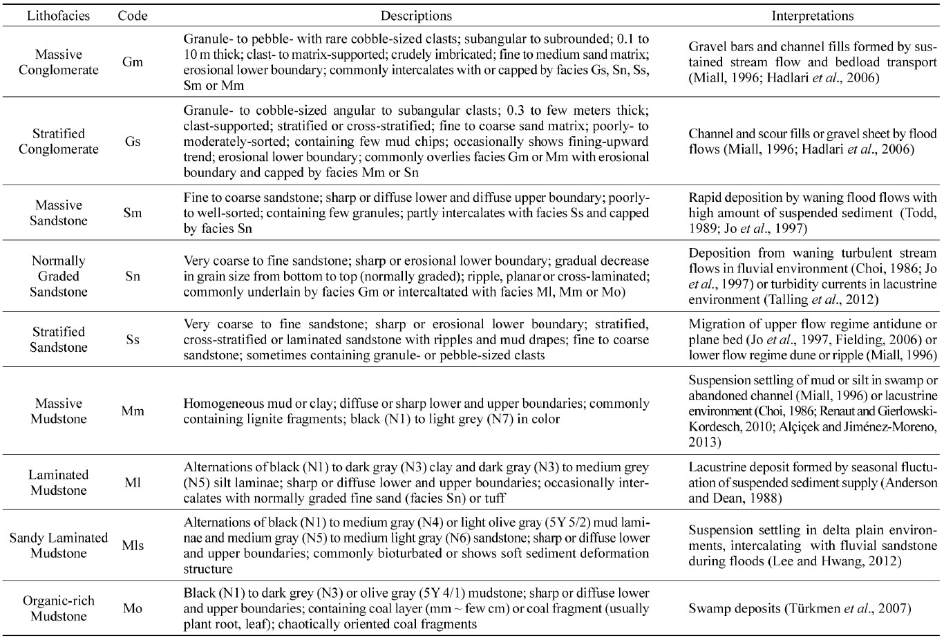
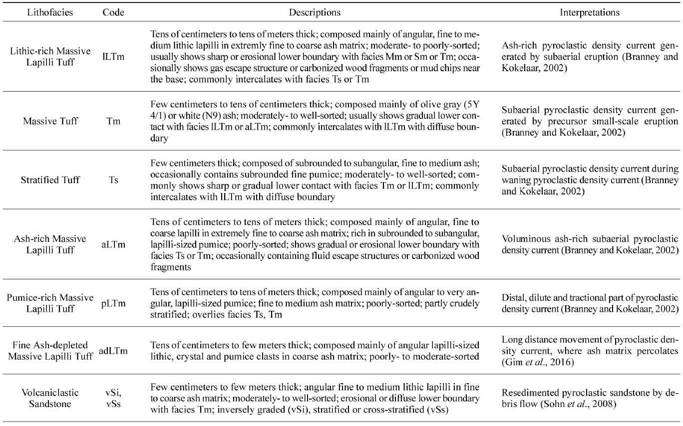
장기분지 장기역암과 성동리층 하부는 Gim et al. (2016), Gu and Hwang (2017)과 Gu et al. (2018)의 연구에 의해, 퇴적물의 입도, 색상, 조성 물질, 조직 및 퇴적구조 등을 바탕으로 쇄설성 퇴적상과 화산쇄설성 퇴적상으로 구분하였다(표 1, 2). 본 연구는 성동리층 상부구간의 퇴적상을 기재하고 해석하는 연구로, 기존 연구와 통일성을 위하여 이전 연구의 퇴적상 기재에 이용되었던 상분류 체계를 사용하여 9개의 쇄설성 퇴적상과 7개의 화산쇄설성 퇴적상으로 구분하였다(표 1, 2). 또한 시추코어에서 관찰되는 퇴적상의 수직 변화 양상을 바탕으로 6개의 퇴적상조합으로 분류하였다. 퇴적상조합 1은 주로 하부에 침식경계를 보이는 괴상역암으로 구성되어 있으며 상향세립화 경향을 보인다(그림 4a). 퇴적상조합 2는 상향세립화 경향을 보이는 사암층이고 퇴적상조합 3은 상향조립화 경향을 보이는 사암층이다(그림 4b, 4c). 퇴적상조합 4는 엽층리 이암이 우세하게 나타나며, 퇴적상조합 5는 유기물이 많이 함유된 괴상 이암 및 사암이 관찰된다(그림 5a, 5b). 또한 퇴적상조합 6은 주로 세립의 화산회 기질에 의해 지지된 화산력 응회암으로 구성되어 있다(그림 5c). 이번 연구에 사용된 시추코어는 JG-1, 3, 5, 6, 7-1호공으로 총 5개 이며, 변형 및 파쇄가 심하여 퇴적구조의 감별이 힘든 JG-2, 4호공은 제외하였다.

Description and interpretation of clastic sedimentary facies (modified from Gu and Hwang., 2017).
Description and interpretation of volcaniclastic sedimentary facies (modified from Gim et al., 2016).

(a) Columnar section and photograph of Facies Association 1 (FA1). Fining-upward trends of thick, coarse-grained conglomerate point to braided stream deposits. (b) Columnar section and photograph of Facies Association 2 (FA2). Fining-upward trends of sandstone with sharp, erosional lower boundary indicate meandering stream deposits. (c) Columnar section and photograph of Facies Association 3 (FA3). Note sandstone layers showing coarsening-upward trends with coaly shale, suggesting progradation of mouthbars into a swamp environment.

(a) Columnar section and photograph of Facies Association 4 (FA4). Laminated mudstone points to seasonal fluctuation in sediment supply to the lake environment. (b) Columnar section and photograph of Facies Association 5 (FA5). Massive mudstone (Facies Mm) and organic rich mudstone (Facies Mo) indicate deposition in swamp or floodplain environments. (c) Columnar section and photograph of Facies Association 6 (FA6). Note the tuff beds with volcanic ash.
3.1 퇴적상조합 1
기재: 퇴적상조합 1은 주로 괴상 역암(facies Gm)으로 구성되어 있고 층상 역암(facies Gs), 괴상 사암(facies Sm), 층상 사암(facies Ss), 점이층리 사암(facies Sn), 괴상 이암(facies Mm)도 협재되어 있다(그림 4a). 괴상역암(facies Gm)은 주로 하부에 위치한 이암 또는 사암과 침식경계를 가지며, 상부에 위치한 사암과는 희미하거나 뚜렷한 경계를 보인다. 괴상 역암(facies Gm)은 대부분 수 m 정도 두께로 일부 구간에서는 뜯어 올림 이암편이 나타난다. 역의 원마도는 아각형에서 아원형, 크기는 왕모래에서 잔자갈, 일부 왕자갈이 관찰되며 분급은 보통에서 불량이다. 대부분 입자지지 되어있으며 기질은 세립에서 조립질 사암으로 구성되어 있다. 괴상 역암은 주로 수 cm ~ 수십 cm 두께의 층상 역암(facies Gs) 내지 층상 사암(facies Ss)과 교호한다. 사암(facies Sm, Ss, Sn)은 수 cm ~ 수십 cm 가량의 두께로 관찰되며, 입도는 세립에서 조립까지 다양하나 이질 사암(muddy sand)도 확인된다. 괴상 이암(facies Mm)은 주로 역암이나 사암의 상부에 위치하고 유기물을 함유한다. 수 cm ~ 수십 cm 두께로 주로 어두운 회색을 띤다. 퇴적상조합 1은 전체적으로 상향세립화 경향을 보이며 수 m ~ 수십 m 두께로 퇴적상조합 2 혹은 퇴적상조합 5가 수십 cm ~ 수 m 이내로 협재한다(그림 4a). 퇴적단위 S-9에서 집중적으로 나타나며, 특히 5호공과 6호공에서 약 50 m 두께로 발달해 있다.
해석: 대부분 괴상의 역암으로 이루어져 있으며, 하부의 침식경계와 상향세립화 경향, 사암으로 된 기질로 보아 역질 하천 퇴적물로 해석된다(Miall, 1977; Hadlari et al., 2006; Lee and Hwang, 2012; Gu and Hwang, 2017). 괴상 역암(facies Gm)은 강한 유수에 의해 운반되어온 역들이 역질 하도 혹은 사주에서 퇴적된 것으로 판단되며, 괴상 역암과 교호하며 나타나는 층상 역암(faceis Gs)은 홍수기 동안의 강한 유수에 의한 밑짐운반 등에 의하여 형성된 역질 판상체로 해석된다(Miall, 1977; Hadlari et al., 2006; Gu and Hwang, 2017). 괴상 사암(facies Sm)은 홍수기 이후 감소된 유량 및 유속에 의해 역질 사주의 뒤편이나 표면에 사질 퇴적물이 급격하게 퇴적된 것으로 생각된다. 점이층리 사암(facies Sn)은 난류로 운반되던 사질 퇴적물이 유속이 약해지면서 퇴적된 것으로 해석된다. 한편 밑짐으로 운반되던 사질 퇴적물은 사주의 표면에 층상 사암(facies Ss)의 형태로 퇴적된 것으로 추정된다(Miall 1977; Jo et al., 1997; Lee and Hwang, 2012). 역암 혹은 사암의 상부에 위치하는 괴상 이암(facies Mm)은 범람원 혹은 유기된 하도 등에 뜬짐으로 운반된 세립 퇴적물이 침전된 것으로 해석된다(Todd, 1989; Potter et al., 2005; Gruszka, 2007).
3.2 퇴적상조합 2
기재: 퇴적상조합 2는 괴상 사암(facies Sm), 층상 사암(facies Ss), 점이층리 사암(facies Sn), 괴상 이암(facies Mm), 탄질 셰일(facies Mo)로 구성되어있다(그림 4b). 사암상(facies Sm, Ss and Sn)은 하부의 이암을 침식하고 상부는 점이적인 경계를 보이며 이암에 의해 피복된다. 상부로 갈수록 입도 및 층의 두께가 감소하는 상향세립화 경향을 보인다(그림 4b). 수 m 정도의 두께로 발달하며 세립에서 조립의 사암으로 구성되어있다. 이암은 괴상 이암(facies Mm)이 우세하며 탄질 셰일(facies Mo)도 분포한다. 괴상 이암(facies Mm)의 경우 갈탄조각을 함유하고 있으며, 탄질 셰일(facies Mo)에는 수 cm 두께의 탄층이 협재하기도 한다. 퇴적상조합 2는 퇴적상조합 5와 교호하며, 수 m에서 10 m 정도의 두께를 가진다. 퇴적상조합 2는 퇴적단위 S-6의 하부구간을 제외한 전 구간에 걸쳐 우세하게 분포한다.
해석: 하부에 침식경계를 보이며 상향세립화 경향을 나타내는 사암층은 사행하천의 사질하도 퇴적물로 해석된다. 하부의 침식경계는 하도가 이동함에 따라 범람원 내지 습지 환경에서 퇴적된 이암이 침식된 것으로 판단되며(Miall, 1977; Lee and Hwang, 2012), 하도의 유기, 홍수 이후의 유량 감소, 사주의 측면퇴적 등의 요인으로 인하여 상향세립화 경향이 나타나는 것으로 해석된다(Miall, 1977; Collinson, 1996; Bridge, 2006; Gu and Hwang, 2017). 괴상 이암(facies Mm) 및 탄질 셰일(facies Mo)은 수십 cm 정도 두께로, 상향세립화 경향을 보이는 사암의 상부에 희미한 경계를 가지며 분포하고, 이는 사질 하도의 유기 후 부유하던 점토 내지 실트가 하도를 채우며 퇴적되었거나, 하도 인근의 저습지 환경에서 퇴적되었던 것으로 추정된다(Miall, 1996; Ghazi and Mountney, 2009; Lee and Hwang, 2012).
3.3 퇴적상조합 3
기재: 퇴적상조합 3은 주로 엽층리 사질 이암(facies Mls), 정점이층리 사암(facies Sn), 층상 사암(facies Ss), 탄질 셰일(facies Mo)로 구성되어 있으며 상향조립화 경향을 보인다(그림 4c). 엽층리 사질 이암(facies Mls)은 수 cm ~ 수십 cm 두께로 관찰되고 박층의 사암이 수 mm ~ 수 cm 두께로 엽층리 이암 사이에 협재되어 있거나 교호하고 있다. 박층의 사암은 평행층리 혹은 저각사층리 구조를 보인다. 엽층리 사질 이암에는 생교란 흔적화석과 연성 퇴적물 변형구조(soft-sediment deformation structure)가 흔히 발견된다. 이암의 상부에 위치한 사암은 층상 사암(facies Ss)이 우세하고 점이층리 사암(facies Sn)과 침식 혹은 희미한 경계를 가지며 교호한다. 각 사암층의 두께는 수 cm ~ 수십 cm이고, 분급은 불량에서 보통이다. 층상 사암(facies Ss)은 평행층리 또는 사층리를 보이고 뜯어올림 역을 포함한다. 퇴적상조합 3은 주로 퇴적상조합 4 혹은 퇴적상조합 5의 상부에 위치하며, 퇴적단위 S-6 하부에 분포한다.
해석: 엽층리 사질 이암 혹은 탄질 셰일(facies Mls, Mo)은 뜬짐으로 공급된 실트 내지 점토가 느리게 침전된 범람원 혹은 습지환경에서 퇴적된 것으로 해석된다(Mader, 1985; Fralick and Zaniewski, 2012; Ghosh and Guchhait, 2013). 협재된 사암은 홍수시기에 습지 인근의 하도 등에서 국부적으로 공급된 것으로 추정된다. 이암 내의 생교란 흔적화석은 저에너지 환경을 지시하며 연성 퇴적물 변형구조는 이암 상부에 퇴적된 사암층의 하중에 의해 형성된 것으로 생각된다(Wijnhoven et al., 2006; Geraint et al., 2011; Boggs, 2014). 탄질 셰일(facies Mo)은 배수가 잘 되지 않는 저습지 환경에서 퇴적된 것으로 해석된다. 상향조립화 경향을 보이는 사암층(facies Sn, Ss)은 홍수기에 일시적으로 호수로 변하는 범람원 및 습지환경에 전진구축한 강어귀 사주(mouth bar)로 추정된다(Overeem et al., 2003; Fielding et al., 2005). 점이층리 사암(facies Sn)은 홍수 이후 유량 및 유속의 감소로 형성된 것으로 판단되며 층상 사암(facies Ss)의 평행층리, 사층리 구조는 빠른 유속에 의한 견인퇴적 작용의 결과로 생각된다(Jo et al., 1997; Fielding, 2006).
3.4 퇴적상조합 4
기재: 퇴적상조합 4는 엽층리 이암(facies Ml), 괴상 이암(facies Mm), 화산회 응회암(facies Tm), 점이층리 사암(facies Sn) 등으로 이루어져 있다(그림 5a). 엽층리 이암(facies Ml)은 어두운 색의 점토(clay)와 밝은 색을 띠는 실트(silt)가 반복으로 나타나고, 두께 수 cm 가량의 점이층리 사암(facies Sn)이나 응회암이 협재된다. 사암과 응회암의 하부 경계는 침식경계이며, 상부경계는 점이적으로 엽층리 이암에 의해 다시 피복되는 양상을 보인다. 퇴적상조합 4는 퇴적단위 S-6 하부에 분포한다.
해석: 입도가 비교적 큰 밝은색의 실트(silt)와 입도가 비교적 작은 어두운 색의 점토(clay)가 교호하는 것은 계절변화에 의한 유량 및 퇴적물 공급량 차이에 기인한 것으로 해석된다. 즉, 홍수기에는 유량 및 퇴적물 공급량이 많아 실트가 퇴적되었고 갈수기에는 점토가 퇴적되어 형성된 호성 엽리층(varve)으로 추정된다(Anderson and Dean, 1988; Benvenuti, 2003; Gu et al., 2018). 한편 이암 내에 간헐적으로 나타나는 점이층리 사암은 홍수기 동안 뜬짐에 의해 밀도가 커진 유수가 호수로 들어오면서 저탁류 혹은 저층류(density undercurrent)를 형성하며 퇴적된 것으로 해석된다(Talling, 2012). 응회암은 전 시추공에 걸쳐 비슷한 암상과 두께로 퇴적되어 있어 시추공 간 대비에 활용될 수 있으며, 화산활동에 의한 화산재 침전(ash fall) 혹은 재동된 화산퇴적물이 호수로 공급되어 퇴적된 것으로 판단된다.
3.5 퇴적상조합 5
기재: 퇴적상조합 5는 괴상 이암(facies Mm)이 우세하며 탄질 셰일(facies Mo), 점이층리 사암(facies Sn), 층상 사암(facies Ss)도 분포한다(그림 5b). 괴상 이암(facies Mm)은 수십 cm ~ 수 m 두께로, 생교란 흔적, 탄조각(coal fragment)이 빈번히 관찰된다. 색상은 흑색(N1)에서 회백색(N7) 혹은 암갈색(5YR 2/1)을 띤다. 탄질 셰일(facies Mo)은 괴상 이암(facies Mm)과 교호하며 수 cm ~ 수 m 정도의 두께로 발달되어있다. 사암은 층상 사암(facies Ss), 점이층리 사암(facies Sn)의 형태로 나타난다. 사암의 하부는 침식경계, 상부는 희미한 경계를 보이며, 상향세립화 경향이 확인된다(그림 5b). 두께는 수십 cm ~ 1 m 내외이고 연흔 사층리 혹은 사층리 구조를 보이며, 연성 퇴적물 변형구조도 흔하다. 입도는 세립에서 조립질로, 소규모의 실트나 점토 엽리층도 협재된다. 퇴적상조합 5는 퇴적상조합 2와 함께 관찰된다.
해석: 탄질 셰일(facies Mo)과 교호하며 나타나는 흑색(N1)에서 회백색(N7) 괴상 이암(facies Mm)은 저에너지 환경에 부유하던 퇴적물이 침전된 것으로 습윤한 범람원 환경에서 퇴적된 것으로 해석된다(Miall, 1996; Nichols, 2009; Ghazi and Mountney, 2009). 1 m 가량 두께로 상향세립화 경향을 보이는 사암은 홍수로 인하여 제방이 붕괴되어 형성된 틈상퇴적체(crevasse splay)로 판단된다(Ghazi and Mountney, 2009). 퇴적상조합 5는 주로 사행하천 퇴적물로 해석되는 퇴적상조합 2와 함께 나타나며 이는 하도 주위에 배수가 잘 되지 않는 저습지나 범람원 환경에서 퇴적된 것으로 해석된다.
3.6 퇴적상조합 6
기재: 퇴적상조합 6은 괴상 화산력 응회암(facies lLTm, aLTm)이 우세하며 일부 화산회가 결여된 괴상 화산력 응회암(facies adLTm)도 분포한다(그림 5c). 층상 응회암(facies Ts), 괴상 응회암(facies Tm)이 이와 교호하며 상부는 응회질 사암(facies vSi, vSs)에 의해 피복된다. 퇴적상조합 6에 주로 관찰되는 괴상 화산력 응회암(facies lLTm, aLTm)의 하부와 상부에는 괴상 응회암(facies Tm)이 분포하며 상부로 갈수록 암편의 함량 및 크기가 감소하는 양상을 보인다. 또한 장기 3호공에서는 괴상응회암(facies Tm)의 상부에 부석이 풍부한 괴상 응회암(pLTm)이 발견되기도 한다. 화산력 응회암(facies lLTm, aLTm)은 수십 cm ~ 수십 m 정도의 두께로 관찰되며 일부 구간에서는 부가 화산력, 탈 유체구조(fluid escape structure) 및 탄화목이 발견된다. 암편은 각형으로 세립 화산력에서 중립 화산력(fine~medium lapilli) 크기이며, 주로 화산회 기질에 의해 지지되어 있지만 기질이 결핍되어 있는 경우도 있다. 화산회 기질은 극세립 화산회에서 조립 화산회(extremely fine~coarse ash)로 구간에 따라 중간 밝기 회색에서 흰색(N4~N9) 혹은 밝은 올리브 갈색(5Y 5/6)을 띤다. 부석은 아원형에서 아각형으로 암편과 혼재되어 나타나지만 부석이 없는 경우도 흔하다. 층상 응회암(facies Ts)과 괴상 응회암(facies Tm)은 수 cm ~ 수십 cm 정도 두께로 화산력 응회암(facies lLTm, aLTm)과 점이적인 경계로 교호한다. 암편은 아원형에서 아각형이며 세립 화산력(fine lapilli) 크기로 화산회에 의해 기질지지 되어있다. 응회암의 상부구간은 수 cm ~ 수 m의 응회질 사암(facies vSi, vSs)이 희미한 경계 또는 침식 경계를 가지며 피복하고 있다. 응회질 사암의 분급은 보통 혹은 양호하고 각형의 세립 내지 중립질 암편이 조립 내지 세립의 응회질 사암에 의해 지지되어있고, 부석도 일부 분포한다. 주로 역점이층리를 보이며 평행층리, 사층리 구조도 관찰된다.
해석: 퇴적상조합 6에 주로 나타나는 괴상 화산력 응회암(lLTm, aLTm)은 대부분 극세립에서 조립의 화산회에 의해 기질지지 되어 있으며 최대 수십 m 두께의 두꺼운 괴상으로 나타나는 점을 근거로 대규모 화산폭발로 형성된 고농도 화산쇄설성밀도류(pyroclastic density current)에 의해 이동된 응회질 퇴적물이 육성 환경에서 퇴적된 것으로 해석된다(Branney and Kokelaar, 2002). 화산회가 결여된 응회암(facies adLTm)은 저습지 환경으로 해석되는 퇴적상조합 5와 함께 나타나는 점으로 보아 화산쇄설물이 비교적 먼 거리를 이동하는 과정에서 세립의 기질이 여과되어진 결과로 추정된다(Gim et al., 2016). 화산력 응회암 하부에서 나타나는 괴상 응회암(facies Tm)은 상대적으로 층의 두께가 얇고 구성 암편의 크기가 작은 것을 근거로 대규모 화산활동 이전에 발생한 소규모 화산활동에 의해 형성된 저농도 화산쇄설성밀도류(dilute pyroclastic density current)에 의해 퇴적된 것으로 해석된다(Druitt et al., 2002; Loughlin et al., 2002). 괴상 화산력 응회암(facies lLTm, aLTm) 사이에 점이적인 경계를 가지고 분포하는 층상 응회암(facies Ts) 혹은 괴상 응회암(facies Tm)은 화산 쇄설류의 밀도가 상대적으로 낮아졌을 때 견인 혹은 낙하로 인해 퇴적된 것으로 사료된다(Branney and Kokelaar, 2002). 전반적으로 상향세립화 경향을 보이는 양상은 화산폭발의 강도가 시간에 따라 줄어들어 화산쇄설성밀도류의 밀도가 점차적으로 감소했던 것으로 추정된다. 응회질 사암(facies vSi, vSs)은 괴상 응회암(facies Tm)을 침식하고 있으며 이는 수 m 두께로 분지 전반에 퇴적된 화산 퇴적물이 암설류(debris flow) 혹은 홍수류 등으로 재동되어 퇴적된 것으로 해석된다(Sohn et al., 2008).
4. 퇴적 단위 구분 및 퇴적환경 해석
장기분지 시추코어를 활용한 이전 연구에서 Gu et al. (2016)은 장기역암을 퇴적상조합의 급격한 수직적 변화를 기준으로 4개 퇴적단위로 구분하였고 이를 퇴적수용공간 변화와 이를 유발한 구조운동의 결과로 해석하였다. 또한 성동리층 하부구간은 Gu et al. (2018)에 의해, 응회암 건층 및 퇴적상조합의 급격한 수직적 변화를 근거로 6개의 퇴적단위로 구분되었다. 특히 응회암은 색, 입도, 퇴적상, 역의 종류 등의 변화가 뚜렷하여 시추공 사이에 대비가 가능하였다. 성동리층 상부구간 역시 응회암 및 재동된 응회암의 특성이 서로 달라 시추공 간 대비가 가능하였고, 이에 따라 4개의 퇴적단위로 구분하였다(그림 6). 한편 Gu et al. (2018)은 성동리층 하부구간의 데사이트질 화산물질이 끝나는 지점을 시작으로 상부 사암이 시작되기 전까지 30 m 가량 엽층리 이암이 우세하게 나타나는 구간을 퇴적단위 S-6으로 정의하였다. 그러나 본 연구에서는 엽층리 이암 내에 응회암층이 협재되기 시작하면서 엽층리 이암의 입도가 점차적으로 증가하며, 상향조립화 경향을 보이는 점을 근거로, 그 상부의 사암까지를 모두 포함하여 퇴적단위 S-6로 정의하였다.

Schematic columnar sections of the upper part of the Seongdongri Formation. The succession can be divided into four depositional units based on the volcaniclastic key-beds which can be correlated throughout the cores. For the locations of wells, see Fig. 2.
4.1 퇴적단위 S-6
기재: 약 60 m 두께의 데사이트질 화산쇄설암으로 구성된 퇴적단위 S-5를 정합으로 피복하는 퇴적단위 S-6은 하부, 중부, 상부구간 간에 뚜렷한 상조합 차이를 보인다(그림 7). 하부 약 30 m 구간은 주로 엽층리 이암과 이에 협재된 점이층리 사암으로 구성된 퇴적상조합 4가 암맥이 관입한 5호공을 제외하고 전 공에 걸쳐 분포한다(그림 7). 엽층리 이암 사이에는 화산물질이 수차례 나타나며 이를 통해 시추공 간 대비가 가능하다(그림 7). 또한 장기 6, 7-1호공에서는 화산물질이 출현하기 시작한 구간부터 엽층리 이암의 입도가 점차적으로 증가하는 상향조립화 경향을 보인다. 그러나, 분지동쪽의 3호공에서는 그 상부구간에서부터 상향조립화 경향이 나타난다. 퇴적단위 S-6의 중부구간은 상향조립화 경향을 보이는 사질 및 역질 퇴적물 (퇴적상조합 3)에 의해 피복된다(그림 7). 상부구간은 상향세립화 경향이 우세한 사질 퇴적물(퇴적상조합 2) 및 이질 퇴적물(퇴적상조합 5)이 관찰된다(그림 7).

Columnar sections of depositional unit S-6. The lower part of this unit is dominated by laminated mudstone (FA4; lacustrine), whereas the middle part is represented by coarsening-upward trends of sandstone (FA3; mouth bar). The upper part is dominated by fining-upward trends of sandstone (FA2; meandering stream), and mudstone (FA5; swamp or floodplain). Red lines represent thin ash layers which can be correlated throughout the cores. For the locations of wells, see Fig. 2.
해석: 퇴적단위 S-6의 하부구간은 실트와 점토가 교호하는 두꺼운 엽층리 이암이 전 공에 걸쳐 발달하였으며 이는 퇴적단위 S-4 및 S-5시기에 일어난 대규모 화산활동 이후 분지가 침강하여 장기간 호성환경이 지속되었음을 의미한다(Gu et al., 2018)(그림 8a). 엽층리 이암 내에 협재된 점이층리 사암은 매우 얇은 두께로 일부 구간에 소량만이 관찰되는 점으로 보아 시추가 이루어진 뇌성산지괴와 퇴적물 공급지 간에 상당한 거리가 있었음을 지시한다. 화산쇄설물이 협재되기 시작하고 엽층리 이암의 입도가 증가한 점은 화산활동으로 인해 분지 전반에 퇴적물 공급량이 증가한 것으로 추정된다(그림 8b). 분지 서쪽인 장기 6호공 및 7-1호공에서 화산재 퇴적 이후 퇴적물의 입도가 증가하는 반면 분지 동쪽인 장기 3호공에서는 그 상부구간부터 증가하는 점은 화산재 퇴적물이 분지 서쪽에서 공급되어 서쪽부터 서서히 충전한 결과로 해석된다. 퇴적단위 S-6의 중부 구간에서 상향조립화 경향을 보이는 점은 호수가 점차 충전되어진 것으로 해석된다. 한편 퇴적단위 S-6의 상부 구간에 발달한 상향세립화 경향을 보이는 사암 및 이질 퇴적물들은 호수의 충전이 종결된 이후 분지 전반에 걸쳐 사행하천 및 범람원 환경이 형성된 것으로 해석된다.

(a) Schematic depositional model of early stage of unit S-6 (Gu et al., 2018). Subsidence of the basin resulted in the deposition of thick lacustrine mudstone (FA4). Deposition of relatively thick (20 - 30 m in thickness) lacustrine mudstone in small-scale subbasin suggests that the sediment source was located far away from the lake, probably due to regional subsidence of the basin. (b) Schematic depositional model of late stage of depositional unit S-6. Deposition of coarsening-upward sandstone above the thick lacustrine mudstone (FA3) suggests progradation of a delta into the lake environment. Stacked sandstone with fining-upward trend (FA2) and coaly mudstone (FA5) indicate progradation of meandering river and floodplain environments on the deltaic sediment.
4.2 퇴적단위 S-7
기재: 퇴적단위 S-7의 최하부는 적색역을 포함하는 화산쇄설성 암설류와 화산회가 풍부한 응회암으로 구성된 퇴적상조합 6에 의해 퇴적단위 S-6과 구분된다(그림 6). 그 상부는 탄질 셰일 및 세립의 이질퇴적물로 구성된 퇴적상조합 5와 상향세립화 경향을 보이는 사암퇴적물로 이루어진 퇴적상조합 2가 우세하고, 응회암 및 일부 재동된 응회암(퇴적상조합 6)이 이와 교호한다(그림 9). 쇄설성 퇴적암은 서쪽인 장기 1호공 및 7-1호공에서 두께가 두껍고 입도가 크며 동쪽인 장기 3호공에서는 세립질 이암으로 구성된 퇴적상조합 5가 우세하게 나타난다. 주로 노란 회색(yellowish gray; 5Y 7/2)을 띠는 화산회가 우세한 응회암은 퇴적단위 S-7의 하부에서 중부구간까지 분포하며, 동쪽인 3호공에서 층의 두께 및 입도가 가장 크고 서쪽인 7-1호공 쪽으로 갈수록 줄어드는 경향이 나타난다. 중부구간에서 상부구간에 분포하는 응회암은 주로 밝은 올리브 회색(light olive gray; 5Y 5/2)을 띠며 암편이 20~30% 정도 분포한다. 이 응회암은 동쪽인 장기 3호공 쪽으로 갈수록 층의 두께 및 암편의 크기가 감소하는 경향을 보인다. 또한 중부구간에서는 응회암으로 구성된 퇴적상조합 6의 직상부에는 각형의 역암으로 구성된 퇴적상조합 1이 협재되기도 한다. 이 퇴적단위의 두께는 7-1호공과 6호공에서는 각각 100 m, 90 m 정도이고 3호공은 약 60 m로, 서쪽에서 동쪽으로 갈수록 얇아지는 경향을 보인다.

Columnar sections of depositional unit S-7. This unit is dominated by fining-upward sandstone (FA2; meandering stream) and homogeneous mudstone (FA5; swamp). Dacitic tuffs (FA6) are partly intercalated. For the locations of wells, see Fig. 2.
해석: 퇴적단위 S-7에서 탄질셰일이 우세한 퇴적상조합 5와 상향세립화 경향을 보이는 사암으로 구성된 퇴적상조합 2가 우세한 점은 전반적으로 범람원 및 습지환경이 우세한 지역에 사행하천이 흘렀음을 지시한다(그림 10). 분지의 서쪽에서 동쪽으로 갈수록 쇄설성 퇴적물의 입도와 두께가 감소하는 점은 쇄설성 퇴적물의 공급지가 분지 서쪽에 있었던 것으로 추정된다. 협재하는 응회암 및 재동된 응회암(퇴적상조합 6)은 간헐적인 화산활동을 지시한다. 퇴적단위 S-7의 최하부에서 중부구간까지 나타나는 노란 회색을 띠는 응회암 및 재동된 응회암은 두께와 입도가 서쪽으로 가면서 감소하며, 이는 화산활동이 분지의 동쪽에서 일어났음을 의미한다(그림 10). 중부구간부터 상부구간에 분포하는 올리브 회색의 응회암 및 재동된 응회암이 동쪽으로 갈수록 입도 및 두께가 감소하는 경향은 화산활동이 분지의 서쪽에서도 있었음을 의미한다(그림 10). 응회암 직상부에 역암으로 구성된 퇴적상조합 1이 분포하는 점은 화산활동 이후 퇴적물 공급량이 일시적으로 증가하여 망상하천이 형성된 것으로 추정된다.

Schematic depositional model of Unit S-7. Sandstones showing fining-upward trend suggest deposition in meandering streams, whereas mudstone with coal fragment indicates suspension settling on wetland or floodplain environments. Dacitic tuff and tuffaceous sediments decrease in thickness and grain size eastward and westward, suggesting that the volcanos were located in both parts of the basin.
4.3 퇴적단위 S-8
기재: 퇴적단위 S-8은 전 시추공에서 공통적으로 나타나는 약 6-10 m 두께의 밝은 올리브 갈색(5Y 5/6)의 기질을 가지는 응회암을 건층으로 퇴적단위 S-7과 구분된다(그림 6). 퇴적상조합 6에 해당하는 이 응회암은 최소 4매에서 5매까지 전구간에 걸쳐 반복해서 나타난다(그림 11). 가장 남서쪽인 1호공에서 층의 두께와 암편의 입도가 가장 크며, 북동쪽인 3호공으로 갈수록 층의 두께와 입도가 줄어든다. 각 응회질 화산암 사이에는 주로 응회질 퇴적물이 우세한 퇴적상조합 5와 2가 분포한다. 응회암 직상부에는 상향세립화 경향을 보이는 역암인 퇴적상조합 1이 분포한다. 역의 조성은 주로 기반암역으로 구성되어 있으나 화산암 역으로 구성된 것도 일부 나타난다. 분지 북쪽의 장기 7-1, 6, 3호공에서는 화산쇄설성 퇴적물 상부에 괴상 이암 및 유기물이 풍부한 이암으로 구성된 퇴적상조합 5가 나타나고 그 상부는 상향세립화 경향을 보이는 사암으로 구성된 퇴적상조합 2와 역암으로 구성된 퇴적상조합 1이 놓이는 상향조립화 경향이 관찰된다(그림 11). 분지 남쪽에 위치한 장기 1호공과 5호공에서는 화산쇄설암 상부에 응회질 퇴적물이 우세한 사암으로 구성된 퇴적상조합 2가 우세하고 역암으로 구성된 퇴적상조합1이 협재하며 그 상부는 유기물이 풍부한 이암으로 구성된 퇴적상조합 5가 피복하는 상향세립화 경향이 주로 관찰된다.

Columnar sections of depositional unit S-8. This unit is dominated by dacitic tuff (FA6) with intercalating fining-upward sandstones (FA2; meandering stream) and homogeneous mudstones (FA5; swamp or floodplain). For the locations of wells, see Fig. 2.
해석: 분지 남서쪽에 위치한 1호공에서 응회질 퇴적물로 구성된 퇴적상조합 6의 암편 크기 및 층 두께가 가장 크고 북동쪽인 3호공으로 갈수록 줄어드는 점은 화산활동이 분지 남서쪽에서 일어났던 것으로 추정된다(그림 12). 분지 북쪽에 위치한 7-1, 6, 3호공에서 응회암으로 구성된 퇴적상조합 6의 상부에 이질 퇴적물로 구성된 퇴적상조합 5가 먼저 피복된 후 조립질 퇴적물인 퇴적상조합 2와 1이 놓이며 상향조립화 경향을 보이는 점은 화산활동 후 저습지 환경이 형성되었고, 그 상부에 조립질 퇴적물이 점차 공급되어 하성환경이 형성된 것으로 추정된다. 반면, 분지 남쪽에 위치한 1, 5호공에서는 퇴적상조합 6의 상부에 화산물질이 함유된 조립질의 하성퇴적물인 퇴적상조합 2와 1이 먼저 피복되고 그 상부에 세립의 이암으로 구성된 퇴적상조합 5가 피복되는 점은 화산활동에 의해 증가된 응회질 퇴적물이 빠르게 남쪽으로부터 공급되었고 이로 인해 하성환경이 먼저 형성된 것으로 판단된다.

Schematic depositional model of Unit S-8. Dacitic tuff decreases in thickness and grain size northeastward, indicating that the volcano was located in the southwestern part of the basin. Fining-upward sandstones suggest deposition in meandering streams, whereas homogeneous mudstone indicates suspension settling on swamp or floodplain environments.
4.4 퇴적단위 S-9
기재: 퇴적단위 S-9의 최하부는 10 m 정도 두께의 흰색 응회암 건층에 의해 퇴적단위 S-8와 구분된다(그림 6). 하부 구간은 주로 사질 퇴적물로 구성된 퇴적상조합 2와 이질퇴적물이 우세한 퇴적상조합 5가 서로 교호한다(그림 13). 그 상부에서는 1호공과 5호공에서 2매의 두꺼운 응회암으로 구성된 퇴적상조합 6이 관찰되고, 중부구간은 3호공을 제외한 모든 시추공에서 기반암 기원 역암으로 구성된 퇴적상조합 1이 우세하게 발달한다(그림 13). 퇴적상조합 1은 5호공과 6호공에서 약 50 m 정도로 가장 두껍게 관찰된다(그림 13). 분지 북쪽에 위치한 7-1호공, 6호공과 3호공은 뇌성산 현무암질암에 의해 피복되어 있으며, 남쪽의 1호공, 5호공은 상부구간도 관찰이 가능하다. 1호공, 5호공 상부구간은 이질 퇴적물로 구성된 퇴적상조합 5와 상향세립화 경향을 보이는 사암으로 구성된 퇴적상조합 2가 우세하게 발달한 가운데 응회암으로 이루어진 퇴적상조합 6이 협재된다. 최상부에서는 약 20 m 이상의 두께를 가지는 데사이트질 응회암에 의해 피복된 후, 그 상부는 뇌성산현무암질암에 의해 피복된다.

Columnar sections of depositional unit S-9. Note alternating units of fining-upward sandstone (FA2; meandering stream) and homogeneous mudstone (FA5; swamp or floodplain). In the middle part, conglomerate (FA1; braided stream) was deposited just above the volcaniclastic sediments (FA6). The uppermost part is represented by 20 m thick dacitic tuff and is, then, overlain by Neoseongsan Basaltic Rock. For the locations of wells, see Fig. 2.
해석: 퇴적단위 S-9의 형성 초기에는 퇴적상조합 2와 5가 우세한 것으로 보아 전반적으로 사행하천 내지 습지환경이 유지된 것으로 보인다. 이후 남쪽에 위치한 1호공과 5호공에서 응회암으로 구성된 퇴적상조합 6이 2매 정도 두껍게 관찰되고 이후 역암으로 구성된 퇴적상조합 1이 우세하게 나타나는 점은 2회 정도의 큰 화산활동으로 인하여 퇴적물의 공급량이 증가하였고, 이로 인해 망상하천이 발달된 것으로 해석된다(그림 14). 망상하천은 주로 5호공과 6호공 인근을 통과한 것으로 생각되며 이후 다시 간헐적인 화산활동이 일어난 가운데 습지 환경 및 사행하천이 우세했던 것으로 추정된다. 화산쇄설물의 입도와 두께가 북서쪽으로 가면서 감소한 점은 화산활동이 분지의 남서쪽에서 일어났던 것으로 해석된다.

Schematic depositional model of Unit S-9. Fining-upward sandstone and homogeneous mudstone indicate meandering streams and floodplain or swamp environments. Large-scale volcanic activity from the southwestern part of the basin resulted in high rates of sediment supply which is responsible for the deposition of conglomerate (FA1; braided stream).
5. 토 의
5.1 장기분지의 당겨열림분지 진화에 따른 장기역암 및 성동리층 상·하부의 퇴적양상 비교
당겨열림형 분지형 분지의 퇴적작용은 주로 단층운동에 의한 분지지형 및 퇴적수용공간 변화와 화산활동 등에 따른 퇴적물 공급량 변화에 영향을 받는다(Prosser, 1993; Jordt et al., 1995; Gawthorpe and Leeder, 2000; Gabrielsen et al., 2015). 당겨열림형 분지의 발달 초기에는 우수향 또는 좌수향 전단력에 의하여 주 단층과 일련의 정단층들이 도미노 형태로 발달한다(Sylvester, 1988; Gehard, 2000). 각 정단층 인근의 상반에는 퇴적수용공간의 증가에 따라 호수환경이 형성되고 융기된 하반은 삭박되어 정단층 인근 상반에는 단층애 및 선상지가 발달한다. 정단층에서 먼 지역에 위치하는 상반에는 주로 세립질 퇴적물로 구성된 충적평야 환경이 발달하며, 분지 내부에는 분지의 축 방향으로 흐르는 하천 및 범람원과 고립된 호수 등 다양한 환경이 형성된다(Hempton and Dunne, 1984; Noda, 2013). 또한 주향이동운동이 지속됨에 따라 당겨열림형 분지 초기에 형성된 도미노형 소분지들은 서로 합쳐져 대규모의 분지로 확장되어 큰 호성환경이 형성되기도 한다(Keighley et al., 2003; Kwon et al., 2011). 시간이 지날수록 각 배수지의 강이 합쳐져 큰 강이 형성되며, 유역면적이 증가함에 따라 사행하천이 형성되기도 한다(Gawthorpe and Leeder, 2000).
장기분지는 구룡포, 오천, 뇌성산, 영암리지괴와 양포소분지로 구성되어 있다(Kim et al., 2011). 각 지괴들은 가장 북쪽에 위치한 구룡포지괴가 먼저 형성된 후 구룡포지괴 서쪽과 영암리지괴 남서쪽에 위치한 주 변위대(principal displacement zones)가 서로 짝이되어 우수향 전단력을 작용한 결과, 일련의 도미노형태 정단층이 북서에서 남동방향으로 가면서 오천, 뇌성산, 영암리지괴 및 양포소분지가 발달한 것으로 해석된다(Kim, 2018). 각 지괴들은 평행사변형의 모습이며, 북서향 경동운동으로 인해 반지구형태(half-graben)를 보인다(Kim, 2018).
장기분지 뇌성산지괴에서 시추된 코어 분석 결과, 장기역암과 성동리층 하부는 퇴적물의 두께가 서쪽에서 동쪽으로 갈수록 얇아지는 쐐기형태를 보인다(Gu et al., 2018). 또한 뇌성산지괴의 서쪽에서는 망상하천이 우세하며 동쪽에서는 호성환경이 우세한 경향이 나타난다(Gu and Hwang, 2017; Gu et al., 2018). 이는 분지형성 초기에 분지 북서쪽의 정단층 운동으로 뇌성산지괴의 서쪽이 침강하였고 조립질 퇴적물이 남서쪽에서 공급되었으며, 동쪽에서는 호성환경이 형성된 것으로 해석된 바 있다(Gu and Hwang, 2017; Gu et al., 2018). 반면 성동리층 상부구간은 사질 사행하천 및 이질 습지환경 퇴적물이 우세하고, 각 퇴적단위는 서쪽과 동쪽간의 두께 변화가 크지 않은 판상으로 나타난다. 이는 성동리층 상부구간이 퇴적되는 동안 뇌성산지괴 내부에 차별침강이 크게 일어나지 않았음을 의미한다.
한편 퇴적단위 S-6에서 20-30 m 가량 두꺼운 호성 셰일이 퇴적된 점은 장기간 호수환경이 지속되었음을 의미하며, 호성 셰일 사이의 얇은 화산재는 화산활동을 지시한다. 그러나 동서 방향으로 7.5 km, 남북 방향으로 3.5 km 정도의 소규모 분지인 뇌성산지괴에 형성된 호수에 화산활동 후 상당히 오랜기간 동안 호수환경이 지속되며 조립질 퇴적물이 공급되지 않는 점은 퇴적물공급원이 뇌성산지괴와 멀리 떨어져 있음을 지시한다. 즉, 분지침강으로 장기분지의 각 지괴들이 모두 합쳐졌을 가능성을 제시한다. 장기역암 및 성동리층 하부는 역질망상하천, 성동리층 상부는 습지 및 사행하천이 우세한 점 역시 분지형성 초기에는 망상하천이 우세하였으나 대규모 분지 침강 이후에 각 지괴가 합쳐지고 배수지에서는 강들이 합쳐져 사행하천이 우세해 진 결과로 해석된다.
5.2 장기분지 시추코어와 울릉분지 형성 초기 퇴적층의 분지 구조 및 퇴적양상 비교
울릉분지는 전기 올리고세에 확장이 시작되었고 전기 마이오세에 우수향 전단력 및 단층운동으로 인해 울릉단층이 형성되며 침강이 가속화 되었다(Yoon and Chough, 1995; Yoon et al., 2014; Park et al., 2019). 장기분지의 형성시기(구룡포지괴, 24-22.4 Ma; 오천, 뇌성산, 영암리지괴와 양포소분지, 22.4-18 Ma)는 울릉분지가 활발히 확장된 시기(23-17.5 Ma)와 같은 전기 마이오세이다(Yoon et al., 2014; Kim, 2018; Park et al., 2019). 울릉분지와 장기분지는 형성시기가 유사하며 같은 우수향 전단력에 의해 형성되어 본 연구에서는 두 분지 사이의 연관성을 고찰해 보았다(그림 15).

Comparison between seismic profile of the southwestern part of the Ulleung Basin (Yoon and Hwang, 2009) and schematic depositional model of the Janggi Basin (this study). In the Ulleung Basin, the lower part of the unit I can be compared to the Janggi Conglomerate, whereas the upper part of the unit I can be correlated with the lower part of the Seongdongri Formation, showing a wedge shape geometry. The lower part of unit II can be matched with the upper part of the Seongdongri Formation with sheet-like geometry. Note the seismic reflectors extending outside of the subbasins (arrows).
Yoon and Hwang (2009)은 울릉분지 남서부에 위치하는 마이오세-현세 퇴적층을 7개의 퇴적단위로 구분하였다(그림 15a, 15b). 그 중 퇴적단위 I과 II는 장기분지와 유사한 초기 마이오세 시기에 퇴적된 것으로 보인다. 탄성파 단면에서 퇴적단위 I의 하부는 저진폭의 연속성이 양호한 반사면이 소분지 중앙에 나타나며, 소분지 주변에서는 연속성이 불량한 반사면이 나타난다(그림 15b). 이는 각각 호성 및 하성환경에서 퇴적된 것으로 추정된다. 또한 탄성파 단면도에서 이 구간은 쐐기형을 보이며(그림 15b) 이러한 특징은 장기분지 장기역암에서 관찰되는 쐐기형태와 유사하고, 분지 서쪽에 망상하천, 동쪽의 호성환경이 형성된 점과도 유사하다(그림 15c). 퇴적단위 I 상부에는 고진폭의 연속성이 양호한 반사면이 나타나며 이는 화산물질과 쇄설성 퇴적암이 교호하는 것으로 해석된다. 이 구간 역시 탄성파 단면도에서 쐐기형을 보이며, 이는 장기분지의 성동리층 하부에서 화산쇄설물과 교호하는 쇄설성 퇴적물이 관찰되고 분지경계단층인 서쪽으로 경동된 쐐기형태의 분지충전물과 유사하다(그림 15c, 15d). 퇴적단위 II 하부에 관찰되는 판상의 연속성이 양호하고 고진폭을 보이는 반사면은 사행하천과 습지 및 화산물질이 교호하는 성동리층 상부와 유사하다(그림 15c, 15d). 또한 탄성파 단면에서 반사면이 소분지 외곽으로 연장되어 판상으로 나타나는 점(그림 15b, 화살표)은 구조운동 및 화산활동에 따른 광역적인 분지 침강으로 여러 소분지들이 합쳐져 하나의 큰 분지를 형성한 것으로 보인다. 이 역시 장기분지의 성동리층 상부에서 여러 소분지들이 합쳐져 큰 분지가 형성되었으며, 이로 인해 층의 두께 변화가 거의 없고, 망상하천에서 사행하천으로 변한 점, 그리고 화산쇄설물이 반복적으로 나타나는 점과 유사하다. 그러나 울릉분지의 경우 탄성파 단면에서 나타난 자료는 해상도 등의 한계로 분지충전물의 정확한 퇴적상을 알아내는 데에 한계가 있다. 따라서 이후 시추코어를 활용한 추가적인 연구로 장기분지와 정확한 대비가 필요할 것으로 사료된다.
6. 결 론
성동리층 상부의 퇴적상 분류는 연속성 및 통일성을 위하여 Gim et al. (2016), Gu and Hwang (2017), Gu et al. (2018)에 의해 분류되었던 퇴적상 분류를 기반으로 하였다. 또한 퇴적단위 구분 역시 성동리층의 상부인 관계로 Gu et al. (2018)에 의해 분류된 명칭인 퇴적단위 S-6에 이어서 사용하였다. 다만 Gu et al. (2018)은 퇴적단위 S-6을 약 30 m 두께의 엽리상 이암만 포함하였으나 본 연구에서는 상향조립화 경향을 보이는 사암까지를 묶어서 퇴적단위 S-6으로 구분하였다.
퇴적단위 S-5 퇴적시기에 데사이트질 화산활동으로 인하여 분지의 전반이 침강함에 따라 퇴적물 수용공간이 증가하였고 이로 인해 퇴적단위 S-6의 하부에서는 두꺼운 호성 엽층리 이암이 분지 전반에 걸쳐 퇴적되었다(Gu et al., 2018). 호성이암 상부에는 상향조립화 경향을 보이는 강어귀 사주 및 습지환경 퇴적물이 분포하며 이는 호수에 하성퇴적물이 전진구축하며 충전된 것으로 해석된다. 그 상부에는 상향세립화 경향을 보이는 사암 및 이암이 분포하고 이는 사행하천과 습지 환경에서 퇴적된 것으로 해석된다. 퇴적단위 S-6과 S-7의 경계는 화산쇄설물과 재동된 화산쇄설성 암설류가 수 m 정도 두께로 나타난다. 퇴적단위 S-7에는 사행하천 및 습지환경 퇴적물이 관찰되며 얇은 화산재 퇴적층이 수차례 반복된다. 퇴적단위 S-8의 형성시기에는 응회질 퇴적물이 분지 전반에 걸쳐 반복적으로 퇴적되었고, 습지 및 하성퇴적물이 이와 교호한다. 또한 응회질 퇴적물의 경우 남서쪽에서 북동쪽으로 갈수록 암편의 크기와 두께가 감소한다. 이는 습지 내지 하성환경이 지속된 가운데 분지 남서쪽에서 간헐적인 화산활동이 발생한 것으로 해석된다. 퇴적단위 S-9 하부는 약 10 m 두께의 흰색 응회암이 관찰되며 그 상부에서는 습지환경 및 사행하천 퇴적물이 우세하게 나타난다. 퇴적단위 S-9의 중부구간에서는 두꺼운 응회질 퇴적물이 관찰되고 그 상부는 조립한 역질 망상하천 퇴적물이 나타난다. 이는 화산폭발로 인한 일시적 퇴적물공급량의 증가로 인해 망상하천이 형성되었던 것으로 해석된다.
장기역암과 성동리층 하부는 동쪽으로 가면서 퇴적층의 두께가 감소하며 서쪽에서는 망상하천, 동쪽에서는 호성환경 퇴적물이 우세한 양상을 보인다. 그러나 성동리층 상부에서는 각 퇴적단위 내에서 서쪽과 동쪽 간에 퇴적상 변화가 거의 없고 퇴적단위의 두께 변화도 미미한 판상형이다. 이는 성동리층 상부 퇴적시기에 들어와 단층작용에 의한 분지내 차별침강이 줄어들었으며, 사행하천이 우세해진 현상은 분지형성 초기에 도미노형 정단층에 의해 발달된 소분지들이 후기에 들어와 합쳐져 하나의 분지를 형성한 결과로 해석된다.
장기분지는 전기 마이오세 시기에 우수향 전단력으로 형성된 울릉분지와도 대비가 가능할 것으로 보인다. 즉, 울릉분지 최하부의 탄성파 상은 소분지 경계에서는 연속성이 불량하며 소분지 중앙으로 갈수록 연속성이 양호하다. 이는 장기분지의 장기역암에서 하성퇴적물이 소분지 경계단층 인근에 발달하였고 분지 중앙으로 가면서 호성환경 퇴적물이 나타나는 현상과 유사하다. 또한 그 상부의 탄성파 상은 연속성이 양호하고 고진폭을 보이며, 쐐기형으로 나타난다. 이러한 점은 망상하천 및 습지 환경 퇴적물과 화산쇄설물이 교호하며 분지경계단층 쪽으로 경동되어 쐐기형을 보이는 성동리층 하부와 유사하다. 그 상부의 고진폭의 연속성이 양호한 판상의 반사면은 사행하천, 습지환경 및 화산물질이 교호하는 성동리층 상부와 유사하며, 탄성파 상의 연속성이 소분지 외부로 확장되는 점 역시 장기분지 형성 후기에 소분지들이 합쳐져 하나의 분지를 이룬 점과 유사해 보인다.
Acknowledgments
본 논문은 정부(미래창조과학부)의 재원으로 한국지질자원연구원의 주요사업(대규모 CO2지중저장 후보지 잠재성 평가)으로 수행된 연구임(GP2017-027). 논문 심사를 맡아주신 손영관 교수님과 익명의 심사위원 및 이진용 편집위원장님께 감사를 드린다.
References
-
Anderson, R.Y. and Dean, W.E., 1988, Lacustrine varve formation through time. Palaeogeography, Palaeoclimatology, Palaeoecology, 62, 215-235.
[https://doi.org/10.1016/0031-0182(88)90055-7]

-
Bahk, J. and Chough, S., 1996, An interplay of syn‐and intereruption depositional processes: the lower part of the Jangki Group (Miocene), SE Korea. Sedimentology, 43, 421-438.
[https://doi.org/10.1046/j.1365-3091.1996.d01-19.x]
-
Benvenuti, M., 2003, Facies analysis and tectonic significance of lacustrine fan-deltaic successions in the Pliocene-Pleistocene Mugello Basin, Central Italy. Sedimentary Geology, 157, 197-234.
[https://doi.org/10.1016/S0037-0738(02)00234-8]
- Boggs Jr, S., 2014, Principles of Sedimentology and Stratigraphy, Pearson Education. United States of America, 560 p.
- Branney, M.J. and Kokelaar, P., 2002, Pyroclastic density currents and the sedimentation of ignimbrites. The Geological Society London Memoir No. 27, 1-136.
-
Bridge, J.S., 2006, Fluvial Facies Models: Recent Developments. In: Posamentier, H.W. and Walker, R.G. (Eds.), Facies Models Revisited, Society for Sedimentary Geology, Tulsa, Oklahoma, U.S.A., 85-170.
[https://doi.org/10.2110/pec.06.84.0085]
-
Busby, C.J. and Bassett, K.N., 2007, Volcanic facies architecture of an intra-arc strike-slip basin, Santa Rita Mountains, Southern Arizona. Bulletin of Volcanology, 70, 85-103.
[https://doi.org/10.1007/s00445-007-0122-9]
-
Cheon, Y.B., Son, M., Song, C.W., Kim, J.S. and Sohn, Y.K., 2012, Geometry and kinematics of the Ocheon Fault System along the boundary between the Miocene Pohang and Janggi basins, SE Korea, and its tectonic implications. Geosciences Journal, 16, 253-273.
[https://doi.org/10.1007/s12303-012-0029-0]
-
Choi, H.I., 1986, Fluvial plain/lacustrine facies transition in the Cretaceous Sindong Group, south coast of Korea. Sedimentary Geology, 48, 295-320.
[https://doi.org/10.1016/0037-0738(86)90034-5]
- Collinson, J.D., 1996, Alluvial sediments. In: Reading, H. G. (Ed.), Sedimentary Environments: Processes, Facies and Stratigraphy, Blackwell Scientific, Oxford, 37-82.
-
Druitt, T., Calder, E., Cole, P., Hoblitt, R., Loughlin, S., Norton, G., Ritchie, L., Sparks, R. and Voight, B., 2002, Small-volume, highly mobile pyroclastic flows formed by rapid sedimentation from pyroclastic surges at Soufrière Hills Volcano, Montserrat: an important volcanic hazard. Memoirs-Geological Society of London, 21, 263-280.
[https://doi.org/10.1144/GSL.MEM.2002.021.01.12]
-
Fabbri, O., Charvet, J. and Fournier, M., 1996, Alternate senses of displacement along the Tsushima fault system during the Neogene based on fracture analyses near the western margin of the Japan Sea. Tectonophysics, 257, 275-295.
[https://doi.org/10.1016/0040-1951(95)00151-4]
-
Fielding, C.R., 2006, Upper flow regime sheets, lenses and scour fills: extending the range of architectural elements for fluvial sediment bodies. Sedimentary Geology, 190, 227-240.
[https://doi.org/10.1016/j.sedgeo.2006.05.009]
-
Fielding, C.R., Trueman, J.D. and Alexander, J., 2005, Sharp-based, flood-dominated mouth bar sands from the Burdekin river delta of Northeastern Australia: extending the spectrum of mouth-bar facies, geometry, and stacking patterns. Journal of Sedimentary Research, 75, 55-66.
[https://doi.org/10.2110/jsr.2005.006]
-
Fralick, P. and Zaniewski, K., 2012, Sedimentology of a wet, pre-vegetation floodplain assemblage. Sedimentology, 59, 1030-1049.
[https://doi.org/10.1111/j.1365-3091.2011.01291.x]
-
Gabrielsen, R.H., Kyrkjebø, R., Faleide, J.I., Fjeldskaar, W. and Kjennerud, T., 2015, The Cretaceous post-rift basin configuration of the northern North Sea. Petroleum Geoscience, 7, 137-154.
[https://doi.org/10.1144/petgeo.7.2.137]
-
Gawthorpe, R.L. and Leeder, M.R., 2000, Tectono-sedimentary evolution of active extensional basins. Basin Research, 12, 195-218.
[https://doi.org/10.1046/j.1365-2117.2000.00121.x]
-
Geraint, O., Massimo, M. and Pedro, A., 2011, Recognising triggers for soft-sediment deformation: current understanding and future directions. Sedimentary Geology, 235, 133-140.
[https://doi.org/10.1016/j.sedgeo.2010.12.010]
- Gerhard, E., 2000, Sedimentary Basins Evolution, Facies and Sediment Budget. Springer, Germany, 792 p.
-
Ghazi, S. and Mountney, N.P., 2009, Facies and architectural element analysis of a meandering fluvial succession: The Permian Warchha Sandstone, Salt Range, Pakistan. Sedimentary Geology, 221, 99-126.
[https://doi.org/10.1016/j.sedgeo.2009.08.002]
-
Ghosh, S. and Guchhait, S.K., 2013, Palaeoenvironmental significance of fluvial facies and archives of Late Quaternary deposits in the floodplain of Damodar River, India. Arabian Journal of Geosciences, 7, 4145-4161.
[https://doi.org/10.1007/s12517-013-1079-y]
-
Gim, J.H., Jeong, J.O., Gihm, Y.S., Gu, H.C. and Sohn, Y.K., 2016, Depositional environments and processes of the subsurface dacitic volcaniclastic deposits in the Miocene Janggi Basin, SE Korea. Journal of the Geological Society of Korea, 52, 775-798 (in Korean with English abstract).
[https://doi.org/10.14770/jgsk.2016.52.6.775]
-
Gruszka, B., 2007, The Pleistocene glaciolacustrine sediments in the Bełchatów mine (central Poland): Endogenic and exogenic controls. Sedimentary Geology, 193, 149-166.
[https://doi.org/10.1016/j.sedgeo.2006.01.008]
-
Gu, H.C. and Hwang, I.G., 2017, Depositional history of the Janggi Conglomerate controlled by tectonic subsidence, during the early stage of Janggi Basin evolution. Journal of the Geological Society of Korea, 53, 221-240 (in Korean with English abstract).
[https://doi.org/10.14770/jgsk.2017.53.2.221]
-
Gu, H.C., Gim, J.H. and Hwang, I.G., 2018, Variation in depositional environments controlled by tectonics and volcanic activities in the lower part of the Seongdongri Formation, Janggi Basin. Journal of the Geological Society of Korea, 54, 21-46 (in Korean with English abstract).
[https://doi.org/10.14770/jgsk.2018.54.1.21]
-
Hadlari, T., Rainbird, R.H. and Donaldson, J.A., 2006, Alluvial, eolian and lacustrine sedimentology of a Paleoproterozoic half-graben, Baker Lake Basin, Nunavut, Canada. Sedimentary Geology, 190, 47-70.
[https://doi.org/10.1016/j.sedgeo.2006.05.005]
- Han, J.H., Kwak, Y.H., Son, J.D. and Son, B.K., 1987, Tectonic evolution and depositional environments of the Tertiary sedimentary basin, southeastern part of Korea. Report KR-86-2-(B)-4, Korea Institute of Energy and Resources, 109 p.
-
Hempton, M.R. and Dunne, L.A., 1984, Sedimentation in pull-apart basins: active examples in eastern Turkey. The Journal of Geology, 92, 513-530.
[https://doi.org/10.1086/628889]
-
Jo, H.R., Rhee, C.W. and Chough, S.K., 1997, Distinctive characteristics of a streamflow-dominated alluvial fan deposit: Sanghori area, Kyongsang Basin (Early Cretaceous), southeastern Korea. Sedimentary Geology, 110, 51-79.
[https://doi.org/10.1016/S0037-0738(96)00083-8]
-
Jolivet, L., Huchon, P., Brun, J.P., Le Pichon, X., Chamot-Rooke, N. and Thomas, J.C., 1991, Arc deformation and marginal basin opening: Japan Sea as a case study. Journal of Geophysical Research: Solid Earth, 96, 4367-4384.
[https://doi.org/10.1029/90JB02455]
-
Jordt, H., Faleide, J.I., Bjørlykke, K. and Ibrahim, M.T., 1995, Cenozoic sequence stratigraphy of the central and northern North Sea Basin: tectonic development, sediment distribution and provenance areas. Marine and Petroleum Geology, 12, 845-879.
[https://doi.org/10.1016/0264-8172(95)98852-V]
- Jung, S.H., Kim, M.C., Cho, H.S., Son, M. and Sohn, Y.K., 2012, Basin fills and geological structures of the Miocene Yangpo subbasin in the Janggi-myeon, Pohang, SE Korea. Journal of the Geological Society of Korea, 48, 49-68 (in Korean with English abstract).
-
Keighley, D., Flint, S., Howell, J. and Moscariello, A., 2003, Sequence stratigraphy in lacustrine basins: a model for part of the Green River Formation (Eocene), southwest Uinta Basin, Utah, USA. Journal of Sedimentary Research, 73, 987-1006.
[https://doi.org/10.1306/050103730987]
- Kim, I.S., 1992, Origin and Tectonic Evolution of the East Sea (Sea of Japan) and the Yangsan Fault System: A new synthetic Interpretation. Journal of the Geological Society of Korea, 28, 84-109 (in Korean with English abstract).
- Kim, M.C., 2018, Characteristics of basin fills and structural evolution of the Early Miocene Janggi Basin, SE Korea. Unpublished, Ph.D. Thesis, Pusan National University, 229 p (in Korean with English abstract).
-
Kim, M.C., Gihm, Y.S., Son, E.Y., Son, M., Hwang, I.G., Shinn, Y.J. and Choi, H., 2015, Assessment of the potential for geological storage of CO2 based on structural and sedimentologic characteristics in the Miocene Janggi Basin. Journal of the Geological Society of Korea, 51, 253-271 (in Korean with English abstract).
[https://doi.org/10.14770/jgsk.2015.51.3.253]
- Kim, M.C., Kim, J.S., Jung, S., Son, M. and Sohn, Y.K., 2011, Classification and stratigraphy of the Miocene basin fills in the northern area of the Janggi-myeon, Pohang, SE Korea. Journal of the Geological Society of Korea, 47, 585-612 (in Korean with English abstract).
- Kwon, C.W., Jeon, Y.M., Ki, J.S., Jeong, J.O. and Sohn, Y.K., 2011, Eruption and depositional processes of the Jeonchon tuff cone in the Miocene Eoil Basin, SE Korea. Journal of the Geological Society of Korea, 47, 325-341 (in Korean with English abstract).
- Lee, S.Y. and Hwang, I.G., 2012, Vertical variation of sedimentary facies and depositional environment in the core section of the lower part of the Sindong Group, northwestern part of the Gyeongsang Basin. Journal of the Geological Society of Korea, 48, 365-381 (in Korean with English abstract).
-
Loughlin, S., Calder, E., Clarke, A., Cole, P., Luckett, R., Mangan, M., Pyle, D., Sparks, R., Voight, B. and Watts, R., 2002, Pyroclastic flows and surges generated by the 25 June 1997 dome collapse, Soufrière Hills Volcano, Montserrat. The Geological Society London, Memoir, 21, 191-209.
[https://doi.org/10.1144/GSL.MEM.2002.021.01.09]
-
Mader, D., 1985, Braidplain, floodplain and playa lake, alluvial-fan, aeolian and palaeosol facies composing a diversified lithogenetical sequence in the permian and triassic of south devon (England). In: Mader, D. (Ed.), Aspects of Fluvial Sedimentation In the Lower Triassic Buntsandstein of Europe, Springer, Berlin/Heidelberg/New York/Tokey, 15-64.
[https://doi.org/10.1007/BFb0010515]
-
Miall, A.D., 1977, A review of the braided-river depositional environment. Earth-Science Reviews, 13, 1-62.
[https://doi.org/10.1016/0012-8252(77)90055-1]
- Miall, A.D., 1996, The Geology of Fluvial Deposits. Springer-Verlag, New York, 582 p.
-
Miall, A.D., 2000, Principles of Sedimentary Basin Analysis. Springer, New York, 616 p.
[https://doi.org/10.1007/978-3-662-03999-1]
- Nichols, G., 2009, Sedimentology and Stratigraphy. John Wiley & Sons, UK, 419 p.
-
Noda, A., 2013, Strike-slip basin-its configuration and sedimentary facies. In: Itoh, Y. (Ed.), Mechanism of Sedimentary Basin Formation-Multidisciplinary Approach on Active Plate Margins, IntechOpen, 27-57.
[https://doi.org/10.5772/56593]
-
Overeem, I., Kroonenberg, S., Veldkamp, A., Groenesteijn, K., Rusakov, G. and Svitoch, A., 2003, Small-scale stratigraphy in a large ramp delta: recent and Holocene sedimentation in the Volga delta, Caspian Sea. Sedimentary Geology, 159, 133-157.
[https://doi.org/10.1016/S0037-0738(02)00256-7]
-
Park, Y.J., Yoo, D.G., Kang, N.K. and Yi, B.Y., 2019, Origin and evolution of stacked cut-and-fill structures on the southwestern margin of the Ulleung Basin, East Sea (Japan Sea). Journal of Sedimentary Research, 89, 679-700.
[https://doi.org/10.2110/jsr.2019.36]
-
Potter, P.E., Maynard, J.B. and Depetris, P.J., 2005, Mud and Mudstones: Introduction and Overview. Springer Science & Business Media, USA, 297 p.
[https://doi.org/10.1007/b138571]
-
Prosser, S., 1993, Rift-related linked depositional systems and their seismic expression. In: Williams, G.D. and Dobb, A. (Eds.), Geological Society, Special Publications, 71 - Tectonics and Seismic Sequence Stratigraphy, London, 35-66.
[https://doi.org/10.1144/GSL.SP.1993.071.01.03]
- Renaut, R.W. and Gierlowski-Kordesch, E.H., 2010, Lakes, In: James, N.P. and Dalrymple, R.W. (Eds.), Facies Models 4. Geological Association of Canada, 541-575.
-
Scherer, C.M.S., Goldberg, K. and Bardola, T., 2015, Facies architecture and sequence stratigraphy of an early post-rift fluvial succession, Aptian Barbalha Formation, Araripe Basin, northeastern Brazil. Sedimentary Geology, 322, 43-62.
[https://doi.org/10.1016/j.sedgeo.2015.03.010]
-
Shin, S.C., 2013, Revised fission-track ages and chronostratigraphies of the Miocene basin-fill volcanics and basements, SE Korea. The Journal of the Petrological Society of Korea, 22, 83-115 (in Korean with English abstract).
[https://doi.org/10.7854/JPSK.2013.22.2.083]
-
Sohn, Y.K., Ki, J.S., Jung, S., Kim, M.C., Cho, H. and Son, M., 2013, Synvolcanic and syntectonic sedimentation of the mixed volcaniclastic-epiclastic succession in the Miocene Janggi Basin, SE Korea. Sedimentary Geology, 288, 40-59.
[https://doi.org/10.1016/j.sedgeo.2013.01.002]
-
Sohn, Y.K., Park, K.H. and Yoon, S.H., 2008, Primary versus secondary and subaerial versus submarine hydrovolcanic deposits in the subsurface of Jeju Island, Korea. Sedimentology, 55, 899-924.
[https://doi.org/10.1111/j.1365-3091.2007.00927.x]
- Son, M., Kim, J.S., Chong, H.Y., Lee, Y.H. and Kim, I.S., 2007, Characteristics of the Cenozoic crustal deformation in SE Korea and their tectonic implications. The Korean Journal of Petroleum Geology, 13, 1-16 (in Korean with English abstract).
- Son, M., Kim, S.H., Kim, J.S. and Kim, I.S., 2009, Age and Structural Origin of the Tertiary Churyeong Breccia in the Gyeongju City, Korea. Petroleum Society of Korea, 18, 137-151 (in Korean with English abstract).
-
Son, M., Song, C.W., Kim, M.C., Cheon, Y., Cho, H. and Sohn, Y.K., 2015, Miocene tectonic evolution of the basins and fault systems, SE Korea: dextral, simple shear during the East Sea (Sea of Japan) opening. Journal of the Geological Society, 172, 664-680.
[https://doi.org/10.1144/jgs2014-079]
- Son, M., Song, C.W., Kim, M.C., Cheon, Y., Jung, S., Cho, H., Kim, H.G., Kim, J.S. and Sohn, Y.K., 2013, Miocene crustal deformation, basin development, and tectonic implication in the southeastern Korean Peninsula. Journal of the Geological Society of Korea, 49, 93-118 (in Korean with English abstract).
-
Sylvester, A.G., 1988, Strike-slip faults. Geological Society of America Bulletin, 100, 1666-1703.
[https://doi.org/10.1130/0016-7606(1988)100<1666:SSF>2.3.CO;2]
-
Talling, P.J., Masson, D.G., Sumner, E.J. and Malgesini, G., 2012, Subaqueous sediment density flows: depositional processes and deposit types. Sedimentology, 59, 1937-2003.
[https://doi.org/10.1111/j.1365-3091.2012.01353.x]
-
Todd, S.P., 1989, Stream‐driven, high‐density gravelly traction carpets: possible deposits in the Trabeg Conglomerate Formation, SW Ireland and some theoretical considerations of their origin. Sedimentology, 36, 513-530.
[https://doi.org/10.1111/j.1365-3091.1989.tb02083.x]
-
Türkmen, İ., Aksoy, E. and Taşgin, C.K., 2007, Alluvial and lacustrine facies in an extensional basin: The Miocene of Malatya basin, eastern Turkey. Journal of Asian Earth Sciences, 30, 181-198.
[https://doi.org/10.1016/j.jseaes.2006.08.006]
-
Wijnhoven, S., Thonon, I., Velde, G.V.D., Leuven, R., Zorn, M., Eijsackers, H. and Smits, T., 2006, The impact of bioturbation by Small mammals on heavy metal redistribution in an embanked floodplain of the river rhine. Water, Air, and Soil Pollution, 177, 183-210.
[https://doi.org/10.1007/s11270-006-9148-4]
- Yoon, B.S. and Hwang, I.G., 2009, Tectonics and related depositional pattern in the SW margin of Ulleung Basin. Journal of the Geological Society of Korea, 45, 311-329 (in Korean with English abstract).
- Yoon, S., 1989, Tertiary stratigraphy of the southern Korean Peninsula. Proceedings International Symposium on Pacific Neogene Continental and Marine events, Seoul, 195-207.
-
Yoon, S., 1997, Miocene-Pleistocene volcanism and tectonics in southern Korea and their relationship to the opening of the Japan Sea. Tectonophysics, 281, 53-70.
[https://doi.org/10.1016/S0040-1951(97)00158-3]
-
Yoon, S.H. and Chough, S.K., 1995, Regional strike slip in the eastern continental margin of Korea and its tectonic implications for the evolution of Ulleung Basin, East Sea (Sea of Japan). Geological Society of America Bulletin, 107, 83-97.
[https://doi.org/10.1130/0016-7606(1995)107<0083:RSSITE>2.3.CO;2]
-
Yoon, S.H., Sohn, Y.K. and Chough, S.K., 2014, Tectonic, sedimentary, and volcanic evolution of a back-arc basin in the East Sea (Sea of Japan). Marine Geology, 352, 70-88.
[https://doi.org/10.1016/j.margeo.2014.03.004]